Zoning Laws and Regulations for Property Development
Introduction to Zoning Laws and Regulations for Property Development: Complete Guide
Before you buy land, design a building, or commit serious money to a construction project, there is one question you need to answer first: What is this property legally allowed to be used for?
That question leads directly to zoning.
Zoning laws and land-use regulations determine how land can be developed and what activities can legally take place on a particular property. Depending on the jurisdiction, zoning can control whether a plot is intended for residential, commercial, industrial, institutional, agricultural, recreational, or mixed-use development. It can also affect important development conditions such as building height, setbacks, plot coverage, density, parking, access, and sometimes the relationship between a proposed development and surrounding properties.
This is why a piece of land can be perfectly suitable for construction in terms of size, location, and physical condition and still be unsuitable for the building you want to construct on it.
I have seen how easily this can happen. A property buyer may purchase land because the location looks promising, commission architectural drawings, calculate construction costs, and begin planning the project, only to discover later that the proposed use, building intensity, or development arrangement does not conform to the applicable planning controls. In some jurisdictions, even changing the use of an existing building can require separate approval rather than happening automatically.
And this is where many property owners make an expensive mistake: they check what they can build after they have already decided what they want to build.
The safer approach is the opposite.
You should establish the applicable zoning and land-use requirements before you commit heavily to the property, architectural design, construction budget, or development strategy. In Nigeria, for example, planning and zoning requirements vary by state and by jurisdiction, while the Federal Capital Territory has its own development-control framework. The applicable authority and planning rules therefore matter just as much as the land itself.
But zoning is not simply a Nigerian issue. Almost every country has some form of land-use planning or development control, although the terminology, legal framework, authorities, zoning classifications, permitted uses, approval procedures, and enforcement mechanisms differ from one jurisdiction to another. At its core, the purpose is similar: to control how land and buildings are used so that development takes place in an organised, safe and compatible way.
So, what exactly does zoning control? How can you find out the zoning classification of a property? Does owning land give you the unrestricted right to build whatever you want? What is the difference between zoning, land use, planning permission, building approval and a certificate or title showing your interest in the land? What happens when the use you want is not permitted? Can you apply for a change of use or rezoning? And how can you avoid buying a property that cannot legally support the development you have in mind?
Those are the questions this complete guide will answer.
More importantly, I will take you beyond the definition of zoning. You will learn how zoning regulations affect property development, land value, building design, development costs, planning approval, permitted uses, setbacks, density, building height, plot coverage, parking, access and future redevelopment. You will also learn the practical checks you should carry out before purchasing land or commissioning a design.
Because the most expensive zoning mistake is not discovering that your application has been rejected.
It is discovering after you have spent your money that the project you planned was never permitted in the first place.
By the end of this guide, you should be able to look at a proposed property development more strategically: first establish what the land permits, then determine what can reasonably be designed, approved and built on it. That simple change in sequence can save you from expensive redesigns, approval delays, unsuitable land purchases and potentially serious enforcement problems.
Before you spend another naira, dollar or pound on a property development, let’s establish what the land actually allows you to do.
What Zoning Actually Is
Zoning is the framework by which a local or state authority divides land into designated categories residential, commercial, industrial, agricultural, mixed-use, and often more granular subcategories within these and attaches specific rules to each. It answers a question distinct from the one a building permit answers: zoning asks whether your project belongs on this specific plot at all, before anyone assesses whether the building itself is structurally sound.
Zoning typically governs:
- Permitted use whether residential, commercial, industrial, or mixed-use activity is allowed on the plot at all
- Density how many dwelling units or how much floor area is permitted relative to plot size
- Building height and floor limits maximum stories or height for that specific zone
- Plot coverage how much of the land can be built on versus left as open space
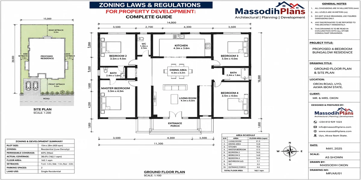
- Setbacks minimum distances from road boundaries, side and rear property lines, and drainage or waterway reserves
- Parking and access requirements particularly relevant for higher-density or commercial development
Why Zoning Exists
Zoning exists to prevent exactly the kind of conflict that makes neighborhoods and cities function poorly a factory operating next to a family home, a high-rise blocking light and air from an established residential street, or unchecked density overwhelming roads and drainage infrastructure never designed to carry it. It also gives developers a degree of predictability: knowing a plot is zoned strictly residential tells you, before you buy it, what kind of neighbors and future development to expect around it.
Zoning Categories You’ll Commonly Encounter
While specific terminology differs by country, most systems use some version of the following:
Residential further split in many systems into low-density (single-family), medium-density, and high-density classifications
Commercial retail, office, and mixed commercial use
Industrial light and heavy industrial, often with additional environmental controls
Agricultural typically the most restrictive in terms of allowable structures and density
Mixed-use increasingly common in urban infill areas, blending residential and commercial use within the same zone
Special or overlay zones layered on top of a base zoning category to address a specific concern: heritage protection, flood risk, transit-oriented development, or environmental sensitivity
How Zoning Varies by Country
This is where most zoning guides nearly all of them written from a US perspective stop short. Zoning frameworks and terminology differ meaningfully across the countries covered throughout this guide:
United States: Zoning is set almost entirely at municipal or county level, often coded (R-1, C-2, and similar designations), with variances and conditional use permits available where a project doesn’t fit the base zoning exactly.
United Kingdom and Ireland: Zoning considerations are folded into the broader planning permission process rather than treated as a standalone designation system, assessed against a Local Plan or County Development Plan.
Nigeria: Zoning is established through state-level master plans and physical development plans, enforced by state Ministries of Lands and Physical Planning, with land use rights ultimately anchored in the Land Use Act of 1978.
Germany, Austria, and Switzerland: Zoning is confirmed through a local development plan (Bebauungsplan, Flächenwidmungsplan) checked directly as part of the building permit application itself, rather than a separate upfront process.
Singapore: Land use zoning is set nationally through the Urban Redevelopment Authority’s Master Plan, with Written Permission confirming a project’s compliance before building plan approval can proceed.
Confirming Your Zoning Classification: A Practical Process
Step 1: Find your zoning designation. Most planning or municipal authorities maintain a zoning map, increasingly available as an online, address-searchable GIS tool. Where this isn’t available digitally common in many Nigerian states visit the relevant Ministry of Lands and Physical Planning directly.
Step 2: Read the actual permitted use list for that zone. Don’t assume based on the zone’s name alone. A zone labeled “mixed-use” may still restrict specific activities, densities, or hours of operation.
Step 3: Check for overlay restrictions. A plot’s base zoning might allow your project, but an overlay heritage protection, flood risk, or an environmental buffer can impose additional conditions or outright restrictions on top of it.
Step 4: Confirm setback and density figures for your specific zone. These numbers are rarely uniform even within one zoning category, and can shift based on road classification or neighboring land use.
Step 5: Get it in writing. A verbal confirmation from an agent, seller, or planning office clerk is not the same as a written zoning confirmation letter. Request one before finalizing a land purchase or committing to a design.
When Your Project Doesn’t Fit the Zoning
If your intended use doesn’t match the plot’s current zoning classification, you generally have three paths, though availability depends on your jurisdiction:
- Variance or dispensation a formal request for a specific exception to one or more zoning standards (height, setback, or use), typically requiring justification and sometimes a hearing
- Conditional use permit approval for a use that’s allowed in the zone but only under specific conditions
- Rezoning application a request to formally change the plot’s zoning classification, generally the slowest and most involved of the three options, sometimes requiring an amendment to the area’s broader master plan
Rezoning is rarely fast anywhere in the world. If your project depends on a zoning change rather than working within existing classification, build a realistic timeline often many months longer than a standard permit process into your planning from day one.
Common Mistakes I’ve Seen Repeatedly
Purchasing land based on a seller’s or agent’s verbal assurance of zoning classification, only to discover during the approval process that the actual designation didn’t match
Assuming a neighboring property’s use reflects the plot’s actual zoning informal or long-standing uses don’t always mean the zoning permits them
Overlooking overlay zones entirely, particularly drainage, flood, or heritage overlays that carry additional restrictions layered on top of base zoning
Designing before confirming density and setback limits, resulting in costly redesign once the actual figures are confirmed
A Note From Practice
I have handled cases where clients purchased plots assuming commercial zoning based on nearby developments, only to discover the specific plot remained designated for low-density residential use requiring either a lengthy rezoning application or a substantially scaled-back project. This isn’t unique to Nigeria; the same pattern assumption instead of written confirmation causes project delays and redesigns in the US, UK, and everywhere else I researched for this guide.
A Practical Zoning Checklist
- ☐ Identified the plot’s exact zoning classification through the official planning authority, not a secondhand source
- ☐ Confirmed permitted uses for that specific zone in writing
- ☐ Checked for any overlay restrictions heritage, flood, environmental, or transit-related
- ☐ Confirmed current setback, height, and density limits for your specific zone and road classification
- ☐ Verified zoning compliance before purchasing land, not after
- ☐ If your project doesn’t fit current zoning, confirmed which path variance, conditional use, or rezoning applies in your jurisdiction, and its realistic timeline
- ☐ Kept written confirmation of your zoning status on file for future reference, resale, or dispute
To complete this lesson read the following parts of the article:
- Planning Permission and Building Permits for Residential Construction: Complete Guide
- How to Apply for a Building Permit: Requirements, Documents, Costs & Process
- Building Permit Requirements by Country: Complete Global Guide
- House Plans: Complete Guide to Floor Plans, Building Drawings, Home Designs & How to Design a House
- House Plan Selection Guide: How to Choose the Right House Plan for Your Land, Budget and Lifestyle
- Land-Buying Checklist: 100+ Things to Check Before Buying Land in Nigeria
- Building Project Budget Template: Complete House Construction Cost Planner
- Homeowner’s Construction Checklist: 150+ Things to Check Before and During Building
- Building Materials Checklist: 100+ Materials You May Need When Building a House
- Site Analysis Checklist: 50+ Things to Check Before Building on Your Land
- House Planning Checklist: 50+ Essential Things to Check Before Building a House (Complete Guide)
- Building Cost Calculator Nigeria: Estimate Your House Cost in 60 Seconds
Related Articles to Guide You right
- Can I Change the Use of My Land? Planning Rules and Approval Process
- What Is the Zoning of My Property? How to Check Zoning Before Building
- What Can I Build On My Land? How to Find Out What You Can Build There?
- House Floor Plans: 3, 4 & 5 Bedroom Modern Home Plans With Dimensions and Practical Layouts
- Can I Build on This Land? How to Check the Plot Before Building a Home
- Planning Permission Explained: Everything You Must Know Before Building on Your Land
- Am I About to Overpay for This Property? A Simple Guide to True Value
- How Do I Know the True Value of a Property? Before You Buy or Sell It
- Is This Property Actually Worth the Asking Price? What to Check First!
- Is This Neighbourhood a Good Place to Live? What to Check Before Buying
- I Don’t Know Which Location to Buy In: How to Choose the Best Location
- I Don’t Know What Type of Property I Should Buy: Here’s How to Actually Decide
- Can’t Find a Property Within Your Budget? Here’s the Part Nobody’s Telling You
- I Don’t Know Where to Find the Right Property in Nigeria | Buyer Guide
- I Need a Real Estate Agent to Help Me Buy a Property in Nigeria Safely
- Property for Sale in Nigeria: The Buyer’s Guide Nobody Publishes Today
- How Do I Get Natural Ventilation? Best Ways to Improve Airflow at Home
- Where Should My House Face? Best Direction for Sun, Wind and Comfort
- I Can’t Understand or Visualize My Floor Plan — Let’s Fix That Right Now
- My Floor Plan Has Poor Circulation: How to Fix It and Improve Flow
- I Don’t Know How to Arrange My Rooms: Here’s How to Actually Figure It Out
Author
Massodih Okon is a Nigerian built-environment professional with academic and professional experience in urban and regional planning, geography, architectural design, Landscape Design, GIS and land development.
He holds a Master’s degree in Urban and Regional Planning from the University of Uyo and a first degree in Geography and Regional Planning.
Through MassodihPlans, he publishes practical guides on Nigerian house plans, building design, physical planning, site planning, development approval and residential construction. Read the full author profile →