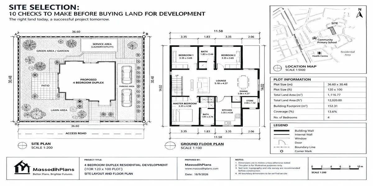
Site Selection: How to Choose the Right Land for Any Development Project
A few years ago, a client came to me after he had already bought his land. He was proud of it a good price, a nice frontage, close to a major road. He wanted me to design a beautiful modern duplex on it. When I visited the site, I found out the plot sat inside a natural water channel that flooded every rainy season, the soil test would almost certainly call for an expensive raft foundation, and the “close to a major road” plot had no legal right of way connecting it to that road. He had done everything backwards. He picked the land first, based on price and appearance, and only brought in a professional after the money had already changed hands.
That story repeats itself constantly, across house plots, shop sites, warehouses, and school buildings, because most people treat site selection as a real estate decision instead of a technical one. It is both. This guide is written to close that gap not as a list of vague tips, but as the actual process a planner uses to tell a good site from a site that will quietly cost you double your budget and years of regret.
What Is Site Selection?
Site selection is the structured process of identifying, evaluating, and choosing a piece of land that best satisfies the specific requirements of a project whether that project is a family home, a retail shop, a factory, a school, or a hospital. It is not the same as “finding land.” Finding land is easy in most Nigerian cities; agents will show you ten plots by the weekend. Site selection is the discipline of testing each of those plots against the actual demands of what you intend to build there, before you commit money to any of them.
The process matters because land is the one input in a construction project you genuinely cannot fix later. You can change a contractor, revise a design, switch a finishing material you cannot relocate a building once it’s built on the wrong ground. Every other decision in a project is downstream of this one, which is exactly why it deserves more rigor than “I liked the location.”
Site Selection Criteria: What You’re Actually Measuring
Every serious site selection process runs against a defined set of criteria the measurable factors that determine whether a piece of land can support your project safely, legally, and affordably. These generally fall into five groups.
Physical and environmental criteria soil bearing capacity, topography and slope, drainage pattern and flood history, groundwater level, and proximity to erosion-prone or waterlogged terrain.
Legal and regulatory criteria title type (Certificate of Occupancy, Governor’s Consent, customary/family land), zoning classification, permitted land use, setback and density rules, and any government acquisition or right-of-way encumbrance on the land.
Access and infrastructure criteria road access and its legal status (is it a gazetted public road or a private track?), distance to the nearest tarred road, availability of electricity, water supply, and drainage infrastructure in the area.
Economic criteria purchase price relative to comparable plots, cost implications of the soil and drainage conditions (a “cheap” plot with poor soil can cost more overall than a pricier plot with good soil), and the land’s likely appreciation given surrounding development trends.
Social and locational criteria neighbourhood security, proximity to schools, markets, or workplaces depending on the project type, and compatibility with the character of the surrounding area.
None of these criteria work in isolation that’s the part people miss. A plot can score brilliantly on price and access while failing badly on soil and legal title, and the failing criteria are usually the ones that surface only after money has changed hands. This is exactly why criteria need to be weighed together, not checked off one at a time, which is where site selection analysis comes in.
Site Selection Analysis: Turning Criteria Into a Decision
Site selection analysis is the process of applying your criteria systematically across multiple candidate sites so you can compare them fairly, instead of relying on gut feeling about which one “feels right.” In practice, this looks like a simple weighted comparison.
Start by listing every candidate site down one side of a table and every criterion across the top soil condition, title status, road access, flood risk, price per square metre, distance to key facilities. Score each site against each criterion, typically on a simple scale (say, 1 to 5), and assign a weight to each criterion based on how much it actually matters for your specific project. For a family home, soil condition and title legitimacy might carry the heaviest weight. For a retail shop, footfall and road visibility might outweigh almost everything else.
Multiply each score by its weight, total the results per site, and you have a defensible ranking not a perfect answer, but a far better basis for a six or seven-figure decision than “the agent said it’s a good area.”
Do this analysis on paper or a simple spreadsheet before you visit any site with a decision to buy in mind. Once you’ve physically stood on a plot you like, emotion creeps into the scoring whether you intend it to or not. Score first, visit to verify, not the other way round.
Site Suitability and Site Suitability Analysis
Site suitability asks a narrower, more technical question than general site selection: given this specific piece of land’s physical and environmental characteristics, is it actually fit to carry the type of development you intend to put on it? A site can be legally clean and well-located and still be unsuitable poor bearing capacity, a high water table, or a location inside a designated flood plain can all make land unsuitable regardless of how attractive its title and location are.
Site suitability analysis is the technical process of testing this combining soil investigation, topographic survey, hydrological assessment (how water moves across and around the site), and sometimes environmental impact considerations into a single judgment of whether the land can carry your intended structure safely and at a defensible cost. For a small residential plot, this might be as simple as a soil test and a visual drainage assessment. For a factory, hospital, or multi-unit estate, it becomes a formal, multi-discipline study involving geotechnical engineers, hydrologists, and sometimes environmental consultants.
This distinction general site selection versus focused site suitability is where a lot of self-builders get into trouble. They complete the “selection” part (comparing price, location, and title across a few plots) and skip the “suitability” part entirely, assuming that if the land looks fine and the papers are clean, the ground underneath will cooperate. It often doesn’t, and foundation cost is where that assumption gets expensive fastest.
Land Suitability Analysis: The Bigger-Picture Version
Land suitability analysis operates at a wider scale than a single site suitability check it’s the method used to evaluate large areas of land, sometimes an entire district or region, to determine which zones are best suited for which land uses: residential, agricultural, industrial, or conservation. This is the tool town planners and urban designers use when deciding how a whole area should grow, and it’s built from the same logic as site-level suitability, just applied across many more variables and a much larger footprint.
A typical land suitability analysis layers multiple data sets on top of each other slope, soil type, flood zones, existing land use, proximity to infrastructure, distance from environmentally sensitive areas and combines them using a multi-criteria decision method to produce a suitability map showing which zones score highest for a given purpose.
This is precisely the kind of analysis that should sit behind government layout plans and master plans, though in much of Nigeria it’s applied inconsistently, which is a large part of why some approved layouts still end up with waterlogged plots or roads that flood every rainy season. If you’re evaluating a plot inside a private estate or new layout, it is worth directly asking whether any land suitability analysis was conducted before that layout was carved out, because the answer tells you a great deal about how reliable the surrounding infrastructure and drainage design is likely to be.
Site Feasibility and the Site Feasibility Study
Site feasibility takes suitability one step further by asking not just “can this land physically carry the project” but “does building here make overall sense, financially and practically?” A site can be technically suitable and still not be feasible the cost of the foundation work the soil requires, the distance from utilities, or the price of bringing access roads up to standard can make an otherwise buildable site a poor financial decision.
A site feasibility study is the formal document that answers this question, and for any project beyond a single private home, it should cover:
- A summary of the physical suitability findings (soil, topography, drainage)
- Legal and title verification, including any encumbrances
- Infrastructure availability and the cost of bringing in what’s missing (access road upgrade, power connection, borehole where public water is absent)
- An estimated total development cost specific to this site, not a generic per-square-metre figure
- Zoning and regulatory compliance, including any approval risk
- A comparison against at least one alternative site, where possible, so the feasibility conclusion isn’t made in isolation
For homeowners and small developers, a full formal feasibility document is often unnecessary but the questions above should still be answered informally before you commit funds, because skipping them is exactly how a “good deal” on paper turns into a project that costs 40% more than budgeted once construction actually starts.
Never treat a soil test as optional because “the neighbours built fine.” Soil condition varies significantly even within the same street, especially near reclaimed land, old water channels, or filled swampland all of which are common across Nigerian coastal and riverine cities. A soil test costing a few hundred thousand naira can save you tens of millions in unexpected foundation cost.
Property Site Selection vs. Building Site Selection
These two terms get used interchangeably, but there’s a useful distinction worth understanding. Property site selection is typically the broader real estate exercise evaluating land primarily as an investment or acquisition, weighing location, price trend, title security, and resale potential, often before any specific building design exists.
Building site selection is narrower and more technical it’s the process once you already know what you intend to build, testing the land specifically against that structure’s requirements: foundation demands, floor area needed, orientation for natural light and ventilation, and access requirements specific to that building type. A plot can be an excellent property investment and a poor building site for your specific design, or vice versa a plot with a difficult site suitability profile might still be a smart long-term property acquisition if you’re prepared to invest in the ground work.
Knowing which lens you’re actually using at any given moment prevents a common confusion I see in first-time land buyers: falling in love with a plot’s investment potential while quietly ignoring the technical warning signs that make it a difficult building site.
Residential Site Selection
For a family home, site selection carries its own specific weight of priorities, beyond the general criteria already covered.
Soil and foundation cost relative to house size a modest bungalow can absorb a slightly difficult soil condition more easily than a large duplex can
Neighbourhood trajectory is the area developing toward the kind of residential character you want, or trending toward commercial/industrial encroachment that will change the neighbourhood’s character over the next decade
School, market, and workplace proximity genuinely matters for daily quality of life, not just resale value
Drainage relative to neighbouring plots as covered in our piece on how buildings relate to their neighbourhood, a residential plot’s flooding risk is rarely just about its own ground; it’s about how water moves across the whole block
Security and access road condition, especially for family members who’ll be commuting daily rather than visiting occasionally
Because a home is typically a decades-long commitment rather than a short-term investment, residential site selection should weight long-term neighbourhood trajectory and drainage more heavily than a pure price comparison would suggest.
Commercial Site Selection
Commercial projects shops, offices, event centres, hospitality flip several of the residential priorities on their head. Visibility and footfall often outweigh quiet neighbourhood character; proximity to competing or complementary businesses can be an asset rather than a concern; and road frontage width and vehicle access frequently matter more than the plot’s depth.
Key commercial-specific factors include:
Visibility and road frontage a shop set back from the road with poor sightlines will underperform an identical shop with strong street presence, regardless of interior design quality
Parking capacity and access for delivery vehicles, which residential plots rarely need to account for at the same scale
Zoning compliance for commercial use, since building or converting a commercial structure on land zoned strictly residential is a common and costly regulatory mistake
Proximity to target customer base a site’s suitability here is defined entirely by who you’re trying to reach, not by general neighbourhood desirability
Utility capacity, since commercial operations (especially food service, retail cold storage, or light manufacturing) often demand power and water capacity beyond typical residential connections
Industrial Site Selection
Industrial site selection operates under yet another set of priorities, generally dominated by logistics, environmental compliance, and infrastructure capacity rather than aesthetics or neighbourhood character.
Heavy vehicle access road width, turning radius, and pavement strength suitable for trucks and freight movement, not just cars
Distance from residential areas, both for regulatory compliance and to avoid nuisance disputes over noise, traffic, or emissions
Power supply capacity, often the single most decisive factor, since industrial operations frequently require dedicated feeders or higher-capacity connections unavailable in typical residential or commercial zones
Environmental and effluent considerations proximity to water bodies, waste disposal requirements, and environmental impact assessment obligations that residential and most commercial projects never encounter
Land banking potential for expansion, since industrial operations often grow over time and a site with no room to expand becomes a limiting factor within a few years of operation
For any commercial or industrial project, get written confirmation of available power capacity from the relevant utility provider before finalizing site selection not a verbal assurance from the seller or agent. Power capacity claims are one of the most commonly overstated factors in land sales pitches across Nigeria.
GIS Site Selection: Using Data Instead of Guesswork
This is the layer almost no site selection article aimed at Nigerian readers actually explains properly, and it happens to be the part of my own training and daily practice as a Town Planner with GIS expertise.
GIS (Geographic Information System) site selection uses layered spatial data satellite imagery, topographic data, soil maps, flood zone data, existing land use, road networks, and infrastructure locations to evaluate multiple candidate sites objectively rather than relying purely on site visits and anecdotal local knowledge. The dominant project criteria are applied progressively to identify a shortlist of potential sites showing the strongest fit with the project’s requirements, with GIS tools used specifically to evaluate and rank those candidates once criteria have been defined.
In practice, a GIS-based site selection process typically layers the following:
Elevation and slope data to flag sites vulnerable to erosion or requiring expensive earthworks
Flood zone and drainage pattern mapping to identify sites within known flood-prone corridors before a single soil test is even commissioned
Existing land use and zoning layers to confirm a candidate site’s classification and surrounding use pattern
Infrastructure proximity layers distance to tarred roads, power lines, and water infrastructure
A weighted overlay combining all layers into a single suitability score per site, using the same weighted-criteria logic covered earlier, but applied spatially across an entire map rather than a handful of manually compared plots
For an individual homeowner, full GIS analysis is rarely necessary the weighted comparison table covered earlier does the same job at a smaller scale. But for developers handling estate layouts, government agencies planning public facilities, or investors comparing multiple candidate sites across a wider area, GIS-based suitability analysis is the professional standard, and it’s worth specifically asking any consultant or agency you engage whether this method was used, particularly for any land being sold as part of a “planned” estate or layout.
Site Selection Factors No One Talks About
Beyond the standard criteria already covered, a few factors consistently get missed in site selection conversations, and they are frequently the ones that cause the most expensive regrets.
Boundary and survey accuracy a plot’s advertised size and its actual, professionally surveyed boundary don’t always match. Always commission an independent survey before finalizing purchase, rather than relying on the seller’s existing survey plan alone.
Legal right of way a plot can have excellent road proximity on a map while having no actual, legally documented right of access to that road across intervening land. This is precisely the problem my client from the opening story ran into, and it is disturbingly common.
History of the land was it previously a burial ground, a waste dump site, a water channel, or subject to a community dispute? Local inquiry, not just paperwork, often surfaces this kind of history long before any official document would.
Community and communal land dynamics particularly relevant across much of Nigeria, where family or communal land disputes can resurface years after a sale, even where documentation initially appeared clean. Verifying the full chain of title and confirming there’s no parallel claim from another family member is a step worth the extra time it takes.
Future infrastructure plans a government road expansion, drainage channel, or power line right-of-way plan can affect a site years after purchase in ways not visible during an ordinary site visit. Checking with the local planning authority for any existing master plan or infrastructure proposal covering the area is a step almost nobody takes, and one that has saved more than one of my clients from a very costly surprise.
The Cost of Getting Site Selection Wrong
It’s worth being direct about what a poor site selection decision actually costs, because the abstract advice above only lands once the financial reality is clear.
A site with poor bearing capacity can add tens of millions of naira to foundation cost alone compared to a site with good soil, on an otherwise identical building. And a site without a legally secured right of way can become entirely unbuildable, turning a land purchase into a stranded asset. A site inside an unmapped flood corridor can suffer recurring damage that erodes any price advantage it originally offered within a few rainy seasons. A site with a disputed or defective title can result in total loss of the purchase price, with no legal recourse if due diligence wasn’t properly done beforehand.
None of these outcomes are rare or exaggerated they are the recurring pattern behind most of the “my land is giving me problems” conversations I have with clients, and in almost every case, the root cause traces back to a site selection process that skipped one or more of the layers covered in this guide.
A Practical Site Selection Checklist
Bringing everything together, here is the sequence I actually walk clients through before any land purchase:
- Define your project’s specific requirements first size, use, budget ceiling before viewing any land
- Shortlist candidate sites and score them against weighted criteria (legal, physical, access, economic, social)
- Commission an independent survey and verify boundaries against the seller’s documentation
- Verify title chain, confirm there’s no communal or family dispute, and check for government acquisition or encumbrance
- Commission a soil test and basic drainage/flood-history assessment for your top-ranked candidates
- Confirm legal right of way and access, not just proximity to a road
- Check zoning classification and confirm it matches your intended use
- Inquire locally about the land’s history beyond what documentation shows
- Check with the local planning authority for any existing master plan or infrastructure proposal affecting the area
- Only after all of the above, finalize your decision and proceed to purchase
Budget for due diligence as its own line item survey, soil test, and legal verification typically cost a small fraction of the land price itself, but skipping them to “save money at the buying stage” is the single most common false economy I see in land transactions.
Frequently Asked Questions
What is the difference between site selection and site suitability?
Site selection is the broader process of comparing and choosing among candidate sites using multiple criteria. Site suitability is the narrower technical question of whether a specific site’s physical characteristics can safely and affordably support your intended project.
Do I need a feasibility study for a personal home, or only for large projects?
A full formal feasibility study is usually unnecessary for a single family home, but the core questions it answers cost of ground conditions, infrastructure availability, legal clarity should still be answered informally before you buy, since skipping them causes the same problems at a smaller scale.
What is the most commonly overlooked site selection factor in Nigeria?
Legal right of way and communal land disputes are consistently the two factors that surface as expensive problems after purchase, precisely because they aren’t always visible in a straightforward site visit or even in a seller’s existing paperwork.
Is GIS site selection only relevant for large developers?
Full GIS analysis is most relevant for developers, government agencies, and estate layouts, but the underlying logic — comparing multiple data layers rather than relying on a single site visit is worth applying at a smaller scale even for an individual land purchase.
How much should I budget for due diligence before buying land?
Survey, soil testing, and legal/title verification typically represent a small percentage of the land purchase price, but the exact figure depends on plot size and location — the important principle is treating this as a required cost, not an optional extra.
Conclusion
Site selection done properly is quieter and less exciting than picking land based on price and appearance, and that’s exactly why so many buyers skip it right up until the soil test comes back badly, the right of way turns out not to exist, or the rainy season reveals what the drainage pattern was always going to do. Every layer covered here criteria, suitability, feasibility, GIS analysis, and the due-diligence checklist exists for one reason: land is the one decision in your project you cannot undo once you’ve built on it.
If you’re currently comparing plots for a home, shop, or larger development, our Services page outlines how we support clients through site evaluation and due diligence before any design work begins. Browse our Plans Library for building designs that pair well with the site types covered in this guide, or visit Plan School to understand how site conditions feed into the approval and building plan process. You can also explore more land, planning, and construction guides on our Homepage.
- KNUPDA Building Approval Requirements: What Kano Developers Should Prepare
- ANSPPB Building Approval Requirements: What Anambra Developers Need Before Applying
- Development Management: How to Get Approval for Land Development Projects
- OCDA Building Approval Requirements (Owerri): Documents and Steps You Need
- Facility Management: Complete Guide to Managing Buildings and Property
Author
Massodih Okon is a Nigerian built-environment professional with academic and professional experience in urban and regional planning, geography, architectural design, Landscape Design, GIS and land development.
He holds a Master’s degree in Urban and Regional Planning from the University of Uyo and a first degree in Geography and Regional Planning.
Through MassodihPlans, he publishes practical guides on Nigerian house plans, building design, physical planning, site planning, development approval and residential construction. Read the full author profile →