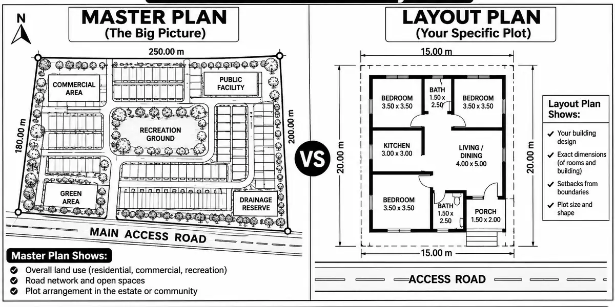
master plan vs layout plan
Picture a man who sells his car and borrows from his cooperative to buy a plot. The seller shows him a beautiful map with neat rectangles, and he pays. Two years later, he starts foundation and the planning office stops him. “That plot is on a road that was planned long ago,” they say. Or worse: “That area is for drainage.”
That man did not lack money or sense. He lacked one simple thing: he did not know the difference between a master plan and a layout plan.
Here is the answer, plain and simple.
A master plan is the big, long-term picture for a whole town or district. It decides where roads, housing, markets, industry, schools, drainage and green areas should go over the next 20 years or so. A layout plan is the detailed map for one piece of land. It shows the exact plots, roads, setbacks, open spaces and utility routes inside that land. The master plan says what the area should become. The layout plan says how this particular land will be cut up and used. Every good layout plan must fit inside a master plan.
Read that again, because it can save you millions of naira.
In this article I will talk to you like a friend, so that anybody, student, landowner, estate developer or government staff, can understand it.
Quick Summary (for people in a hurry)
Master plan: the vision for the whole settlement. Big scale. Long term. Flexible.
Layout plan: the detailed design for one site or estate. Small scale. Exact plots and roads. Ready for approval and demarcation.
Rule of thumb: master plan first, layout plan second, building plan third.
Before buying land: ask which master plan covers the area, and whether the layout is approved.
Master Plan vs Layout Plan: Side-by-Side
| Point | Master Plan | Layout Plan |
|---|---|---|
| Covers | Whole town, city or district | One site, estate or neighbourhood |
| Time frame | Long term (about 15 to 25 years) | Short to medium term |
| Detail | General: zones, main roads, key services | Exact: plots, plot sizes, road widths, setbacks |
| Main job | Guide growth and protect the public interest | Divide land and guide development on the ground |
| Scale (typical) | Small scale, big area | Large scale, small area |
| Who uses it | Government, planners, investors | Developers, surveyors, plot buyers, development control |
| Comes | First | After the master plan, before building plans |
Scales and time frames are typical. Your state planning authority may set its own, so confirm locally.
What Is a Master Plan? (The Big Picture)
During my undergraduate studies in Town Planning, one thing our lecturers constantly emphasized was this: a master plan is a guide for decisions, not a drawing to frame on the wall.
Think of a master plan as the town’s roadmap. It answers questions like these:
- Where should houses go, and where should factories go?
- Which road will carry heavy traffic, and which will be a quiet street?
- Where will the drainage channels run, and which land must stay open?
- Where should the next school, clinic and market be?
Land use distribution
A master plan shares land among uses. Here is a simple example for a new 20-hectare (200,000 m²) district. These percentages are illustrative, because your local standards may differ.
| Land use | Share | Area (m²) |
|---|---|---|
| Residential | 50% | 100,000 |
| Roads and circulation | 20% | 40,000 |
| Open space and green areas | 10% | 20,000 |
| Commercial and mixed use | 8% | 16,000 |
| Institutions (schools, worship, health) | 7% | 14,000 |
| Utilities and drainage reserves | 5% | 10,000 |
| Total | 100% | 200,000 |
If you see a plan where nearly everything is plots and almost nothing is left for roads, drainage and open space, be careful. That plan is selling land, not planning a community.
Zoning hierarchy
Zoning is the “who lives where” rule. In practice, it usually goes from the strictest to the most mixed:
- Residential (low, medium and high density)
- Commercial (shops, offices, markets)
- Industrial (light and heavy)
- Institutional (schools, hospitals, worship centres, government)
- Recreational and open space
- Special zones (flood-prone land, conservation, utilities)
Population projection
A master plan must plan for people who are not yet born or have not yet arrived. A simple formula planners use is:
Pt = P0 × (1 + r)^n
Where P0 is today’s population, r is the yearly growth rate and n is the number of years.
Worked example: a district has 5,000 people today and grows at 3% yearly. In 20 years: 5,000 × (1.03)^20 = 5,000 × 1.806 ≈ 9,030 people. That means you must plan water, schools, roads and clinics for about 9,000 people, not 5,000. Use your own area’s real growth rate, not mine.
Urban growth strategy and development phases
A good master plan does not grow in all directions at once. It chooses a direction (for example, along a new road), protects land for future roads, and releases land in phases:
- Phase 1: land near existing roads and services
- Phase 2: extend trunk roads, water and drainage
- Phase 3: open outer areas only when services can reach them
From what I have seen in practice, towns that skip phasing end up with houses everywhere and services nowhere.
What Is a Layout Plan? (The Detailed Map)
If the master plan is the roadmap of the whole town, the layout plan is the map of your street.
A layout plan takes a piece of land and shows:
- Plot boundaries and plot numbers
- Plot sizes (for example, 15 m × 30 m = 450 m²)
- Road widths and road names
- Drainage lines and setbacks
- Open spaces, playgrounds, market and school sites
- Utility corridors for water, electricity and drainage
Plot arrangement: a worked example
Take a 2-hectare estate (20,000 m²). Suppose we give:
- 25% to roads and drainage = 5,000 m²
- 10% to open space = 2,000 m²
- 5% to a small commercial and community area = 1,000 m²
- Balance for residential plots = 20,000 − 8,000 = 12,000 m²
Divide by a plot size of 450 m² (15 m × 30 m): 12,000 ÷ 450 ≈ 26 plots.
Now you see why a seller who promises “40 plots on 2 hectares” must explain where the roads, drainage and open space went. Plot size, road width and open space are linked. You cannot squeeze one without hurting another.
Setbacks and open space
Setbacks are the empty distances between your building and the plot boundary or road. They give light, air, fire safety and space for future road widening. The exact distances depend on your state and zone, so always confirm with your planning authority. I explain this in How to Find the Setbacks Holding You Back and Build a Plan for Your Reality Now!.
This is something I have encountered many times: people draw a nice house, then discover the setbacks eat the plot. Always check setbacks before you finalise your house design. PLANS-LIBRARY has small-plot plans designed with setbacks in mind.
Road hierarchy
Roads must be ranked, like a family tree. Widths below are typical reserves and should be confirmed locally:
| Road type | Job | Typical reserve |
|---|---|---|
| Arterial | Carries traffic across the town | 30 m or more |
| Collector | Links neighbourhoods to arterials | 15 to 20 m |
| Local street | Reaches the houses | 9 to 12 m |
| Access lane or footpath | Short link, walking | 6 m or less |
If every road in an estate is the same narrow width, you will meet traffic, parking wahala and trouble for fire trucks and ambulances.
Utilities planning
A layout plan sets aside strips for water pipes, electricity poles or cables, drainage and, where possible, sewer lines. Laying these on paper is cheap. Digging them later through people’s compounds is expensive and painful.
How the Two Plans Work Together
Think of three levels:
- Master plan (the town)
- Layout plan (the estate or neighbourhood)
- Building plan (your house)
The master plan sets the rules, the layout plan applies them on one site, and your building plan fits inside the layout. If one level is missing, the next one stands on weak ground.
Development control
Development control is the planning office’s job of checking that what you build matches the plan. It checks land use, plot coverage, setbacks, height and access. While assisting with development control activities, I witnessed firsthand how a missing layout plan makes this almost impossible. The officer has nothing to measure against.
Planning approval process (general steps)
Procedures differ by state, so treat this as a general path:
- Confirm the land’s zoning and the master plan that covers it.
- Get a survey of the land.
- Prepare the layout plan (for estates) or site plan.
- Submit to the planning authority and pay the required fees.
- Respond to comments and corrections.
- Get approval, then demarcate plots on the ground.
- Apply for building permits plot by plot. See Planning Permission and Building Permits for Residential Construction: Complete Guide.
Land allocation and implementation
Land allocation is how plots are given out: by government, by community, by family or by private developers. A plan only works if it is implemented, meaning roads are cut, drainage is built, plots are pegged, and the buildings follow the rules. Many plans fail not on paper, but because nobody enforces them.
Drainage, Flooding and Environmental Management
This is where bad planning shows itself fastest in our rainy season.
In practical terms, what usually happens is this: a developer fills a low area, blocks a natural channel to gain more plots, and sells. The next heavy rain, water that used to flow freely now enters people’s houses.
A good master plan and layout plan should:
- Map natural drainage channels and keep them open
- Keep floodplains and wetlands free from building
- Provide primary, secondary and tertiary drains that connect to a proper outlet
- Plan waste collection points and a disposal route
- Protect trees and green areas that soak up water and cool the area
I did not learn this from a textbook alone. I have seen flooded compounds that were avoidable if the drain route had been respected from day one.
Climate, Sustainability and Smart Growth
Our hot, humid and rainy climate should shape the plan:
- Orient streets and plots to allow cross-ventilation
- Keep trees along streets for shade
- Use permeable surfaces where possible
- Keep roads and drains matched to rainfall
Smart growth simply means: grow compact, mix uses sensibly, keep walking and public transport possible, protect green land, and avoid sprawl. Sustainability means today’s growth should not make tomorrow’s life harder.
For more on the global view of sustainable urban growth, see the work of UN-Habitat.
Mixed-Use, Community Functionality and Future Expansion
A planned neighbourhood should work for a normal Nigerian family. That means a mother can buy food, children can walk to school, a mechanic can open a shop, and a worship centre does not disturb sleeping neighbours.
- Mixed use works when it is planned: shops on main roads, quiet homes behind
- Community functionality means a school, clinic, market, play space and a place to gather
- Future expansion means leaving land for road widening, new services and growth
Reserve the land now. Buying it back later, with demolition, costs many times more.
GIS and Mapping Integration
Modern planning uses GIS (Geographic Information Systems) to overlay information on one map: contours, rivers, flood zones, roads, plots, utilities and buildings. It helps planners see problems before drawings are finalised. Even simple tools, like satellite imagery and a good survey, make a big difference. Not every project needs advanced GIS, but every project needs reliable mapping.
Planning Standards and Regulations
Planning standards are the measurable rules: plot sizes, road reserves, open space share, school catchments, setbacks and density. They come from national and state planning laws and regulations, local zoning rules and your planning authority. These change from place to place and over time, so always confirm the current standard before you design or buy.
The Four Layers Most Blogs Ignore
1. The Nigerian Reality Layer
The theory sounds reasonable, but real projects tell a different story. In many places, land is first sold by families, plots are pegged by agreement, and planning comes late, if at all. Many layouts are drawn after houses have begun. Under these conditions, the best approach is to involve a planner early, respect the drainage, and keep documents clean.
2. The Human Lifestyle Layer
Plans should serve life: the early morning school run, the generator noise, market day, funeral and wedding crowds, church and mosque days, and okada and keke movement. When a plan ignores how people truly live, people will change the plan with their own hands.
3. The Construction Experience Layer
On site, plans meet reality: trucks need turning space, trenches meet rock or high water table, and workers need access. One lesson I learned early is that a road that looks fine on paper may be impossible to build if the slope, soil and drain are ignored.
4. The Investment Layer
A planned layout holds value. Buyers and banks prefer land with clear roads, drainage, approved layouts and documents. Poor planning reduces property value, raises infrastructure cost and scares serious investors. If you are buying land to build or resell, ask for the layout plan and the approval status before paying. It is one of the cheapest protections you can buy.
Quick Land Buyer Checklist
- Which master plan or zoning covers this area?
- Is there an approved layout plan, and can I see it?
- Does the plot number on my paper match the plot on the ground?
- Is the plot on a drainage line, floodplain or future road?
- What are the road width and setbacks?
- Is there access to water, power and drainage?
- Has a registered planner or surveyor checked it?
Mistakes to Avoid
- Buying from a “map” that is not approved
- Treating a survey plan as if it were a layout plan
- Building before confirming setbacks
- Ignoring natural drainage
- Assuming a nice road today stays that way tomorrow
- Letting sales agents reduce roads and open space to create more plots
- Skipping the planner because “the land is small”
Expert note: I have seen this mistake repeatedly: people spend heavily on a house design but nothing on checking the land first.
For Readers Around the World
The names change, but the idea is the same everywhere. If you read this from the diaspora or another country, here is how the two plans look in common systems. Always confirm with the local authority, as laws vary.
| Country | Large-scale plan | Site/layout level | Note |
|---|---|---|---|
| Nigeria | Master plan, structure plan | Layout plan, site plan | State planning authorities approve |
| United States | Comprehensive or general plan | Subdivision plat, site plan | Zoning ordinance applies |
| United Kingdom | Local Plan | Site layout in planning applications | Local planning authority decides |
| Canada | Official plan | Plan of subdivision | Municipal approval |
| Australia | Strategic and structure plans | Subdivision or development plans | State rules differ |
| Germany | Flächennutzungsplan | Bebauungsplan | Two-level system |
| UAE | Master plan | Layout or site plan | Authority approval, e.g. at emirate level |
| Singapore | Master Plan | Development layouts | Strong central control |
| South Africa | Spatial development framework | Layout or subdivision plan | Municipal approval |
Currencies and fees differ, so I recommend you budget in your own currency using local quotations (naira, dollars, pounds, euros, dirhams and so on) and not copy numbers from another country.
Frequently Asked Questions
What is the main difference between a master plan and a layout plan?
A master plan guides the whole town or district over many years. A layout plan shows exactly how one piece of land will be divided and used.
Which comes first, the master plan or the layout plan?
The master plan comes first. The layout plan should follow and fit within it.
Do I need a layout plan for a single plot?
Usually you need a site plan for your building approval. A layout plan is mainly for estates, subdivisions and larger sites. Confirm with your planning authority.
Is a survey plan the same as a layout plan?
No. A survey plan shows the boundaries and measurements of land. A layout plan shows how the land is designed and divided.
Can a layout plan be changed?
Yes, but it usually needs approval. Changing it after people have bought and built can cause serious disputes.
Who prepares these plans?
Registered town planners, often working with surveyors, engineers and architects.
How long does a master plan last?
Commonly 15 to 25 years, with reviews along the way.
How do I check if land is safe to buy?
Use the checklist above and ask a registered planner or surveyor to verify.
Conclusion: What You Should Do Next
If you remember only one thing, let it be this: the master plan decides the future of the area, and the layout plan decides the future of your plot. Check both before you pay, and your risk drops a lot.
If I were advising a client today, I would recommend this order: confirm zoning, ask for the approved layout, verify on the ground, and only then design your house.
Planning is not a luxury. It is how a place stays livable for our children. When roads, drains, schools and open spaces are in the right place, people sleep better, businesses grow and land keeps its value.
Your next steps:
- Need help with planning or land checks? See our SERVICES.
- Ready to design for a small plot? Browse the PLANS-LIBRARY.
- Want to learn the basics yourself? Visit PLAN-SCHOOL.
- Share this with someone about to buy land. It may save them a lot of stress. And you can always return to the HOME for more practical guides.
- How to Avoid Wasting Space in House Plans: Formula + Audit
- How to Create House Plans Using Graph Paper: Scale, Setbacks, Walls and Room Sizes Done Right
Author
Massodih Okon is a Nigerian built-environment professional with academic and professional experience in urban and regional planning, geography, architectural design, Landscape Design, GIS and land development.
He holds a Master’s degree in Urban and Regional Planning from the University of Uyo and a first degree in Geography and Regional Planning.
Through MassodihPlans, he publishes practical guides on Nigerian house plans, building design, physical planning, site planning, development approval and residential construction. Read the full author profile →