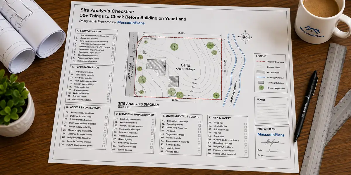
Site Analysis Checklist: 50+ Things to Check Before Building on Your Land
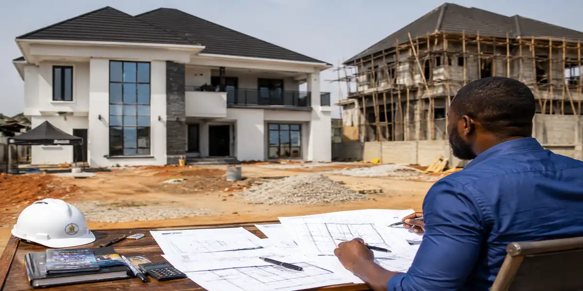
After 15 years of practice across Akwa Ibom and Rivers State, I have seen a familiar story: a client buys land, falls in love with a plan they saw online or in a friend’s compound, and starts building only to discover that the site had something to say that nobody asked it.
Buying land is only the beginning. Before you draw a house plan, clear the site, or start construction, you need to understand what the land is telling you.
Is the site accessible? Does it slope? Where does rainwater flow? What surrounds the property a market, school, or swamp? Where does the sun rise and set over the plot? Which direction does the wind travel? Are there drainage problems your neighbours know about? Is the soil suitable for the building? Are there planning restrictions? Can a lorry carrying blocks and cement reach the site?
These questions are part of careful site analysis, and it is the single most skipped step in Nigerian home building, right before “budgeting properly” and “getting a soil test.”
A beautiful house plan can perform poorly or fail outright if it is designed without considering the site. I have seen contemporary duplex designs pulled from Pinterest and placed on waterlogged plots in low-lying areas, with predictable results: cracked screed, damp walls, and compounds that turn into small lakes every rainy season.
This site-analysis checklist from MassodihPlans will walk you through the physical, environmental, accessibility and planning factors you should examine before developing a property in Uyo, Port Harcourt, Calabar, or anywhere else in Nigeria.
Important: This checklist is an educational planning tool built from field experience. It does not replace a survey, geotechnical investigation, environmental assessment, architectural design, structural assessment, or planning advice where legally required.
What Is Site Analysis?
Site analysis is the process of studying a piece of land and its surrounding environment before making important design and development decisions.
It helps you understand the opportunities and constraints of a site the things that will make your project easier, and the things that will fight you every step of the way if you ignore them.
A proper site analysis can examine:
- Location
- Site boundaries
- Dimensions
- Topography
- Soil
- Drainage
- Climate
- Sun
- Wind
- Vegetation
- Access
- Surrounding buildings
- Infrastructure
- Utilities
- Planning controls
- Environmental conditions
- Potential hazards
The purpose is simple, even if the list above looks long: understand the site before designing for it.
Too many homeowners flip that order they design first, fall in love with the design, and only “analyse” the site afterward, when it’s too late to change anything meaningful.
Why Is Site Analysis Important Before Building?
1. It helps you choose an appropriate building position
The best position for a building is not necessarily the centre of the plot. I have adjusted building setbacks on client sites specifically because the “natural” centre position would have blocked the only good cross-ventilation path on the land.
The building may need to respond to:
- Access
- Sun
- Wind
- Drainage
- Views
- Privacy
- Setbacks
- Neighbouring buildings
- Existing vegetation
2. It can reveal expensive site problems early
A site may look perfectly fine during a short weekend inspection but hide problems such as:
- Flooding
- Poor drainage
- Erosion
- Difficult access
- Unstable ground
- Significant slope
- Poor soil conditions
Discovering these issues before design and construction not during is the difference between a manageable adjustment and an expensive redesign mid-project.
3. It improves the house design
The site should influence the design, not the other way around. Instead of forcing the same trending house plan onto every plot regardless of orientation or slope, the design can genuinely respond to what the land offers.
4. It helps with environmental comfort
Understanding sunlight, wind and surrounding conditions can help inform decisions about:
- Building orientation
- Window placement
- Ventilation
- Shading
- Outdoor spaces
- Room arrangement
A house that ignores the sun’s path ends up with bedrooms that bake by 10am and living rooms nobody wants to sit in by afternoon. This is entirely preventable at the design stage.
Field Note: On almost every project I have handled, the client’s first instinct is to ask about the house plan. My first question is always about the land. A house plan is only as good as its fit to the site it’s built on.
The Complete Site Analysis Checklist
Use the following checklist before finalising your building design. Go through it item by item resist the urge to skip sections that seem “obvious.”
1. Confirm the Site Location
Start with the basics.
☐ Confirm the exact location of the property
☐ Record the address or identifiable location
☐ Record GPS coordinates where appropriate
☐ Identify the neighbourhood
☐ Identify the local government area
☐ Identify the state/region
☐ Identify nearby major roads
☐ Identify nearby landmarks
☐ Record the site’s approximate elevation where relevant
☐ Save a satellite image or location map for reference
Site location:
Address/Description: _______________________________
Coordinates: _______________________________________
Local Government Area: _____________________________
2. Confirm the Site Boundaries
Never assume that the physical appearance of a property automatically confirms its legal or surveyed boundaries. I cannot count how many “boundary disputes” I have seen begin from a fence that was built on assumption rather than survey.
☐ Confirm the four major boundaries
☐ Confirm plot dimensions
☐ Confirm plot area
☐ Identify adjoining properties
☐ Identify boundary walls or fences
☐ Check whether physical boundary markers exist
☐ Compare available site information with reliable survey documentation
☐ Identify any boundary disputes or uncertainties
☐ Record neighbouring property uses
Site dimensions
North: __________________________
South: __________________________
East: ___________________________
West: ___________________________
Approximate area: _______________
Where boundaries are important to the design, obtain appropriate professional survey information. Do not skip this to save money it is one of the cheapest insurance policies in the whole project.
3. Study the Site Shape
Not every plot is a perfect rectangle, no matter what the layout plan promised.
☐ Rectangular
☐ Square
☐ Irregular
☐ Triangular
☐ Corner plot
☐ Narrow/deep plot
☐ Wide/shallow plot
☐ Other: __________________________
Consider:
☐ How the shape affects building placement
☐ How the shape affects parking
☐ How the shape affects circulation
☐ How the shape affects outdoor space
☐ How the shape affects setbacks
☐ Whether irregular areas can be used effectively
4. Study the Topography
Topography describes the shape and elevation of the land. Walk around the site don’t just drive past it and determine whether it is:
☐ Relatively flat
☐ Gently sloping
☐ Moderately sloping
☐ Steep
☐ Uneven
☐ Terraced
A slope can affect:
- Building placement
- Foundation design
- Drainage
- Accessibility
- Road/driveway design
- Site preparation
- Construction costs
Do not guess precise levels when accurate information is required. A proper topographic survey may be necessary for detailed design, especially on sloping or irregular sites.
5. Check Natural Drainage
One of the most important questions on any site visit is simple: where does the water go when it rains?
☐ Identify the natural direction of surface water
☐ Identify low points
☐ Identify high points
☐ Identify existing drainage channels
☐ Look for signs of waterlogging
☐ Look for erosion
☐ Look for sediment deposits
☐ Check neighbouring properties
☐ Determine whether water flows onto the site from surrounding land
☐ Determine whether water leaves the site toward neighbouring properties
☐ Identify nearby drains
☐ Identify culverts
☐ Check the condition of existing drainage infrastructure
☐ Consider heavy rainfall conditions
Drainage observations: _______________________________________________
6. Check Flood Risk
Flood risk should never be ignored and in many Nigerian towns, it is ignored constantly because a site “looks dry” on the day of inspection, which usually happens to be the dry season.
Look for:
☐ Previous flood marks
☐ Water stains on nearby walls
☐ Sediment deposits
☐ Damaged vegetation
☐ Deep drainage channels
☐ Standing water
☐ Low-lying terrain
☐ Nearby streams or watercourses
☐ Overflowing drainage infrastructure
☐ Reports from neighbours about flooding
Ask directly: has this area experienced flooding before? Neighbours who have lived there for years will usually tell you the truth, even when the seller won’t.
Flood-risk assessment:
☐ Low concern
☐ Moderate concern
☐ High concern
☐ Requires further professional investigation
7. Study the Soil and Ground Conditions
You cannot reliably determine all soil characteristics simply by looking at the surface. However, you can identify warning signs that call for further investigation.
Look for:
☐ Very soft ground
☐ Standing water
☐ Cracks in nearby structures
☐ Erosion
☐ Unusual settlement
☐ Exposed rock
☐ Fill material
☐ Loose soil
☐ Expansive/clayey soil indicators
☐ Previous excavation or dumping
☐ Nearby foundation problems
If the proposed development requires it, obtain appropriate geotechnical or soil investigation. This is not the place to cut corners foundation problems discovered after construction are almost always more expensive than the soil test would have been.
8. Identify Existing Vegetation
Vegetation tells you more about a site than most people realise.
☐ Large trees
☐ Small trees
☐ Shrubs
☐ Grass
☐ Wetland vegetation
☐ Agricultural vegetation
☐ Invasive vegetation
☐ Dead vegetation
☐ Areas of dense growth
Consider:
☐ Which vegetation should be retained
☐ Which vegetation may interfere with construction
☐ Whether trees provide useful shade
☐ Whether tree roots may affect structures or services
☐ Whether vegetation indicates wet conditions
☐ Whether removal may require appropriate permission
Field Note: Do not remove valuable trees simply because they occupy part of the site. First consider whether the design can work around them a mature tree offering afternoon shade can save you real money on cooling over the life of the building.
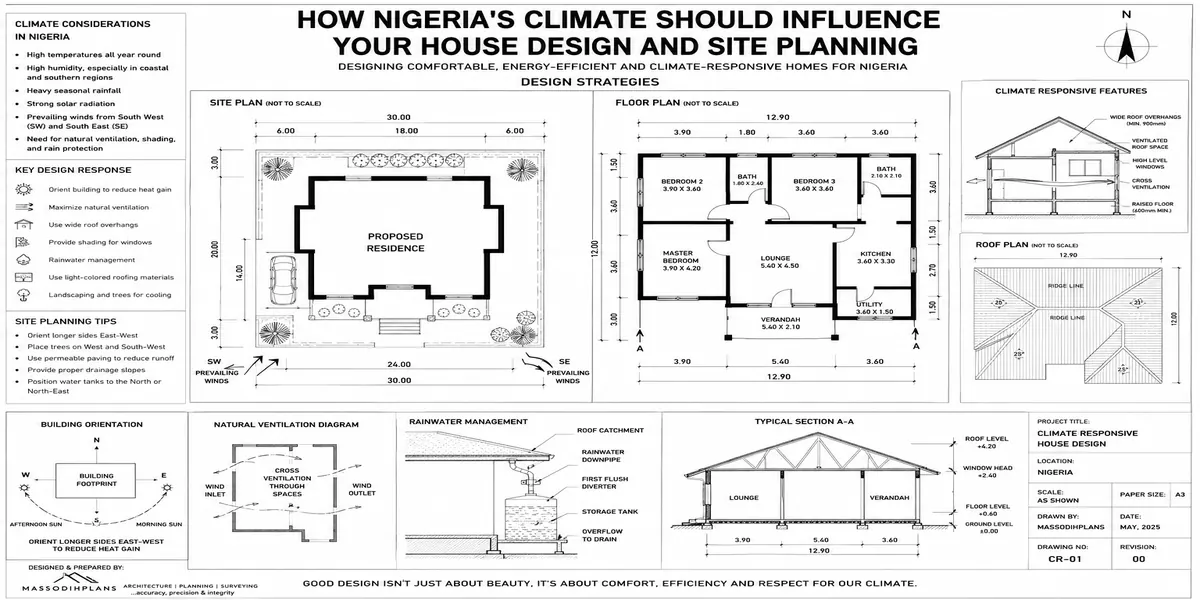
9. Analyse the Sun
Sunlight affects the comfort and performance of a building far more than most house plans account for.
Observe:
☐ Sunrise direction
☐ Sunset direction
☐ Morning sun
☐ Afternoon sun
☐ Areas receiving intense sunlight
☐ Areas receiving shade
☐ Existing shade from trees
☐ Shade from neighbouring buildings
☐ Potential future buildings that may change sunlight conditions
Consider how this information could influence building orientation, window placement, shading, outdoor spaces, bedrooms and living areas.
10. Analyse Wind and Ventilation
Understand the site’s general wind conditions.
☐ Prevailing wind direction where practical
☐ Areas with good airflow
☐ Areas blocked by buildings
☐ Existing trees that influence airflow
☐ Wind exposure
☐ Dust movement
☐ Odours carried from nearby uses
Consider whether the building can take advantage of natural ventilation cross-ventilation done properly can meaningfully reduce your dependence on air conditioning.
11. Study the Surrounding Buildings
Your site does not exist in isolation.
☐ Residential buildings
☐ Commercial buildings
☐ Schools
☐ Religious buildings
☐ Industrial activities
☐ Offices
☐ Markets
☐ Vacant land
☐ Public facilities
☐ High-rise or multi-storey buildings
Consider building heights, setbacks, privacy, noise, shadows, views, and future development around you.
12. Analyse Privacy
Think carefully about what neighbouring properties can see into your compound, and vice versa.
☐ Can neighbours see into bedrooms?
☐ And can neighbours see into living rooms?
☐ Can people see directly into your compound?
☐ Are balconies overlooking the property?
☐ And are there nearby upper floors?
☐ Where should windows face?
Good site planning can improve privacy without making the house feel closed off and airless.
13. Study Road Access
Access is one of the most important and most underrated site considerations.
☐ Identify the main access road
☐ Determine road width
☐ Check road condition
☐ Check whether the road is paved or unpaved
☐ Check whether vehicles can reach the site during rainy periods
☐ Identify the best entrance position
☐ Check whether heavy construction vehicles can access the site
☐ Check whether there are drainage channels along the road
☐ Check whether there is a culvert
☐ Check whether road levels create drainage concerns
I have seen construction delayed for weeks simply because block-laden trucks could not reach a site during the rains. Check this before you commit, not after mobilisation.
14. Analyse Traffic and Movement
Observe how people and vehicles actually move around the site not just what the road map suggests.
☐ Pedestrian movement
☐ Private vehicles
☐ Commercial vehicles
☐ Motorcycles
☐ Heavy vehicles
☐ School traffic
☐ Market activity
☐ Peak traffic periods
☐ Noise from traffic
☐ Road safety
This can influence gate position, parking, entrance location, building orientation, noise protection and pedestrian access.
15. Check Utilities and Infrastructure
Identify what infrastructure is actually available around the property not what was promised when the land was sold.
☐ Electricity supply
☐ Electricity poles
☐ Transformer
☐ Water supply
☐ Public water infrastructure
☐ Drainage
☐ Telecommunications
☐ Internet availability
☐ Street lighting
☐ Waste collection
☐ Road infrastructure
16. Identify Water Supply Options
Determine how the property will receive water. Possible sources include public water supply, borehole, well, or other appropriate sources.
☐ Existing water infrastructure
☐ Water pressure/availability where relevant
☐ Possible tank location
☐ Pump location
☐ Access for maintenance
☐ Water quality considerations
Where groundwater development is proposed, appropriate investigation and professional advice may be required.
17. Identify Wastewater and Sanitation Requirements
Consider how wastewater will be handled this is frequently an afterthought and shouldn’t be.
☐ Existing sewer connection
☐ Septic system requirements
☐ Soakaway considerations
☐ Available space
☐ Ground conditions
☐ Distance from water sources
☐ Maintenance access
☐ Local requirements
Sanitation systems should be properly planned from the start, rather than squeezed into whatever space remains after the building is designed.
18. Analyse Noise
Spend real time on the site and simply listen.
☐ Major roads
☐ Traffic
☐ Markets
☐ Schools
☐ Workshops
☐ Industrial activities
☐ Religious activities
☐ Night-time activities
☐ Construction activity
☐ Other noise sources
Consider which rooms should face quieter areas, whether bedrooms need protection from major noise, whether buffer spaces are needed, and whether landscaping can help absorb sound.
19. Identify Odours and Air Quality Issues
Pay attention to smells and air quality during your visit and visit at different times of day if possible.
Possible sources include open drains, waste disposal areas, markets, workshops, industrial activities, sewage, agricultural activities, and traffic.
☐ Identify unpleasant odours
☐ Identify their likely source
☐ Determine whether they are temporary or persistent
☐ Consider how building orientation and ventilation could respond
20. Check Nearby Environmental Hazards
Look for potential hazards:
☐ Flooding
☐ Erosion
☐ Steep slopes
☐ Unstable ground
☐ Open drainage
☐ High-voltage infrastructure
☐ Industrial pollution
☐ Waste disposal
☐ Fire hazards
☐ Unsafe neighbouring structures
☐ Other site-specific hazards
Where a serious hazard is identified, obtain appropriate professional advice before development.
21. Study the Neighbourhood
The immediate neighbourhood tells you a lot about the development context you’re building into.
☐ Predominant building type
☐ Average building height
☐ Road pattern
☐ Drainage pattern
☐ Density
☐ Land uses
☐ Security conditions
☐ Commercial activity
☐ Public facilities
☐ Green/open spaces
☐ Future development signs
Ask: does the proposed building fit appropriately into its surrounding environment?
22. Check Planning and Development Requirements
Before designing the final building, investigate the planning requirements applicable to the property. Depending on the location and project, these may relate to:
☐ Building setbacks
☐ Building height
☐ Plot coverage
☐ Floor-area considerations
☐ Parking
☐ Access
☐ Drainage
☐ Land use
☐ Road reservations
☐ Right-of-way
☐ Environmental restrictions
☐ Other planning controls
Requirements vary by jurisdiction. Obtain the relevant information from the appropriate planning authority or a qualified professional this is not an area to guess or rely on “what my neighbour did.”
23. Analyse Views
Not every direction around your property is equally attractive.
☐ Best views
☐ Poor views
☐ Neighbouring walls
☐ Attractive landscapes
☐ Roads
☐ Open spaces
☐ Water bodies where applicable
☐ Unsightly uses
You may want important rooms and outdoor spaces to benefit from good views, while using less important spaces as buffers against unattractive ones.
24. Analyse Existing Structures
If there are existing structures on the property:
☐ Record their location
☐ Record their approximate dimensions
☐ Assess their condition
☐ Determine whether they will remain
☐ Determine whether they will be demolished
☐ Identify existing service connections
☐ Identify possible reuse opportunities
☐ Identify demolition constraints
Do not assume that an existing structure can safely support a new development without appropriate professional assessment.
25. Consider Future Development
A site should not be analysed only according to what exists today.
- ☐ Is the neighbouring land vacant?
☐ Could neighbouring buildings become taller? - ☐ And Could the road change?
☐ Could commercial activity increase? - ☐ And Could drainage infrastructure change?
☐ Could surrounding density increase?
☐ And Could future development affect privacy?
☐ Could future development affect sunlight?
Good planning considers reasonable future scenarios, not just the site as it looks the day you buy it.
26. Create a Site Constraints List
After studying the site, list everything that may restrict development.
27. Create a Site Opportunities List
Do not only look for problems identify opportunities too.
☐ Good road access
☐ Attractive views
☐ Good natural ventilation
☐ Mature trees
☐ Good sunlight
☐ Flat terrain
☐ Existing infrastructure
☐ Quiet surroundings
☐ Good orientation
☐ Large usable outdoor area
☐ Convenient service connections
Site Opportunities:
28. Record Your Site Photographs
Take photographs from different directions.
☐ Front of site
☐ Rear of site
☐ Left boundary
☐ Right boundary
☐ Main road
☐ Neighbouring properties
☐ Drainage
☐ Existing vegetation
☐ Utilities
☐ Important site features
☐ Potential hazards
☐ Important views
Label your photographs with the date and direction where practical you’ll thank yourself later when discussing the site with your architect or planner.
29. Prepare a Simple Site Analysis Diagram
Your site analysis drawing can show: north direction, site boundary, roads, access, existing buildings, trees, drainage, slope, sun, wind, views, noise sources, neighbouring buildings, important utilities, opportunities, and constraints.
A simple diagram can help transform scattered observations into actual design decisions.
30. Turn Analysis Into Design Decisions
This is where site analysis becomes genuinely useful not just a report, but a design tool.
If the site receives strong afternoon sun from one direction: consider appropriate orientation, shading and window design.
And If the site slopes significantly: consider how the building, access and drainage can respond to the terrain.
If traffic noise is high along one boundary: consider placing less noise-sensitive spaces toward that side and protecting quieter areas.
Also If there is an attractive view: consider positioning important spaces to benefit from it.
If drainage is a major concern: address levels and drainage during site planning rather than after construction.
If neighbouring buildings compromise privacy: consider window placement, screening and building orientation.
This is the difference between collecting site information and actually doing site analysis.
The most common mistake I see: homeowners who conduct a thorough site walk, take good notes, then design the house completely independent of everything they just observed. The checklist only earns its value when it changes what you build.
Site Analysis Master Checklist
Before finalising your design, confirm that you have considered:
☐ Location ☐ Boundaries ☐ Dimensions ☐ Site shape ☐ Topography ☐ Soil/ground conditions ☐ Drainage ☐ Flood risk ☐ Vegetation ☐ Sun ☐ Wind ☐ Climate ☐ Views ☐ Privacy ☐ Surrounding buildings ☐ Road access ☐ Traffic ☐ Pedestrian movement ☐ Utilities ☐ Water supply ☐ Wastewater ☐ Noise ☐ Odours ☐ Environmental hazards ☐ Neighbourhood character ☐ Planning requirements ☐ Existing structures ☐ Future development ☐ Site opportunities ☐ Site constraints ☐ Site photographs ☐ Site analysis diagram ☐ Design implications
Simple Site Analysis Worksheet
SITE INFORMATION
Location: ______________________________________
Plot Size: ______________________________________
Plot Dimensions: _________________________________
Site Shape: _____________________________________
Road Access: ____________________________________
Orientation: ____________________________________
TOPOGRAPHY
Site generally: ☐ Flat ☐ Gently sloping ☐ Moderately sloping ☐ Steep ☐ Irregular
Observations: ___________________________________
DRAINAGE
General drainage direction: _____________________
Flood concern: ☐ Low ☐ Moderate ☐ High
Observations: ___________________________________
SUN
Morning sun: ____________________________________
Afternoon sun: __________________________________
Strongest exposure: ______________________________
WIND
General wind direction: __________________________
Ventilation opportunities: _______________________
ACCESS
Main road: ______________________________________
Road condition: __________________________________
Best entrance location: __________________________
SURROUNDINGS
North: __________________________________________
South: __________________________________________
East: ___________________________________________
West: ___________________________________________
UTILITIES
Electricity: _____________________________________
Water: __________________________________________
Drainage: _______________________________________
Internet/Telecommunications: _____________________
SITE CONSTRAINTS
- ___ 2. ___ 3. ___ 4. ___ 5. ___
SITE OPPORTUNITIES
- ___ 2. ___ 3. ___ 4. ___ 5. ___
Frequently Asked Questions About Site Analysis
What is the purpose of site analysis?
The purpose of site analysis is to understand the physical, environmental, accessibility, social and planning characteristics of a property before making development decisions. It helps designers identify both opportunities and constraints before those characteristics turn into expensive surprises.
Do I need a site analysis before designing my house?
Yes, especially for a new development. Even a relatively simple house can be affected by site orientation, access, drainage, topography, neighbouring buildings and planning requirements. The depth of analysis required depends on the size, complexity and location of the project.
Can I do site analysis myself?
You can carry out basic observations yourself photographs, surrounding land uses, drainage patterns, access conditions and obvious site features. However, some information requires professional expertise or equipment. Accurate boundary and level information may require surveying, while structural or soil-related issues may require specialist investigation.
What is the difference between site analysis and site survey?
A site survey is generally concerned with accurately measuring and documenting physical features and spatial information about the property. Site analysis goes further by interpreting the site’s characteristics and considering what they mean for development and design. Both matter, but they serve different purposes.
What should I look for during a site visit?
Access, boundaries, topography, drainage, flood evidence, vegetation, sun, wind, neighbouring buildings, noise, views, utilities, existing structures, planning context, and environmental hazards. Take photographs and record your observations as you go don’t rely on memory alone.
Why is drainage important in site analysis?
Poor drainage can cause waterlogging, erosion, access problems and damage to buildings and surrounding infrastructure. Understanding how water moves across and around the site allows drainage considerations to be built into the development from day one, rather than fought after the fact.
Conclusion
A building does not exist independently of its site. The land influences the building, and the building changes the land.
That is why good design should always begin with understanding the site not with a plan you saw somewhere and liked.
Before you finalise your house plan, take the time to examine the plot, surrounding roads, neighbouring buildings, topography, drainage, vegetation, sunlight, wind, utilities, environmental conditions and applicable planning requirements. Then turn those observations into actual design decisions.
The goal is not simply to produce a checklist with many ticks. The goal is to answer one important question:
“What is this site telling me about how I should develop it?”
When you understand the answer, you can make better decisions about where to position the building, how to orient it, how to access it, how to manage drainage, how to arrange spaces, and how to respond to the surrounding environment.
Analyse the site first. Design second. Build third.
Need Help Understanding Your Site?
MassodihPlans provides practical built-environment information and services related to site planning, house planning, architectural design, town planning, GIS/mapping and landscape design.
If you have land but are unsure how its size, shape, access, slope, surroundings or other characteristics should influence your proposed development, proper site analysis is the right place to start.
Browse our Plans Library for house designs that respond to real site conditions, learn the fundamentals in Plan School, check Services for site analysis and planning support, or return to the Homepage for more practical guides.
Reference: Federal Ministry of Housing & Urban Development
MassodihPlans: Plan Better. Build Smarter.