The Small Number on Your Survey Plan That Could Save (or Cost) You Your Land
What Is a Beacon Number on a Survey Plan in Nigeria?
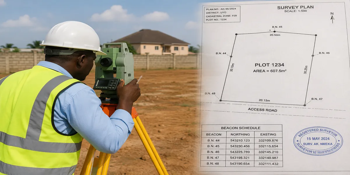
If you are looking at a survey plan right now and wondering what those small numbers at the corners of your land mean, here is the direct answer: a beacon number is the unique identification number assigned to each concrete or iron pillar (called a beacon) planted at the corner points of your land, marking exactly where your boundary begins and ends. These numbers are recorded on your survey plan and in the surveyor-general’s records, and they are one of the most important tools you have for proving where your land physically sits on the ground.
Now let’s go deeper, because understanding this properly can genuinely protect you from losing money, land, or peace of mind.
Why This Small Number Matters More Than Most Buyers Realize
In my experience, most land buyers focus heavily on the title document and almost ignore the beacon numbers entirely. This is one of the most common misconceptions I encounter people assume a survey plan is just paperwork, when it is actually a physical, verifiable record of your land’s exact position and shape. Based on projects I have worked on, disputes rarely happen because someone didn’t have a survey plan. They happen because beacons were never checked, were moved, or simply went missing, and nobody noticed until a conflict started.
Survey Plan Fundamentals: What You’re Actually Looking At
A survey plan is a scaled drawing, prepared and signed by a licensed surveyor, that shows the exact size, shape, and location of a piece of land. It is not the same as a title document a title tells you who legally owns the land; a survey plan tells you exactly where that land is and what shape it takes on the ground.
A properly prepared survey plan typically includes:
- Survey/Plan Number: A unique reference number for that specific plan, used for record-keeping and verification.
- Coordinates: Precise positional values (Easting and Northing) for each corner point of the land, tied to a national coordinate system.
- Bearings: The direction of each boundary line, expressed in degrees, showing how the boundary runs from one beacon to the next.
- Distances: The measured length of each boundary line, usually in meters.
- Beacon Numbers: The unique ID assigned to each physical pillar marking a corner of the land.
- Parcel Identification: Details linking the plan to a specific parcel within a layout, registered scheme, or local government area.
What Exactly Is a Beacon, and What Does the Number Mean?
A beacon is a physical marker usually a concrete pillar with an embedded metal tag, or sometimes an iron pipe planted firmly into the ground at each corner of a piece of land. The beacon number stamped or recorded for that pillar corresponds directly to a coordinate position recorded in the surveyor’s field data and on the survey plan.
In practical terms, what usually happens is this: a surveyor visits the site, takes precise measurements using GPS or total station equipment, calculates the exact corner positions, and then physically plants a beacon at each corner. Each beacon is given a number, and that number is cross-referenced on the survey plan so that anyone you, a lawyer, a government official, or a future buyer can go back to that exact spot on the ground and confirm the land’s true boundary, even years later.
Expert Note: During field inspections, I discovered that many land disputes could have been avoided entirely if the parties involved had simply gone back to the beacon numbers on their survey plans and physically located those pillars before building or selling. The beacon number is your reference point it is what ties the paper drawing to the actual ground.
How Beacon Numbers Support Land Ownership Verification
A survey plan, and the beacon numbers on it, support your ownership claim in several important ways:
- Physical proof of boundary: Unlike a title document, which is a legal claim, beacon numbers give you a physical, locatable reference on the ground.
- Cross-referencing at the surveyor-general’s office: Beacon numbers and coordinates can be checked against official records to confirm a plan is genuine and matches registered data.
- Protection during resale: When you eventually sell, a buyer’s surveyor can independently verify your boundaries using the same beacon numbers, building trust and reducing disputes.
It’s important to understand the limitation here too: a survey plan confirms location and shape, but it does not by itself confirm legal ownership. You still need proper title documentation. The two work together one proves where the land is, the other proves who owns it.
Boundary Issues: Where Beacon Numbers Become Critical
This is where I have seen the most painful situations play out.
Missing or Moved Beacons
While working on site plans, I noticed that beacons frequently go missing over time — sometimes removed during farming activities, sometimes deliberately shifted by a dishonest neighbor trying to encroach on adjoining land, and sometimes simply lost to erosion or construction activity nearby. When a beacon is missing, the beacon number and coordinates on your survey plan become your lifeline a licensed surveyor can use that recorded data to re-locate and replant the beacon in its exact original position.
Encroachment Problems
I have seen this mistake repeatedly: a neighbor gradually builds a fence or wall slightly over the boundary line, often starting small enough that it goes unnoticed for months or years. Once beacons are missing, proving the original boundary becomes much harder without a proper resurvey referencing the original beacon numbers and coordinates.
Family Land and Neighbor Disputes
One challenge I repeatedly encountered involves family land that was never formally surveyed and beaconed when it was first divided among siblings or relatives. Without clear, numbered beacons, informal boundary agreements between family members can be reinterpreted differently by different generations — a recipe for prolonged and often bitter disputes.
Government Acquisition Issues You Need to Understand
Before buying or building on any land, you must check whether it falls under any form of government acquisition, because this affects what you can legally do with it, regardless of what your survey plan or title says.
- Government Acquisition: Land that has been formally taken over by government for public use or future development.
- Committed Acquisition: Land already earmarked or allocated for a specific government project, even if not yet developed.
- Global Acquisition: A broad, large-scale acquisition covering extensive land areas, often affecting multiple communities or layouts at once.
- Excision: A portion of previously acquired land that has been officially released back for private or community use.
- Gazette: The official government publication that legally announces and records acquisitions, excisions, and other land status changes.
- Free Areas: Land that is not under any government acquisition and is generally available for private ownership and development, subject to normal title processes.
From a planning perspective, I strongly recommend checking a property’s acquisition status at the relevant land bureau or ministry before any money changes hands a survey plan alone will not reveal this information.
Fraud Prevention: Warning Signs Every Buyer Should Know
Land fraud is one of the most damaging risks in property transactions, and beacon-related fraud is more common than most buyers expect.
Common Scams to Watch For
- Fake or altered survey plans: Documents with coordinates or beacon numbers that don’t match official records.
- Multiple sales of the same plot: The same land sold to several buyers, often before beacons are even physically checked by any of them.
- Forged coordinates: Numbers that look official but don’t correspond to any registered survey data.
- Beacon substitution: Deliberately pointing buyers to the wrong physical beacons on site to misrepresent the actual plot boundaries.
Warning Signs Buyers Should Notice:
- The seller is reluctant to let you bring your own independent surveyor to verify beacons on-site.
- Beacon numbers on the plan don’t match any pillars physically visible on the ground.
- The survey plan has no clear surveyor’s signature, stamp, or registration number.
- Coordinates look inconsistent or oddly rounded compared to typical survey data.
- Pressure to “pay first, verify later.”
This is not just theory. I have seen it happen: buyers who skipped independent verification and later discovered the beacons on the ground didn’t match their paperwork at all sometimes because they were shown the wrong plot entirely.
The Surveying Process: How Beacons Actually Get Placed
Understanding the process helps you know what proper due diligence looks like:
- Site inspection: The surveyor visits the land to understand its physical context and existing features.
- Field measurements: Using GPS or total station equipment, the surveyor captures precise coordinate data for each corner point.
- Beacon placement: Concrete or iron beacons are physically planted at each measured corner, each assigned its unique number.
- Data processing: Field data is processed to produce accurate bearings, distances, and coordinates.
- Survey drafting: A formal survey plan is drafted, showing all beacon numbers, coordinates, bearings, and distances.
- Submission: The completed plan is submitted to the relevant surveyor-general’s office for registration and record-keeping.
Survey Plans in Building and Development
Your survey plan and its beacon data feed directly into your building process:
- Building approval: Most building approval authorities require an authenticated survey plan before approving architectural drawings, since your building design must sit correctly within your verified boundary.
- Architectural drawings: Architects and designers use your survey plan’s exact dimensions to position the building footprint correctly on the plot.
- Setback compliance: Beacon-verified boundaries determine exactly where setback distances are measured from, ensuring your building doesn’t violate spacing regulations.
- Plot utilization: Knowing your true, beacon-confirmed boundary helps maximize usable space without accidentally building over the line.
During a design review, I once handled a project where the client’s building footprint had to be adjusted at the last stage because a resurvey revealed the original beacons had shifted slightly from where the client assumed. Confirming beacon positions early saved that project from a much costlier correction after construction had started.
Cost and Practical Considerations
Survey plan costs vary based on several factors:
- Plot size: Larger or irregularly shaped plots typically cost more to survey.
- Location and accessibility: Remote or difficult-to-access sites may increase costs.
- State and jurisdiction: Survey and registration fees differ from one state or authority to another.
- Resurveying needs: Replacing missing beacons or resolving boundary disputes adds additional cost beyond a standard survey.
Common hidden expenses to budget for include beacon replacement fees, registration and gazette-related charges, and costs associated with resolving discrepancies discovered during verification.
GIS and Modern Surveying: How Technology Is Changing Beacon Verification
Modern surveying increasingly relies on GPS surveying, GIS mapping, and digital survey records, making it easier to cross-check beacon coordinates against centralized digital databases rather than relying solely on paper plans. Drone surveys are also becoming more common for larger sites, capturing detailed aerial data that complements ground-based beacon verification. This shift toward geospatial technology means fraud is becoming easier to detect for buyers who know to ask for digital coordinate verification, not just a paper plan.
Investment and Property Security: Protecting Your Money
Having seen the consequences of skipped verification, here is the practical advice I give every prospective buyer:
- Always engage an independent, licensed surveyor to verify beacon numbers and coordinates before completing any purchase.
- Physically walk the land and confirm each beacon is present, undisturbed, and matches the plan.
- Cross-check the survey plan and beacon data against records at the relevant surveyor-general’s office.
- Treat proper verification as part of your investment cost, not an optional extra — it is significantly cheaper than a legal dispute later.
Quick Summary / Practical Checklist
Before finalizing any land purchase, confirm:
- The survey plan has a valid surveyor’s signature, stamp, and registration number.
- Beacon numbers on the plan correspond to physical beacons you can locate on-site.
- Coordinates have been independently verified, not just taken on the seller’s word.
- The land’s acquisition status (free area, gazetted, excised, etc.) has been confirmed.
- Title documentation aligns properly with the survey plan.
Frequently Asked Questions
What is a beacon number on a survey plan?
It is the unique identification number assigned to a physical pillar marking a corner point of a piece of land, corresponding to specific coordinates recorded on the survey plan.
Can I buy land if a beacon is missing?
You can, but you should have a licensed surveyor relocate and replant the beacon using the recorded coordinates before finalizing the purchase, to avoid future boundary disputes.
Does a survey plan prove ownership?
No. A survey plan proves the size, shape, and location of land. Ownership is proven through proper title documentation, which should align with the survey plan.
How do I verify a survey plan is genuine?
Cross-check the survey/plan number, beacon numbers, and coordinates against records at the relevant surveyor-general’s office, and engage an independent surveyor to confirm beacons physically match the plan.
Why do boundary disputes happen even with a survey plan?
Most disputes happen when beacons go missing, get moved, or are never physically checked against the plan over time the paper plan alone doesn’t prevent a dispute if nobody verifies the ground reality.
Finally
I have encountered this situation multiple times: the difference between a smooth land transaction and a years-long legal battle almost always comes down to one thing whether someone took the time to verify the beacon numbers and coordinates against the physical ground before money changed hands. This observation comes from practical field experience, not assumption. Treat your beacon numbers as seriously as you treat your title documents, because together, they are what protect your investment.
If you’re preparing to build on land you’ve just verified, our plans library has ready-made designs across different plot sizes, and our plan school covers more foundational planning topics like this one. If you need professional support verifying a survey plan or preparing your building documentation, our design services can help directly. Start from our homepage to explore everything else we offer.
Related articles for more clarity
- Survey Plan vs Deed of Assignment in Nigeria: The Complete Difference Explained
- Survey Plan Symbols and Numbers Explained in Nigeria: A Complete Guide for Land Buyers
- Nigerian Building Approval Checklist for Overseas Property Owners
- Lost Survey Beacon in Nigeria: What to Do, Replacement Cost, and Legal Process
- How to Verify Land Ownership Using GIS and Survey Records
- How to Read a Survey Plan in Nigeria Without Hiring an Expert
- Survey Plan Cost in Nigeria: Fees, Process and Hidden Expenses
- What Is a Survey Plan and Why Do Property Owners in Nigeria Need One?
- Town Planning Services: Plans, Permits and Land Development
- AutoCAD House Plan Tutorial for Beginners: Learn to Draw Plans Step by Step
- How to Draw a Roofing Plan Step by Step (Manually and in AutoCAD): Complete Guide with Practical Examples
- How to Draw a Building Plan Section A-A, B-B: Step by Step Complete Beginner’s Guide
- How to Draw Building Elevations Step by Step (Manually and in AutoCAD): Complete Guide for Beginners