Don’t Sign That Land Deal Until You Can Read This One Document

Boundary beacon placement during a site survey in South-South Nigeria
If you are holding a survey plan right now, here is the short answer: you can read it yourself, in about ten minutes, by checking five things, the survey number, the coordinates, the beacon positions, the acquisition status, and the registered owner’s name. You do not need a town planning degree to do this. You need to know where to look on the document and what each section is telling you. That is exactly what this guide will show you, step by step, using the same checks I use when I assess land for clients across Akwa Ibom, Rivers, and Cross River States.
Every year, Nigerians lose money on land that looked fine on paper but was sitting inside a government acquisition zone, or had coordinates that did not match the physical plot, or carried a survey plan that was never registered at all. In my experience, almost none of these buyers were careless people. They simply did not know what to look for, because nobody ever showed them how a survey plan is actually structured.
I want to changes that in this article. By the end, you will be able to pick up any Nigerian survey plan, your own, or one a seller hands you and tell within minutes whether it is genuine, current, and safe to build your investment on.
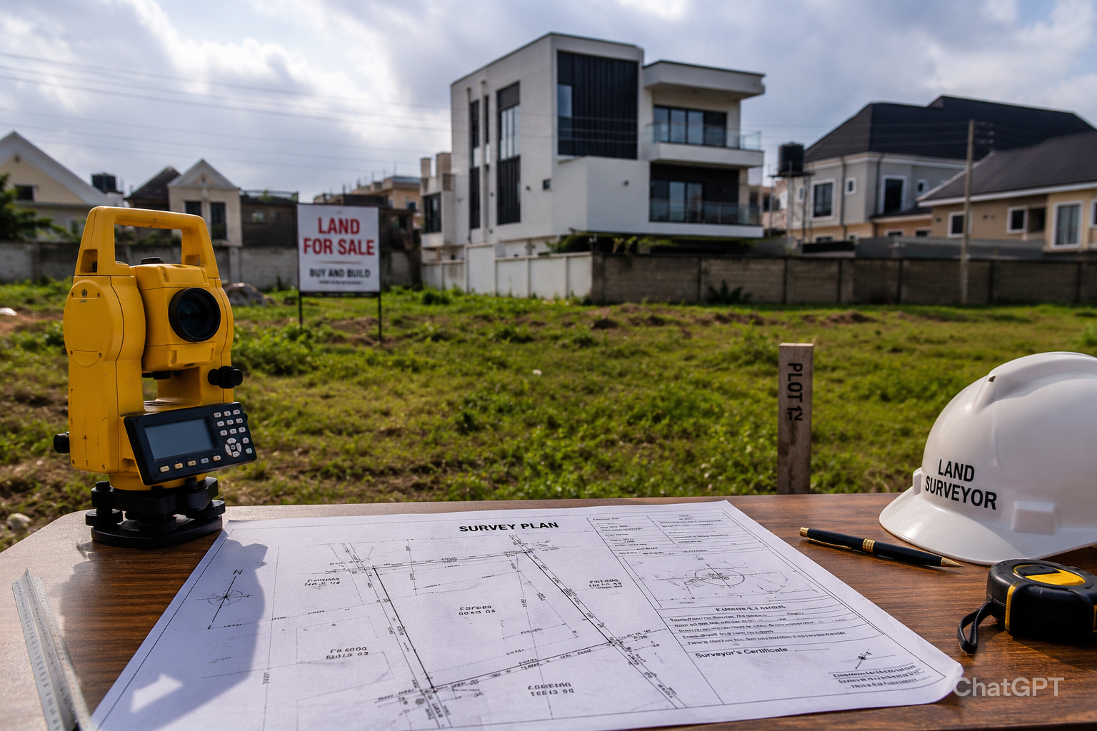
What a Survey Plan Actually Is (And Why It Is Not Optional)
A survey plan is a scaled, technical drawing prepared by a licensed surveyor that shows the exact size, shape, position, and boundaries of a piece of land, tied to the national grid coordinate system. It is the document that answers the question every land buyer should ask first: “Where exactly does this land start and end?”
A Certificate of Occupancy or a Deed of Assignment tells you who owns land. A survey plan tells you precisely which land they own. Both documents work together, but they are not the same thing, and one without the other leaves you exposed.
During my internship, I observed that the single biggest source of confusion for first-time land buyers in Uyo and Port Harcourt was assuming that having a Deed of Assignment meant the boundaries were settled. It does not. The survey plan is what settles the boundaries.
The Core Components of a Nigerian Survey Plan
Every authentic survey plan in Nigeria carries the same structural elements, regardless of which state issued it. Once you can identify these six items, you can read any survey plan placed in front of you.
1. The Survey Plan Number
Found at the top right or bottom right of the drawing, this is a unique reference code (for example, AK/12345) that ties the plan to the state Surveyor-General’s registry. This number is what allows the plan to be verified at the Ministry of Lands. A survey plan without a clear, traceable number is the first warning sign of a problem.
2. Coordinates
Each beacon position on the plan is expressed as Northing and Easting values, tied to the Nigerian Transverse Mercator (Minna Datum) or, increasingly, the UTM/WGS84 system used in newer GIS-based surveys. These coordinates are what allow the exact location of the land to be reproduced on the ground at any time, by any licensed surveyor, without needing to ask the original owner where the boundary is.
3. Bearings and Distances
Bearings describe the direction of each boundary line (expressed in degrees, minutes, and seconds), while distances give the length of each side in metres. Together, bearings and distances let you calculate whether the stated land size genuinely matches the shape drawn on the plan.
This observation comes from practical field experience: I have seen plans where the bearings and distances on paper do not close into a proper geometric shape when checked. That mismatch usually means the plan was redrawn from an old template rather than from an actual field survey.
4. Beacon Information
Beacons are the physical concrete pillars (or in some newer surveys, buried iron pins) placed at each corner of the land. The survey plan lists a beacon number for every corner. When you visit the site, these numbers should match physical beacons you can see, touch, and count.
5. Parcel Identification and Locality
This section names the layout, scheme, or area (for example, “Ikot Ekpene Road Layout” or “Shelter Afrique Estate”) and states the Local Government Area. It should match the address you were given by the seller, word for word.
6. Area in Hectares or Square Metres
The total land area is stated clearly, usually in the bottom section of the plan. This is the figure you compare against what you were verbally told, and against what the bearings and distances calculate to.
Step-by-Step: How to Read Your Survey Plan in 10 Minutes
Follow this sequence every time, in this order. Skipping a step is how problems get missed.
- Locate the survey plan number and confirm it is legible, not smudged, and not handwritten over a printed template.
- Check the surveyor’s name, signature, and seal/stamp number against the public list of NIS (Nigerian Institution of Surveyors) registered surveyors for that state.
- Read the coordinates for each beacon and note how many beacons are listed this should match the number of corners the land actually has.
- Check the acquisition remarks section (usually a small note near the bottom or a coloured shading) for any indication the land falls within a government acquisition, committed acquisition, or excision area.
- Compare the named locality and Local Government Area on the plan with the address given to you in writing.
- Confirm the area (in hectares or square metres) matches what was verbally promised.
- Cross-check the plan against the title document (C of O, Deed of Assignment, or Excision) to confirm the names, parcel description, and survey number are consistent across both documents.
Surveyor’s Practical Layer
While working on site plans, I noticed that the fastest way to catch a problem is to read the survey plan and the title document side by side, not separately. A survey plan that looks perfect on its own can still describe a completely different parcel from the one named in the Deed of Assignment. I have encountered this situation multiple times, usually where the same plan number was reused across two unrelated sales.
Government Acquisition: The Issue Most Buyers Never Check
This is, in my experience, the most expensive mistake a land buyer can make in Nigeria, because the land can have a perfectly genuine survey plan and a perfectly genuine seller, and still be unbuildable because government has already taken an interest in it.
Types of Acquisition You Need to Recognise
- Government Acquisition, land formally acquired by federal, state, or local government for public use (roads, institutions, reserves).
- Committed Acquisition, land earmarked for a specific declared government project, even if construction has not started.
- Global Acquisition, a broad designation covering large tracts, common around government house areas, airports, and military zones.
- Excision, a portion of previously acquired land that government has released back to the original community or family for private allocation.
- Gazette, the official government publication that legally records an acquisition; if a gazette exists for an area, it overrides informal assurances from a seller.
- Free Area, land confirmed to be outside any acquisition, the status every buyer should be aiming to confirm in writing.
During field inspections, I discovered that many sellers genuinely do not know their land sits within a committed acquisition, because the acquisition may predate their own purchase by decades. This is not always deliberate fraud but it is always your financial risk if you do not check.
Nigerian Reality Layer
Across Akwa Ibom, Rivers, and Cross River States, large areas around government layouts, military formations, and airport corridors carry acquisition status that is not obvious from looking at the land itself. A plot can be fenced, occupied by neighbours, and actively sold and still legally belong to government. The only way to know for certain is a search at the relevant Ministry of Lands and Survey, referencing the survey plan number.
Boundary Disputes, Encroachment, and Missing Beacons
A survey plan is only useful if the boundaries it describes still exist and are respected on the ground. Three boundary problems come up repeatedly in Nigerian land transactions.
Missing or Disturbed Beacons
Beacons get removed, buried under new construction, or shifted by neighbours expanding their own fences. If you visit a site and cannot locate the beacons listed on the survey plan, do not assume they are simply hidden commission a re-survey before you pay anything further.
Encroachment
This happens when a neighbouring structure, fence, or farm extends past its legal boundary into the land you are buying. A site inspection with the survey plan and a surveyor present is the only reliable way to catch this before you take possession.
Family Land Conflicts
I have seen this mistake repeatedly: land sold by one member of a family without the documented consent of co-owners, where the survey plan itself is genuine but the underlying ownership is contested. The plan will not warn you about this it only describes the land’s boundaries, not who has the right to sell it. This is why title verification at the family or community level matters as much as the survey plan itself.
Neighbour Disputes Over Setbacks
Where two adjoining survey plans were prepared years apart, small overlaps sometimes appear due to instrument drift or re-surveying with different reference points. A licensed surveyor can resolve this through a comparative re-survey, but it is far cheaper to identify before construction begins than after.
Fake Survey Plans and the Warning Signs Buyers Miss
Survey plan fraud in Nigeria typically takes one of four forms. Knowing them in advance is your best protection.
| Fraud Type | How It Works | Warning Sign |
| Forged coordinates | Genuine-looking plan with coordinates copied or altered from another parcel | Coordinates do not match physical site when checked with GPS |
| Multiple sales | Same plot sold to several buyers using duplicated or reused survey numbers | Survey number search at Ministry shows conflicting allocation records |
| Fake surveyor stamp | Plan stamped with a forged or expired NIS seal | Surveyor’s name not found on the NIS or SURCON public register |
| Recycled old plans | Old, outdated survey plan reused for a different, larger, or relocated parcel | Area or shape on plan does not match the actual site boundaries |
Five Things to Verify Before You Pay a Kobo
- The survey plan number exists in the state Ministry of Lands and Survey records.
- The surveyor’s registration is active with the Surveyors Council of Nigeria (SURCON).
- The acquisition status search comes back as a free area, in writing.
- The names on the survey plan match the names on the title document exactly.
- A physical site inspection confirms the beacons match the coordinates on paper.
Based on projects I have worked on, buyers who insist on all five checks before paying any deposit almost never end up in a land dispute. Buyers who skip even one, particularly the Ministry search, are the ones who call asking for help after the money has already changed hands.
How a Survey Plan Is Actually Produced
Understanding the production process helps you judge whether a plan in your hand looks legitimate or rushed.
- Site Inspection — the surveyor visits the land to identify existing beacons, access points, and adjoining boundaries.
- Field Measurements — using GPS receivers and/or total stations, the surveyor records precise coordinates for every corner.
- Beacon Placement — concrete or iron beacons are set at each corner and numbered to match the field data.
- Data Processing — raw field data is processed and checked for closure (the boundary lines must mathematically form a closed shape).
- Survey Drafting — the final plan is drawn to scale, with coordinates, bearings, distances, and parcel details.
- Submission — the completed plan is submitted to the state Surveyor-General’s office for vetting and registration, after which it receives an official survey number.
One lesson I learned early is that a survey plan that has not been submitted and registered with the Surveyor-General’s office is not yet a complete legal document, no matter how professional it looks. Always confirm registration status, not just that a surveyor produced the drawing.
Survey Plans, Building Approval, and Architectural Drawings
Once land is verified, the survey plan becomes the foundation document for everything that follows in development.
- Building approval applications at the state Ministry of Physical Planning require the registered survey plan as a base attachment.
- Architectural and structural drawings are set out using the exact boundary coordinates from the survey plan, so the building sits correctly within the plot.
- Site planning and setback compliance — the distance your building must keep from each boundary — are measured directly from the survey plan’s beacon positions, not estimated by eye.
- Plot utilization (how much of the land you can legally build on, often expressed as a coverage ratio) is calculated against the area stated on the survey plan.
Based on projects I have worked on, incorrect setbacks traced back to an inaccurate or outdated survey plan are one of the most common causes of building approval rejection in Nigerian cities. Getting the survey plan right at the start saves weeks of delay later in the architectural and approval stages.
Construction Reality Layer
A survey error of even half a metre can shift a building’s setback out of compliance, trigger a stop-work order from physical planning enforcement, or place a fence directly on a neighbour’s beacon. I have seen foundation work halted because a contractor built from an old, unregistered survey plan instead of the current registered one. Always work from the most recently registered plan, not the one the family has kept since the 1990s.
Survey Plan Costs in Nigeria: What Affects the Price
Survey plan costs vary significantly across Nigeria, and understanding what drives the price helps you avoid being overcharged or underquoted in a way that signals corner-cutting.
| Factor | Effect on Cost |
| Plot size | Larger parcels require more field time and beacon placement, raising cost |
| State and locality | Urban centres like Lagos and Port Harcourt typically cost more than rural plots in the same state |
| Terrain and access | Swampy, bushy, or hard-to-reach land increases field survey time and cost |
| Urgency | Rush jobs requiring same-week registration often carry a premium |
| Registration and search fees | Separate from the surveyor’s professional fee, these are paid directly to the Ministry of Lands and Survey |
Common Hidden Expenses
- Ministry verification and search fees, charged separately from the surveyor’s fee
- Re-survey costs if original beacons cannot be located on site
- Gazette confirmation fees where acquisition status needs formal written clearance
- Charting fees for registering the plan against the state base map
Always request an itemised quotation before work begins, so these costs are not presented as surprises after the survey is complete.
GIS, GPS, and the Future of Land Verification in Nigeria
Survey practice in Nigeria is shifting steadily from purely manual chain-and-compass methods toward GPS and GIS-based approaches, and this shift directly affects how reliable a survey plan is.
- GPS Surveying, satellite-based positioning that produces coordinates accurate to within centimetres, replacing older theodolite-only methods.
- GIS Mapping, geographic information systems that store land parcel data digitally, making it easier (where state registries have digitised) to cross-check survey plans against official records.
- Digital Surveys, field data captured electronically and processed through specialised software, reducing manual transcription errors.
- Drone Surveys, increasingly used for large estates and master-planned developments, producing high-resolution aerial data that supplements ground survey work.
In my experience, states and registries that have moved toward digitised GIS records make verification significantly faster for buyers, because a survey plan number can sometimes be checked against a digital parcel map rather than relying solely on physical archive search. Where this digital infrastructure exists, use it, it adds a layer of cross-verification that paper records alone cannot offer.
Protecting Your Investment: Due Diligence Beyond the Survey Plan
A correctly read survey plan is the foundation of due diligence, not the entirety of it. Pair it with these additional steps before committing funds.
- Conduct a search at the Ministry of Lands and Survey using the survey plan number.
- Request the original title document and confirm it references the same survey plan number.
- Visit the site in person with the survey plan and, where possible, a licensed surveyor.
- Confirm there is no pending litigation attached to the parcel, where court registry searches are accessible.
- Get all acquisition and free-area confirmations in writing, on letterhead, not verbally.
- Keep certified true copies of every document, including the survey plan, in a secure, separate location from the originals.
Investment Protection Layer
This is not just theory. I have seen it happen: buyers who paid full price for land, only to discover during building approval processing that the survey plan referenced a different acquisition status than what was verbally promised. The cost of a proper Ministry search, typically a small fraction of the land price, is the cheapest insurance available in Nigerian real estate. Skipping it to save that fee is the single most common regret I hear from clients after the fact.
Quick Summary: What to Check on Any Survey Plan
- Survey plan number is clear, legible, and traceable to the state Ministry of Lands and Survey
- Surveyor’s name and seal appear on the SURCON/NIS public register
- Coordinates and beacon numbers match what you find on a physical site visit
- Acquisition status is confirmed as free area, in writing
- Stated area matches both the bearings/distances calculation and what you were told verbally
- Names on the survey plan match the title document exactly
- The plan is registered, not just drawn
Common Mistakes Buyers Make With Survey Plans
- Trusting a survey plan without checking it against the title document
- Assuming a fenced, occupied plot cannot be under government acquisition
- Skipping the Ministry of Lands and Survey search to save money or time
- Relying on a survey plan older than ten years without confirming the beacons still exist
- Not involving a licensed surveyor for the physical site inspection before payment
Frequently Asked Questions
Can I verify a survey plan myself without hiring a surveyor?
Yes, for the initial checks plan number legibility, coordinate presence, acquisition remarks, and matching names against your title document. However, the physical site verification of beacon positions against coordinates should ideally involve a licensed surveyor, since this requires survey instruments for full accuracy.
What does it mean if a survey plan has no acquisition remark at all?
The absence of an acquisition remark does not automatically mean the land is free from government acquisition. Request written confirmation from the Ministry of Lands and Survey instead of relying solely on the survey plan because acquisition status may change after the surveyor prepares the plan.
How long does a survey plan remain valid?
A survey plan does not technically expire. However, beacons may disappear, get damaged, or shift over time, and acquisition status may also change. If the plan is more than five to ten years old, conduct a site re-verification before you rely on it for a land purchase.
What is the difference between a survey plan and a Certificate of Occupancy?
The survey plan describes the physical boundaries and location of the land. The Certificate of Occupancy is the title document confirming the right of occupancy granted by government. You need both, and they must reference the same survey plan number and parcel description.
Can two different survey plans exist for the same plot of land?
This should not happen with properly registered plans, but it does occur in fraud cases involving multiple sales. A Ministry search using the survey plan number is the most reliable way to detect this before you commit funds.
Final Word: Read Before You Sign
A survey plan is not a decorative document that comes attached to land for formality’s sake. It is the single most precise tool you have for confirming exactly what you are paying for, where it sits, and whether it is safe to build your future on. Reading it correctly, in the order covered in this guide, takes minutes and can save you years of legal and financial difficulty.
Before you make your next land purchase, verify the survey plan number, confirm the acquisition status in writing, and walk the actual boundaries against the coordinates on paper. These steps protect your money far more effectively than trust alone ever will.
If you are preparing to buy land, process documentation, or need a professional verification and survey plan review for a property anywhere in Akwa Ibom, Rivers, Cross River, Lagos, or Abuja, MassodihPlans offers direct, experience-based support for exactly this kind of due diligence.
Continue Learning on MassodihPlans
Explore related guidance: Estate Layout Plans and Design in our Plans Library.
Understand the building process from the ground up in Plan School.
Need a professional land or survey plan review? Visit our Services page to get started.
Return to the MassodihPlans homepage for more trusted planning and architectural guidance.
For official verification procedures, the Surveyors Council of Nigeria (SURCON) maintains the public register of licensed surveyors.