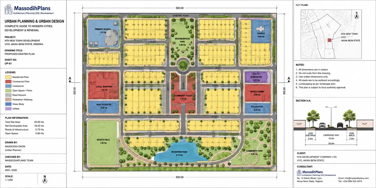
Urban Planning, Design and Renewal
Introduction to Urban Planning & Urban Design: Complete Guide to Modern Cities, Development and Renewal
Urban planning is the process of deciding how land, buildings, roads, infrastructure, public spaces, housing, transport, services, and environmental systems should work together to create safe, functional, attractive, and sustainable cities. Urban design takes that planning a step further by shaping how streets, buildings, parks, neighborhoods, and public spaces look, connect, and function in everyday life. Together, urban planning and urban design determine not only where development happens, but also how people move, live, work, interact, and experience a city.
A successful city does not happen simply because buildings are constructed on available land. It requires decisions about land use, zoning, density, transportation, infrastructure, housing, drainage, green spaces, economic activity, environmental protection, and future growth. When these elements are planned independently, cities can develop congestion, inadequate drainage, uncontrolled expansion, housing shortages, unsafe streets, and inefficient infrastructure.
This complete guide takes you beyond the basic definition of urban planning. You will discover how modern cities are planned, how urban design influences development, how land development decisions are made, how master plans and zoning work, and how infrastructure and public spaces shape urban growth.
You will also explore the practical relationship between urban planning, architecture, landscape design, surveying, transportation planning, environmental management, stormwater management, and property development.
Most importantly, this guide examines what happens when cities need to change. From urban renewal and neighborhood regeneration to redevelopment, sustainable growth, climate resilience, smart-city planning, and historic preservation, you will see how planners and designers can transform existing urban areas without losing their identity.
Whether you are a property owner, developer, student, architect, planner, investor, government professional, or simply someone interested in how cities work, this guide provides a complete framework for understanding the decisions that shape the places where millions of people live.
What is Urban Renewal
Every city carries within it neighborhoods that time has not been kind to. Walk through the older quarters of Lagos, Port Harcourt, or Uyo, and you’ll find streets where the infrastructure has outlived its intended lifespan, where buildings that once housed thriving families and businesses now sit half-abandoned, and where the gap between what a place could be and what it has become grows wider each year. This is the terrain of urban renewal, and it remains one of the most consequential and most contested practices in modern city-building.
At its core, urban renewal is the deliberate transformation of underperforming or deteriorated urban areas through demolition, reconstruction, infrastructure upgrades, and land-use reorganization. It is a planning intervention aimed at reversing decline: replacing collapsed drainage systems, rebuilding failing road networks, clearing blighted structures, and reintroducing the kind of order that allows a neighborhood to function again. Unlike routine maintenance, urban renewal operates at scale. It is not about patching a pothole or repainting a facade; it is about rethinking how an entire district works, often from the ground up.
Origin of Urban Renewal
The origins of formal urban renewal trace back to the mid-twentieth century, when rapidly industrializing cities across Europe and North America grappled with slum clearance, war damage, and the fallout of unmanaged growth. Governments intervened aggressively, often bulldozing entire districts to make way for new housing blocks, highways, and civic infrastructure. The results were mixed at best. While some renewal projects genuinely improved living conditions, others displaced long-standing communities, severed social networks, and replaced organic, walkable neighborhoods with sterile developments that never quite earned the affection of the people who lived there. That history matters, because it shaped how planners today approach renewal with far more caution and community sensitivity than their predecessors did.
Nigerian Context of Urban Renewal
In the Nigerian context, and across much of the developing world, urban renewal takes on additional urgency. Cities here are expanding faster than their planning frameworks can accommodate. Informal settlements grow around formal city cores, drainage and sanitation infrastructure lags behind population density, and building stock ages without the maintenance regimes that might extend its useful life. Areas of Port Harcourt’s older waterfront districts, sections of Lagos Island, and pockets of Uyo’s original layout illustrate this pattern clearly: places that were once well-planned and functional now strain under decades of deferred investment, informal expansion, and inconsistent enforcement of building codes.
A well-executed urban renewal strategy typically moves through several deliberate phases. It begins with a rigorous assessment cataloguing the condition of buildings, mapping infrastructure deficits, and understanding the social and economic fabric of the area in question. This is not a step to rush. Renewal that skips proper assessment tends to misallocate resources, targeting cosmetic fixes while ignoring structural failures like inadequate stormwater management or unstable foundations in flood-prone zones. From there, planners typically define intervention priorities: which structures require demolition versus rehabilitation, which roads need full reconstruction versus resurfacing, and which utility networks water, power, sewage need complete overhaul rather than incremental repair.
Financing Urban Renewal
Financing is where many renewal ambitions stall. Large-scale renewal is capital-intensive, and in contexts where municipal budgets are constrained, public-private partnerships have become a common mechanism for unlocking investment. Developers gain access to land in central, often high-value locations; in exchange, they commit to delivering public infrastructure, affordable housing components, or civic amenities alongside their commercial developments. When structured well, this model can accelerate renewal without placing the entire financial burden on government. When structured poorly, it can lead to renewal that serves investor interests far more than the residents the project was ostensibly meant to help a criticism that has trailed many renewal schemes globally, and one that Nigerian planning authorities are increasingly alert to as they draft new urban development frameworks.
This is where the ethical dimension of urban renewal becomes unavoidable. Displacement is the single most persistent controversy attached to renewal projects. When a deteriorated neighborhood is cleared for redevelopment, the people who lived there often low-income residents with deep social ties to the area frequently cannot afford to return once the new development is complete. This dynamic, sometimes called renewal-induced gentrification, has prompted a shift in planning philosophy over the past two decades. Rather than wholesale clearance, many planners now favor incremental, in-situ renewal: upgrading infrastructure and housing stock while keeping existing residents in place, offering relocation only where structural safety genuinely demands it, and building in affordable housing quotas as a non-negotiable component of any renewal masterplan.
Successful renewal Strategy
Successful renewal, then, is not simply a technical exercise in demolition and reconstruction. It requires genuine engagement with the communities who will live with the outcome public consultations, transparent compensation frameworks for displaced residents, and phased implementation that doesn’t destabilize a neighborhood’s social and economic life all at once. The most respected renewal projects, from Barcelona’s Ciutat Vella regeneration to more localized African examples, share a common thread: they treat existing residents as stakeholders in the outcome rather than obstacles to be cleared out of the way.
Urban renewal, in this sense, is never purely about buildings and infrastructure. It’s about who gets to remain part of a city’s future as that future is being built. And that question becomes even more pointed when the deteriorating structures in question aren’t just ordinary buildings, but ones that carry historical, architectural, or cultural weight the kind of buildings a city cannot simply demolish and replace without losing something irreplaceable. That distinction is precisely where urban renewal gives way to a closely related but distinct discipline: historic preservation.
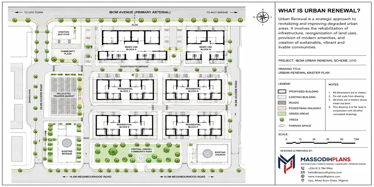
Urban Renewal Plans: Urban Planning & Urban Design
Historic Preservation
So here’s the thing about old buildings not every deteriorating structure deserves the bulldozer treatment we just talked about. Some buildings carry something you can’t rebuild: a story, a craftsmanship, a piece of collective memory that belongs to everyone who’s ever walked past it. That’s the whole premise behind historic preservation, and it’s worth slowing down to really understand because it’s easy to confuse with renewal when actually the two operate on almost opposite instincts.
What Historic Preservation Actually Means
Think of it this way: renewal asks “how do we fix or replace what’s broken?” Preservation asks “how do we protect what’s irreplaceable?” It’s the practice of identifying, protecting, and maintaining buildings, districts, monuments, and sites that hold architectural, cultural, or historical significance. This isn’t nostalgia for its own sake. A colonial-era trading post in Calabar, a mid-century civic building in Lagos, or a traditional Efik compound in Old Calabar tells you something about how a place came to be its trade routes, its colonial encounters, its indigenous building traditions. Once that structure is gone, that knowledge doesn’t transfer to a plaque or a photograph the same way it lives in the actual walls.
How a Building Earns Protected Status
You might wonder who decides what’s worth saving? Usually it comes down to a mix of criteria: age, architectural distinctiveness, association with significant historical events or people, and rarity. A building doesn’t need to be centuries old to qualify; a well-preserved example of 1960s modernist design can matter just as much as a nineteenth-century structure, if it represents something otherwise disappearing from the urban fabric. In most functioning planning systems, this recognition comes through a formal listing or designation process a heritage register, a national monuments commission, or a state-level conservation authority. Once listed, the building typically falls under legal protection, meaning alterations, demolition, or even certain repairs require approval from a heritage body before work can begin.
The Preservation Toolkit
Now, preservation isn’t a single technique it’s really a spectrum of interventions, and knowing which one applies where matters a lot. On one end you’ve got restoration, which means returning a building as closely as possible to its original appearance, often using period-accurate materials and techniques. This is painstaking, expensive work think of restoring original timber joinery or replicating lost decorative plasterwork. Further along the spectrum is rehabilitation, which allows for more flexibility: you keep the character-defining features intact but make reasonable updates so the building can function for modern use, like adding electrical wiring or plumbing without disturbing the facade. Then there’s conservation in the broader sense, which is more about ongoing maintenance and protective measures to slow deterioration rather than reversing it entirely. Each approach has its place depending on the building’s condition, its significance, and what it’s actually going to be used for going forward.
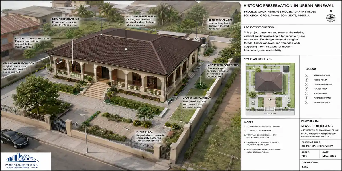
Historic Preservation Model in Oron, Akwa Ibom
Why This Work Is Genuinely Difficult
I won’t sugarcoat it preservation is hard, and not just technically. The materials alone can be a headache; sourcing lime mortar, traditional timber species, or hand-fired bricks that match what was originally used isn’t something your average contractor stocks. Then there’s the funding problem. Preservation work is almost always more expensive than new construction, and in cities where budgets are already stretched thin on basic infrastructure, convincing a government or private owner to spend extra on saving an old building can be a tough sell. Add to that the pressure of land value a heritage building sitting on a prime commercial plot represents, to a developer, a lot of forgone income. This tension between heritage value and market value sits at the center of almost every serious preservation debate you’ll encounter.
Preservation and the People Who Live Around It
Here’s something that doesn’t get talked about enough: preservation isn’t just about the physical structure, it’s about the community wrapped around it. A heritage district that gets frozen in amber for tourists, while the people who actually live there get priced out or forgotten, isn’t really preservation succeeding it’s a different kind of displacement wearing a nicer costume. The better preservation projects treat the surrounding community as part of what’s being protected. That might mean involving local residents in decisions about how a historic market square gets restored, or ensuring that adaptive reuse of an old building serves local needs rather than only external visitors.
Where Nigeria Fits Into This Conversation
Closer to home, heritage protection in Nigeria is still catching up to where it needs to be. We have remarkable sites — the Sungbo’s Eredo earthworks, the Osun-Osogbo Sacred Grove, colonial-era architecture across the South-South and South-West — but enforcement of protective designations is inconsistent, and economic pressure to redevelop prime urban land often wins out over conservation. Strengthening our heritage frameworks, giving local planning authorities real enforcement teeth, and building public appreciation for why these structures matter that’s work still very much in progress.
The Bigger Picture
What I want you to take away from all this is that preservation isn’t the opposite of progress it’s actually a discipline that asks planners to be more thoughtful, not less ambitious. A city that bulldozes every trace of its past ends up feeling like it could be anywhere, and a city that refuses to change at all stagnates. The real skill lies in knowing which buildings anchor a city’s identity and deserve protection, and which deteriorating structures are better served by the renewal approach we covered earlier.
And that balance between saving what matters and transforming what doesn’t work is exactly the space where the next discipline lives. Once you understand renewal and preservation as two separate tools, the natural next question becomes: what happens when a neighborhood needs both at once, woven together into a single coherent strategy? That’s where urban regeneration comes in.
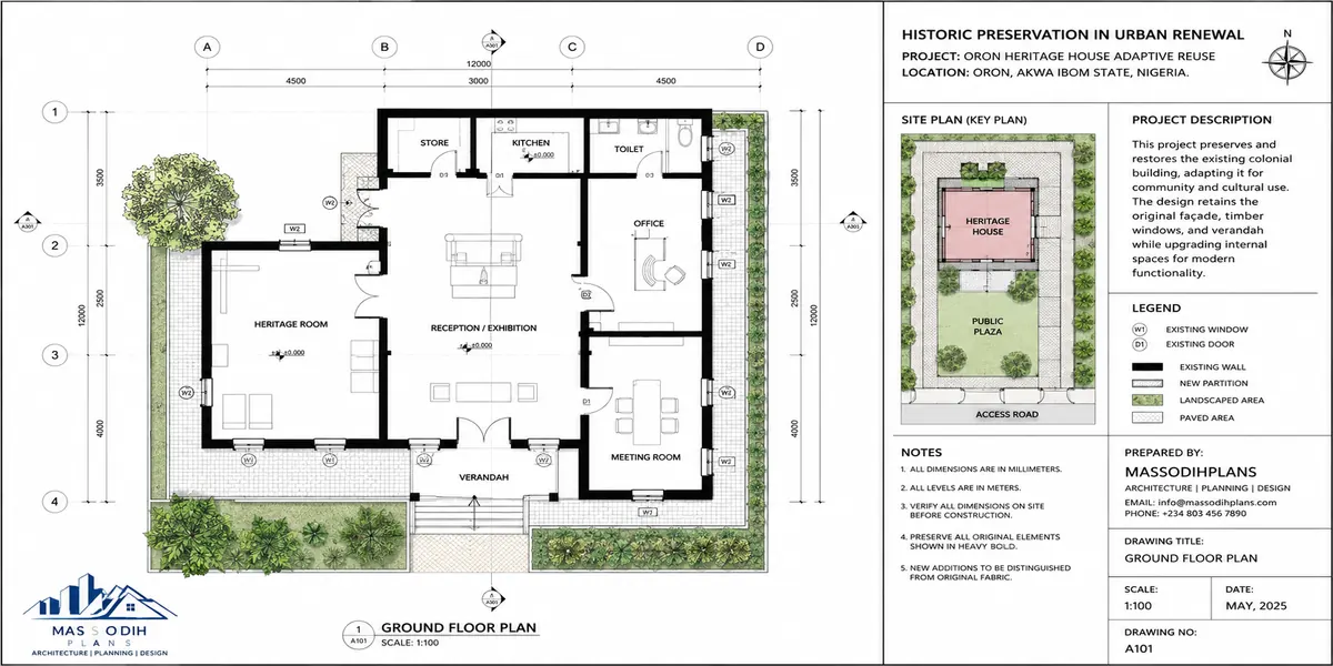
Historic Preservation Urban Renewal
Urban Regeneration
Now here’s where things get interesting, because urban regeneration is often confused with urban renewal, and honestly, even seasoned practitioners blur the line sometimes. Think of it this way: renewal is largely about fixing the physical bones of a place roads, drainage, buildings. Regeneration is broader and more ambitious. It’s about breathing new economic, social, and cultural life into an area that has lost its vitality, not just repairing what’s broken but actively reinventing what a place can become.
What Makes Regeneration Different
A neighborhood can have perfectly sound buildings and still be in decline shops shuttered, young people leaving, investment drying up, a general sense of a place losing its pulse. That’s a regeneration problem, not a renewal problem. You’re not necessarily demolishing anything. You’re asking harder questions: why did this area stop attracting people and money, and what combination of interventions could reverse that trend? Regeneration pulls together economic policy, cultural programming, business incentives, and physical upgrades into one coordinated push, rather than treating infrastructure repair as the whole solution.
The Economic Backbone
Money almost always sits at the center of a regeneration strategy, because a district without economic activity tends to slide right back into decline no matter how nice the new pavement looks. This usually means tax incentives to attract businesses, support for local entrepreneurs, workforce training tied to whatever industries the area is trying to build, and sometimes anchor investments a market, a transit hub, a university satellite campus that give people a reason to come back regularly. In many Nigerian cities, informal markets already play this anchoring role naturally; smart regeneration formalizes and strengthens them rather than displacing them in favor of something imported and unfamiliar.
Bringing the Social Fabric Back
Here’s something planners learned the hard way over the decades: you can pour money into an area and still fail, if you ignore the people already living there. Genuine social regeneration means involving residents in decisions from day one, not presenting them with a finished masterplan and asking for applause. It means preserving community institutions churches, schools, local associations that hold a neighborhood’s social fabric together, while creating new spaces where people naturally gather and interact. A regenerated district that pushes out its original residents hasn’t really regenerated anything; it’s just relocated the decline somewhere else while dressing up the original site for newcomers.
Culture as a Regeneration Tool
This part surprises a lot of my students, but culture is genuinely one of the most powerful and cost-effective regeneration levers available. Arts districts, heritage festivals, public art installations, and adaptive cultural venues draw people into an area for reasons that have nothing to do with shopping or commuting. They create identity a reason for a place to be known as something specific rather than just another forgotten corner of the city. Cities that lean into what already makes a neighborhood distinctive, instead of erasing it in favor of generic development, tend to see regeneration stick far longer than cities that don’t.
Environmental Regeneration
You can’t talk seriously about regenerating a neighborhood in 2026 without addressing its environmental condition polluted waterways, degraded green spaces, poor air quality from unmanaged waste burning, or flood-prone areas with no functioning drainage. Environmental regeneration folds sustainability directly into the broader strategy: restoring green corridors, cleaning up contaminated sites, introducing urban agriculture where land allows, and designing new development with climate resilience baked in from the start rather than bolted on afterward. It’s not a side project; it’s foundational to whether the regeneration lasts.
Measuring If It’s Actually Working
One thing I always stress to students is that regeneration needs honest metrics, not just ribbon-cuttings. Are property values rising in a way that still allows original residents to stay? Is local employment growing? Is foot traffic in commercial areas actually increasing? Are crime rates dropping? These indicators matter more than how polished the final renderings look, because regeneration that only photographs well but doesn’t shift the underlying economic and social conditions isn’t regeneration at all it’s cosmetic renewal wearing a fancier name.
Done well, urban regeneration turns a struggling district into a place people choose to stay in, invest in, and build a future around without pricing out or erasing the very community that gave the place its character in the first place. And that focus on keeping communities rooted in their own neighborhoods is exactly what leads us into the next piece of this puzzle: how individual, often overlooked neighborhoods get revitalized block by block, street by street, from the ground up.
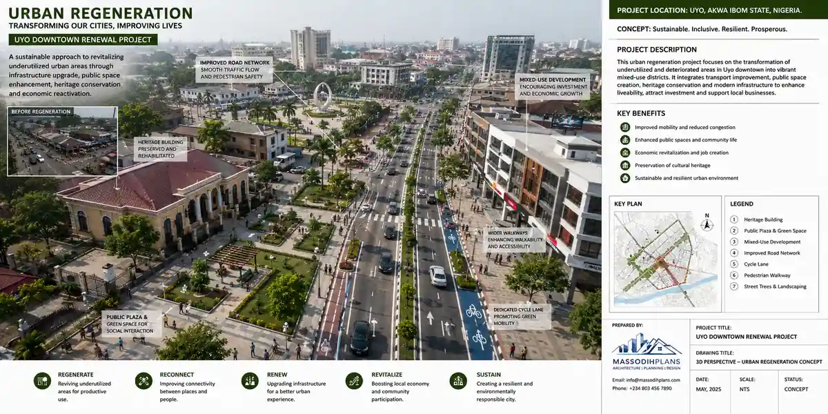
Urban Regeneration Plan
Neighborhood revitalization
Now let’s shift the lens a bit from the citywide, often government-driven scale of regeneration, down to something more intimate: the neighborhood. I remember this distinction being drummed into us back in my master’s program regeneration and revitalization get used interchangeably by a lot of people, but they’re not quite the same animal. Regeneration is often broad, structural, tied to economic strategy across a whole district or city. Revitalization is smaller, more granular, more personal. It’s the difference between rewriting a city’s economic story and simply making one street worth walking down again.
What We Actually Mean by Revitalization
Think of a neighborhood that isn’t dead, just tired. The buildings are standing, people still live there, the shops haven’t all closed but something’s gone flat. Maybe it’s the informal market that used to buzz on Saturdays and now only half-fills. Maybe it’s the housing that’s aged without anyone reinvesting in it. Revitalization is the set of interventions small and large that bring life, activity, and value back into that kind of place without necessarily tearing it down first. It’s less bulldozer, more acupuncture: targeted pressure points that get the whole system moving again.
Reading the Warning Signs
Part of what my geography background at Uyo gave me, long before the planning degree, was an instinct for reading landscapes noticing patterns before you can name them. A declining neighborhood tells you its story if you know what to look for: vacant shopfronts sitting longer than they should, a drop in foot traffic at hours that used to be busy, informal settlement creeping into what used to be planned open space, drainage nobody’s maintained in years. None of these alone means much. Together, they’re a neighborhood asking for help before the decline becomes irreversible.
Community-Led Approaches
Here’s something I try to get into my students’ heads early: the best revitalization rarely starts with an architect’s drawing. It starts with a conversation. Residents know their own streets better than any consultant flying in for a week ever will. A community-led approach means the people who actually live there help decide what gets fixed first maybe it’s the market stalls, maybe it’s a footpath that floods every rainy season, maybe it’s simply better lighting so people feel safe walking home after dark. When revitalization is imposed from above without that input, it tends to look good on paper and feel wrong on the ground.
Top-Down Investment, Done Right
That said, I won’t pretend community energy alone rebuilds broken infrastructure. At some point, government or private capital has to show up repaving roads, restoring utilities, funding small business grants. The trick is sequencing it properly: let community priorities guide where the money goes, rather than parachuting in a generic redevelopment plan and hoping residents adapt to it. I’ve seen both versions play out in different Nigerian cities, and the difference in outcome is stark.
Economic Revitalization vs Social Revitalization
It helps to separate these two threads, even though they’re tangled together in practice. Economic revitalization is about jobs, businesses, foot traffic, property values the measurable stuff. Social revitalization is softer but just as vital: rebuilding trust, restoring a sense of ownership and pride, giving people reasons to gather again. A neighborhood can get economically “revitalized” new shops, rising rents while its original community quietly gets priced out and scattered. That’s not success. That’s displacement wearing a nicer coat.
Avoiding the Gentrification Trap
Which brings me to the part I always slow down for when teaching this. Revitalization done carelessly becomes gentrification and gentrification isn’t automatically progress just because property values go up. If the people who endured the decline are the same people who get pushed out once the neighborhood improves, something in the process has failed, even if the street looks beautiful afterward. Good revitalization plans build in protections from the start: rent stabilization measures, support for existing small businesses, housing options that don’t force long-term residents out the moment the area becomes desirable again.
Get all of this right, and revitalization becomes the bridge between a neighborhood’s past and its next chapter without erasing the people who made it worth saving in the first place. And that idea of preserving what’s worth keeping while still moving forward leads naturally into a discipline that takes that principle even further: finding new life for old buildings instead of replacing them. That’s adaptive reuse, and it’s where we’re headed next.
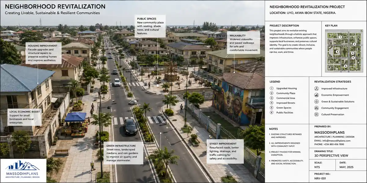
Urban Neighborhood Revitilization: Urban Planning & Urban Design
Adaptive Reuse
Here’s something I always tell my students when we get to this part of the syllabus: not every old building deserves a wrecking ball, and not every empty warehouse is actually “dead” it’s just waiting for someone with imagination to see it differently. That’s the whole spirit of adaptive reuse. Instead of tearing a structure down because its original function has expired, you repurpose it for something new while keeping its bones, its character, and often its soul intact.
I remember during my master’s, one of our field trips took us through a cluster of old colonial-era warehouses that had long since stopped serving their original trade purpose. Some had been converted into offices, one into a small event hall. What struck me wasn’t the architecture itself it was how much cheaper and faster it was to convert those spaces compared to what it would’ve cost to demolish and rebuild from scratch. That lesson stuck with me more than anything I read in a textbook.
What Makes a Building a Good Candidate
Not every structure is a good fit for reuse. The ones that work best usually have solid structural bones sound foundations, decent floor-to-ceiling heights, and a layout flexible enough to accommodate a different function without a complete gut job. Old factories, warehouses, churches, schools, and even colonial administrative buildings tend to make excellent candidates because they were originally built with generous proportions and durable materials. A building that’s structurally compromised, on the other hand, or one so specifically designed for a single function that it resists any reconfiguration, usually isn’t worth the effort.
Common Conversion Patterns
You’ll see certain patterns repeat themselves across cities. Industrial warehouses often become loft apartments, art studios, or co-working spaces their open floor plans and tall ceilings lend themselves naturally to that kind of flexibility. Old schools and hospitals frequently transform into community centers or mixed-income housing. Religious buildings, when they’ve fallen out of active use, sometimes become cultural venues, libraries, or even boutique hotels. Closer to home, I’ve seen former government quarters and old civil service buildings in parts of Akwa Ibom repurposed into private offices and training centers proof that this isn’t just a Western phenomenon reserved for European cathedrals turned nightclubs.
Why It Actually Makes Economic Sense
This is the part I really try to hammer home to students: adaptive reuse is rarely just a sentimental choice, it’s often the financially smarter one. Demolition is expensive, disposal of construction waste is expensive, and rebuilding from ground zero means starting your utility connections, foundation work, and structural framing all over again. When you reuse an existing shell, you skip a huge chunk of that cost and timeline. Add in the fact that many jurisdictions now offer tax incentives or expedited approvals for adaptive reuse projects especially ones involving heritage-adjacent structures and the business case writes itself for a lot of developers.
The Environmental Angle
There’s also a sustainability argument that doesn’t get talked about enough. Every building already standing represents embodied carbon the energy that went into producing its materials and constructing it in the first place. Demolishing that structure wastes all of that embedded energy and adds construction debris to landfills. Reuse keeps that embodied value working for you instead of throwing it away.
Where It Gets Tricky
I won’t pretend it’s always straightforward. Retrofitting old buildings to meet modern electrical, plumbing, and accessibility codes can be technically demanding, especially when the original structure wasn’t designed with those systems in mind. Sometimes what looks like a good candidate on the surface turns out to have hidden structural issues once you actually get into the walls and foundations which is why a proper condition assessment, the same kind we discussed under urban renewal, is non-negotiable before anyone commits to a reuse project.
Adaptive reuse, done well, sits right at the intersection of practicality and respect for what a building already represents. And that respect for what already exists for the history embedded in a structure is really the same instinct that drives our next conversation: heritage conservation, and why some buildings deserve protection not because they’re useful, but because of what they mean.
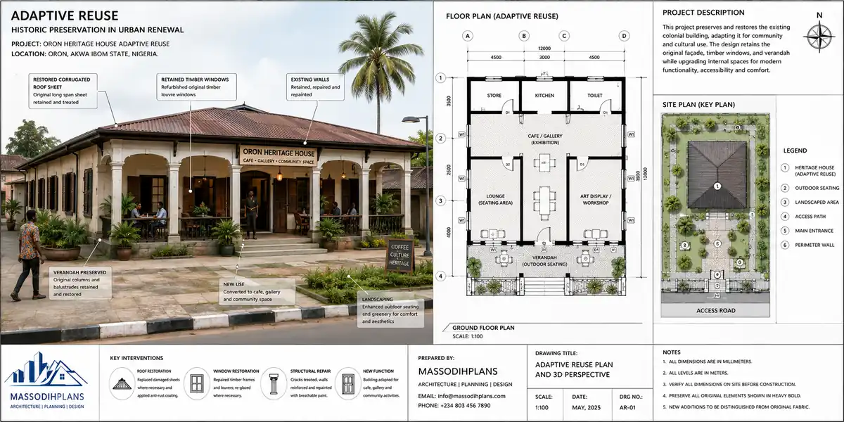
Adaptive Reuse in Urban Renewal Plan
Heritage Conservation
I remember sitting in a planning theory class during my master’s programme at the University of Uyo, listening to a lecturer make a point that stuck with me ever since: a city without its old buildings is a city without a memory. Heritage conservation is really about protecting that memory the physical evidence of how people lived, worshipped, traded, and built community before us. It’s the deliberate work of identifying places with historical, cultural, architectural, or spiritual significance and putting systems in place to protect them from decay, demolition, or careless alteration.
What Counts as Heritage
Heritage isn’t limited to grand monuments. Yes, it includes palaces, colonial-era buildings, and national landmarks, but it also covers the quieter things a traditional compound layout, an old market structure, a shrine, a century-old church, or even a street pattern that reflects how a community historically organized itself. During my geography degree, we studied how settlement patterns across Akwa Ibom and the wider Niger Delta carried embedded histories: the placement of a village square, the orientation of compounds toward a river or a shrine. Those spatial arrangements are heritage too, even when no single building stands out as spectacular.
Tangible and Intangible Heritage
Conservation professionals usually split heritage into two categories, and this distinction matters practically. Tangible heritage covers the physical stuff buildings, monuments, archaeological sites, artifacts. Intangible heritage covers practices, festivals, oral traditions, craftsmanship, and languages tied to a place. A well-rounded conservation strategy protects both. You can restore a building perfectly, but if the festival or ritual practice that gave that building its meaning has died out, you’ve preserved a shell without its soul. This is something planners in culturally rich regions like ours need to take seriously protecting the physical structure alongside the living traditions connected to it.
Legal and Policy Protection
Nothing gets conserved reliably without a legal backbone. This usually means heritage listing or designation an official process where a government body assesses a site and grants it protected status, which then restricts what owners or developers can legally do to it. In Nigeria, this responsibility largely sits with the National Commission for Museums and Monuments, alongside state-level planning authorities. The challenge, honestly, is enforcement. A site can be listed on paper and still fall into ruin if there’s no funding, no monitoring, and no political will behind the designation. Strong conservation policy needs teeth, not just intention.
Adaptive Reuse as a Conservation Tool
One of the smartest ways to conserve a heritage building is to keep it useful. An old colonial building converted into a museum, a heritage warehouse turned into a cultural center, a historic residence repurposed as a boutique guesthouse these interventions keep the structure standing because someone has a reason to maintain it. A building with no function tends to be neglected regardless of how much historical value it holds on paper. I always tell people the surest way to lose a heritage building isn’t demolition it’s abandonment.
Community Involvement
Conservation efforts that ignore the people living around the heritage site tend to fail. Local communities often hold knowledge about a site’s history that no archive contains, and their buy-in determines whether protection actually sticks long-term. Where communities feel ownership over a heritage site, they defend it. Where they feel disconnected from the process, that same site becomes vulnerable to encroachment, vandalism, or quiet demolition once nobody is watching closely.
Balancing Development Pressure
The hardest part of heritage conservation, in my experience observing planning practice across Akwa Ibom and Rivers States, is the constant tension with development pressure. Land in historic districts is often prime real estate, and the temptation to demolish and rebuild for commercial gain is real. Good planning frameworks try to resolve this through conservation overlays zoning tools that permit development around a heritage site while restricting alteration to the protected structure itself.
Heritage conservation, at its heart, asks a city to slow down and think generationally rather than just commercially. Once that thinking takes root at the neighborhood scale, it naturally opens into a bigger conversation how entire districts, not just individual buildings, get reimagined and rebuilt for the future. That’s where city redevelopment comes in.
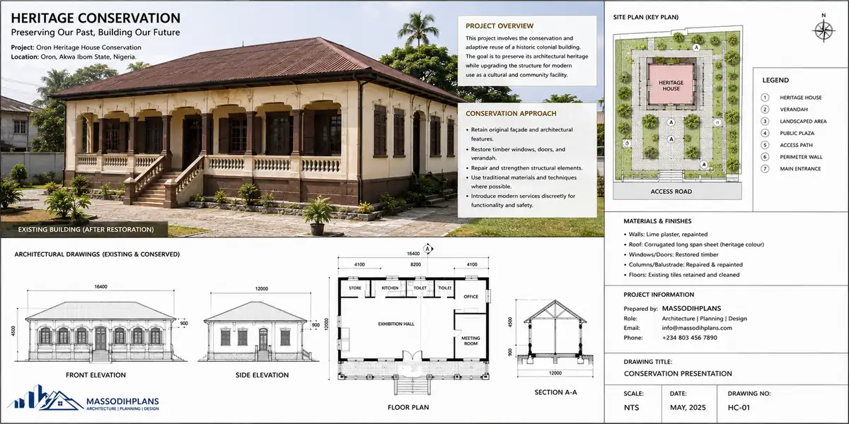
Heritage Conservation
City Redevelopment
I still remember sitting in a planning theory class at the University of Uyo, years into my master’s programme, when a lecturer put up a slide of Port Harcourt’s old GRA layout next to a satellite image of the same area today. The contrast stunned half the class. That single image did more to teach me what redevelopment actually means than any textbook chapter could. So let’s break this one down the way I wish someone had broken it down for me back then.
City redevelopment is the large-scale transformation of an urban area’s built environment, function, and economic role, usually driven by the recognition that the existing land use no longer serves the city’s needs. It’s a broader, more ambitious cousin of urban renewal. Where renewal often focuses on rehabilitating what already exists, redevelopment frequently starts closer to a blank slate clearing outdated industrial zones, converting underused waterfronts, or repurposing entire districts that have outgrown their original purpose. Think of old dockyards turned into mixed-use business hubs, or a former railway corridor reborn as a commercial spine. That’s redevelopment at work.
Why Cities Redevelop
During my geography years, before I ever touched planning theory, I learned that land use is never static — it responds to economic pressure, population shifts, and changing technology. A district built for 1970s manufacturing doesn’t automatically make sense in a service-driven 2026 economy. Cities redevelop for a handful of recurring reasons: economic obsolescence, where an area’s original function no longer generates value; infrastructure failure, where roads, drainage, and utilities have degraded beyond cost-effective repair; population pressure, where growing cities need to intensify land use in already-built areas rather than sprawl endlessly outward; and strategic repositioning, where a city wants to reinvent a district’s identity entirely turning a neglected industrial belt into a technology corridor, for instance.
Types of Redevelopment Strategies
Not all redevelopment looks the same, and this is where the subsections matter. The first type is comprehensive redevelopment, which involves demolishing most or all existing structures and rebuilding from scratch. This tends to happen in areas where the building stock is structurally unsound or where the existing layout fundamentally conflicts with modern planning standards narrow streets that can’t accommodate emergency vehicles, for example, or plot arrangements that make proper drainage impossible.
The second type is selective or partial redevelopment, where planners retain viable structures and infrastructure while replacing only what’s failing. This approach costs less, disrupts fewer communities, and tends to preserve more of a district’s original character something I always try to emphasize when clients ask me why we’re not just clearing a site entirely.
The third type, and one I find genuinely exciting, is catalytic redevelopment. This is when a single high-impact project a stadium, a transit hub, a flagship commercial development is used to trigger a ripple effect of private investment across an entire district. You build one thing well, and the market does the rest of the redevelopment work around it over the following decade.
The Planning Process Behind It
Redevelopment doesn’t happen by accident, and it certainly doesn’t happen overnight. It typically follows a sequence that starts with a feasibility and market analysis understanding whether there’s actual economic demand for the proposed new use of the land. From there comes a masterplan, which sets out the zoning, density, infrastructure requirements, and phasing of the project. Then comes land assembly, often the most politically delicate stage, since it usually involves negotiating with multiple landowners, compensating existing occupants, and sometimes navigating disputes over customary land rights a challenge that’s particularly familiar to those of us working across Akwa Ibom and Rivers States, where land tenure arrangements can complicate even well-intentioned projects.
The Human Side of Redevelopment
Here’s something I try to drill into younger planners I mentor: redevelopment is never purely a technical or economic exercise. It reshapes who belongs in a place. A district redeveloped without care for its existing residents can end up displacing the very people it should have been built to serve. This is the same conversation we have when discussing renewal, but it hits differently at the scale of redevelopment, because entire livelihoods markets, informal trade networks, generational businesses can be wiped out by a single masterplan decision. The best redevelopment projects I’ve studied and worked around always build in relocation support, phased timelines that don’t strand people mid-transition, and genuine consultation rather than a box-ticking public notice buried in a newspaper nobody reads.
Financing Large-Scale Redevelopment
Money is always the elephant in the room. Comprehensive redevelopment demands capital far beyond what most municipal budgets can absorb alone, which is why public-private partnerships dominate this space globally. Government typically provides the land, the zoning approvals, and sometimes the primary infrastructure, while private developers fund the buildings themselves in exchange for long-term returns. Done well, this model delivers transformed districts without bankrupting city coffers. Done poorly, it produces developments that prioritize investor returns over public benefit a pattern that has played out in cities on every continent, and one worth watching closely as Nigerian cities pursue increasingly ambitious redevelopment schemes.
Measuring Whether It Worked
A redeveloped district’s success isn’t measured only by how modern it looks in photographs. The real test comes years later: Did the area retain economic diversity, or did it become exclusively upscale? Did infrastructure investment hold up under actual usage, or did drainage and roads fail again within a decade? Did the community that surrounded the project benefit from proximity, or were they pushed further to the margins?
Redevelopment, at its best, gives a city a genuine second chance at getting a district right. But that second chance only means something if it’s built on infrastructure and systems designed to last which is exactly why the next conversation naturally turns toward sustainability, and how cities are learning to redevelop not just for today’s needs, but for the decades of environmental and demographic pressure still ahead.
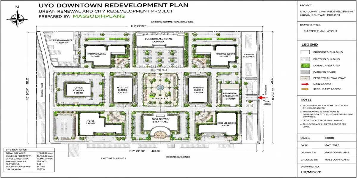
Urban Renewal Redevelopment Plan
Sustainable Urban Development
Here’s something I still remember from my master’s classes at the University of Uyo one of my lecturers used to say that a city can be beautiful, efficient, and completely unsustainable at the same time. That idea stuck with me long after I left the lecture hall, because it’s the kind of thing you don’t fully appreciate until you’re out in the field, watching a neighborhood grow faster than the environment around it can absorb. Sustainable urban development is really the planning world’s answer to that tension: how do we build cities that work today without quietly setting up failure for the generation that comes after us?
Balancing Growth with Environmental Limits
Back in my first degree, studying geography, I spent a lot of time on land-use patterns and how human settlement interacts with natural systems drainage basins, vegetation cover, soil behavior. That foundation shaped how I think about sustainability now. It isn’t just about adding solar panels or planting trees along a road; it’s about designing growth so it doesn’t outrun what the land and water systems around it can handle. A neighborhood built without regard for its natural drainage corridor, for instance, isn’t sustainable no matter how green its buildings look the first heavy rainy season will prove that.
Energy-Efficient and Resource-Conscious Design
At the building and infrastructure level, sustainability shows up in choices most residents never notice: orientation that reduces heat gain, materials that don’t demand constant energy-intensive cooling, water systems designed for reuse rather than waste. In much of Nigeria, where power supply is inconsistent, this isn’t an abstract ideal it’s practical necessity. A development that factors in passive cooling and rainwater harvesting from the start isn’t chasing a trend; it’s simply built to function better in the environment it sits in.
Mixed-Use and Compact Development
One thing planning school really drilled into me was the cost of sprawl not just the environmental cost, but the sheer inefficiency of it. When a city spreads outward without density, every new road, pipeline, and power line has to stretch further to serve fewer people per kilometer. Sustainable development leans the other way: mixing housing, commerce, and services close together so people can walk to what they need instead of driving everywhere. It sounds simple, but it changes everything about how a district actually lives day to day.
Social and Economic Sustainability
This part often gets left out of the conversation, and it shouldn’t be. A development that pushes out the very people who built a community’s character in the name of “green” design has failed at sustainability just as surely as one that pollutes a river. Genuine sustainable planning protects affordability, keeps local economies intact, and makes sure the benefits of new infrastructure don’t just flow to whoever can afford the newest units. I saw this tension play out repeatedly in fieldwork across Akwa Ibom and Rivers States good intentions on paper, but communities left out of the process in practice.
Resilience and Climate Adaptation
Given how much flooding and erosion already affect the South-South region, resilience isn’t optional here it’s foundational. Sustainable development has to plan for the climate conditions a location will face in twenty or thirty years, not just the ones it faces today. That means elevated foundations in flood-prone zones, proper stormwater infrastructure, and land-use decisions that respect natural floodplains instead of building straight through them.
Put all of that together, and sustainable urban development really becomes a discipline of restraint as much as ambition knowing when to build up rather than out, when to preserve a wetland rather than fill it, and when to prioritize the people already living somewhere over the next wave of investment. It’s a philosophy that has to run through every other layer of planning we’ve covered so far, and it becomes especially visible once you step outside the buildings themselves and into the shared spaces between them the streets, parks, and squares where a city’s daily life actually happens. That’s exactly where we’re headed next.
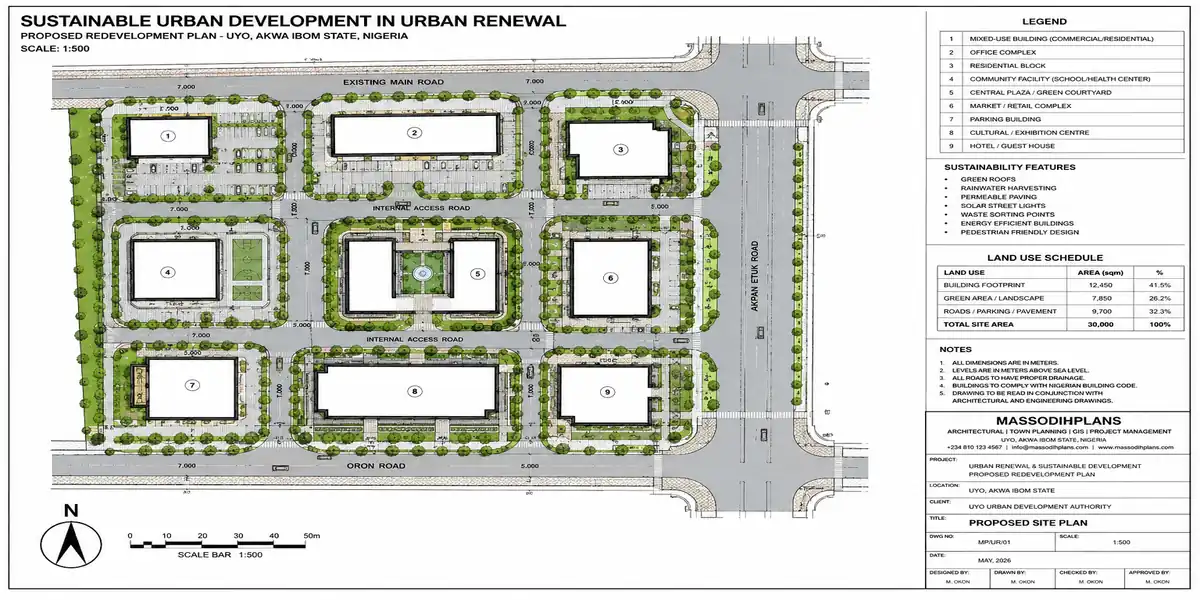
Sustainable Urban Development
Public-Space Improvement
I remember sitting in one of my urban design classes at Uyo, years after I’d already finished my geography degree, and my lecturer said something that stuck with me: “A city without good public space is just a collection of private interests standing next to each other.” At the time it sounded a bit dramatic. Now, after fifteen years of walking through neighborhoods across Akwa Ibom and Rivers States, I understand exactly what he meant. Public space is where a city actually becomes a community parks, plazas, sidewalks, markets, waterfronts, even the shaded areas under a bridge where traders set up shop. When these spaces are neglected, something in the social life of a place quietly breaks down.
Why public space gets overlooked
Here’s a pattern I’ve seen repeat itself in project after project: when budgets get tight, public space is almost always the first thing cut. Roads and drainage get prioritized because they’re visible and measurable, while a poorly maintained park or an unlit walkway gets pushed down the list. I understood this dynamic more clearly during my master’s fieldwork, when I kept noticing that the neighborhoods with the weakest public spaces were also the ones with the least social cohesion fewer informal gatherings, less foot traffic, more distrust between neighbors. Public space isn’t decoration. It’s infrastructure for community life, and treating it as optional tends to cost a city more in the long run than it saves upfront.
Reclaiming underused and derelict spaces
A good starting point for any public-space improvement effort is identifying land that’s already there but going to waste — an abandoned lot, an unused roundabout, a stretch of riverbank nobody has touched in years. These spaces don’t need massive budgets to transform; sometimes clearing debris, adding seating, planting shade trees, and improving lighting is enough to bring people back. I’ve seen this happen with small neutral spaces in Uyo that went from empty and slightly unsafe to genuinely used within a few months of light intervention. The lesson from my geography training applies here too: understand the existing land use patterns first, because you’re rarely starting from a blank slate.
Designing for everyday use, not just special occasions
A mistake I see often is designing public spaces that only work for events a grand plaza that looks impressive in renderings but sits empty on an ordinary Tuesday afternoon. Good public space design accounts for daily life: shaded benches for elderly residents, safe play areas for children, walkable paths connecting to transit stops or markets, and enough activity nearby (small kiosks, food vendors) to keep the space naturally occupied throughout the day. Spaces that feel alive at 10am on a random weekday are usually the ones planners got right.
Accessibility and inclusive design
No public-space improvement plan is complete without asking who can actually use the space. Ramps for wheelchair access, clear paths for the visually impaired, seating at different heights, and safe crossings for children are not add-ons they’re the difference between a space that serves everyone and one that quietly excludes a portion of the community. I try to build this into every layout I review, because inclusive design isn’t a luxury feature; it’s the baseline for public infrastructure that’s meant to serve the public.
Safety, lighting, and maintenance
A beautifully designed space that’s poorly lit at night or badly maintained after the first year will lose its users fast. Consistent lighting, visible sightlines (avoiding dense blind corners), and a realistic long-term maintenance plan matter just as much as the initial design. Too many projects pour resources into construction and forget that upkeep is what determines whether a space stays valuable five years down the line.
Greenery and climate comfort
Trees, shaded walkways, and permeable surfaces do more than look pleasant they cool down spaces significantly in our climate, reduce flooding through better drainage, and encourage people to linger rather than rush through. Any public-space plan in our region that ignores climate comfort is missing one of the most practical tools available for keeping a space usable year-round.
Public space, done right, becomes the connective tissue of a neighborhood and that connective role naturally leads into how we think about moving people between these spaces, which brings us to transportation planning.
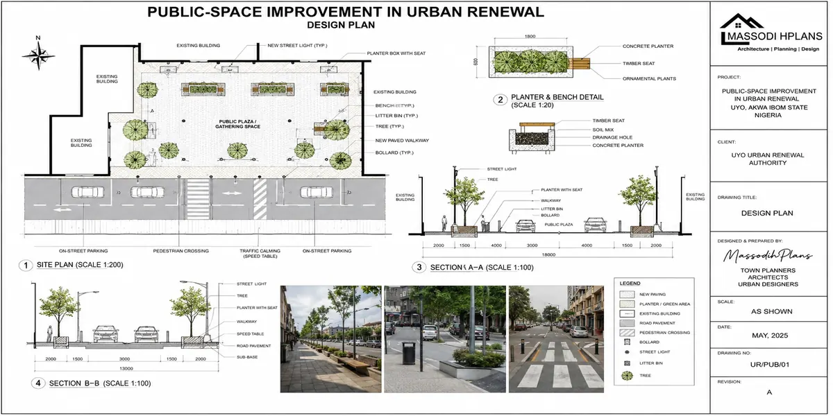
Public Space Improvement Urban Renewal
Transportation Planning
I still remember sitting in a transportation planning seminar during my master’s at the University of Uyo, staring at a traffic flow diagram and realizing something that changed how I see cities forever: a road network is basically the circulatory system of a city. Block an artery, and everything downstream starts to suffer. That idea has stuck with me through fifteen years of fieldwork, and it’s the lens I want to hand to you here.
Transportation planning is the discipline of designing how people and goods move through a city the roads, rail lines, footpaths, bus corridors, and cycling infrastructure that either make a city livable or slowly choke it. Back in my geography undergraduate days, we studied movement patterns almost like natural phenomena, watching how population density and economic activity pulled traffic toward certain corridors the way gravity pulls water downhill. That grounding turned out to be more useful than I expected, because transportation planning really is about reading those pulls correctly before you pour a single slab of concrete.
Road Network Design
This is the backbone. A functional road hierarchy separates fast-moving arterial roads from slower local streets, so that through-traffic doesn’t strangle residential neighborhoods and neighborhood traffic doesn’t bottleneck citywide movement. Nigerian cities often struggle here because growth happened faster than the road hierarchy could keep up, leaving arterial-level traffic squeezed through streets that were only ever meant to serve a handful of houses. Good road design plans for that hierarchy from the outset arterials, collectors, and local streets each doing their own job.
Public Transit Integration
Roads alone can’t carry a growing city. At some point, you simply run out of room to widen a street, and that’s where transit buses, BRT corridors, light rail has to step in. The cities that get this right treat transit as infrastructure worth investing in early, not as an afterthought bolted on once congestion becomes unbearable. Lagos’s BRT system is a decent local reference point: imperfect, but proof that dedicated transit corridors can meaningfully shift how people move once the alternative becomes genuinely competitive with driving.
Pedestrian and Cycling Infrastructure
Here’s something my professors drilled into us that I still repeat to younger planners: a street that’s hostile to walking is a street that’s failing half its users. Sidewalks, safe crossings, and cycling lanes aren’t decorative extras they’re the connective tissue that gets people from their front door to the bus stop or the market without risking their lives on the shoulder of a highway. Too many of our developing streets skip this entirely, and it shows in how few people feel safe walking even short distances.
Traffic Management Systems
Signals, intersection design, one-way systems, roundabouts this is the layer that keeps the whole network from seizing up under its own volume. It’s less glamorous than a new highway, but well-designed traffic management can unlock capacity that already exists in a road network without spending a naira on new construction. I’ve seen intersections transformed just by rethinking signal timing and lane markings.
Parking Policy
Parking is one of those things nobody thinks about until it’s a nightmare. How much parking a development requires, where it’s located, and how it’s priced all shape travel behavior more than people realize. Generous free parking quietly encourages more driving; scarcer, priced parking nudges people toward transit or shared mobility. It’s a policy lever that’s easy to overlook and surprisingly powerful.
Multimodal Connectivity
The real goal isn’t perfecting any single mode it’s making sure they all talk to each other. A commuter should be able to walk to a bus stop, take a bus to a rail station, and cycle the last stretch home without the system fighting them at every transfer point. That seamlessness is what separates a transportation network from a mere collection of roads.
What ties all of this together is land use because how a city moves is inseparable from how a city is arranged. Where you put housing, jobs, and services determines how far people need to travel and by what means, which is exactly the territory land-use planning covers next.
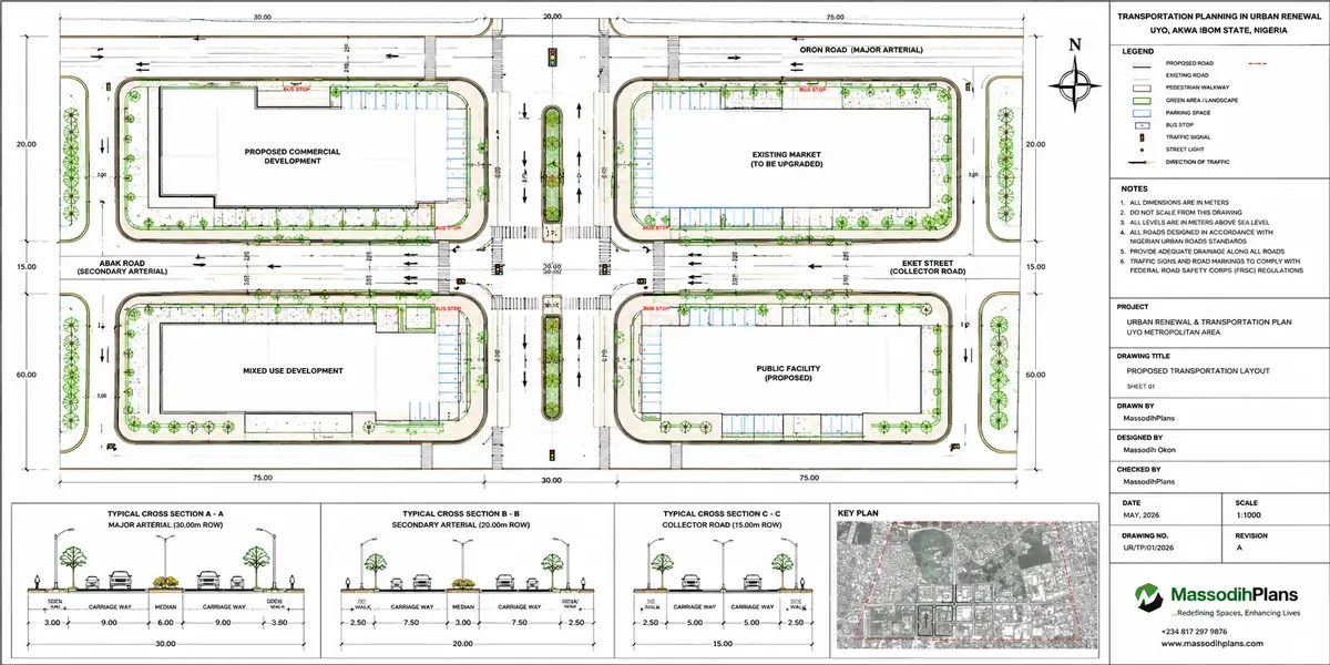
Transportation Planning
Land-Use Planning
Here’s something I tell my students every time this topic comes up: land-use planning is the closest thing our profession has to a foundation stone. Everything else we’ve covered in this guide renewal, preservation, revitalization, adaptive reuse sits on top of decisions about which piece of land gets used for what. Get land-use planning wrong, and no amount of clever redevelopment fixes it later. Get it right, and half the problems cities struggle with simply never show up in the first place.
I remember this clicking for me properly during my master’s in urban and regional planning at the University of Uyo, after coming from a geography background in my first degree. Geography teaches you to read land soil, drainage, slope, proximity to water. Planning teaches you to decide what to do with what you’ve read. Land-use planning is that marriage of the two: understanding a piece of land on its own terms, then deciding, deliberately, what belongs there.
What Land-Use Planning Actually Involves
At its simplest, it’s the process of allocating land within a city or region to specific functions residential, commercial, industrial, agricultural, institutional, recreational based on suitability, demand, and long-term development goals. But “allocating” undersells how much judgment goes into it. A planner has to weigh soil quality and flood risk against population growth projections, weigh a community’s cultural attachment to a piece of land against a developer’s proposal for it, and weigh today’s needs against what the city will need in thirty years. It’s part science, part negotiation, part educated guesswork about the future.
Zoning: The Tool Everyone’s Heard Of
Zoning is where land-use planning becomes visible to ordinary people. It’s the regulatory instrument that translates a land-use plan into enforceable rules this parcel is residential, that one’s commercial, this strip along the river stays undeveloped. Zoning gives structure to a city, but it can also calcify bad decisions if it isn’t revisited. I’ve seen zoning maps in Nigerian cities that were drawn decades ago and never meaningfully updated, even as the actual use of the land shifted entirely underneath them. A good zoning framework is a living document, not a relic.
Reading the Land Before You Plan It
This is the part closest to my geography roots. Before any allocation decision gets made, a planner needs a proper land suitability assessment topography, soil stability, groundwater levels, flood exposure, existing vegetation. Skip this step, and you end up with residential estates built on floodplains, or commercial zones sited where drainage was never going to work. A surprising number of land-use conflicts in rapidly growing Nigerian cities trace back to this exact failure: someone allocated land for a use it was never physically suited to.
Balancing Competing Demands
No city has unlimited land, which means land-use planning is constantly arbitrating between competing claims. Agricultural land at the urban fringe wants to become housing. Industrial zones want to expand into what used to be buffer green space. Residents want density kept low; investors want density pushed high. Part of what I try to get across to students is that there’s rarely a “correct” answer here there’s a defensible one, backed by data, community input, and a clear-eyed view of trade-offs.
Land-Use Planning as the Bridge to Transportation
One thing that took me a while to fully appreciate is how tightly land-use and transportation are wound together. Where you put housing determines how people move. Where you put jobs determines commuting patterns. A land-use plan that ignores transportation ends up producing sprawl, congestion, and neighborhoods that are functionally cut off from the rest of the city regardless of how sensible the zoning looked on paper. That interdependence is exactly why transportation planning can’t really be treated as a separate conversation; it’s the natural next layer once the land-use foundation is in place, and it’s where we’re headed next.
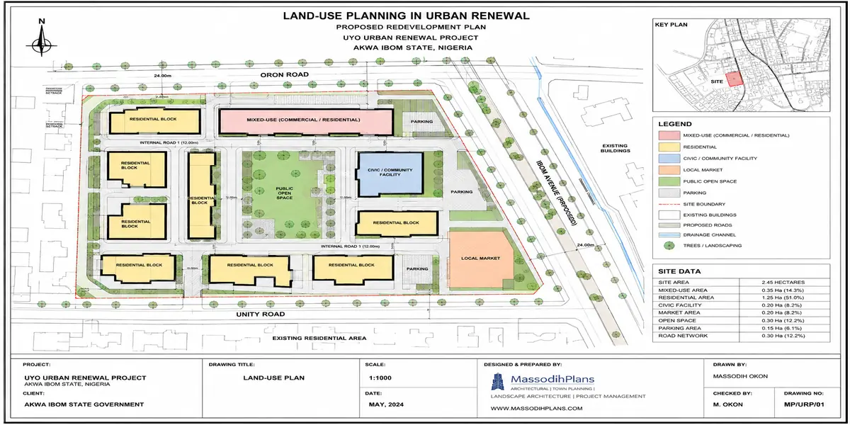
Land Use Planning Urban Renewal
Summary and Conclusion
Urban planning and urban design shape far more than the appearance of a city. They determine how people move, where homes and businesses grow, how public spaces function, how infrastructure is provided, and how communities respond to population growth and changing economic needs. A successful modern city does not happen by accident; it emerges from coordinated decisions about land use, transportation, housing, environmental protection, public facilities, urban form, and development control.
Throughout this guide, we have explored how urban planning provides the strategic framework for managing growth, while urban design translates those strategies into functional, attractive, safe, and people-centred places. We have also examined development planning, zoning, infrastructure, mobility, public spaces, sustainability, regeneration, and urban renewal. Together, these elements provide a practical foundation for understanding how existing settlements can be improved and how new urban areas can be planned more intelligently.
From site analysis to implementation, every planning decision can influence urban quality for generations. The most important lesson is that good urban development must balance physical growth with human needs. A city may have impressive buildings and wide roads, yet still perform poorly when housing is unaffordable, public spaces are neglected, traffic is unmanaged, drainage is inadequate, or development ignores environmental conditions. Effective planning therefore requires evidence, professional judgement, community participation, technical analysis, and long-term thinking.
Whether you are a student, planner, architect, developer, policymaker, researcher, or property owner, understanding these principles can help you make better decisions about land and development.
Call to Action
Ready to apply these ideas to a real project? Explore more practical planning, architectural, landscape, GIS, and development resources from MassodihPlans, or contact us for professional guidance on transforming your land-development idea into a practical, well-planned solution.