Survey Plan vs Deed of Assignment in Nigeria
A survey plan and a deed of assignment are not the same document, and mixing them up is one of the fastest ways to lose money on Nigerian land. In simple terms: a survey plan tells you exactly where your land is, its size, its boundaries, and its coordinates on the ground. A deed of assignment tells you who legally owns that land and transfers that ownership from a seller to a buyer. One is about location and measurement. The other is about legal title and transfer of rights. You need both, and neither one can substitute for the other a fact I have watched trip up buyers again and again in my years working on land matters across Akwa Ibom and Rivers States.
Quick Answer: A survey plan is a technical/geographic document prepared by a licensed surveyor showing your land’s boundaries, size, and coordinates. A deed of assignment is a legal document showing that ownership has been transferred to you. Buying land with only one of these is buying half a story.
If you are trying to buy land in Nigeria, verify a property before payment, or simply understand the paperwork a seller has handed you, this article walks through both documents in plain language — what they are, what they can and cannot prove, and the specific mistakes that cost buyers their savings.
What Is a Survey Plan?
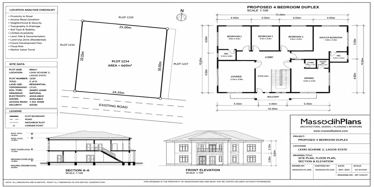
A survey plan is a technical drawing prepared by a licensed surveyor after a physical inspection of a piece of land. It shows the land’s exact boundaries, dimensions, bearings, coordinates, and beacon positions, and it carries a unique survey number that is registered with the state’s Surveyor-General’s office.
During my internship, I observed that many people treat the survey plan as “the ownership document.” It isn’t. A survey plan answers the question: where exactly is this land, and how big is it? It does not, on its own, answer the question: who owns it?
Key Components of a Survey Plan
- Survey number: a unique reference registered at the Surveyor-General’s office
- Coordinates: precise GPS/geographic positioning of each boundary point
- Bearings and distances: the direction and length of each boundary line
- Beacon information: physical markers placed on the ground at each corner
- Parcel identification: the plot number and layout it belongs to, where applicable
- Scale and area: the total size of the land, usually in square metres or hectares
What Is a Deed of Assignment?
A deed of assignment is a legal document that transfers ownership rights in land from a seller (the assignor) to a buyer (the assignee). It records the identities of both parties, describes the property (often referencing the survey plan), states the purchase consideration, and is signed, witnessed, and critically should be registered and stamped.
Based on projects I have worked on, I have seen deeds of assignment that were beautifully drafted but referenced a survey plan that didn’t match the land actually being sold, or that described a boundary that overlapped with a neighbour’s plot. The deed can only be as reliable as the survey information it depends on.
Survey Plan vs Deed of Assignment: Side-by-Side Comparison
| Feature | Survey Plan | Deed of Assignment |
|---|---|---|
| Prepared by | Licensed surveyor | Lawyer/legal practitioner |
| Main purpose | Shows boundaries, size, location | Transfers legal ownership |
| Proves ownership? | No, on its own | Yes, when properly executed and registered |
| Registered with | Surveyor-General’s office | State Land Registry |
| Shows government acquisition status? | Often, if updated | Rarely explicitly |
| Needed for building approval? | Yes, mandatory | Yes, as part of title evidence |
| Can exist without the other? | Yes, but incomplete for a transaction | Yes, but risky without a verified survey |
Why You Need Both Documents Together
In my experience, the safest land transactions are the ones where the survey plan and the deed of assignment tell the same, consistent story. The deed should reference the exact survey plan number, and that survey plan should match what a fresh site inspection reveals on the ground. When these three things deed, survey plan, and physical site agree, you’re in reasonably safe territory. When any one of them contradicts the others, that’s your warning sign.
Land Ownership Verification: What Survey Plans Can and Cannot Prove
While working on site plans, I noticed that many families in the South-South region rely heavily on old survey plans passed down for decades, without checking whether the land has since been affected by government acquisition, excision, or a gazette notice. A survey plan tells you the geography; it does not automatically tell you the current legal status of that geography.
What a Survey Plan Can Confirm
- The exact size and shape of the land
- Where the boundaries and beacons are physically located
- Whether the plot matches what a seller is showing you on the ground
What a Survey Plan Cannot Confirm on Its Own
- Whether the seller genuinely owns the land
- Whether the land has been sold to more than one person
- Whether the land falls under government acquisition
- Whether there is a pending court case over the land
This is why proper verification always involves visiting the relevant Ministry of Lands and the Surveyor-General’s office, not just collecting documents from the seller.
Boundary Issues: Where Most Nigerian Land Disputes Begin
I have seen this mistake repeatedly: buyers accept a seller’s word about where the boundary lines fall, without insisting on a proper re-survey or beacon confirmation. Boundary disputes are, in my field experience, the single most common land conflict in family and community land across Akwa Ibom and Rivers States.
Common Boundary Problems
- Missing or shifted beacons: beacons removed, buried, or moved over time
- Encroachment: a neighbouring structure built beyond its actual boundary
- Family land conflicts: multiple family members selling overlapping portions
- Conflicting survey plans: two plans registered over the same coordinates due to poor records
During field inspections, I discovered that a simple beacon confirmation exercise before purchase where a licensed surveyor physically locates and verifies each beacon against the survey plan resolves the majority of boundary uncertainty before money changes hands.
Government Acquisition: The Hidden Risk Survey Plans Sometimes Reveal
One lesson I learned early is that a beautiful, well-drawn survey plan means very little if the land sits inside a government acquisition area. Government acquisition, committed acquisition, and global acquisition all restrict or nullify private transactions, even where a survey plan and deed exist.
| Term | What It Means |
|---|---|
| Government Acquisition | Land officially taken over by government for public use |
| Committed Acquisition | Acquired land already earmarked for a specific project |
| Global Acquisition | Broad acquisition covering a wide area, often for future planning |
| Excision | Portion of acquired land released back for private allocation |
| Gazette | Official government publication confirming acquisition or excision status |
| Free Area | Land confirmed free of government acquisition, safe for private dealing |
Fraud Prevention: Fake Survey Plans and Multiple Sales
This is not just theory. I have seen it happen: sellers presenting photocopied or altered survey plans, coordinates that don’t match any registered plan, or the same plot sold to two or three separate buyers using slightly different versions of the same document.
Warning Signs of a Fraudulent Survey Plan or Deed
- Survey plan number that cannot be verified at the Surveyor-General’s office
- Coordinates that don’t correspond to any physical beacon on-site
- Seller reluctant to allow independent verification
- Price significantly below market value for the area
- Deed of assignment with inconsistent names, dates, or witnesses
- Pressure to pay quickly “before another buyer takes it”
The Nigerian Reality Layer: How These Disputes Actually Play Out
In practice, many land disputes in Akwa Ibom and Rivers States don’t start with obvious fraud — they start with vague verbal family agreements from decades ago, followed by a new generation selling land whose survey plan was never updated. This observation comes from practical field experience: a buyer purchases land, builds a fence, and only then does a neighbouring family member surface with an older, conflicting survey plan. Independent, current-day verification at both the Ministry of Lands and the Surveyor-General’s office would have caught this before any structure went up.
Building and Development: Why Survey Plans Matter Beyond the Sale
I have encountered this situation multiple times: a client secures land, builds without confirming beacon positions, and later discovers their structure violates a setback requirement or sits partly on a neighbour’s plot. Survey plans feed directly into architectural site planning, building approval applications, and setback compliance they are not a one-time document you file away after purchase.
How Survey Plans Support Development
- Confirming exact plot dimensions before architectural design begins
- Establishing legal setbacks from boundaries for building approval
- Preventing construction disputes with neighbours
- Supporting accurate site plans submitted to planning authorities
Cost and Practical Considerations
Survey plan costs vary by state, plot size, location, and whether beacon re-establishment is required. Common hidden expenses include charges for re-surveying disputed boundaries, fees for verifying acquisition status at the Ministry of Lands, and costs for updating an old survey plan that no longer meets current registration standards. Always request an itemised quote before committing.
GIS and Modern Surveying in Nigeria
Modern surveying increasingly uses GPS equipment, GIS mapping, and in some cases drone-assisted data capture for large parcels. These tools improve the accuracy of coordinates and reduce the boundary disputes common with older, manually-measured plans. Based on projects I have worked on, digitally verified coordinates make it significantly easier to detect discrepancies between what a seller claims and what actually exists on the ground.
Protecting Your Land Investment: A Practical Checklist
Verification Checklist Before You Pay:
- ✔ Confirm the survey plan number at the Surveyor-General’s office
- ✔ Confirm the land’s acquisition status at the Ministry of Lands
- ✔ Physically inspect and confirm beacon positions on-site
- ✔ Cross-check that the deed of assignment references the correct survey plan
- ✔ Confirm the seller’s identity matches the name on the deed and prior title documents
- ✔ Engage a licensed surveyor and a lawyer independently not one recommended solely by the seller
Frequently Asked Questions
Is a survey plan the same as a Certificate of Occupancy (C of O)?
No. A survey plan is a technical document showing land boundaries and size. A Certificate of Occupancy is a title document issued by the state government confirming a right of occupancy over land.
Can I build with only a survey plan and no deed of assignment?
Building approval typically requires evidence of title, not just a survey plan. Without a deed of assignment (or equivalent title document), you may struggle to secure full building approval and could face ownership disputes later.
How do I know if a survey plan is genuine?
Verify the survey number directly at the state Surveyor-General’s office rather than relying solely on the document the seller provides.
What should I do if I discover the land is under government acquisition?
Stop the transaction immediately and seek confirmation from the Ministry of Lands on the acquisition and excision status before proceeding further.
Common Mistakes Buyers Make
- Assuming a survey plan proves ownership
- Skipping physical beacon verification
- Not checking government acquisition status
- Relying only on documents provided by the seller
- Rushing the transaction due to pressure or urgency tactics
Quick Summary
A survey plan shows you where the land is and how big it is. A deed of assignment shows you who owns it and transfers that ownership to you. Neither replaces the other, and both must be independently verified the survey plan at the Surveyor-General’s office, the deed and title status at the Ministry of Lands before any money changes hands.
Conclusion: Protect Your Investment Before You Sign
Land is one of the most significant investments most Nigerians will ever make, and the paperwork behind it deserves the same seriousness as the money itself. Verify the survey plan. And verify the deed. Verify the acquisition status. Inspect the beacons yourself, or with a licensed surveyor you have engaged independently. This is not just theory it is the practical discipline that separates a secure investment from a costly, drawn-out dispute.
For further guidance, explore our Plans Library for verified architectural designs, our Plan School for step-by-step land and building education, and our Services page if you need professional survey or planning support. Return to our homepage for more trusted guidance on Nigerian land and building matters.
Reference: LawNigeria — Land Use Act resources.
- How to Verify Land Ownership Using GIS and Survey Records
- How to Read a Survey Plan in Nigeria Without Hiring an Expert
- Survey Plan Cost in Nigeria: Fees, Process and Hidden Expenses
- What Is a Survey Plan and Why Do Property Owners in Nigeria Need One?
- GIS Applications in Urban Planning: Real-World Examples That Work
- Land Use Act and Building Development in Nigeria: What Every Landowner Should Know
- Building Regulations Every Nigerian Property Developer Must Know