How Road Access Affects Residential Building and House Planning in Nigeria
Let me tell you about a call I got a few years back. A man had bought land off a friend of a friend, paid in full, printed his survey plan, and was ready to break ground. He called me not for design advice, but because his site truck couldn’t reach the plot. The “road” leading to it was a footpath between two other compounds, barely wide enough for a motorcycle. No concrete mixer, no block-moulding truck, nothing bigger than a wheelbarrow was getting through. He had spent money on land he technically couldn’t build on properly, not because the land itself was bad, but because nobody had checked the road before the money changed hands.
I tell you this story because it’s not rare. It’s actually one of the most common and most avoidable mistakes I see in over 15 years of doing this work across Akwa Ibom and Rivers States. People inspect the land the soil, the size, the corner beacon, the neighbours and they almost never seriously inspect the road. And the road, honestly, decides more about your building than most people realize until it’s too late to fix cheaply.
This is that conversation. The one I’d have with you if you sat in my office with a survey plan and asked me to look it over before you commit your money.
Why the Road Matters More Than People Think
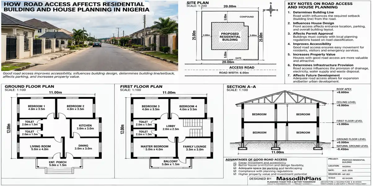
Here’s the thing nobody tells you plainly: your building doesn’t exist in isolation from the road in front of it. The road decides how big a truck can reach your site, how your foundation drains, how safe your family is if there’s ever a fire, what your setback has to be, whether emergency services can reach you, and years down the line how much your house is even worth when you want to sell it.
I’ve watched two identical house designs, same size, same finishing, sell for very different prices simply because one sat on a properly graded, accessible road and the other sat down a narrow, waterlogged lane that turns to soup every rainy season. The building was never the problem in the second case. The road was.
When you go to inspect land, drive to it the way a delivery truck would not on a motorcycle, not on foot. If your own car struggles, imagine a fully loaded block truck or a cement mixer trying the same route.
Road Classification and Why It Changes Your Setback
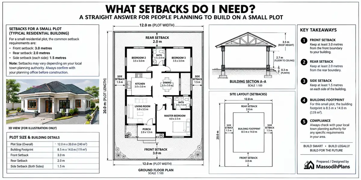
In Nigerian planning practice, roads aren’t all treated the same, and this directly affects how far your building has to sit from the road your setback.
Federal highways typically carry a right of way around 90 metres, requiring roughly 45 metres of setback from the centre line. State highways sit around 60 metres right of way, about 30 metres of setback. Local roads and access streets have much smaller requirements an access road or street is commonly pegged at around 9 metres right of way, with about 6 metres measured from the edges. These numbers vary slightly by state, so always confirm with your local planning authority, but the pattern is consistent everywhere: the bigger and more important the road, the further back you legally have to build.
I mention this because I’ve seen people design a beautiful house right up to their fence line, only to find out during approval that half the frontage they were counting on is actually inside the required setback for the road classification their plot fronts. That’s not a small redesign. That’s often a complete replan of the ground floor.
Don’t assume your setback based on what your neighbour built, or what your builder “always does.” Confirm the actual road classification with your state’s planning authority and get the correct setback in writing before your architect finalizes the design. I’ve had to redraw entire layouts for clients whose builder pushed the house too close to the road line, thinking it was fine it was not, and the correction cost far more than checking upfront would have.
Right of Way: The Silent Threat to Buildings You’ve Already Finished
This is the part that genuinely worries me for clients, because it’s invisible until it isn’t. A right of way is land the government has reserved usually along a road, pipeline, or drainage channel for future expansion or infrastructure. People build on it anyway, sometimes knowingly, sometimes because nobody told them, and it works fine for years. Then the state decides to widen that road, and every structure sitting inside the reserved right of way gets marked for demolition, often with little or no compensation.
I’m not exaggerating the pattern here it’s well documented across Nigerian states. Buildings that ignored road setback and right of way rules have been demolished during road expansion projects in multiple states, and in many of those cases, the affected owners were fully aware of the setback rules but chose to build anyway, gambling that enforcement would never catch up to them. Sometimes it doesn’t, for years. But when it does, there’s no negotiating with a bulldozer.
If you’re buying land near a road that looks “narrow now but will obviously be expanded someday” near a growing town, an emerging commercial corridor, anywhere government has flagged for future infrastructure that instinct is worth taking seriously. Ask directly whether there’s a reserved right of way beyond the current road edge before you build anything permanent close to that line.
How Road Access Affects Your Foundation and Drainage
This is the practical, day-one construction problem that road access creates, and it’s rarely explained clearly anywhere.
If the road leading to your plot is unpaved, poorly graded, or sits lower than your compound, rainwater runs off the road and straight into your site. I’ve been called to sites where the client’s foundation trench filled with water during a single downpour, not because of anything wrong with the plot’s own soil, but because the access road channelled runoff from an entire street directly toward that one compound. In parts of the South-South especially, where rainfall is heavy for a good chunk of the year, this isn’t a minor inconvenience it’s the difference between a foundation that cures properly and one that sits compromised before the walls even go up.
The fix has to happen at the planning stage, not after: your architect and site engineer need to check how water actually moves along your access road and where it goes once it reaches your plot boundary, then design your compound levels and drainage to work with that reality, not against it. Raising your own slab level without checking this just pushes the water problem onto whoever’s plot sits lower than yours usually your neighbour, which creates its own set of disputes.
Truck Access and What It Actually Costs You
Let’s talk money, because this is where road access hits people’s pockets directly and immediately, not in some distant future scenario.
If your access road can’t take a standard delivery truck, every single material block, cement, sand, gravel, roofing sheets, steel has to be offloaded further away and moved to your site by hand, wheelbarrow, or smaller vehicle. That’s not a one-time inconvenience. That’s added labour cost on every single delivery, for the entire construction period. I’ve seen projects where this alone added a meaningful percentage to the total build cost, simply because nothing could drive directly to the site.
Beyond materials, think about the equipment your build might need a concrete mixer, a small excavator for foundation work on a large plot, a crane if you’re doing anything ambitious. None of that reaches a site down a narrow footpath. You either redesign your construction method around manual labour (slower, and often more expensive per unit of work) or you find yourself paying to temporarily widen or reinforce an access path just to get your own project moving money that adds nothing to the finished house.
Before you finalize any land purchase, ask specifically: can a fully loaded block or cement truck reach this plot without reversing, without getting stuck, and without damaging a neighbour’s fence to pass? If the answer involves any hesitation, get that hesitation resolved before you pay, not after.
Emergency Access: The Consideration Almost Nobody Plans For
Nobody wants to think about this while they’re excited about a new building, but I’d rather you think about it now than discover it during an emergency. If there’s ever a fire, a medical emergency, or a security incident, how does help actually reach your house? Can an ambulance or a fire service vehicle physically get down your access road, or does it have to stop somewhere and someone has to run the rest of the way?
I’m not telling you this to scare you I’m telling you because it’s a genuinely solvable planning consideration if you think about it before you build, and a genuinely painful one if you only think about it during an actual emergency. Wide enough turning space, no permanent obstruction blocking the route, a road surface that doesn’t turn impassable in heavy rain these aren’t luxury features. They’re basic safety planning that road access either supports or quietly prevents.
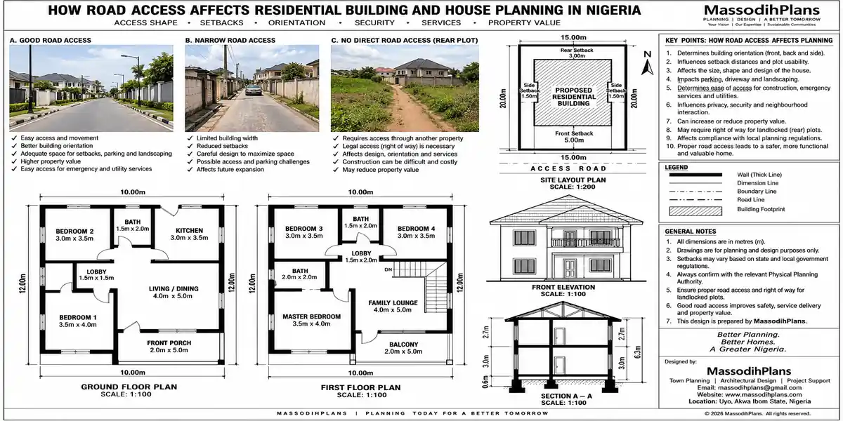
Road Access that can Affects building
Road Access and Property Value: What Actually Happens at Resale
This is where road access stops being a construction concern and becomes a straight financial one. Properties along well-developed roads consistently command higher value than comparable properties on poor or inaccessible roads and the gap isn’t small. Research on residential property values in Lagos found that homes within 100 metres of a major arterial road commanded roughly 20% higher rental value than those sitting further from it. Separate studies across peri-urban Nigerian markets have found land values rising sharply in some documented cases from a few hundred thousand naira to several million naira per plot specifically after road construction reached areas that previously had poor access.
Flip that around, and the lesson is direct: a beautifully built 4 bedroom house sitting down a bad access road will underperform an average house on a good road, every single time, when it comes to resale or rental value. I’ve watched this play out with real clients the building was never the weak point, the road was.
If you’re buying land partly as an investment, don’t evaluate the road as it is today only ask about any planned road projects for the area, and factor in how long the current access situation is likely to last before it improves or, in some cases, gets worse due to increased traffic without matching infrastructure upgrades.
A Real Checklist: What To Actually Check Before You Commit
I’ll give you the exact things I check, or tell my clients to check, before land or a building plan gets approved from my end.
Drive the actual route to the plot with a normal car, at a normal time of day, not just during a dry-season site visit with a motorcycle guide
Confirm the road classification with the local planning authority and get the correct setback distance in writing
Ask directly whether there’s a reserved right of way beyond the visible road edge, especially near any road likely to be expanded
Watch how water moves along the road during or right after rain does it run into the plot, or away from it?
Test whether a loaded delivery truck (block, cement, sand) can reach the plot without reversing or damaging anything
Check turning space and obstruction-free width for an emergency vehicle, not just everyday traffic
Ask neighbours who’ve already built nearby what their actual experience with the road has been during rainy season specifically, not just on a good day
If buying partly as investment, ask about any planned road expansion or upgrade for the area, and how that might change both access and setback requirements later
Conclusion
I’ve spent years watching people fall in love with a plot of land and completely forget to interrogate the road that leads to it. The land is the part everyone photographs and shows off. The road is the part that decides whether your foundation drains properly, whether your materials arrive without extra cost, whether help can reach you in an emergency, and whether your building holds its value ten years from now. Check the road with the same seriousness you check the land, and you’ll avoid the kind of problem that no amount of good architecture can design around after the fact.
If you’re at the land-selection or planning stage, our Services page covers how we help clients evaluate a site road access included before any money changes hands. Browse our Plans Library for designs that account for real Nigerian site conditions, or visit Plan School to understand setbacks, approvals, and the planning process in plain language. You can also explore more practical building guides on our Homepage. Complete this lesson by reading the following articles:
- How GIS and Mapping Can Improve Residential Site Planning in Nigeria Today
- How to Read a Satellite Image Before Buying Land in Nigeria: Full Guide
- How GIS Can Help Identify Flood-Prone Areas Before You Build in Nigeria
- How to Analyse Your Plot Using Satellite Imagery Before Building a House
- How to Use Satellite Maps to Study Land Before Buying Property in Nigeria
Related Guides
- Semi-Detached House Plans: Modern Duplex and Bungalow Designs With Shared Walls, Dimensions, Costs and Layout Ideas
- Courtyard House Plans: Beautiful 2–6 Bedroom Designs With Private Outdoor Spaces, Floor Plans and Dimensions
- Contemporary House Plans: Modern 2–6 Bedroom Designs With Open Layouts, Large Windows, Dimensions and Costs
- House Finishing Cost in Nigeria: Complete Breakdown of Tiles, Painting, Ceiling, Doors, Plumbing and Electrical Work
- Foundation Cost Calculator: Estimate House Foundation Cost From Soil Type, Dimensions, Materials and Labour
- Block Quantity Calculator: How to Calculate the Number of Blocks Needed for Any House From Your Floor Plan
- Cement Quantity Calculator for Building: Calculate Bags Needed for Foundation, Blockwork, Slab, Plastering and Screeding
- Self-Contained House Plans: 15 Efficient Designs With Room Dimensions, Floor Plans, Building Costs and Ideas
- 1 Bedroom House Plan: Affordable Self-Contained Floor Plans With Dimensions, Materials, Cost and Space-Saving Ideas
- 6 Bedroom House Plans: Modern Nigerian Floor Plans With Dimensions, Ensuite Rooms, Parking and Cost Estimates
Author
Massodih Okon is a Nigerian built-environment professional with academic and professional experience in urban and regional planning, geography, architectural design, Landscape Design, GIS and land development.
He holds a Master’s degree in Urban and Regional Planning from the University of Uyo and a first degree in Geography and Regional Planning.
Through MassodihPlans, he publishes practical guides on Nigerian house plans, building design, physical planning, site planning, development approval and residential construction. Read the full author profile →