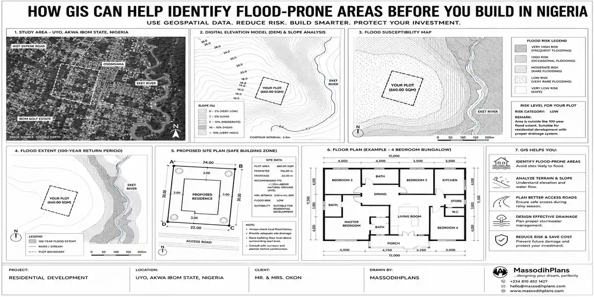
How GIS Can Help Identify Flood-Prone Areas Before You Build in Nigeria
I want you to picture something first, because it’s the reason I’m writing this.
A family buys a plot. The agent shows them the land in December dry season, dust everywhere, nothing but bush and a “for sale” board. It looks perfect. They pay, they build, they move in with all their savings gone into the walls. Then July comes. The first heavy rain of the season, and water is sitting ankle-deep in their compound for three days. By September, it’s happened twice more. Nobody warned them, because nobody actually checked not the agent, not the family, not anyone whether that land sits in a natural drainage path.
I have seen this exact story too many times in my years doing this work, in different states, with different families, always with the same root cause: the land was checked for the title (survey, C of O, family consent) and never checked for water. This article exists to close that gap, and I’m going to show you exactly how, using tools that are mostly free and steps you can genuinely do yourself before you spend a single naira on land.
First, Let’s Be Clear About What GIS Actually Is
You don’t need to become a GIS analyst to use this information. GIS Geographic Information System is simply a way of layering different data about a location on top of each other: elevation, rainfall, rivers, soil type, land use, drainage channels. Instead of looking at a plot in isolation, GIS lets you look at it in context how high or low it sits, where water naturally wants to go, what’s upstream and downstream of it.
Professionals use expensive software to do deep flood modeling. But you, as someone about to buy land, don’t need that level of depth. You need to answer three practical questions:
- Is this plot lower than the land around it?
- Where does water go when it rains, and does it pass through here?
- Has this specific spot flooded before, and how badly?
Everything in this guide is built around answering those three questions using tools that are already sitting on your phone or laptop.
Question 1: Is This Plot Lower Than the Land Around It?
Water always moves from high ground to low ground. This is the single most important physical fact in this entire article, and almost every flood-prone plot I have ever assessed shares one thing: it sits in a local low point relative to its surroundings, even where the difference is small.
Using Google Earth Pro to Check Elevation (Free)
Download Google Earth Pro on your laptop it’s free, not the mobile app. Once you have your plot’s coordinates (from your survey plan) or you can locate it visually:
- Search the coordinates or navigate to the location
- Hover your cursor over the plot and note the elevation reading shown at the bottom of the screen
- Do the same for the surrounding streets and neighbouring plots in a 200-500 metre radius
- Use the “Ruler” tool to draw a line from your plot to the nearest stream, river, or major drainage channel, then use the elevation profile feature to see whether the ground rises or falls along that line
If your plot reads noticeably lower than the surrounding area, or if the elevation profile shows a steady drop from your plot toward a nearby water body, you are looking at a location where water naturally wants to travel — and it doesn’t ask permission before it does.
Don’t just check the plot itself check a rough circle around it, at least 300-500 metres out. A plot can look level on its own and still be the lowest point in its immediate neighbourhood, which is exactly where water collects during heavy rain.
Reading Contour Lines on a Topographic Map
If you can get hold of a topographic map for the area (some state ministries of lands and survey departments issue these, and university geography departments often have them for research purposes), contour lines tell you the same story more precisely. Closely spaced contour lines mean steep slope; widely spaced or absent contours around your plot mean flat, low-lying ground the terrain type most associated with waterlogging and flood risk in Nigerian towns and cities.
Question 2: Where Does Water Go When It Rains?
This is about tracing drainage patterns, not just elevation. A plot can sit at a reasonable height and still be directly in the path of a natural drainage channel, a seasonal stream, or a floodplain that’s dry most of the year and dangerous for two or three months.
Free Satellite Imagery to Spot Drainage Patterns
Beyond Google Earth’s standard view, look at historical imagery (Google Earth Pro has a “time slider” feature showing older satellite images of the same location). Rainy-season imagery, where available, often reveals visible standing water, waterlogged vegetation patterns, or a stream channel that’s invisible in dry-season photos. If you can find even one rainy-season satellite image of your target area, compare it against the dry-season image the agent showed you.
Nigeria’s Own Flood Data Sources
The Nigeria Hydrological Services Agency (NIHSA) publishes an Annual Flood Outlook every year, identifying local government areas and communities at high, moderate, and low flood risk based on rainfall projections and river levels. It’s public information, usually covered by Nigerian news outlets around April-May each year before the rainy season starts. Before you commit to land anywhere, search for the current year’s NIHSA flood outlook and check whether your target LGA appears on the high-risk list.
Several states also maintain their own GIS portals with layers for drainage infrastructure and flood-prone zoning Lagos State’s land information systems and similar platforms in other states are worth checking directly, since they reflect local government’s own flood risk classification for planning purposes.
Tracing the Drainage Channel Physically
On your site visit, don’t just look at the plot walk its boundaries and look for:
- A dry, sunken channel or depression running through or near the plot often overgrown with grass and easy to mistake for ordinary bush, but frequently a seasonal watercourse
- Culverts, drainage pipes, or concrete channels nearby, and which direction they run
- Whether the plot sits noticeably lower than the road it fronts a very common and easy-to-miss warning sign, because roads are often built up while surrounding land is left at its natural (lower) level
If you find a natural or man-made drainage channel running through or beside your plot, do not assume you can simply fill it in or divert it. In most Nigerian states this requires separate approval, and blocking a drainage path illegally is one of the fastest ways to create flooding for yourself and every neighbour downstream of you it can also expose you to demolition orders later.
Question 3: Has This Specific Spot Flooded Before?
Data and satellite imagery matter, but nothing beats the memory of people who have actually lived through a rainy season on that exact land.
Talk to People Who Have Been There Longest
Find the oldest residents near the plot not the agent, not the person selling and ask directly: “Does water enter this area when it rains heavily? How far does it reach? Which years were the worst?” People who have lived somewhere for 15-20 years remember flood years with striking precision, because it’s the kind of thing that damages property and disrupts lives. This single conversation has saved more of my clients from bad purchases than any map I’ve shown them.
Look for Physical Evidence on the Ground
Watermarks or staining on the lower sections of nearby walls and fences a faint but visible line showing how high water has risen in the past
Existing houses nearby built with an unusually high plinth (the base of the building raised well above ground level) builders in genuinely flood-prone areas often do this deliberately, and it’s a strong signal even if nobody tells you why
Cracks or erosion at the base of nearby structures, which can indicate repeated water exposure
Dead or stressed vegetation patterns that suggest waterlogging, versus healthy vegetation that suggests good drainage
Check News Archives
A quick search for the community or LGA name plus “flood” will often surface local news coverage from past rainy seasons. Nigerian flood events, especially significant ones, tend to get local press coverage and a pattern of repeated coverage for the same area across multiple years is a red flag no satellite image will show you as clearly.
Soil Type Matters Almost as Much as Elevation
Two plots at the same elevation can behave very differently in heavy rain depending on what’s underneath them.
Sandy, well-draining soil absorbs water relatively quickly and is generally lower risk, common in parts of the drier interior and some coastal ridge areas
Clay-heavy or compacted soil holds water at the surface far longer, increasing waterlogging even where the land isn’t in a strict floodplain
Reclaimed or filled land (common in parts of Lagos, Port Harcourt, and other coastal cities where swampy land has been sand-filled for development) can look solid on the surface but retain the poor drainage characteristics of the original wetland underneath, especially where the fill wasn’t properly compacted
A simple soil test, which you should be getting before construction anyway for foundation design purposes, will also give you a practical read on drainage characteristics — ask your soil engineer directly about permeability and water table depth, not just bearing capacity.
When to Bring in a Professional Flood Risk Assessment
Everything above is genuinely something you can do yourself before committing to a purchase, and I’d encourage every single person reading this to actually do it rather than skip to the professional step. But there are situations where paying for professional input is worth it:
The plot is in a coastal, riverine, or historically flood-affected LGA, even if your own checks look reasonably clear
You’re investing a large sum and want a second, technical opinion before committing
The land is reclaimed or filled, and you want an actual assessment of fill quality and drainage capacity, not just a visual check
You’re building for diaspora clients who can’t do the ground checks (talking to neighbours, walking the boundaries) themselves
A professional flood risk and site suitability assessment, combining elevation survey, drainage analysis, and soil testing, typically costs a small fraction of what a single flood event will cost you in damage and rebuilding this is one expense I never advise clients to skip on genuinely borderline sites.
A Practical Pre-Purchase Checklist
Before you pay for any plot, walk through this list. If more than two or three of these raise concerns, treat it as a serious warning, not a minor detail to “manage later”:
- Elevation relative to surrounding land, checked via Google Earth Pro or a topographic map
- Distance and elevation change to the nearest stream, river, or major drainage channel
- Whether the plot sits lower than the road fronting it
- Presence of a dry or overgrown channel/depression on or near the plot
- Whether the LGA appears on the current year’s NIHSA flood outlook
- Direct conversation with long-term residents about past flooding
- Physical evidence: watermarks, raised plinths on nearby buildings, erosion, vegetation stress
- Soil type and whether the land is natural ground or reclaimed/filled
- Whether the plot falls within a designated drainage easement or floodplain according to the relevant state planning authority
Do this checklist during the rainy season if you possibly can, or at least visit right after a heavy rain. A plot that looks perfectly dry and solid in January can tell you an entirely different story after two hours of downpour in July and that difference is exactly what you need to see before you buy, not after.
Common Myths That Get People Into Trouble
“The water always recedes, so it’s fine.” Recession doesn’t mean the flooding was harmless it means your foundation, walls, and electrical systems were still exposed to standing water, with cumulative damage that shows up over years, not instantly.
“Everyone around here has the same problem, so it’s normal.” Widespread flooding in an area is not a reason to accept the risk it’s confirmation that the risk is real and shared, which should make you more cautious, not less.
“We’ll just raise the land before building.” Raising a plot’s ground level is a legitimate mitigation in some cases, but it has to be engineered properly and it can, if done carelessly, simply push the flooding problem onto your neighbours which creates a different kind of serious problem for you.
“GIS and flood mapping are only for government and big companies.” As this guide has shown, most of the meaningful checks are things any individual buyer can do with free tools and a site visit you don’t need institutional access to protect yourself here.
Finally
The honest truth is that most flood damage I have seen in residential buildings was preventable at the land-buying stage, not the construction stage. By the time a house is built, your options for dealing with a bad site are expensive and limited raised foundations, expensive drainage engineering, or simply living with recurring damage. At the land-buying stage, your options are simple and mostly free: check the elevation, trace the drainage, ask the people who’ve lived there, and look at the ground with your own eyes.
Do this before you pay for any plot, not after. It’s the cheapest insurance policy available to you in this entire process.
If you’re at the land selection stage and want direct support reviewing a specific site, our Services page outlines how we assist with site assessment before you commit to a purchase. Browse our Plans Library for designs that account for site-specific drainage and foundation needs, or visit Plan School to understand how site conditions shape a building plan before construction begins. You can also explore more land-buying and site-planning guides on our Homepage. See approval conditions in Lagos
- How to Analyse Your Plot Using Satellite Imagery Before Building a House
- How to Use Satellite Maps to Study Land Before Buying Property in Nigeria
- How Wind Direction Can Influence House Planning and Natural Ventilation
- How Sun Orientation Affects Residential Building Design in Nigeria Today
- How Nigeria’s Climate Should Influence Your House Design and Site Planning
- How Natural Water Flow Can Affect Your Building Site and House Plan Today
Author
Massodih Okon is a Nigerian built-environment professional with academic and professional experience in urban and regional planning, geography, architectural design, Landscape Design, GIS and land development.
He holds a Master’s degree in Urban and Regional Planning from the University of Uyo and a first degree in Geography and Regional Planning.
Through MassodihPlans, he publishes practical guides on Nigerian house plans, building design, physical planning, site planning, development approval and residential construction. Read the full author profile →