How to Analyse Your Plot Using Satellite Imagery Before Building a House
Let me tell you what I see most often when a client brings me a plot they’ve already bought: a survey plan, a receipt, sometimes a C of O, and absolutely no idea what that land actually looked like five years ago. Not what it looks like now what it looked like before someone filled it, before someone built a fence around it, before the agent showed it to them on a dry-season afternoon when everything looked solid.
That gap between “what the land looks like today” and “what the land actually is” is where I’ve seen more money lost than almost anywhere else in the building process. And the tool that closes that gap costs nothing and takes fifteen minutes to use properly. It’s satellite imagery. Not the pretty top-down photo everyone screenshots for their WhatsApp status the historical, multi-layered kind that actually tells you something.
This isn’t going to be another “here’s how to find your house on Google Maps” article. I want to walk you through this the way I’d walk a client or a GIS student through it, because if you’re about to commit tens of millions of naira to a plot, you deserve to actually understand what you’re looking at, not just be told to “go and check Google Earth.”
Why This Matters More in Nigeria Than Almost Anywhere Else
In a lot of countries, land records are digitized, floodplain maps are public, and a building inspector will simply reject your application if your plot sits in a known flood zone. That safety net barely exists across most of Nigeria. The burden of finding out what your land really is falls almost entirely on you, before you buy, and definitely before you build.
I have walked plots in areas around Uyo and Port Harcourt where the surface looked completely dry and buildable sand-filled, fenced, sometimes with a caretaker’s shed already on it and satellite history showed the same spot as open water or thick swamp vegetation just three or four dry seasons earlier. Sand-filled swamp doesn’t become solid ground because someone poured sand on it. It becomes a foundation problem waiting for the first heavy rainy season, and by then you’ve already built.
This is the real problem satellite imagery solves. Not “is this a nice-looking plot” you don’t need a satellite for that, your eyes do that job. Satellite imagery answers questions your eyes physically cannot: what was here before, where does water actually go, has this area been slowly shrinking or eroding, and does what you’re being shown match what’s actually there.
What You Actually Need (And What You Don’t)
You do not need commercial-grade imagery, a paid subscription, or GIS software training to do a genuinely useful plot analysis. Here’s the honest toolkit:
Google Earth Pro (free, desktop) this is your main tool, and the historical imagery slider inside it is the single most underused feature in Nigerian land-buying
Google Earth on your phone or browser fine for a quick look, but the historical timeline is far more limited than the desktop Pro version
EO Browser by Sentinel Hub (free) for anyone who wants to go a step further and actually see vegetation and moisture patterns, not just a photo
Your survey plan with coordinates without this, you’re just eyeballing a location, not verifying one
A phone with GPS, on-site because satellite analysis without ever standing on the actual plot is incomplete, and I’ll explain why later
You genuinely do not need paid VHR (very high resolution) commercial tasking services that some blogs push hard. Those are built for people monitoring construction progress on an existing project or resolving a legal boundary dispute not for someone about to buy or build on a plot. Save that money for your soil test instead.
If a platform is trying to sell you a paid satellite report before you’ve even used the free historical slider in Google Earth Pro, you’re being sold a solution to a problem you haven’t confirmed you have yet. Start free. Only pay if the free tools genuinely can’t answer your specific question.
Step 1: Locate Your Plot Precisely Not Roughly
This sounds obvious, and it’s exactly where most people get it wrong. Typing a rough address or a landmark description into Google Earth and eyeballing “somewhere around here” is not plot analysis it’s guesswork with extra steps.
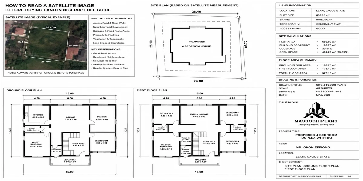
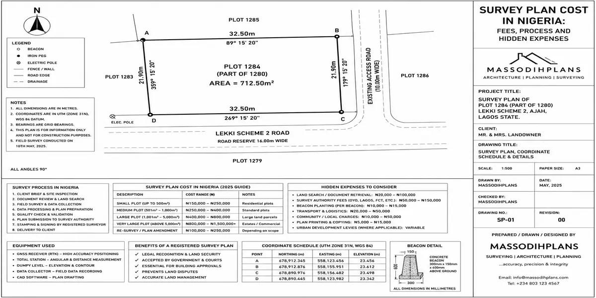
Get the coordinates from your survey plan. Every Nigerian survey plan carries coordinate values (usually in the Universal Transverse Mercator system, referenced to the Minna Datum) for the plot’s corner beacons. Ask your surveyor for these in a format you can actually paste into Google Earth decimal degrees is easiest. Paste those coordinates directly into the search bar. That drops you on the exact corner of your plot, not a general neighbourhood.
If your survey plan only shows beacon numbers without usable coordinates, that’s worth flagging with your surveyor before you go further a plan you can’t geolocate precisely is harder to defend later if a boundary dispute ever arises.
Step 2: Pull the Historical Timeline This Is Where the Real Story Is
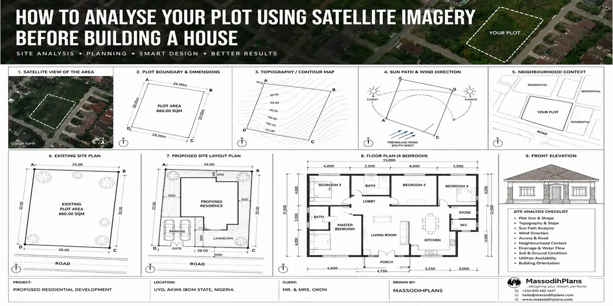
Once you’re sitting on your exact plot in Google Earth Pro, click the clock icon in the toolbar. This opens a slider showing every historical satellite capture available for that location, sometimes going back 15-20 years.
Drag it all the way back and walk forward through time, year by year. This is not a formality this is the actual investigation. Here’s what you’re specifically looking for:
Was this land ever water, swamp, or dense vegetation?
If an area that’s now a dry, sand-filled plot was clearly open water or thick mangrove/swamp vegetation a decade ago, you are not looking at “land” you’re looking at reclaimed land, and reclaimed land needs a different foundation approach entirely. This single check would have saved several clients I’ve worked with from a foundation redesign they only discovered they needed after cracks appeared.
How fast did the surrounding area develop?
If a location went from bush to a handful of buildings to dense, wall-to-wall construction within five or six years, that tells you infrastructure roads, drainage, power is very likely lagging behind the building density. That’s useful to know before you build, not after your compound floods every rainy season because the drainage was sized for the “before” picture, not the “now.”
Has the plot’s shape or boundary changed?
Compare the plot’s visible boundary today against its boundary five or ten years ago. If the fenced area has visibly grown, shrunk, or shifted relative to the surrounding plots, that’s a conversation you need to have with your surveyor and your seller before you build not after.
If historical imagery shows your plot as open water or swamp within the last decade, do not treat a soil test as optional or “just a formality to get the loan approved.” Reclaimed land specifically needs a geotechnical soil test to determine whether you need a raft or pile foundation, and skipping it here is one of the most expensive mistakes I’ve seen people make.
Step 3: Trace Where the Water Actually Goes
This is the step almost nobody does, and it’s the one that would prevent the most flooding complaints I hear from homeowners two or three rainy seasons after they’ve moved in.
Zoom out from your plot until you can see the surrounding drainage channels, streams, or low-lying areas usually visible as darker, vegetated lines cutting across the landscape, or as visible concrete/earth drainage channels along roads. Follow them. Where do they lead? Does your plot sit directly in the path of a natural drainage line that’s simply not visible when you walk the dry plot yourself?
A plot can look perfectly flat and dry on a site visit and still sit in what is, functionally, a natural water channel that only becomes obvious in the peak of the rainy season. Satellite imagery captured during or shortly after heavy rains which you can sometimes catch in the historical timeline if you’re lucky with capture dates will show standing water or waterlogging patterns that a dry-season visit will never reveal.
If you have access to EO Browser, this is where the NDWI (Normalized Difference Water Index) layer becomes genuinely useful it highlights moisture and water presence across an area far more precisely than a plain photo can, without needing any technical GIS background to read it. You’re just looking for whether your plot lights up as “wet” in that layer during rainy periods.
Step 4: Check What’s Actually Around You, Not What You Were Told Is Around You
Agents describe surroundings the way that helps close a sale. Satellite imagery describes surroundings the way they actually are.
Look for what’s genuinely within the immediate vicinity of your plot: how close is the nearest major drainage channel or stream, is there an existing or planned road that current imagery hasn’t caught up with yet, how dense is the existing building pattern, and critically is there any sign of industrial activity, waste dumping, or quarrying nearby that wouldn’t come up in a casual conversation with a seller eager to close a deal.
I’ve also used this step to verify something sellers are sometimes vague about deliberately: whether a plot genuinely has direct road access, or whether that “access road” shown in a sales layout actually exists on the ground yet, versus existing only on a proposed master plan. Satellite imagery doesn’t lie about whether a road has actually been cut and is in use a proposed road on a glossy layout brochure and an actual road visible from space are two very different things.
Step 5: Confirm Elevation and Slope
Google Earth Pro shows elevation data as you move your cursor across the terrain, and this matters more than most first-time builders realize. A plot sitting noticeably lower than its immediate surroundings is a plot that water will naturally drain toward regardless of how good your compound’s own internal drainage design is. You are, in effect, downstream of your neighbours whether you like it or not.
This doesn’t automatically disqualify a plot plenty of homes are successfully built on lower-lying land but it changes what you need to budget for: proper compound elevation with fill, a robust perimeter drainage design, and a foundation approach that accounts for the water table being closer to the surface than on higher ground nearby.
Step 6: Cross-Check Against the Ground Because Satellite Analysis Alone Isn’t Enough
I want to be honest about something most articles selling satellite tools won’t tell you: imagery, however good, is not a replacement for standing on your actual plot. It’s a preparation tool that tells you what to specifically look for and ask about once you’re physically there.
When you visit the site in person, go with the questions your satellite analysis raised, not a blank mind. If the historical imagery showed swamp a decade ago, ask specifically about fill history and depth when you’re there not generally “is the ground good,” which any seller will answer “yes” to regardless. And if you traced a drainage line running near the plot, walk that exact line on the ground and see whether it’s dry, seasonal, or currently flowing. If the imagery showed a road that looks unfinished or informally cut, walk it and see whether it’s actually motorable or just a cleared path.
Bring your phone’s GPS and your survey coordinates with you on the site visit. Standing exactly where your satellite analysis says the water channel crosses, or exactly where the reclaimed-swamp boundary sat a decade ago, turns an abstract satellite observation into something you can physically point at and discuss with your builder or surveyor on the spot.
A Worked Example: How This Actually Plays Out
Picture a fairly typical scenario I’ve encountered in variations more than once: a plot in a fast-developing peri-urban axis, fenced, sand-filled, with a caretaker already living in a small structure on one corner. On the ground, it looks completely ordinary dry, level, no obvious red flags.
Pulling the historical timeline back eight to ten years shows something the site visit never could: the same location sitting under visible standing water for a good portion of the year, with the surrounding “developed” area still mostly open swampland at that point. Following the drainage pattern outward shows a natural channel running along what is now the plot’s rear boundary currently dry-looking on the surface, but clearly the historical path water took before the whole area was filled and built up.
None of that shows up walking the plot in the dry season with an agent standing beside you, smiling, telling you the ground is solid. All of it shows up in fifteen minutes of historical imagery review, before a single naira changes hands. That’s the actual value here not a nice satellite photo for your files, but specific, actionable red flags you can raise before you buy, before you design, and definitely before you build.
Common Mistakes People Make With Satellite Plot Analysis
Only looking at the current image, never the historical timeline the current photo shows you the disguise; the history shows you what’s underneath it
Trusting a rough address search instead of precise survey coordinates you can end up analysing the wrong plot entirely without realizing it
Treating satellite analysis as a replacement for a soil test, rather than a reason to specifically request one when the imagery raises a red flag
Ignoring elevation relative to immediate neighbours, then being confused later about why water always seems to head toward the compound
Never walking the site with the specific questions the imagery raised, and instead accepting generic reassurance from a seller
Frequently Asked Questions
Is satellite imagery accurate enough to replace a proper land survey?
No. Satellite imagery is a preparation and investigation tool it tells you what questions to ask and what to verify. Your legal boundary confirmation still depends on a proper survey plan and, ideally, a licensed surveyor’s physical beacon verification.
How far back can I check a plot’s history for free?
Google Earth Pro’s historical imagery can go back 15-20 years in many areas, though coverage frequency and image quality vary significantly by location and year some years may have only one or two usable captures for a given spot.
Can satellite imagery tell me if a plot floods?
It can strongly suggest it through visible standing water in past captures, drainage-line proximity, and elevation relative to surroundings but confirming actual flood behaviour also benefits from asking neighbours who’ve lived through at least one full rainy season on the axis.
Do I need paid satellite imagery services for a residential plot?
For almost all residential plot analysis, no. Free tools (Google Earth Pro, EO Browser) provide everything covered in this guide. Paid, very-high-resolution tasking is built for ongoing construction monitoring or active legal disputes, not pre-purchase due diligence.
What do I do if satellite imagery shows my plot was previously swampland?
Don’t panic and don’t abandon the plot automatically many reclaimed plots are built on successfully. Get a proper geotechnical soil test before finalizing your foundation design, and budget for a raft or pile foundation rather than assuming a standard strip foundation will do.
Conclusion
The gap between what a plot looks like and what a plot actually is, is exactly the gap satellite imagery is built to close and it costs you nothing but fifteen focused minutes before you commit real money. Pull the history, trace the water, check the elevation, then walk the ground with the specific questions that analysis raised. That order matters. Skipping straight to the site visit, the way most people do, means you’re only ever seeing the disguise the dry season and the seller are both currently showing you.
If you’re at the plot-buying or pre-design stage, our Services page covers how we support clients through exactly this kind of due diligence before drawings even begin. Browse our Plans Library once your site is confirmed and you’re ready to move into design, or visit Plan School for more on reading survey plans and site documentation. You can also explore more land and site-analysis guides on our Homepage.
Related Articles
- How to Use Satellite Maps to Study Land Before Buying Property in Nigeria
- How Wind Direction Can Influence House Planning and Natural Ventilation
- How Sun Orientation Affects Residential Building Design in Nigeria Today
- How Nigeria’s Climate Should Influence Your House Design and Site Planning
- How Natural Water Flow Can Affect Your Building Site and House Plan Today
- How Drainage Should Influence Your House Site Planning in Nigeria Today
- How Topography Influences Flooding Around Nigerian Homes and Cities Today
- How to Understand Land Use Before Buying Property in Nigeria Safely
- How Land Use Affects the Type of Building You Can Develop in Nigeria Today
- 10 Things to Check Before Building a House on Any Plot in Nigeria Today
- How to Evaluate Land in Lagos Before Choosing a House Plan to Build Safely (15 Best Ways)
- How to Choose the Right Residential Location in Abuja Before You Build (20 Best Areas Ranked for Buildability)
- How to Choose the Right Residential Location in Lagos Before You Build
- 10 Best House Plans for Small Plots in Nigeria: What Buyers Should Consider
- How to Choose the Right House Plan Based on Your Plot Size in Nigeria Today
- How GIS Can Help You Choose the Right Land for Your Dream House in Nigeria
Author
Massodih Okon is a Nigerian built-environment professional with academic and professional experience in urban and regional planning, geography, architectural design, Landscape Design, GIS and land development.
He holds a Master’s degree in Urban and Regional Planning from the University of Uyo and a first degree in Geography and Regional Planning.
Through MassodihPlans, he publishes practical guides on Nigerian house plans, building design, physical planning, site planning, development approval and residential construction. Read the full author profile →