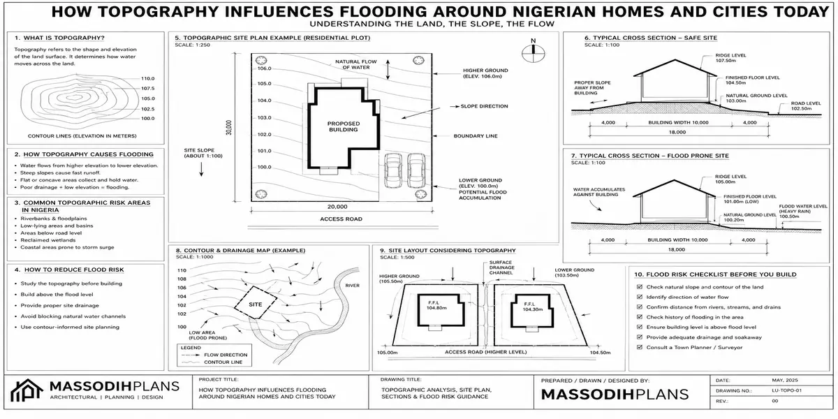
How Topography Influences Flooding Around Nigerian Homes and Cities Today
If you have ever wondered why one Nigerian house stays relatively dry while another house a few streets away is surrounded by floodwater, the answer may begin beneath your feet. Topography the elevation, slope, shape and drainage pattern of the land determines where rainwater travels, where it slows down, and where it eventually collects.
In simple terms, water moves downhill. But Nigerian flooding is rarely caused by elevation alone. A low-lying plot, gentle slope, concave ground, blocked drainage channel, paved surface, nearby river or poorly planned road can combine to turn ordinary rainfall into flooding. Recent Nigerian flood-susceptibility studies continue to identify elevation, slope, drainage, distance to water bodies and land-use change as important controls, while current national warnings show that saturated soils and inadequate drainage can rapidly increase urban flood risk.
This is why buying a plot because it “looks flat,” raising a building without studying surrounding levels, or placing a house directly across a natural flow path can create problems that become obvious during heavy rain.
In this guide, I will show you how topography influences flooding around Nigerian homes and cities from the contour lines on a survey plan to the finished floor level of a building. We will look at high and low ground, slope direction, valleys, depressions, floodplains, runoff paths, drainage, road levels, and the relationship between neighbouring properties. More importantly, I will explain how these factors should influence site planning, building orientation, platform levels and drainage design before construction begins.
Whether you are a homeowner, student, developer, architect, town planner, surveyor or someone about to buy land, this guide will help you read the land differently and make informed decisions before the next heavy rainfall tests your property.
What Topography Actually Means for a Homeowner
Topography is simply the shape and elevation of land its hills, slopes, valleys, and flat stretches. For flooding purposes, three topographic features matter far more than the others:
Elevation how high a piece of land sits relative to sea level or a nearby water body. Lower elevation generally means water arriving from higher ground has to go somewhere, and “somewhere” is often your compound.
Slope/gradient how steeply land rises or falls. Steep slopes shed water quickly (sometimes too quickly, causing erosion and flash flooding downstream). Flat or near-flat land gradients below roughly 1%, which describes large stretches of Nigeria’s coastal and inland lowlands doesn’t shed water efficiently at all. It just sits there, ponding, until it evaporates, soaks in, or is pumped/drained away.
Basin position whether your land sits inside a natural drainage basin (a bowl-shaped catchment where water from surrounding higher ground converges) or on a ridge or watershed line that sheds water outward instead of collecting it.
None of these three features are visible from standing in your compound looking around. They only become obvious when you look at the land at a wider scale which is exactly why so many people build without ever checking them.
Before buying land, open Google Earth, search your plot’s coordinates, and check the elevation reading in the bottom-right corner. Then check the elevation of the surrounding area within a 1–2 km radius. If your plot’s number is noticeably lower than its surroundings, you’re likely sitting in a natural catchment point and that single five-minute check can save you from a decade of flooding.
Why Flat Land Floods More Than Sloped Land Even With Less Rain
This surprises a lot of people, because sloped land intuitively feels riskier. In practice, the opposite is often true for standing-water flooding.
On a slope, gravity does the work rainwater runs off toward lower ground quickly, and unless that lower ground is your own compound, the water simply passes through and away. On flat land, there is no gravitational push. Rain falls, has nowhere obvious to go, and accumulates until it either soaks into the soil, evaporates, or is actively removed by a drain, canal, or pump.
Nigeria’s topography is predominantly flat to gently undulating plains and plateaus below 600 metres elevation, with coastal deltas and inland basins exhibiting minimal slopes of less than 1% that impede runoff and promote ponding. This single geographic fact explains more about Nigerian urban flooding than almost any other single variable it’s why cities across such different climate zones (Lagos on the coast, Onitsha inland, Ibadan further north) all share a common flooding vulnerability rooted in shared topographic flatness, not just shared rainfall totals.
This is also why “it didn’t used to flood here” is such a common and misleading observation. Flat land doesn’t need a dramatic topographic feature to flood badly it just needs its natural, slow drainage pathways blocked or overwhelmed, which brings us to how topography and human development interact.
How Topography and Urban Development Compound Each Other
Topography alone rarely causes catastrophic urban flooding. It’s topography combined with how a city is built on top of it that turns manageable rainfall into disaster.
Natural Drainage Paths Get Built Over
Every landscape, however flat, has natural low points and shallow channels where water has always moved during heavy rain even if no visible stream is there most of the year. As cities expand, these natural paths get filled, built on, or fenced off, because they don’t look like anything special in the dry season. The water doesn’t stop trying to use that path. It just now has a building, a fence, or a road sitting in the way.
Impervious Surfaces Remove the Land’s Natural Absorption
Undeveloped flat land, however slow-draining, still absorbs a meaningful amount of rainfall into the soil. Concrete paving, tarred roads, and building footprints remove that absorption almost entirely, converting what used to be partially absorbed rainfall into 100% surface runoff runoff that then has to find somewhere to go across land that, per the point above, was never good at moving water quickly in the first place.
Elevated Roads and Compounds Redirect Water Onto Neighbours
Because flat land has no natural gravitational drainage advantage, small elevation differences created by construction a compound sand-filled a metre above street level, a road raised during resurfacing become the deciding factor in where water goes locally. Raise your compound, and floodwater that would have distributed across the area instead concentrates on whichever neighbouring plot is now the new lowest point. This is one of the most common causes of “my neighbour built and now I flood” disputes I encounter in site consultations, and it is a direct, mechanical topographic effect, not bad luck.
Drainage Infrastructure Sized for the Wrong Topography
Drains and canals are engineered assuming a certain volume of water needs to move through a given gradient. When flat urban areas are developed at a density and impervious-surface ratio beyond what the original drainage design anticipated, the infrastructure even when well-maintained is simply undersized for the volume of runoff now generated. This is a widespread pattern across rapidly developed Nigerian urban districts, where drainage systems designed decades ago now serve several times the built-up density they were sized for.
Never assume a drain running past your plot has spare capacity just because it looks empty in the dry season. Ask your local planning or drainage authority (or a qualified engineer) whether the drainage network serving your area was designed for current development density in many rapidly urbanized Nigerian districts, it was not, and that gap is invisible until the first serious rainfall.
Topography in Practice: How Nigerian Cities Differ
Understanding the general mechanics is useful, but topography plays out differently across Nigerian cities depending on their specific geography and this is the part most flooding content skips in favour of generic advice.
Lagos: Coastal Lowland Under Compound Pressure
Lagos’s low elevation and topography, combined with being surrounded by aquatic ecosystems, significantly increase its susceptibility to flooding a vulnerability serious enough that the state has been ranked among the world’s cities most exposed to extreme sea levels, with its flood exposure projected to worsen substantially by the 2070s. Much of Lagos sits at or barely above sea level, meaning tidal influence and rainfall-driven flooding can compound each other, and reclaimed or filled land (common across many newer Lagos developments) often has particularly poor natural drainage characteristics regardless of how solid it looks once built on.
Port Harcourt and the Niger Delta: Low Gradient, High Water Table
Much of the Niger Delta region shares Lagos’s low-elevation, low-gradient profile, compounded by a naturally high water table meaning the ground is often already saturated before rainfall even begins, leaving little capacity for additional absorption. In this context, topographic depressions fill fast and drain slowly, and seasonal flooding patterns tend to track very closely with the region’s natural low-lying pockets, filled land areas, and reclaimed swamp sites.
Onitsha and the Lower Niger Basin: River Proximity Meets Undulating Terrain
Onitsha’s flood risk illustrates a different topographic pattern digital elevation modelling of the area reveals undulating terrain with varying slopes and elevations, and this terrain data is directly used to simulate water movement and predict flood patterns across specific commercial and residential districts. Unlike Lagos’s broad coastal flatness, Onitsha’s risk is more localized: some districts sit measurably lower than others within the same city, which is why flood severity in the same rainfall event can vary sharply between neighbourhoods just kilometres apart.
Ibadan: Localized, Intense Rainfall Meets Constructed Waterways
Ibadan’s flooding history highlights how topography interacts with tropical rainfall patterns specifically tropical rainstorms are typically highly localized, intense, and short in duration, often covering less than 10 square kilometres, and this intensity combines with topography, land cover, and blocked or diverted natural drainage to produce sudden, severe local flooding. This matters for homeowners because it means a plot can be topographically low-risk on paper and still flood severely if it happens to sit directly under one of these highly localized intense rainfall cells with nowhere for that concentrated water to go.
Kano and Northern Nigeria: Flat Terrain, Different Drainage Culture
Research on flood risk in Kano City identifies surface topography, torrential rainfall, and inadequacies in drainage infrastructure and drainage management as core flood drivers, showing that even in Nigeria’s drier northern climate, flat surface topography combined with drainage infrastructure gaps produces the same fundamental flooding mechanics seen in the wetter south proof that topography’s role in flooding isn’t a coastal-city issue alone, but a nationwide one shaped by the country’s broadly flat terrain.
How to Check a Plot’s Topographic Flood Risk Before You Build
This is the section most flooding articles never get to, because most are written to explain the problem, not to help an individual homeowner act on it. Here is a practical sequence.
Step 1: Check Elevation Relative to Surroundings
Use Google Earth or a similar mapping tool to check your plot’s elevation reading, then compare it against points 500m–2km away in multiple directions. A plot sitting noticeably lower than its surroundings is a basin position water from the higher ground around it has to go somewhere, and gravity says it comes toward you.
Step 2: Identify the Nearest Natural or Constructed Drainage Path
Look for the nearest stream, canal, or major drain even a dry one and note your plot’s position relative to it. Land close to a drainage path isn’t automatically risky, but land that sits between higher ground and that drainage path, in its natural flow direction, is worth extra scrutiny.
Step 3: Ask About the Land’s History
Was the plot ever swampy, marshy, or part of a floodplain before development? Filled or reclaimed land retains the drainage characteristics of what it used to be far more than most people expect a filled swamp doesn’t become non-swampy just because it’s now dry and sold as a residential plot.
Step 4: Observe the Plot During or Immediately After Heavy Rain
If at all possible, visit the site during an actual rainstorm, or within a few hours after one. Standing water that takes an unusually long time to disappear, or visible water marks/staining on nearby walls and fences, are direct physical evidence that generic elevation data can’t fully capture.
Step 5: Check the Surrounding Drainage Network’s Condition and Capacity
Walk or drive the immediate area and check whether drains are open, silted, or blocked, and whether their apparent size looks proportionate to the amount of built-up, impervious surface now draining into them. A drain that made sense for the neighbourhood’s density twenty years ago may be seriously undersized for its density today.
Step 6: Get a Proper Soil and Site Assessment Before Finalizing Design
Beyond visual and map-based checks, a soil test tells you the ground’s actual permeability and water table depth both of which interact directly with topography to determine real flood and waterlogging risk, and both of which should inform your foundation type and ground-level design, not just your structural engineering.
If a plot fails the elevation check but you still want to build there because of location or price, don’t try to “solve” it purely by raising your compound level. As covered above, that often just relocates the flooding problem onto a neighbour and can create a legal dispute. Instead, work with your architect and a drainage engineer on a proper site drainage design channelled runoff, retention where feasible, and foundation design suited to the actual water table rather than a single blunt fix.
Designing Around Topographic Flood Risk, Not Just Reacting to It
If you’ve already committed to a plot with real topographic exposure, design can meaningfully reduce though never fully eliminat the risk.
Raised foundations with proper site-wide drainage, not just a raised compound, so the elevation change is engineered to move water around the building and off the site, not just up and away from the structure’s own footprint
Permeable paving in the compound instead of full concrete coverage, preserving some of the land’s natural absorption capacity that construction typically removes entirely
Retention or soak-away provisions sized to your specific site’s runoff, rather than a generic drainage allowance copied from a standard building plan
Setbacks respected fully, especially where a plot borders a natural drainage path or easement the temptation to build right up to the boundary is strongest exactly where the risk of doing so is highest
Landscaping that slows runoff retained vegetation, graded swales, and strategic planting can meaningfully reduce how fast water reaches the building, buying time for drainage systems to cope during peak rainfall
Frequently Asked Questions
Can I tell if land will flood just by looking at it?
Not reliably. Topographic risk being in a basin position relative to surrounding land is often invisible at ground level and only becomes clear when you compare elevation data across a wider area, which is why checking elevation before buying matters more than a visual inspection alone.
Does raising my compound level solve flooding risk?
It can reduce risk to your specific structure, but on flat land it frequently just redirects water onto neighbouring plots rather than actually removing it from the area which is why proper site drainage design matters more than compound elevation alone.
Is flat land always higher flood risk than sloped land?
For standing-water and ponding-type flooding, often yes flat land lacks the gravitational drainage advantage that sloped land has. Sloped land carries its own separate risks, like erosion and flash flooding, but standing water accumulation is a distinctly flat-land problem.
Why does a neighbourhood that never used to flood suddenly start flooding?
Usually because new development nearby has covered natural drainage paths, added impervious surfaces, or altered relative ground levels changing how water moves across land whose underlying topography hasn’t changed at all.
Should I get a topography or elevation check before buying land in Nigeria?
Yes. A basic elevation comparison against surrounding land, combined with a soil and drainage assessment, is a small upfront step relative to the cost of building on a plot with unrecognized flood exposure.
Conclusion
Rainfall gets blamed for most Nigerian urban flooding, but rainfall is only the trigger. Topography elevation, slope, and basin position is the underlying condition that decides whether a given amount of rain becomes a minor inconvenience or a recurring disaster for a specific plot. It’s also, unlike rainfall itself, something you can actually check and design around before you commit to land which makes it one of the most useful things a prospective homeowner can understand before, not after, breaking ground.
If you’re evaluating a plot and want a proper site and drainage assessment before you commit, our Services page outlines how we support clients through site selection and design. Browse our Plans Library for designs that account for site-specific drainage and foundation needs, or visit Plan School to understand how soil, topography, and site assessment feed into the design process. You can also explore more land and site-selection guides on our Homepage.
To complete the lesson read the following guides
- How to Understand Land Use Before Buying Property in Nigeria Safely
- How Land Use Affects the Type of Building You Can Develop in Nigeria Today
- 10 Things to Check Before Building a House on Any Plot in Nigeria Today
- How to Evaluate Land in Lagos Before Choosing a House Plan to Build Safely (15 Best Ways)
- How to Choose the Right Residential Location in Abuja Before You Build (20 Best Areas Ranked for Buildability)
- How to Choose the Right Residential Location in Lagos Before You Build
- 10 Best House Plans for Small Plots in Nigeria: What Buyers Should Consider
- How to Choose the Right House Plan Based on Your Plot Size in Nigeria Today
- How GIS Can Help You Choose the Right Land for Your Dream House in Nigeria
- How to Identify Flood Risk Before Building a House in Nigeria Today, Safely
- How to Analyse a Building Site Before Choosing a House Plan in Nigeria
- How to Check a Plot of Land Before Buying It in Nigeria: Complete Guide
- How to Choose the Right Land for Building a House in Nigeria Safely Today
- How Much Does It Cost to Build a House in Nigeria? Full Guide to Materials, Labour, Foundation, Roofing and Finishing
Author
Massodih Okon is a Nigerian built-environment professional with academic and professional experience in urban and regional planning, geography, architectural design, Landscape Design, GIS and land development.
He holds a Master’s degree in Urban and Regional Planning from the University of Uyo and a first degree in Geography and Regional Planning.
Through MassodihPlans, he publishes practical guides on Nigerian house plans, building design, physical planning, site planning, development approval and residential construction. Read the full author profile →