How to Identify Flood Risk Before Building a House in Nigeria Today, Safely
Introduction
If you are about to build a house in Nigeria, do not wait for the first heavy rainfall to tell you whether your land is safe. The most important flood decision is made before the foundation is dug: understanding where water comes from, where it naturally wants to go, how high the site sits, and whether your proposed building will block or attract that flow.
In this guide, I will show you how to identify flood risk before building a house in Nigeria using practical checks you can actually apply to a site. We will look beyond the obvious signs of standing water and examine land levels, surrounding roads, drainage channels, nearby streams, soil conditions, previous flood marks, plot slope, runoff from neighbouring properties, groundwater, and the position of the proposed building. You will also learn why a beautiful house plan can become a costly mistake when it is placed on the wrong part of a plot.
I will take you from the first site inspection to the planning decisions that should follow, including how to read a survey plan, identify natural drainage paths, compare existing ground levels with road levels, plan stormwater routes, determine safer building locations, and decide when professional surveying, soil investigation, drainage design, or planning advice is necessary. I will also explain common Nigerian mistakes, including filling low land without understanding where the displaced water will go.
Most importantly, this is not about guessing that a site is “flood-free.” It is about collecting evidence, understanding risk, and designing accordingly. By the end, you should know what to check before buying land or approving a house plan and what warning signs should make you stop and investigate further.
Why “It Hasn’t Flooded Before” Is the Wrong Question
This is the single most common thing prospective builders ask a neighbour or agent, and it’s the wrong question for three reasons.
First, land use around a plot changes faster than memory does. A plot that never flooded five years ago can flood today simply because three new compounds upstream concreted over ground that used to absorb rainwater, sending that same water downhill onto your plot instead.
Second, “hasn’t flooded” often means “hasn’t flooded yet,” not “won’t flood.” Nigeria’s rainfall patterns have shifted measurably in recent years, and areas that were historically low-risk are increasingly reporting flood events that didn’t happen a decade ago.
Third, a neighbour’s honest answer is usually about visible surface flooding on their own compound, not about rising groundwater, poor subsurface drainage, or a blocked culvert two streets away that will eventually back up onto your plot. The right question isn’t “has it flooded” it’s “how does water move across and around this land, and what has changed recently in that flow path.”
If you ask about flood history, ask more than one long-term resident, and ask specifically about the last two or three rainy seasons, not general memory. Recent pattern changes matter more than old history.
Step 1: Check the Official Flood Risk Data Before You Check Anything Else
This is the step most people skip entirely, and it’s the fastest, cheapest one to do. Nigeria has a dedicated federal agency producing detailed, location-specific flood risk data every year, and almost nobody planning to build actually looks at it.
The Nigeria Hydrological Services Agency’s 2026 Annual Flood Outlook identified over 30,700 communities at risk of flooding between April and November 2026, classifying them into high, medium, and low flood risk categories, based on river levels, rainfall patterns, soil conditions, and land cover across the country’s hydrological areas. More than 14,000 communities across 33 states and the FCT were classified as facing high flood risk in the 2026 outlook, with the most severe flooding projected between July and September.
Before you commit to any plot, check the current NIHSA Annual Flood Outlook for your state and, where available, your specific local government area. This won’t tell you about your individual plot’s micro-drainage, but it tells you whether you’re building in a zone the country’s own hydrologists have already flagged and it costs nothing but time.
A “medium” or “low” risk classification in the national outlook doesn’t clear a specific plot it only rules out the broadest category of risk. You still need the site-level checks below, because flood-prone micro-locations exist inside low-risk LGAs, and safe plots exist inside high-risk ones.
Step 2: Read the Land’s Elevation Before You Read Anything Else on Site
Elevation relative to its immediate surroundings not elevation in absolute terms is what actually determines whether a plot floods. A plot at a perfectly reasonable altitude can still be the lowest point on its own street, and that’s what matters.
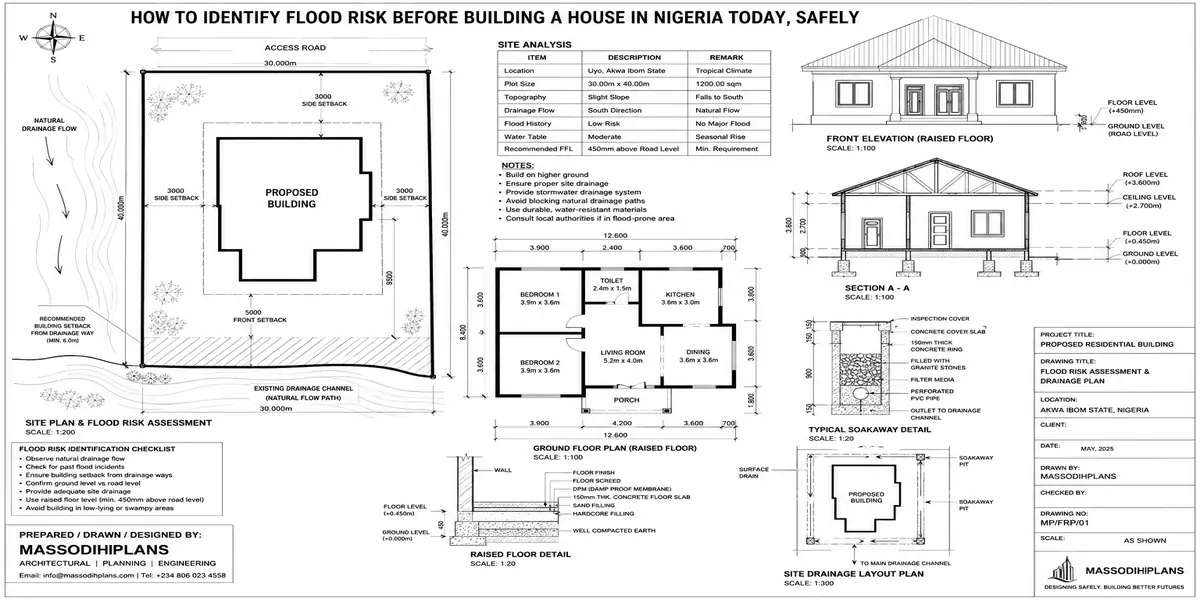
Walk the full perimeter of the plot and its immediate neighbours, and note visually whether the plot sits lower, level, or higher than the street and the plots on either side. A plot sitting in a visible dip, even a shallow one, will collect water that its neighbours shed.
Where the difference isn’t obvious to the eye, a basic level survey (which a surveyor or your architect can arrange quickly and inexpensively) gives you actual figures rather than guesswork.
Pay attention to the direction the street itself slopes. Water moving down a street has to go somewhere, and if your plot sits at the low end of that slope with no drain to intercept it, it will arrive at your gate during heavy rain regardless of how well-built your compound is.
Step 3: Trace Drainage at Three Scales Plot, Street, and Catchment
Most people only check drainage at the plot level, which is the smallest and least informative scale. Proper drainage assessment works outward.
Plot-Level Drainage
Look at how water currently moves across the plot itself in its undeveloped state where it pools, where it flows freely, and where vegetation growth suggests consistently damp ground even outside the rainy season.
Street-Level Drainage
Check whether the street has functioning drainage channels, and critically follow them to see where they actually lead. A drain that empties into another blocked or undersized drain a few hundred metres away will back up during heavy rain regardless of how well the section in front of your plot is built. This is exactly what happened on the site I described at the start of this guide.
Catchment-Level Drainage
This is the scale almost nobody checks, and it’s the one that matters most for genuinely understanding risk. Stand at the highest visible point near the plot and trace, by eye, the rough area of land that slopes toward your site this is your plot’s catchment. The larger and more built-up that catchment area is, the more stormwater volume will eventually funnel toward your plot during heavy rain, especially if that upstream area has been recently developed and paved over without matching drainage upgrades.
Ask specifically whether any construction has happened upstream of the plot in the last two to three years new estates, road paving, or large concrete compounds. New upstream development without matching drainage investment is one of the fastest ways a previously safe plot becomes flood-prone, and it’s information locals rarely think to volunteer unless asked directly.
Step 4: Check Soil Type and Permeability
Soil doesn’t just affect foundation design it directly determines how much rainwater a plot can absorb versus how much runs off or pools on the surface.
Sandy soil drains relatively well but is common in coastal and reclaimed areas where the water table itself sits close to the surface, creating a different flood risk waterlogging from below rather than surface runoff from above.
Clay-heavy soil absorbs water slowly, meaning heavy rainfall sits on the surface far longer before draining, increasing surface flooding risk even on relatively flat, well-positioned land.
Reclaimed or filled land common across expanding areas of Lagos and other coastal cities often has inconsistent compaction and drainage behaviour that differs significantly from the original, undisturbed ground nearby, and deserves particular scrutiny.
A basic soil test, which you’ll need for foundation design anyway, can be read for this purpose too ask your geotechnical engineer or soil testing firm to specifically comment on drainage characteristics and water table depth, not just bearing capacity.
Step 5: Read the Physical Evidence the Land Itself Is Showing You
Land that has experienced flooding, even occasionally, usually shows physical signs if you know where to look and this evidence often survives long after a dry season has erased any visible flooding.
Tide lines or discoloration on boundary walls, fences, or existing structures at a consistent height above ground level
Silt or sediment deposits in low corners of the plot, which indicate where standing water has previously settled and dried
Vegetation patterns reeds, water-loving grasses, or unusually lush patches in specific areas of an otherwise ordinary plot often indicate consistently damp or waterlogged ground
Erosion channels or exposed roots, which indicate the paths water has repeatedly taken across the site
Cracks in nearby existing structures, particularly horizontal cracking near ground level, which can indicate historical ground movement linked to waterlogging
None of these signs alone is conclusive, but two or three appearing together on the same plot is a strong signal worth investigating further before you commit.
Step 6: Check Proximity to Water Bodies and Canals With Real Distance Context
Proximity to water is the flood risk factor everyone already intuitively checks, so the useful addition here isn’t “check if there’s water nearby” it’s understanding that distance alone isn’t the full picture.
Properties near canals, rivers, or the lagoon front face structurally higher flood risk during heavy rainfall, since these waterways often overflow when rainfall is heavy or when drainage is poor. But two plots at an identical distance from the same waterway can have very different risk levels depending on their elevation relative to that waterway’s typical flood level, and whether they sit on the waterway’s natural floodplain versus genuinely elevated ground beside it.
If a plot is within roughly 200–300 metres of a river, canal, or major drainage channel, don’t rely on visual distance alone ask specifically about that waterway’s recorded flood extent in recent years, which local town planning offices or long-term residents can often describe even without formal documentation.
Step 7: Check the Land’s Satellite History, Not Just Its Current Appearance
This is a step almost no flood-risk checklist mentions, and it’s one of the most useful tools now freely available to anyone planning to build.
Historical satellite imagery (available through free tools showing dated imagery over time) lets you look at the exact same plot across multiple past rainy seasons, not just its current dry-season appearance. Look specifically for:
Visible standing water or waterlogged discoloration on the plot or its immediate surroundings during past wet-season imagery
Changes in surrounding land use over time new construction, new paving, or altered drainage patterns upstream of the plot
The plot’s position relative to visible natural drainage lines or low-lying green corridors that don’t show up on a standard survey plan
This won’t replace a physical site visit, but it gives you a multi-year view of the plot’s behaviour that a single dry-season inspection simply cannot.
If satellite history shows visible waterlogging on a plot during multiple past rainy seasons, treat that as a serious finding requiring proper hydrological assessment not something a fence and some sand filling will reliably solve.
Step 8: Confirm the Land Isn’t Inside a Designated Waterway Setback or Flood Plain
Beyond physical risk, there’s a regulatory dimension that catches many builders off guard. Many state master plans and drainage master plans designate specific waterway setbacks, flood plains, and drainage easements where building is restricted or prohibited outright regardless of how the land looks on the ground.
Before purchase, check with the relevant state town planning or physical planning authority whether the specific plot falls within any designated flood plain, waterway setback, or drainage reserve. Land sold with a seemingly clean title can still fall within one of these zones, and building there creates both a genuine physical risk and a real legal exposure including possible future demolition, regardless of how long the structure has stood.
Step 9: For Borderline Sites, Commission a Proper Hydrological and Geotechnical Assessment
If your site assessment turns up mixed signals reasonable elevation but clay-heavy soil, no visible flood evidence but a large upstream catchment, or proximity to water without clear historical flood data don’t rely on visual judgment alone for a significant investment. A proper hydrological assessment (evaluating catchment size, rainfall intensity, and runoff behaviour) combined with a geotechnical soil investigation gives you an evidence-based risk picture rather than an educated guess, and the cost is genuinely small relative to the cost of building on land that turns out to be unsuitable.
If the Land Has Some Flood Risk But You Still Want to Build
Not every flood risk finding means walking away from a plot but it does mean designing for the risk rather than ignoring it.
Raise the building’s floor level above the surrounding ground and any known flood line, using proper engineered fill rather than loose, uncompacted sand
Design a proper site drainage plan before foundation work begins perimeter drains, graded paving that channels water away from the building rather than toward it, and a clear path for stormwater to leave the site
Use permeable paving in compound areas instead of full concrete coverage, to reduce the volume of runoff the site generates in the first place
Choose a foundation type suited to the actual soil and water table conditions a raft foundation on soft, waterlogged ground rather than a standard strip foundation designed for firmer soil
Avoid basements or sunken living spaces entirely on any plot with elevated flood risk findings, regardless of how appealing the design looks on paper
Keep electrical distribution boards and critical services elevated well above any identified flood risk line, as a practical resilience measure even on land judged to be at lower overall risk
Site filling done badly is one of the most common causes of flood-related structural problems I encounter loose, uncompacted fill settles unevenly over time and can actually worsen drainage rather than solve it. If elevation is your mitigation strategy, insist on proper compaction testing, not just visible height.
Your Pre-Purchase Flood Risk Checklist
- Checked the current NIHSA Annual Flood Outlook for the state and LGA
- Walked the plot and compared its elevation visually against the street and neighbouring plots
- Traced street drainage to confirm where it actually leads, not just whether a channel exists
- Assessed the plot’s likely catchment area and any recent upstream development
- Reviewed soil type and water table depth via soil test
- Inspected the plot for physical flood evidence staining, silt deposits, vegetation patterns, erosion
- Checked proximity to water bodies against their known flood extent, not distance alone
- Reviewed historical satellite imagery across multiple past rainy seasons
- Confirmed with the relevant planning authority that the plot isn’t within a designated flood plain or waterway setback
- Commissioned a hydrological/geotechnical assessment for any plot with mixed or borderline findings
Frequently Asked Questions
Is it safe to build on land that has never flooded before?
Not automatically. Upstream development, changing rainfall patterns, and drainage changes can turn previously safe land risky within a few years, which is why elevation, drainage, and catchment checks matter more than flood history alone.
How can I check official flood risk data for my state in Nigeria?
The Nigeria Hydrological Services Agency (NIHSA) publishes an Annual Flood Outlook classifying communities by flood risk level, based on hydrological and rainfall data check the current year’s outlook for your state and LGA before committing to land.
Does distance from a river guarantee safety from flooding?
No. A plot’s elevation relative to a waterway’s typical flood level matters as much as horizontal distance two similarly distant plots can carry very different risk depending on ground elevation and floodplain position.
Can filling a low-lying plot solve its flood risk?
It can help if done correctly with proper engineered, compacted fill and a real drainage plan but poorly compacted fill can settle unevenly and worsen drainage over time, and filling alone doesn’t address a site sitting within a genuine floodplain.
Who should I consult to properly assess flood risk before buying land in Nigeria?
A registered architect, town planner, or geotechnical/hydrological engineer with local site assessment experience ideally involving a physical site visit during or shortly after heavy rainfall, not just a dry-season inspection.
Conclusion
The plot my client nearly built on outside Uyo wasn’t dangerous because of anything visible on a dry afternoon it was dangerous because of how water moved across it during the one hour a week I actually watched it rain. That’s the difference this guide is built around: flood risk is rarely obvious from a single dry-season visit or a clean title document. It shows up in elevation relative to your neighbours, in where a street drain actually leads, in soil that holds water instead of shedding it, and in official data most people never think to check.
Do the checks in this order, be honest about what borderline findings mean, and design for the risk you find rather than hoping it doesn’t apply to you. That’s what separates a home that survives its first heavy rainy season from one that doesn’t.
If you’re assessing a plot and want a second set of eyes before you commit, our Services page outlines how we support clients through site assessment and design. Browse our Plans Library for designs that can be adapted for elevated or drainage-sensitive sites, or visit Plan School to understand the site investigation and approval process before you build. You can also explore more land and site guides on our Homepage.
Related Guides
- Semi-Detached House Plans: Modern Duplex and Bungalow Designs With Shared Walls, Dimensions, Costs and Layout Ideas
- Courtyard House Plans: Beautiful 2–6 Bedroom Designs With Private Outdoor Spaces, Floor Plans and Dimensions
- Contemporary House Plans: Modern 2–6 Bedroom Designs With Open Layouts, Large Windows, Dimensions and Costs
- House Finishing Cost in Nigeria: Complete Breakdown of Tiles, Painting, Ceiling, Doors, Plumbing and Electrical Work
- Foundation Cost Calculator: Estimate House Foundation Cost From Soil Type, Dimensions, Materials and Labour
- Block Quantity Calculator: How to Calculate the Number of Blocks Needed for Any House From Your Floor Plan
- Cement Quantity Calculator for Building: Calculate Bags Needed for Foundation, Blockwork, Slab, Plastering and Screeding
- Self-Contained House Plans: 15 Efficient Designs With Room Dimensions, Floor Plans, Building Costs and Ideas
- 1 Bedroom House Plan: Affordable Self-Contained Floor Plans With Dimensions, Materials, Cost and Space-Saving Ideas
- 6 Bedroom House Plans: Modern Nigerian Floor Plans With Dimensions, Ensuite Rooms, Parking and Cost Estimates
- How to Analyse a Building Site Before Choosing a House Plan in Nigeria
- How to Check a Plot of Land Before Buying It in Nigeria: Complete Guide
- How to Choose the Right Land for Building a House in Nigeria Safely Today
- How Much Does It Cost to Build a House in Nigeria? Full Guide to Materials, Labour, Foundation, Roofing and Finishing
- Roofing Quantity Calculator: Calculate Roofing Sheets, Timber, Nails, Ridge Caps and Accessories From Your House Plan
- Labour Cost to Build a House in Nigeria: Complete Mason, Carpenter, Plumber, Electrician and Finishing Cost Guide
- How to Draw a Neighbourhood Plan (SPAR): Step-by-Step Guide to Roads, Plots, Land Use, Setbacks and Layout Design
- How to Draw a House Layout Plan: 10 Step-by-Step Guide From Plot Dimensions to Rooms, Doors, Windows and Setback
Author
Massodih Okon is a Nigerian built-environment professional with academic and professional experience in urban and regional planning, geography, architectural design, Landscape Design, GIS and land development.
He holds a Master’s degree in Urban and Regional Planning from the University of Uyo and a first degree in Geography and Regional Planning.
Through MassodihPlans, he publishes practical guides on Nigerian house plans, building design, physical planning, site planning, development approval and residential construction. Read the full author profile →