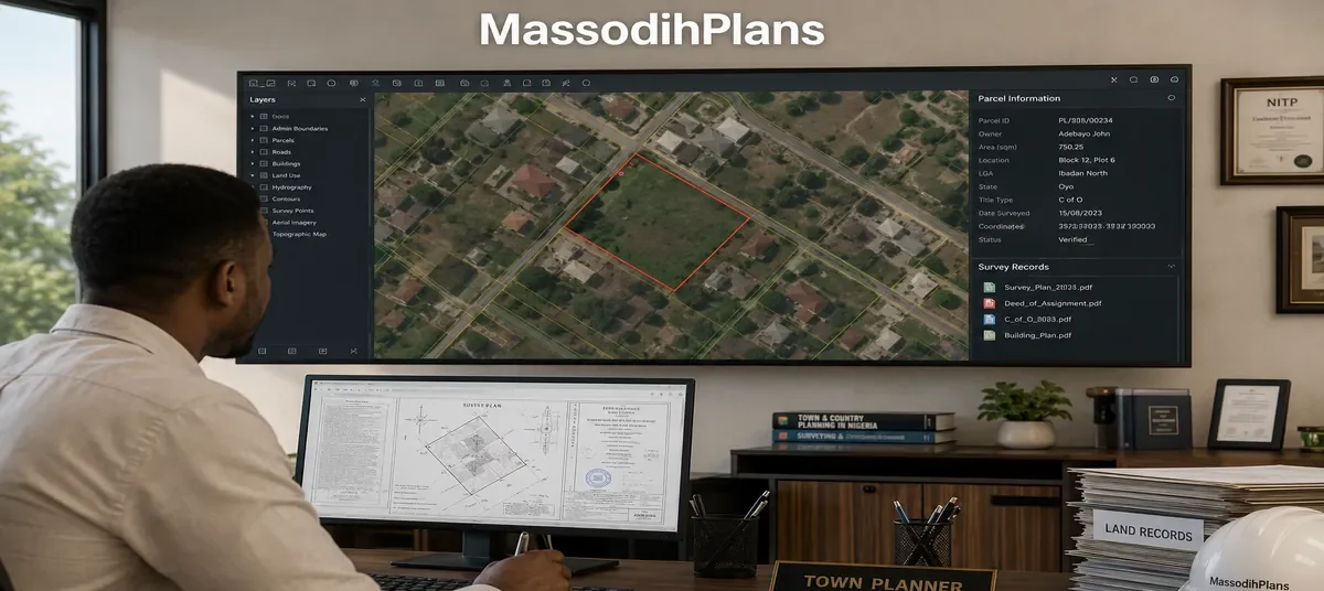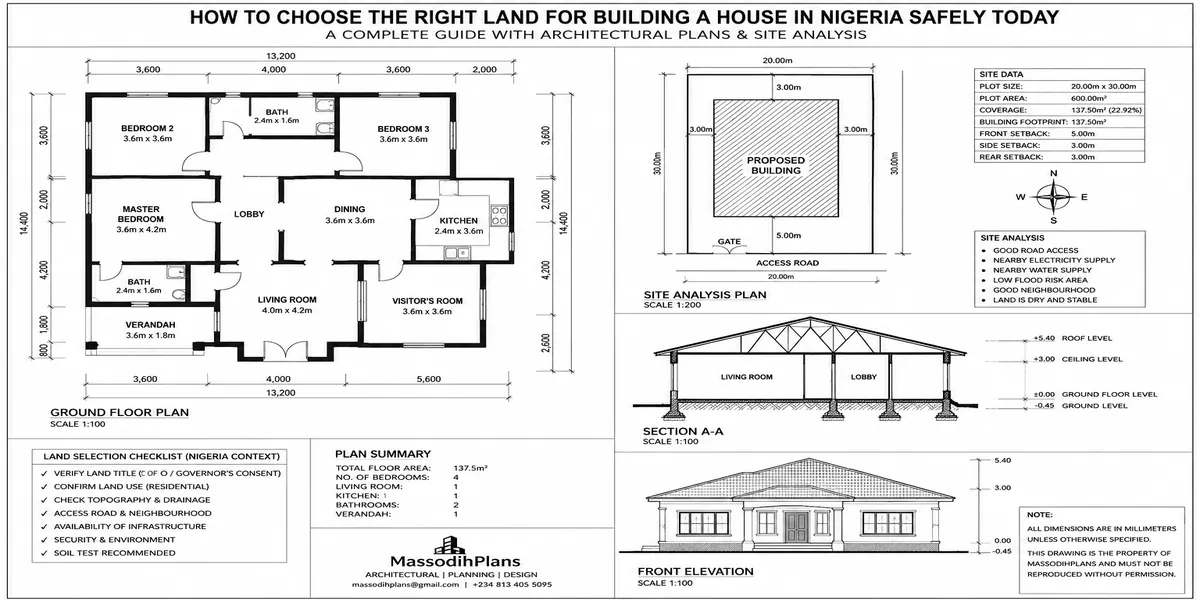
How to Choose the Right Land for Building a House in Nigeria Safely Today
Choosing land in Nigeria is not simply a matter of finding a plot, negotiating a good price, and paying the seller. The wrong land can turn your dream house into years of legal disputes, flooding, unexpected foundation costs, planning problems, or even a building you cannot legally develop.
So, how do you choose the right land for building a house in Nigeria safely today? Start by thinking beyond the land price. You need to know who owns the property, whether the title and survey information are genuine, whether the land is affected by government acquisition or other restrictions, and whether the site matches the documents. A survey and title search are therefore not optional shortcuts; they are part of protecting your investment.
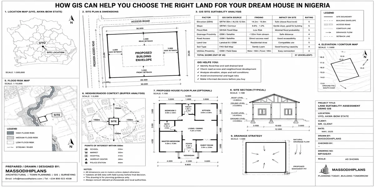
But another mistake many buyers make is inspecting the documents and forgetting to inspect the land itself. Before you commit your money, study the road access, drainage, flood history, slope, soil conditions, surrounding development, electricity, water availability, noise, future roads, and planning requirements that could determine how much of the plot you can build on. Government planning guidance emphasizes site knowledge, orientation, open space, circulation, parking, soil, groundwater, topography, setbacks, and surrounding properties.
In this guide, I will take you beyond the “check the title” advice. I will show you how to examine a Nigerian plot like a planner, surveyor, architect, developer, and buyer working together. You will learn what to check before payment, warning signs that should make you walk away, questions to ask the seller, and how to determine whether your proposed house can realistically fit the site. By the end, you should be able to make a safer land-buying decision with greater confidence.
Why Most Land Vetting Advice Fails People
The generic version of this topic online reads roughly the same everywhere: check the title, check the location, check accessibility, consult a lawyer and surveyor. All true. None of it tells you what to actually look for when you’re standing on the land, what documents genuinely protect you versus which ones are decorative, or how to interpret what you find. Land disputes, structural failures from bad soil, and stalled projects from title problems rarely happen because someone skipped “checking the title” entirely they happen because someone checked it superficially, misunderstood what they were looking at, or trusted a document that looked official but wasn’t.
The protocol below is organized the way real land vetting actually proceeds: documents first, then physical site assessment, then technical/soil verification, then a final risk scoring step most buyers never think to do at all.
Phase 1: Document and Title Verification
This is the phase everyone knows they “should” do. Here’s how to actually do it properly.
Identify What Document You’re Actually Being Sold
Nigerian land titles come in several forms, and they are not interchangeable in the protection they offer:
Certificate of Occupancy (C of O): the strongest individual title document, issued by the state government, confirming statutory right of occupancy
Governor’s Consent: required to validly transfer a C of O-titled property from seller to buyer a C of O alone in the seller’s name, without consent to transfer being processed, is not yet fully secure in your name
Registered Deed of Assignment: a legally registered transfer document, weaker alone than a C of O but far stronger than an unregistered one
Excision/Gazette: confirms that a specific area of land has been formally released from government acquisition back to the original community or family critical in areas with overlapping government acquisition claims
Family/Customary receipt: the weakest form, essentially evidence of a local transaction with no government backing extremely common and extremely risky without further verification
Ask the seller directly which of these they hold, in writing, before you go any further. A seller who becomes evasive or vague about which document they actually have is itself a warning sign.
Conduct an Actual Land Registry Search
This is different from just “having a lawyer look at the papers.” A registry search means physically verifying at the relevant state Land Registry or Bureau of Lands that the title document you’ve been shown is genuine, correctly registered, and not already encumbered, disputed, or sold to someone else. Many buyers skip this step because it costs time and a modest fee, then discover sometimes years later that the “original” document they hold was one of several sold on the same plot.
Check for Government Acquisition
In many Nigerian states, large tracts of land remain under government acquisition even decades after being informally sold off by communities or families. Land under active government acquisition, without a valid excision or gazette releasing it, can be reclaimed by the state at any time regardless of how long you’ve occupied it or how much you’ve built. This single check has prevented more of my clients from catastrophic loss than any other step in this entire process.
Confirm Land Use and Zoning Classification
Beyond the title, confirm what the land is actually zoned for residential, commercial, agricultural, or reserved for future infrastructure like road expansion or drainage. Land can have a perfectly valid title and still be unsuitable or restricted for the specific kind of building you intend, or subject to a setback or use restriction that isn’t obvious from the title document alone.
Never rely solely on a document shown to you by the seller or their agent. Conduct your own independent search at the Land Registry, and where the transaction is significant, commission a professional legal search rather than a verbal assurance that “everything is fine.” This single habit prevents the majority of catastrophic land disputes in Nigeria.
Phase 2: The Physical Site Inspection Protocol
This is where most buyers do the least, despite it being where the most learnable, physical evidence sits. Walk the land using this sequence.
Step 1: Confirm the Boundaries Match the Survey Plan
Bring a copy of the survey plan to the site and physically locate the beacon markers (the small concrete or metal pillars marking plot corners). Confirm the plot’s actual dimensions and shape on the ground match what’s on paper. Missing, shifted, or damaged beacons are common where boundary disputes exist or are brewing, and this is something you can verify yourself in minutes.
Step 2: Read the Topography
Walk the entire plot, not just the frontage. Note whether the land slopes, and in which direction. A plot that slopes away from the road toward a low point in the middle or rear is a flood risk regardless of how dry it looks during a site visit in the dry season water always finds that low point during heavy rain. A gently sloping plot that drains toward the road or a defined drainage channel is generally safer than a flat, bowl-shaped, or low-lying one.
Step 3: Look for Water Evidence, Even in Dry Season
This is the step almost nobody does properly, and it’s the one that prevents the most expensive mistakes. Look for: watermark staining on nearby fences or walls, unusually lush or reed-like vegetation growth (a sign of a consistently wet water table), visible erosion channels, or a noticeably spongy or soft feel underfoot in low-lying sections. If you’re inspecting during dry season which is when most land purchases happen actively ask neighbours and long-term residents nearby what the site looks like in peak rainy season. Their answer is often more reliable than what your eyes tell you in January.
Step 4: Inspect Access Roads in Both Directions
Walk or drive the access route from the nearest major road to the plot, not just the final approach. Note road surface condition, width (can two vehicles pass, or is it single-lane with passing points), and whether the route floods or becomes impassable in rain ask specifically about rainy-season conditions, since a road that looks fine in dry season can become unusable for weeks during heavy rains in many developing Nigerian layouts.
Step 5: Check for Encroachment and Easements
Confirm whether any part of the plot falls within a drainage easement, power line right-of-way, or road reserve land that looks like part of your plot but legally cannot be built on. This is frequently discovered only after construction has started, when it’s far more expensive to resolve. Cross-reference the survey plan against what’s physically marked or fenced on the ground.
Step 6: Assess Immediate Neighbours and Surrounding Land Use
What’s built or being built on the immediately adjacent plots tells you a great deal an active dumpsite, a noisy industrial operation, or an informal settlement encroaching on the boundary are all things a document search will never reveal but a physical visit will.
Visit the same plot at least twice once during a dry period and, if at all possible, once during or immediately after a heavy rain. If you can’t manage that yourself, ask a local artisan, security guard, or long-standing resident nearby what the site looks like after a downpour. This one habit has saved more of my clients from flood-prone land than any document ever could.
Phase 3: Soil and Geotechnical Assessment
This is the phase almost every generic guide skips entirely, or mentions in one vague sentence, despite it directly determining both your safety and your foundation cost.
Why Soil Testing Isn’t Optional
Nigeria’s soil conditions vary dramatically even within the same city from firm lateritic soil that supports a standard strip foundation cheaply, to sandy or reclaimed swamp soil in coastal and low-lying areas (common across much of Lagos, Port Harcourt, and Uyo’s waterside districts) that requires a raft or pile foundation costing several times more. A soil test, conducted by a qualified geotechnical engineer or soil laboratory, tells you the bearing capacity of the ground and the appropriate foundation type before you commit to the land, not after you’ve already paid for it.
What a Soil Test Actually Reveals
Bearing capacity how much load the soil can safely support, which determines foundation type and directly affects construction cost
Water table depth a high water table close to the surface complicates foundation work and increases moisture-related risk to the structure over time
Soil composition whether you’re dealing with stable lateritic soil, loose sandy fill, or expansive clay that shifts significantly with moisture changes
Contamination or fill history some plots, especially in reclaimed or previously industrial areas, contain buried waste, unstable fill material, or contamination that a visual inspection alone cannot detect
When to Commission the Test
Ideally, before you finalize the purchase, not after a soil test costing a modest fee can reveal a foundation cost implication running into millions of naira, or in worse cases, reveal the land is genuinely unsuitable to build on safely at any reasonable cost. Where a full test isn’t feasible before purchase, insist on it immediately after and before any architectural design work proceeds, since foundation design depends entirely on its results.
Never accept a verbal assurance from a seller, agent, or even a builder that “the ground is fine” as a substitute for an actual soil test. This is one of the most consequential and most skipped steps in the entire Nigerian home-building process, and the cost of skipping it is almost always paid later, at a much higher price, during or after construction.
Phase 4: Location and Long-Term Value Factors
Once title, physical condition, and soil have cleared, location factors determine whether the land serves you well over the long term, not just at the point of purchase.
Infrastructure That Actually Exists Today
Distinguish clearly between infrastructure that exists now and infrastructure a developer or agent promises is “coming soon.” Roads, drainage, power connection points, and water access that exist today are verifiable; future promises are not, and should never be a primary factor in your land decision or your budget for accessing the plot.
Growth Trajectory of the Area
Areas with visible active development new roads under construction, increasing housing density, nearby commercial activity tend to appreciate faster than static or declining areas, but growth also brings rising land prices and eventually rising costs to buy in. Balancing early-stage affordability against confirmed present-day infrastructure is the real trade-off, not chasing the cheapest land in an area with no visible development activity at all.
Proximity to Essential Services
Distance to your workplace, schools, healthcare, and markets affects daily life far more than it affects the land purchase decision itself, but it belongs in your evaluation because it determines whether the home you eventually build is one you’ll actually enjoy living in day to day.
Community and Security Context
Speak directly with residents already living in the area, not just the agent selling the land. Ask about communal land disputes, security incidents, and how disagreements with neighbouring communities over land boundaries have historically been handled in that specific area this is information no document will ever contain.
The Land Safety Scorecard
Score each category from 0 (serious concern) to 2 (fully verified and clear) as you complete your vetting. This isn’t a scientific instrument it’s a discipline that forces you to actually complete every step rather than skip the inconvenient ones.
- Title document verified at Land Registry: __ / 2
- Confirmed free of government acquisition (or validly excised): __ / 2
- Boundaries match survey plan on the ground: __ / 2
- No visible or reported flooding/water table issues: __ / 2
- Soil test completed with acceptable bearing capacity: __ / 2
- Access road confirmed usable in both dry and rainy season: __ / 2
- No encroachment on drainage easements or road reserves: __ / 2
- Zoning/land use confirmed suitable for intended building: __ / 2
A total below 12 out of 16 means real, unresolved risk remains don’t proceed to purchase until the specific low-scoring items are properly investigated and resolved, no matter how attractive the price or how much pressure you feel to close the deal quickly.
Sellers and agents routinely create urgency “another buyer is interested,” “the price goes up next week.” Genuine land with clean title and safe soil conditions will still be genuine next week. Urgency pressure is one of the most reliable signs that a deal deserves more scrutiny, not less.
Red Flags That Should Stop You Immediately
The seller cannot produce an original title document, only a photocopy, and becomes evasive when asked for the original
The land is significantly cheaper than comparable plots nearby with no clear explanation
Multiple different people claim to represent the same seller or family
The survey plan’s coordinates or dimensions don’t match what’s physically marked on the ground
Neighbours or long-term residents report an active or recent boundary or ownership dispute over the specific plot
The agent actively discourages an independent Land Registry search or soil test, or claims it’s “unnecessary” or “already done, trust me”
Frequently Asked Questions
What is the single most important thing to check before buying land in Nigeria?
Title verification at the Land Registry and confirmation the land is free of unresolved government acquisition this single check prevents the most catastrophic and irreversible category of loss, more than any other factor.
Is a soil test really necessary before buying land, not just before building?
Ideally yes. A soil test before purchase can reveal that a plot needs a foundation type costing significantly more than standard, or in some cases that the land isn’t safely buildable at a reasonable cost at all information that should factor directly into your purchase decision, not just your construction budget afterward.
How can I tell if land is flood-prone if I’m inspecting during dry season?
Look for watermark staining, unusually lush low-lying vegetation, and soft or spongy ground in low points, and directly ask neighbours or long-term residents what the site looks like during heavy rain their answer is often the most reliable indicator available outside of an actual rainy-season visit.
Can land with a Certificate of Occupancy still be risky?
Yes, if the transfer to you hasn’t been properly processed through Governor’s Consent, if the C of O itself was fraudulently obtained, or if the physical boundaries and soil conditions weren’t separately verified a valid title document addresses ownership risk, not physical site risk.
Should I use an agent or go directly to a landowning family?
Either path can work, but the safety comes from your own independent verification process, not from who introduced you to the land. A reputable agent adds convenience and local knowledge; it does not replace your own Land Registry search and site inspection.
Conclusion
Choosing the right land safely in Nigeria isn’t about following a list of buzzwords it’s about running an actual verification sequence: documents first, physical site evidence second, technical soil assessment third, and an honest scoring of what you’ve genuinely confirmed versus what you’re hoping is fine. Land that passes all four phases costs you time and modest verification fees upfront. Land that fails silently through any one of them can cost you the entire investment, years later, at the worst possible moment.
Once your land clears this process, our Services page outlines how we support clients from site assessment through to design and approval. Browse our Plans Library for house designs suited to different soil and plot conditions, or visit Plan School to understand how soil test results and site conditions shape your eventual building plan. You can also explore more land and building guides on our Homepage.
Related Guides
- How Much Does It Cost to Build a House in Nigeria? Full Guide to Materials, Labour, Foundation, Roofing and Finishing
- Roofing Quantity Calculator: Calculate Roofing Sheets, Timber, Nails, Ridge Caps and Accessories From Your House Plan
- Labour Cost to Build a House in Nigeria: Complete Mason, Carpenter, Plumber, Electrician and Finishing Cost Guide
- How to Draw a Neighbourhood Plan (SPAR): Step-by-Step Guide to Roads, Plots, Land Use, Setbacks and Layout Design
- How to Draw a House Layout Plan: 10 Step-by-Step Guide From Plot Dimensions to Rooms, Doors, Windows and Setback
- Semi-Detached House Plans: Modern Duplex and Bungalow Designs With Shared Walls, Dimensions, Costs and Layout Ideas
- Courtyard House Plans: Beautiful 2–6 Bedroom Designs With Private Outdoor Spaces, Floor Plans and Dimensions
- Contemporary House Plans: Modern 2–6 Bedroom Designs With Open Layouts, Large Windows, Dimensions and Costs
- House Finishing Cost in Nigeria: Complete Breakdown of Tiles, Painting, Ceiling, Doors, Plumbing and Electrical Work
- Foundation Cost Calculator: Estimate House Foundation Cost From Soil Type, Dimensions, Materials and Labour
- Block Quantity Calculator: How to Calculate the Number of Blocks Needed for Any House From Your Floor Plan
- Cement Quantity Calculator for Building: Calculate Bags Needed for Foundation, Blockwork, Slab, Plastering and Screeding
- Self-Contained House Plans: 15 Efficient Designs With Room Dimensions, Floor Plans, Building Costs and Ideas
- 1 Bedroom House Plan: Affordable Self-Contained Floor Plans With Dimensions, Materials, Cost and Space-Saving Ideas
- 6 Bedroom House Plans: Modern Nigerian Floor Plans With Dimensions, Ensuite Rooms, Parking and Cost Estimates
Author
Massodih Okon is a Nigerian built-environment professional with academic and professional experience in urban and regional planning, geography, architectural design, Landscape Design, GIS and land development.
He holds a Master’s degree in Urban and Regional Planning from the University of Uyo and a first degree in Geography and Regional Planning.
Through MassodihPlans, he publishes practical guides on Nigerian house plans, building design, physical planning, site planning, development approval and residential construction. Read the full author profile →