Why Towns Fail Without a Master Plan (And Exactly How to Build One Right)
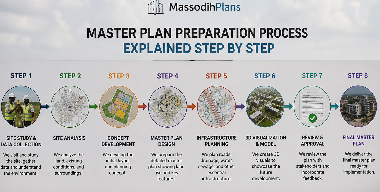
Master Plan Preparation Process Explained Step by Step
If you have ever wondered why some towns in Nigeria grow in an orderly and livable way while others turn into a cluster of overcrowded streets, choked drainages, and buildings sitting on each other’s setbacks, the answer is almost always one thing: the presence or absence of a master plan. A master plan is the document that guides how a settlement grows, what goes where, how roads connect, where water flows, and how people will live ten, twenty, or thirty years from today. Without it, even a promising community will eventually collapse under the weight of its own disorder.
The master plan preparation process is the structured set of steps that professional town planners follow to produce that guiding document. It is not just about drawing maps. It involves studying the land, understanding the people, projecting future needs, designing land use zones, planning roads and drainage, and integrating all of this into a realistic and legally defensible document.
In my experience as a registered Town Planner and Architectural Designer, many people including developers, local government officials, estate promoters, and even some engineers, approach master plan preparation without fully understanding the steps involved. This article is my direct attempt to change that. I am going to walk you through the entire process, step by step, the way I would explain it to a student in my studio or a client sitting in my office in Uyo.
Quick Answer
The master plan preparation process includes: base map production, data collection, situation analysis, problem identification, goal setting, land use planning, road and infrastructure design, zoning, phasing, stakeholder engagement, and formal approval. Each step builds on the last and all must be completed for the plan to work.
Before I go into the steps, let me show you why getting this process right matters urgently for Nigeria and for the rest of the world.
Why the Master Plan Preparation Process Matters More Than Most People Realise
This is not just theory. I have seen it happen. I have worked with clients who purchased plots in communities that had no approved master plan, only to discover later that their land sat in what was supposed to be a road reserve or a drainage corridor. The heartbreak on their faces stays with me.
When a settlement grows without a master plan, the consequences are predictable and painful:
- Buildings go up everywhere without setbacks, blocking light, airflow, emergency access, and future road expansion
- Roads become too narrow to carry the traffic load, triggering daily gridlock
- Markets invade residential areas, creating noise, waste, and incompatible land use conflicts
- Drainage channels get blocked, buildings sit on floodplains, and every rainy season brings destruction
- Slums form where there should be decent housing
- Public facilities like schools, health centres, and parks never get built because no land was reserved for them
- Industries end up beside homes, exposing families to pollution and health hazards
- Security agencies cannot reach emergencies because streets are inaccessible
- Government loses revenue because land cannot be properly administered or taxed
- Investors avoid the area because the environment looks chaotic and risky
These are not abstract problems. They describe Aba, parts of Onitsha, sections of Lagos Island, and dozens of smaller Nigerian towns. They also describe cities in parts of West Africa, South Asia, and Latin America that grew fast but without planning discipline. A well-prepared master plan prevents all of this from the very beginning.
From the Field
During a project I worked on in Akwa Ibom State, we were called to advise on a developing community that had already attracted significant residential investment. When we conducted our base map analysis, we discovered that almost 30 percent of the built-up area was sitting on land that should have been a stormwater corridor. The cost of correction was enormous. It could have been avoided entirely with a master plan prepared before development began.
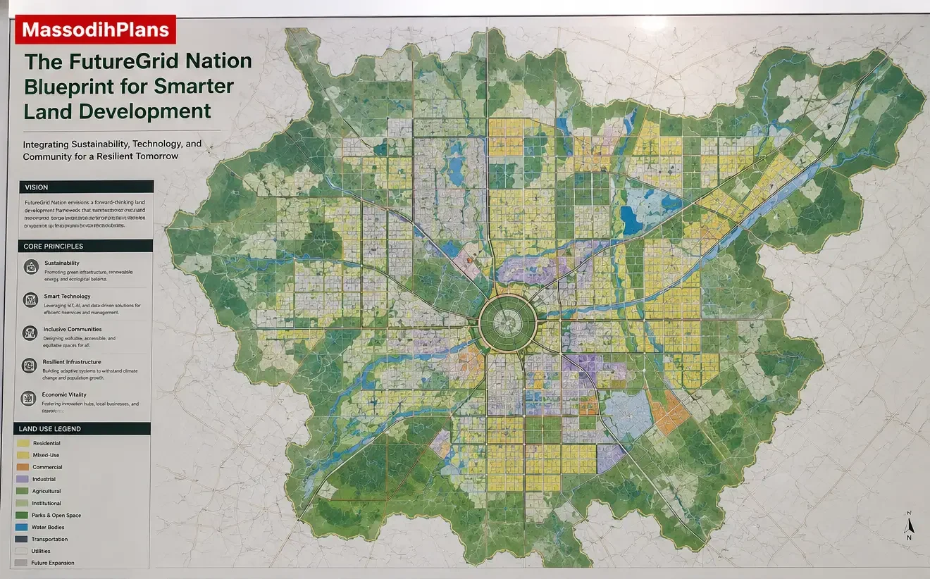
What Is a Master Plan and What Does It Contain?
I first learned this concept while studying Town Planning at the University of Uyo. Our lecturers constantly emphasized that a master plan is a long-range physical development plan that provides a comprehensive framework for how land in a defined area should be used, developed, and managed over a planning horizon of typically fifteen to thirty years.
A standard master plan document contains:
- An existing land use map showing the current state of the area
- A proposed land use plan showing how each parcel of land is zoned for future use
- A road and circulation plan showing road hierarchy from primary to local streets
- An infrastructure plan covering water supply, drainage, electricity, and sewerage
- A green and open space plan showing parks, buffers, and environmental corridors
- A phasing plan showing what gets developed in which order
- A development control framework setting out regulations, setbacks, plot ratios, and permitted uses
- A population projection showing expected growth over the planning horizon
- An implementation strategy connecting the plan to budgets, agencies, and timelines
Now, let me walk you through the step-by-step process that produces this document.
Step 1: Define the Planning Area and Establish the Brief
Every master plan starts with clarity about what area is being planned and what the plan is supposed to achieve. This sounds obvious but it is where many poorly structured planning exercises go wrong from the beginning.
During my internship, I observed that projects that began without a clearly defined planning brief often ended up producing documents that satisfied nobody, including the commissioning authority. A good brief answers:
- What is the geographic boundary of the planning area?
- Who is commissioning the plan and who will implement it?
- What is the planning horizon, meaning how many years ahead is the plan designed for?
- What are the key problems the plan must solve?
- What budget and resources are available for preparation and implementation?
- Are there existing plans that this master plan must relate to or supersede?
The planning brief is usually prepared by the commissioning agency, whether a Local Government Authority, State Ministry of Lands and Housing, a private estate developer, or a development authority. The town planner reviews, refines, and sometimes helps prepare the brief before any field work begins.
Expert Note: If you are a developer commissioning a master plan for a large estate, insist on preparing a written brief before work begins. It protects both you and the planner by making expectations explicit from day one. This is the approach I would personally take and I recommend it to every client.
Step 2: Collect and Compile Base Data
You cannot plan for a place you do not understand. Base data collection is the intelligence-gathering phase of master plan preparation and it covers two categories: spatial data and socio-economic data.
Spatial Data Collection
- Topographic maps of the planning area
- Satellite imagery and aerial photographs
- Survey data including boundary coordinates, contours, and land ownership records
- Existing infrastructure mapping, showing roads, utilities, and drainage
- Soil type and geology data relevant to construction suitability
- Hydrological data including rivers, streams, floodplains, and wetlands
- Vegetation and environmental data
- Land ownership and title documentation
Socio-Economic Data Collection
- Population census data and growth trends
- Household income levels and economic activities
- Employment patterns and major employers in the area
- Cultural patterns and land tenure systems, especially important in southern Nigeria where family land is common
- Existing community facilities, schools, health centres, markets, and places of worship
- Traffic counts and movement patterns
- Public opinion and community priorities through structured stakeholder interviews
My academic training exposed me to the reality that data collection in Nigeria often runs into challenges: outdated census figures, missing cadastral records, informal land arrangements, and communities suspicious of government-linked surveys. Good planners build these realities into their data collection strategy from the start.
Step 3: Produce the Base Map Using GIS and Mapping Tools
Based on projects I have worked on, the base map is arguably the most important single output in the entire master plan process. It is the spatial foundation on which every subsequent decision is plotted and tested. A weak base map leads to planning decisions that do not reflect reality on the ground.
The base map is produced using Geographic Information Systems, or GIS, combined with survey data, satellite imagery, and field verification. It typically shows:
- The exact boundary of the planning area
- Existing land uses, what is currently on each piece of land
- Road networks, both formal and informal
- Water bodies, drainage channels, and flood-prone zones
- Vegetation cover and open spaces
- Infrastructure including electricity lines, water mains, and sewer systems
- Topographic contours showing slopes and drainage directions
- Built structures classified by type
In modern master plan preparation, GIS tools like ArcGIS, QGIS, and AutoCAD Civil 3D are used to produce these maps with precision. Drone surveys are increasingly used in Nigeria to capture detailed imagery where satellite resolution is insufficient.
Nigerian Reality Layer: In many parts of Nigeria, formal cadastral maps either do not exist or are decades out of date. In practice, experienced planners combine whatever official data exists with field GPS surveys, drone imagery, and community-provided information to build a workable base map. This observation comes from practical field experience working in states including Akwa Ibom and Rivers.
Step 4: Analyse the Existing Situation
With data collected and the base map produced, the next step is analysis. This is where the planner studies what exists, understands what is working, identifies what is failing, and draws conclusions that will shape the plan.
Key analyses performed at this stage include:
Land Use Analysis
- What land uses currently exist and where are they located?
- Are the current uses appropriate for their locations?
- Are there land use conflicts, such as industries beside homes or markets in residential streets?
- How much of the land is developed, undeveloped, or under-utilised?
Population and Demographic Analysis
- Current population of the planning area
- Population growth rate based on census trends
- Age structure and household size, which affects housing demand
- Migration patterns, whether people are moving into or out of the area
- Projected population for the planning horizon using demographic models
Infrastructure Capacity Analysis
- Are existing roads wide enough to handle current and future traffic?
- Is water supply reaching all parts of the community?
- Are drainage systems functional and adequate?
- Is electricity distribution planned and reliable?
- Are there sewage systems or is the area relying entirely on septic tanks?
Environmental Analysis
- Where are the flood-prone zones that must not be built upon?
- Where are the steep slopes that require special foundation treatment?
- Where are the wetlands, forests, and green corridors that need protection?
- What are the main sources of pollution in the area?
This conclusion is based on both academic training and real-world observation: the quality of the situation analysis phase determines the quality of the entire master plan. A plan based on poor analysis will fail in implementation regardless of how beautifully drawn it is.
Step 5: Identify Problems, Set Goals, and Define Planning Objectives
After analysis, the planner prepares a clear problem statement that summarises the key challenges the master plan must address. From these problems, planning goals and objectives are derived.
For example, if the situation analysis shows that the area has poor road connectivity and frequent flooding, the goals might be:
- To create a well-connected, hierarchical road network that serves all parts of the planning area
- To protect natural drainage corridors and design adequate stormwater infrastructure
- To prevent development in flood-prone zones through zoning regulations
Each goal is then broken down into specific, measurable objectives that will guide the physical design decisions in the next phase. This is the bridge between diagnosis and prescription.
Expert Note: One lesson I learned early is that goals set without community input are often resisted during implementation. The best master plans involve the community in identifying problems and validating goals before the physical design begins. This is not just best practice, it is political and social intelligence.
Step 6: Prepare the Land Use Plan
The land use plan is the heart of the master plan. It assigns specific use categories to every piece of land within the planning area, creating a spatial blueprint for what goes where.
Understanding Land Use Categories
Standard land use categories used in Nigerian and international town planning include:
- Residential Low Density: Large plots for single-family homes with generous setbacks and open space
- Residential Medium Density: Smaller plots allowing flats and semi-detached houses
- Residential High Density: Compact plots for apartment blocks and mixed tenancy
- Commercial: Shops, offices, markets, and business premises
- Industrial: Light, medium, and heavy manufacturing uses, always separated from residential areas by buffer zones
- Institutional: Government offices, schools, hospitals, police stations, courts, and similar public facilities
- Recreational: Parks, playgrounds, sports facilities, and green belts
- Agricultural: Farming land, orchards, and agro-processing areas
- Open and Green Space: Environmental buffers, flood corridors, wetlands, and urban forests
- Special Purpose: Cemeteries, utility installations, and infrastructure corridors
How Land Use Distribution Is Determined
In one housing layout project I worked on, the client initially wanted to allocate nearly 70 percent of the area to residential use to maximise plot sales. My advice was different. A well-functioning community needs a balanced land use distribution. A typical master plan distributes land roughly as follows:
| Land Use Category | Typical Range | Why It Matters |
| Residential (all densities) | 40 – 50% | Core living areas for the population |
| Roads and Circulation | 15 – 25% | Movement network for people, vehicles, and utilities |
| Open and Green Spaces | 10 – 15% | Environmental health, recreation, drainage corridors |
| Commercial and Markets | 5 – 10% | Economic activity and daily trade |
| Institutional Facilities | 5 – 8% | Schools, health centres, government buildings |
| Industrial / Light Industry | 3 – 8% | Employment and production zones |
| Special Purpose / Utilities | 2 – 5% | Power stations, water treatment, waste sites |
From a planning perspective, I strongly recommend that no master plan allocate less than ten percent to open and green spaces. This is not a luxury. It is a public health, environmental, and climate resilience requirement.
Step 7: Design the Zoning Framework
At the University of Uyo, we were taught that zoning is the legal instrument through which land use plans are enforced. Zoning assigns specific regulations to each land use zone, controlling what can be built, how big it can be, how far it must sit from the boundary, and what activities are permitted.
Standard Zoning Regulations Include:
- Permitted uses: What types of buildings or activities are allowed in each zone
- Conditional uses: Uses that may be allowed subject to special approval, such as a church in a residential zone
- Prohibited uses: Uses that are not allowed under any circumstances in that zone
- Plot size minimum: The smallest plot that is permissible in each zone
- Setbacks: The minimum distance buildings must maintain from the plot boundaries
- Plot coverage ratio: The maximum percentage of the plot that can be built upon
- Floor area ratio: The ratio of total floor area to plot area, controlling building density
- Building height limits: Maximum allowable heights to control density and character
- Car parking standards: Minimum parking spaces required per type of development
Setbacks Explained Simply
If you have ever wondered why your architect tells you that your building cannot sit on the boundary of your plot, this is why. Setbacks are the minimum distances that physical planning regulations require between a building and each plot boundary.
Standard setbacks in Nigerian master plan regulations typically look like this:
- Front setback: 3 to 6 metres from the road reserve boundary
- Rear setback: 3 metres minimum from the back boundary
- Side setbacks: 1.5 to 3 metres on each side of the building
These distances provide space for landscaping, ventilation, emergency access, future road widening, and the visual character of the street. Buildings that violate setbacks not only expose owners to demolition orders but also undermine the entire community’s quality of life.
Step 8: Plan the Road and Circulation System
One of the most visible failures of unplanned settlements is the road network. Streets that were never designed for vehicular traffic, roads that end without connecting anywhere, and lanes too narrow for two cars to pass each other. All of this is avoidable when the master plan gets road design right.
Road Hierarchy in Master Plan Design
A well-designed road network uses a hierarchical structure that separates different types of movement:
| Road Type | Reserve Width | Carriageway | Function |
| Primary Arterial Road | 50 – 60m | 21 – 30m | Main spine connecting zones and external routes |
| Secondary Collector Road | 25 – 40m | 14 – 21m | Connects neighbourhoods to the arterial network |
| Residential Access Road | 15 – 20m | 7 – 10m | Serves individual plots in residential areas |
| Service Lane / Cul-de-sac | 9 – 12m | 6 – 7m | Short access ways to small groups of plots |
Pedestrian and Non-Motorised Facilities
Many Nigerian master plans historically ignored pedestrians. Modern master plans, particularly those responding to climate change and public health priorities, include:
- Sidewalks along all collector and arterial roads
- Pedestrian crossings at junctions
- Dedicated cycle lanes where population density warrants
- Accessible pathways for people with disabilities
- Shade trees along major pedestrian routes
Parking Standards
Plot-based parking requirements are embedded in the zoning framework and must be reflected in all site development plans:
- Residential plots: Minimum 2 car spaces per dwelling unit for medium and high-income housing
- Commercial developments: 1 space per 30 square metres of retail floor area
- Office buildings: 1 space per 40 square metres of office floor area
- Industrial premises: 1 space per 500 square metres of floor area, plus truck parking
Step 9: Plan Plot Arrangements Within Neighbourhoods
During studio exercises at university, we spent weeks learning how to arrange plots within neighbourhood blocks. This might seem like a detail but it determines whether a community is livable or chaotic at the street level.
Good plot arrangement considers:
- Plot orientation to maximise natural ventilation and daylight in the Nigerian climate
- Plot depth and frontage ratios that allow functional building layouts
- Corner plots that get additional setback requirements to maintain street sightlines
- Super-blocks that reduce through-traffic in residential areas
- Cul-de-sac arrangements that create safer, quieter residential enclaves
- Perimeter block arrangements that provide internal green courtyards
This principle formed a major part of our coursework: in hot humid climates like southern Nigeria, plots should ideally be oriented with their longer axis running east-west so that buildings can use the prevailing south-west breeze effectively. This reduces the need for mechanical cooling and lowers building operating costs.
Step 10: Design the Infrastructure and Utilities Plan
A master plan that does not plan for infrastructure is not a master plan. It is just a pretty drawing. Infrastructure planning covers five critical systems:
Water Supply
- Location of water treatment plants or borehole fields
- Distribution network design showing primary and secondary water mains
- Storage tank locations based on terrain and pressure requirements
- Coverage standards to ensure every plot has access to water
Stormwater Drainage
Based on projects I have worked on, drainage is the infrastructure system most frequently neglected in Nigerian urban development and the one that causes the most damage when it fails. The master plan must include:
- A primary drainage network following natural valley lines
- Secondary drains along all road carriageways
- Tertiary plot-level drainage connecting to the secondary network
- Retention ponds or infiltration areas to manage peak stormwater flows
- Strict development control prohibiting buildings in drainage corridors
Electricity Distribution
- Locations for primary substations and distribution transformers
- Underground cable routes along road reserves
- Street lighting design along all public roads
- Coordination with power utility companies on connection capacity
Sewage and Sanitation
- In areas with reticulated sewerage, the plan shows the sewer network aligned with road reserves
- In areas without sewerage, the plan specifies minimum plot size to accommodate septic tanks with adequate separation from water sources
- Public convenience blocks in markets and commercial areas
- Solid waste collection points and transfer station locations
Telecommunications
- Fibre optic route planning along primary and secondary roads
- Mast locations for cellular infrastructure
- Ducting provisions in new road construction to enable future cable installation
Step 11: Plan Environmental Management and Open Spaces
Over the years, I have noticed that the sections of Nigerian towns that maintain the highest quality of life and property values are those that preserved their green spaces during planning. Trees, parks, and environmental corridors are not decorations. They are functional infrastructure.
The environmental management component of a master plan covers:
- Identification and legal protection of flood corridors and riparian buffers
- Designation of urban forests and green belts as development-free zones
- Neighbourhood park distribution, ideally with a park within 500 metres of every residential plot
- Roadside tree planting programmes integrated into road reserve design
- Air quality buffers between industrial areas and residential zones
- Noise barriers along major transportation corridors
- Wetland protection and restoration where development has encroached
- Climate change adaptation measures including permeable surfaces and urban heat island reduction strategies
Human Lifestyle: When I walk through communities in Uyo that were developed with proper open space planning, I notice that children play outdoors, neighbours interact, and people are generally healthier and happier. When I walk through communities where every inch was sold as a plot, I see anxiety, noise, heat, and social isolation. Open spaces are not optional extras. They are what makes a settlement a community.
Step 12: Prepare the Population Projection and Growth Management Strategy
Every decision in a master plan is ultimately shaped by the answer to one question: how many people will be living and working here in fifteen or thirty years? Population projection is the analytical foundation for almost every planning standard applied in the plan.
Methods Used for Population Projection
- Arithmetic progression: Simple addition of average annual growth, suitable for slow-growth areas
- Geometric progression: Compound growth modelling, suitable for rapidly urbanising areas
- Cohort-survival method: Uses age-specific birth and death rates for more complex projections
- Comparative analysis: Compares the area with similar settlements that are further along in development
I did not learn this from a textbook alone. On a project in a rapidly growing peri-urban area of Akwa Ibom, we found that the official census-based projection significantly underestimated actual growth because it did not account for the rapid migration driven by oil sector employment. We had to adjust the projection methodology to reflect this local reality.
Once the population projection is established, it drives:
- How many residential plots of each type are needed
- How many schools, health centres, and community halls must be provided
- What size of water treatment plant, power substation, and drainage infrastructure is required
- How wide the road network needs to be to handle future traffic volumes
Step 13: Plan for Mixed-Use Integration and Urban Functionality
The reality on the ground is often different from what rigid single-use zoning produces. Life is not entirely separated by land use category. People need to buy food near their homes, find work within accessible distance, and access services without long car journeys.
Modern master plans incorporate mixed-use integration through:
- Neighbourhood commercial nodes: Small clusters of shops and services within walking distance of residential areas
- Live-work units: Premises designed to accommodate both dwelling and small business operations
- Transit-oriented development corridors: Higher density mixed-use zones along major public transport routes
- Market and bazaar zones: Formally planned markets located at strategic points in the road network, not allowed to develop informally
- Home occupation permissions: Allowing small professional offices and craft activities within residential zones, subject to conditions
Step 14: Conduct Stakeholder Engagement
A master plan prepared entirely behind closed doors, without involving the people who will live under it, is a plan waiting to fail. Stakeholder engagement is a formal requirement in most planning legislation and a practical necessity for any plan that hopes to be implemented.
Effective stakeholder engagement in master plan preparation includes:
- Community town hall meetings where residents review and comment on draft plans
- Focused consultations with specific groups such as market traders, religious institutions, transport operators, and women’s associations
- Engagement with traditional rulers and community leaders whose authority shapes land acceptance
- Consultations with line agencies including the Ministry of Works, Power, Environment, and Health
- Engagement with private sector investors and developers who will implement portions of the plan
- Formal public exhibitions where draft maps and reports are displayed for public review
Expert Note: I have worked with clients who wanted to skip community engagement to save time and money. I always give the same advice: if you skip engagement, you will lose far more time later when community members resist implementation, dispute boundaries, or refuse to vacate land reserved for public use. In one project, early community engagement uncovered a sacred grove that the planning team had mistakenly identified as an industrial buffer. We corrected the error immediately and prevented a serious cultural conflict.
Step 15: Prepare the Draft Master Plan Document
All the work done in the previous steps comes together in the draft master plan document. This is a comprehensive technical document that includes:
- Executive summary: A concise overview of the plan’s vision, key decisions, and major proposals
- Situation analysis report: Full findings from the data collection and analysis phases
- Planning goals and objectives: The framework that guided all design decisions
- Proposed land use plan with maps: The spatial blueprint for the area
- Zoning regulations: The legal text governing what can be built where
- Road and infrastructure plans: Engineering-level design of major networks
- Environmental management plan: Policies for protecting and enhancing the natural environment
- Development control framework: Standards for plot subdivision, building construction, and land use change
- Implementation strategy: How the plan will be funded, managed, and monitored
- Phasing plan: A staged timeline for development over the planning horizon
Step 16: Plan the Phasing and Implementation Strategy
A master plan without a realistic implementation strategy is a wish list. The phasing plan translates the overall vision into practical stages that match available funding, infrastructure readiness, and market demand.
Typical Phasing Structure
Most master plans for new developments are phased over three stages:
| Phase | Typical Timeline | Key Focus Areas |
| Phase 1: Foundation | Years 1 to 5 | Primary roads, water supply, drainage, electricity, core residential plots, essential public facilities |
| Phase 2: Growth | Years 6 to 15 | Secondary roads, commercial nodes, schools and health centres, secondary residential areas, green spaces |
| Phase 3: Consolidation | Years 16 to 30 | Final road connections, full utility coverage, community facilities, mixed-use areas, urban greening |
Step 17: Obtain Regulatory Approval
While assisting with development control activities during my internship, I learned that even the most technically perfect master plan has no legal force until it passes through the formal approval process. In Nigeria, this involves a structured review by multiple agencies.
The Approval Process for Master Plans in Nigeria
- Submission to the State Ministry of Urban Development, Lands and Housing
- Technical review by the State Urban and Regional Planning Authority
- Environmental impact assessment review by the State Ministry of Environment
- Inter-agency consultations involving Works, Water Resources, and Power ministries
- Public notice and exhibition period allowing objections from the public
- Consideration and resolution of objections by the planning authority
- Endorsement by the Commissioner or Minister responsible for urban planning
- Gazetting of the master plan as a legal document
This is not a fast process. In my experience, the approval of a comprehensive master plan in Nigeria can take between twelve and thirty-six months from submission to gazetting, depending on the complexity of the plan, the level of inter-agency disagreement, and the political context.
Investment Layer: Many developers underestimate the value of having an approved master plan for their estate. An approved master plan is a legal document that protects your investment, enables you to subdivide and sell plots legally, gives purchasers confidence in the legitimacy of their titles, and makes it possible to attract institutional investors and mortgage finance. Having seen the consequences of developing without approval, I advise every serious estate developer to budget for master plan preparation from the very beginning of their project.
Step 18: Implement Development Control
After approving and gazetting the master plan, the planning authority must implement a development control system and enforce the plan on a day-to-day basis. Development control is what prevents the master plan from becoming irrelevant the moment construction starts.
Development control mechanisms include:
- Statutory requirement for development permits before any construction begins
- Site inspection at key stages of construction to verify compliance with approved plans
- Stop-work orders issued for developments that violate the master plan
- Demolition orders for illegal structures
- Penalties and prosecutions for violations
- Regular master plan reviews, typically every five to ten years, to update the plan based on how development has progressed
Experience has taught me that even the best master plan will fail if development control is weak or corrupt. A plan that sits only on paper while developers put buildings in the wrong places does more harm than having no plan at all because it gives people the false impression that planners are addressing the issues while problems continue to grow.
Smart Growth, Climate Responsiveness, and Future Expansion
Modern master plan preparation must go beyond the physical arrangement of land uses and roads. The challenges of climate change, rapid urbanisation, and digital connectivity require master plans to incorporate smart growth concepts.
Smart Growth Principles Relevant to Nigerian Master Plans
- Mixed land use to reduce vehicle trips and increase community vitality
- Compact development to use land efficiently and extend infrastructure cost-effectively
- Walkable neighbourhoods with pedestrian-friendly streets and accessible services
- Transit-oriented development concentrating density around public transport nodes
- Green infrastructure integrating natural systems into the urban environment
- Community diversity allowing housing of different types and prices in the same neighbourhood
- Preservation of open space, farmland, and environmental corridors
Climate Responsiveness
- Orientation of roads and buildings to allow cross-ventilation in the hot humid climate of southern Nigeria
- Flood risk mapping incorporated into land use decisions from the earliest stages
- Urban tree canopy targets built into road reserve and open space standards
- Permeable surface requirements for parking areas and open spaces to reduce run-off
- Setback requirements along riverbanks and coastlines to protect from flooding and erosion
Future Expansion Opportunities
Good master plans always reserve land for future expansion. This means:
- Defining clear urban growth boundaries beyond which development is controlled
- Reserving expansion corridors along major road routes for future urban extensions
- Zoning peripheral land as agricultural or green space until it is needed for urbanisation
- Planning major infrastructure, especially roads and drainage, with capacity for future loads
Common Mistakes in Master Plan Preparation and How to Avoid Them
I have seen this mistake repeatedly: many master plans produced in Nigeria fail not because the planners lacked knowledge but because corners were cut in the process. Here are the most common mistakes and what they cost:
- Skipping community engagement: Creates resistance and boundary disputes that delay implementation for years
- Using outdated base maps: Produces a plan that does not reflect actual conditions on the ground
- Ignoring drainage corridors: Leads to flooding that destroys roads and properties every rainy season
- Underestimating population growth: Results in infrastructure that is overwhelmed before it is even completed
- Allocating insufficient road reserves: Forces expensive road expansion and demolition of buildings later
- Failing to include public facilities: Leaves communities without schools, health centres, or parks
- Not linking the plan to an implementation budget: Produces an aspirational document that never gets funded or built
- Ignoring informal settlements: Creates plans that exclude the majority of the population who live in unplanned areas
Frequently Asked Questions
How long does it take to prepare a master plan?
A comprehensive master plan for a medium-sized planning area typically takes twelve to twenty-four months to prepare from inception to final submission, plus an additional twelve to thirty-six months for formal approval. Smaller estate master plans can be completed in six to twelve months.
How much does master plan preparation cost in Nigeria?
Costs vary significantly depending on the size of the planning area, the complexity of data collection, the number of stakeholders involved, and the consultant’s fee structure. Indicative fees for estate master plans in Nigeria range from two million naira to over fifty million naira for large community schemes.
Can a master plan be changed after it is approved?
Yes. Master plans are subject to review and amendment, but any significant change must go through a formal process similar to the original approval, including stakeholder consultation and regulatory review. Minor amendments can often be processed more quickly.
Do all communities in Nigeria need a master plan?
Yes. Every urban settlement, whether a major city or a rapidly growing small town, needs a master plan. Even rural communities that expect future growth benefit from basic structure plans that guide development before problems accumulate.
What is the difference between a master plan and a site development plan?
A master plan covers a broad area, typically an entire town or large estate, and establishes the overall framework for land use, roads, and infrastructure. A site development plan applies this framework to a specific plot and shows the building location, access points, and service connections within the plot boundaries.
Who is qualified to prepare a master plan in Nigeria?
A Registered Town Planner prepares or supervises the preparation of master plans. The Town Planner must hold registration with the Nigerian Institute of Town Planners (NITP) and the Town Planners Registration Council of Nigeria (TOPREC). Registered architects and engineers contribute their professional inputs during the preparation process.
What is GIS and why is it important for master plan preparation?
GIS stands for Geographic Information Systems. It is a technology platform that captures, stores, analyses, and displays spatial data. In master plan preparation, GIS enables precise mapping, data overlay analysis, population modelling, and plan visualisation that would be impossible to achieve manually.
Finally: What a Good Master Plan Actually Does for Your Community
If I were advising a government official or a private developer today, I would say this clearly: a well-prepared master plan is the single most valuable planning decision you can make for any settlement. It is not an expense. It is the foundation that everything else is built on.
When planners follow the master plan preparation process correctly, they collect and analyze base data, establish zoning regulations, develop an implementation strategy, and secure approvals that produce a living document guiding every subsequent decision. It tells the road contractor where to build. And it tells the water engineer where to lay pipes. It tells the school board where to site a new secondary school. It tells a homeowner exactly what they can and cannot build on their plot and exactly why.
Both classroom learning and field experience support this conclusion: communities that grow with master plans are measurably better places to live. Property values are higher. Infrastructure is more efficient. Businesses invest more readily. Families are healthier and safer. The cost of producing a master plan is always far less than the cost of failing to do so.
Nigeria has too many communities already paying that price. This does not need to continue. The process I have described in this article is practical, achievable, and necessary.
If you are a developer planning an estate, a local government chairman thinking about your community’s future, a student preparing for professional practice, or simply a curious Nigerian trying to understand why your town looks the way it does, I hope this article has been genuinely useful to you.
Ready to Begin Your Master Plan?
At MassodihPlans, we prepare professional master plans, estate layout plans, site development plans, and urban planning documents for clients across Nigeria including Akwa Ibom, Rivers, Cross River, Lagos, and Abuja. If you need expert planning support, explore our Services page, browse the Plans Library for reference examples, or visit Plan School to deepen your planning knowledge. We are here to help you build right from the start.
Explore More on MassodihPlans
- Visit the Plans Library for professionally designed estate and building plans
- Learn more at Plan School, our free planning education resource for Nigerians
- Request a master plan or layout plan through our Services page
- Return to the MassodihPlans homepage for all our planning tools and resources
Written by Massodih Okon Effiong |Town Planner and Architectural Designer