How Drainage Should Influence Your House Site Planning in Nigeria Today
If you are planning to build a house in Nigeria, drainage should not be something you “add later” after positioning the building. It should influence where the house sits, how high the floor is raised, where the driveway goes, how the compound is graded, and where rainwater is expected to flow.
Your building does not control water; the land does. During heavy Nigerian rain, water naturally moves from higher ground toward lower ground, collecting wherever site planning creates a depression, blocks an existing flow path, or replaces absorbent ground with concrete. That is why a beautiful house can still have a wet compound, flooded entrance, damp walls, or foundation erosion.
Site planning begins with questions many people ask too late: Where is the highest point of the plot? Where is the lowest point? What direction does surface water flow? Is the neighbouring property sending runoff onto the site? Where is the public drain, stream, culvert, road gutter, or natural channel? Most importantly, can your drainage safely carry expected runoff without pushing the problem onto your neighbour or public road?
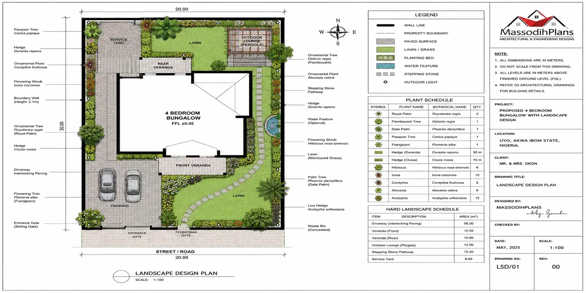
This guide takes you beyond drawing a drain around a building. I will show you how to read the survey, connect topography to drainage, position the building, plan finished floor levels, protect access routes, preserve natural flow paths, and coordinate surface-water drainage with the wider neighbourhood. You will also see site-plan examples, sections, dimensions, Nigerian mistakes, and a pre-construction drainage checklist to use before approving your house position and foundation level.
The emphasis on drainage, site levels, runoff, and surrounding properties is important in Nigeria, where planning guidance considers surface and groundwater movement and topography, while regulations require stormwater drainage provisions.
Drainage Is a Site Planning Decision, Not a Construction Task
Site planning is the process of deciding how a building sits on its plot its position, its orientation, its ground level, its access, its relationship to the boundary. Drainage belongs inside that list, at the same stage as setbacks and orientation, not after them.
Here’s why the sequencing matters. Your building’s ground floor level, its position relative to the road, the slope of your compound, and even which direction your driveway runs are all decisions that either work with water or fight it. Decide all of that first, based on your floor plan and aesthetic preferences alone, and then try to “add drainage” afterward, and you are no longer designing a drainage solution you are managing a problem you built into the site.
I have reviewed enough completed projects to say this plainly: almost every serious drainage failure I’ve been called in to assess traces back to a site planning decision made without drainage in mind, not to poor construction of the drainage system itself.
Reading a Plot Before You Commit: What to Actually Check
Most drainage problems are visible before you ever break ground, if you know what to look for. This is the stage almost nobody spends enough time on, because it happens before the exciting part choosing a house plan and feels like a delay rather than protection.
Visit During Rain, Not Just on a Dry Day
A plot that looks perfectly flat and dry on a sunny inspection can reveal itself completely differently during an actual downpour. If you can, visit the plot while it’s raining, or immediately after a heavy rain. Look at where water sits, where it moves, and how long it takes to clear. A plot that’s still holding water two hours after rain has stopped is telling you something a dry-day visit never will.
Read the Plot’s Position Relative to the Road
Land that sits lower than the street level is a warning sign, not necessarily a dealbreaker. Road drainage is designed to move water away from the road which means a plot lower than the road is often exactly where that water goes. If your plot sits below road level, ask specifically how much fill will be needed to raise it, and price that into your budget before you fall in love with the land.
Check How Neighbouring Compounds Handle Water
Walk the immediate neighbourhood, not just your plot. Do neighbouring compounds show erosion channels, algae staining on walls at ground level, or raised entrance steps that suggest they’ve already fought a flooding battle? Ask directly, if you can, whether nearby residents have had flooding issues. People who’ve lived through a rainy season on that street know things a land agent won’t volunteer.
Understand the Soil, Not Just the Surface
Sandy soil drains fast but can be structurally soft; clay soil holds water and drains slowly, increasing the risk of surface pooling and pressure against foundation walls. A soil test tells you this precisely, but even informally, ask how quickly puddles disappear from the plot and surrounding land after rain slow-draining ground needs a fundamentally different drainage and foundation strategy than free-draining ground.
Note the Plot’s Natural Slope and Direction
Every plot, however subtly, slopes somewhere. Identifying that direction before you design tells you where water naturally wants to go and a good site plan works with that direction rather than against it, directing water along its natural path toward a proper outlet instead of forcing it uphill or across the building’s footprint.
Before you finalize land purchase, ask the seller or agent directly what happens to that plot during the heaviest rains of the year. Their answer, or their reluctance to answer, tells you almost as much as a site visit does.
The Vocabulary Every Site Plan Needs: How Water Actually Moves
You don’t need to become a civil engineer, but understanding a handful of concepts changes how you read and question any site plan or drainage proposal presented to you.
Catchment area
Is the total surface roof, compound paving, driveway, any hard surface that contributes rainwater to a single drainage point. A bigger catchment area needs a bigger drainage capacity to handle it, which is why compound size and paving choices directly affect how large your drainage channels need to be.
Runoff
Is rainwater that doesn’t soak into the ground and instead flows across a surface. Impermeable surfaces concrete paving, block-paved driveways, the building’s own footprint generate high runoff. Grass, gravel, and permeable paving absorb some water instead of shedding all of it, which is why an all-concrete compound floods faster and harder than one with some soft, permeable ground retained.
Invert level
Is the internal base level of a drainage pipe or channel at a given point essentially, how deep the actual water-carrying channel sits. Drainage only works if invert levels fall consistently toward the outlet; a channel with an incorrect or inconsistent invert level will hold standing water instead of carrying it away, regardless of how well-built the channel walls look.
Gradient/fall
Is the slope built into a drainage channel or compound surface to make water move by gravity toward an outlet. Without adequate fall, water sits rather than flows this is one of the most common on-site construction errors, where a drainage channel is built to look right but wasn’t actually leveled to fall correctly toward its exit point.
Outfall
Is where your site’s water ultimately discharges a street drain, a natural watercourse, or an on-site soak-away. Every drainage decision on your plot is meaningless if it doesn’t resolve to a working outfall; a beautifully built perimeter channel that empties into a blocked or non-existent street drain has simply relocated the problem to your gate.
How Drainage Should Shape Your Site Plan, Step by Step
This is the sequence I actually use when drainage genuinely leads the site planning process, rather than following it.
1. Set the Building’s Ground Floor Level First
Before finalizing the floor plan’s internal layout, establish how high the ground floor needs to sit relative to the surrounding compound and the road. In flood-prone or low-lying plots, this often means the finished floor level sits 30-60cm or more above the natural ground level a decision that affects your foundation design, your entrance steps, and your budget, and one that has to be made before, not after, the architectural design is finalized.
2. Plan the Compound’s Fall Before You Plan Its Paving
Decide which direction the compound surface will slope, and toward which outlet, before deciding what material will cover it. A beautifully paved compound with no built-in fall will pool water regardless of how attractive the paving pattern is the fall has to be engineered into the ground preparation stage, not assumed to happen naturally.
3. Position the Building to Work With the Plot’s Natural Slope
Where possible, position the building so that roof and compound runoff can flow toward the plot’s naturally lower side and its intended outlet, rather than across the building’s own footprint or toward a neighbour’s boundary. Fighting the plot’s natural slope with the building’s position is one of the more expensive site planning mistakes to correct later.
4. Design the Perimeter Drainage as Part of the Site Plan, Not an Add-On
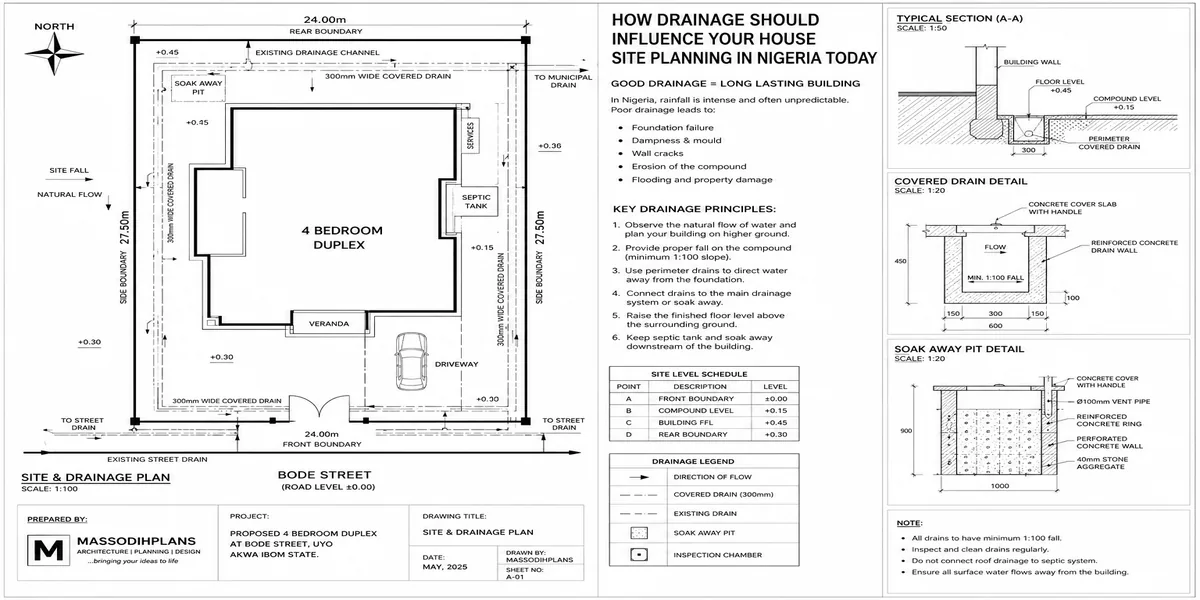
A perimeter drainage channel around the building collecting roof runoff via gutters and downpipes, plus surface runoff from the compound should be drawn into the site plan at the same stage as the building’s footprint, with a clear, continuous fall toward a genuine outfall. Adding this as an afterthought after paving is complete typically means breaking already-finished surfaces to retrofit it properly.
5. Decide Your Outfall Strategy Before You Need It
If your street has a functioning public drainage channel, your site plan should show exactly how your perimeter drainage connects to it. If it doesn’t a genuine reality on many streets across rapidly developing Nigerian neighbourhoods your site plan needs a designed on-site solution, typically a soak-away sized correctly for your plot’s catchment area and local soil permeability, decided at the planning stage rather than improvised during construction.
6. Account for Driveway and Access Drainage Separately
Driveways are often the most overlooked drainage surface on a plot, because they’re designed for vehicle access first and water movement second, if at all. A driveway that slopes toward the building, rather than away from it, quietly directs a significant volume of runoff straight at your foundation every time it rains this needs correcting at the site planning stage, not the paving stage.
7. Preserve Some Permeable Ground Where the Plot Allows
Where plot size allows it, deliberately retaining some unpaved, permeable ground a planted strip, gravel area, or lawn reduces the total runoff your drainage system has to handle. On tightly built urban plots where this isn’t feasible, that lost absorption capacity has to be compensated for with a larger-capacity drainage and soak-away design.
The National Building Code requires site plans to properly account for drainage and invert levels as part of preventing site flooding, and increasingly, structural project supervision by a COREN-registered engineer is expected to confirm this compliance. Confirm current documentation and supervision requirements with your specific state’s building control authority, since exact procedures and enforcement have continued to evolve.A properly prepared site plan should account for invert levels to prevent flooding, and by law, a COREN registered engineer must supervise the structural integrity of the project to ensure it meets the National Building Code.
Types of Site Drainage Systems and When Each One Actually Applies
Not every plot needs the same drainage solution, and choosing the wrong one for your specific site conditions is its own category of costly mistake.
Perimeter surface channels open or grated channels running around the building’s base work well as the primary system on most standard urban plots, provided they have a correct, continuous fall to a real outfall.
Soak-aways a below-ground chamber or pit designed to let collected water disperse gradually into surrounding soil are essential where no functioning public drain exists nearby, but only work reliably in soil with adequate permeability. On heavy clay soil, an undersized or poorly sited soak-away simply becomes a hidden reservoir of standing water beneath your compound.
Piped drainage enclosed pipes carrying water from collection points to an outfall suit situations where surface channels would conflict with driveways, walkways, or where a cleaner finished appearance is wanted, but require correct pipe sizing and gradient, and are harder to inspect and unclog than open channels.
Interceptor/cut-off drains positioned at the boundary facing higher ground, these intercept water flowing onto your plot from a neighbouring or higher-lying property before it ever reaches your building. These are frequently the missing piece on plots that flood despite having reasonable on-site drainage, because the actual water source is arriving from outside the plot boundary entirely.
Elevated foundations and raised ground floors not a drainage system in themselves, but a structural response used in genuinely flood-prone or low-lying areas where no combination of channels and soak-aways can fully resolve the site’s exposure, particularly relevant in coastal and riverine parts of the country.
Drainage Realities Across Different Nigerian Cities
Drainage planning cannot be generic across Nigeria, because the underlying conditions genuinely differ by region.
In Lagos and other low-lying coastal areas, high water tables, reclaimed land, and heavy seasonal rainfall combine to make elevated ground floor levels, robust soak-away or piped systems, and careful attention to public drain connections particularly critical building as though you’re on firm, well-draining ground when you’re actually on reclaimed or waterlogged land is a recurring and expensive mistake.
And in Port Harcourt and much of the Niger Delta, high rainfall volumes and often high water tables demand similar caution, with particular attention to soak-away performance, since heavy clay and waterlogged conditions are common across parts of the region.
In Abuja and similar elevated, undulating terrain, the concern shifts more toward erosion fast-moving runoff on sloped land can erode compound surfaces and undermine foundations at the base of a slope if channels aren’t designed to slow and safely direct water rather than simply let it run downhill unchecked.
Also in older, unplanned urban neighbourhoods across many Nigerian cities, the absence of any functioning public drainage infrastructure means your on-site solution effectively has to function as a complete, self-contained system, since there is often no reliable outfall to connect to beyond your own boundary.
Whatever city you’re building in, the underlying principle stays the same: understand your specific site’s rainfall, soil, slope, and surrounding infrastructure before designing your drainage response, rather than applying a generic solution because it worked for a different plot elsewhere.
Drainage Mistakes That Are Expensive to Fix After the Fact
Finalizing the floor plan and ground floor level before checking the plot’s drainage needs this often means retrofitting a raised floor level after foundation work has already begun, at significant added cost
Paving the compound before establishing correct fall flat or incorrectly sloped paving has to be broken up and relaid to fix, rather than simply adjusted
Treating perimeter drainage as a finishing-stage addition channels added after landscaping and paving are complete typically require cutting into finished surfaces
Ignoring water arriving from a neighbour’s higher-lying plot a well-executed on-site drainage system can still fail completely if it wasn’t designed to handle water entering from outside the boundary
Installing a soak-away without checking soil permeability an undersized or poorly sited soak-away in clay-heavy soil becomes a hidden problem rather than a solution
Connecting to a street drain without confirming it actually functions a channel that empties into a blocked, silted, or non-existent public drain has simply moved the flooding point to your gate
A Practical Drainage Checklist Before You Approve Your Site Plan
- Has the plot been visited during or immediately after rainfall, not only on a dry day?
- Is the plot’s level relative to the road known, and if it sits below road level, has fill cost been budgeted?
- Has the plot’s natural slope and drainage direction been identified and used to inform the building’s position?
- Does the site plan show the finished ground floor level explicitly, and does it account for flood risk specific to this plot?
- Does the compound paving plan include a defined fall toward a genuine outlet, not just a finished surface pattern?
- Is the perimeter drainage system drawn into the site plan itself, with continuous invert levels falling toward a confirmed outfall?
- Has water potentially arriving from neighbouring or higher-lying plots been accounted for, not just water generated on-site?
- If a soak-away is planned, has soil permeability actually been checked, rather than assumed?
- Does the driveway’s slope direct water away from the building rather than toward it?
- Has the local public drainage infrastructure been confirmed functional, not just present?
Ask your architect or site planner to walk you through the drainage strategy on your site plan specifically where water starts, where it moves, and where it finally exits the plot before you approve the plan. If they can’t answer that clearly in under two minutes, the drainage hasn’t actually been designed yet; it’s been assumed.
Frequently Asked Questions
Should drainage be considered before or after choosing a house plan?
Before, ideally at the same stage as setbacks and orientation. The plot’s drainage needs should influence the building’s ground floor level and position, which in turn shapes what floor plan is realistically buildable on that specific site.
How do I know if a plot has a drainage problem before I buy it?
Visit during or right after rain if possible, check the plot’s level relative to the road, look for erosion or water staining on neighbouring compounds, and ask residents directly about past flooding on that street.
Is a soak-away always the right drainage solution in Nigeria?
No. Soak-aways work well where soil permeability is adequate, but perform poorly in heavy clay or already-saturated ground. Soil condition has to be checked before choosing this as your solution, not assumed.
What is an invert level, and why does it matter for my site plan?
It’s the internal base level of a drainage channel or pipe at a given point. Drainage only functions if invert levels fall consistently toward an outlet inconsistent levels cause standing water even in a well-built channel.
Can good drainage design actually prevent flooding on a low-lying plot?
It can significantly reduce risk, particularly combined with a raised ground floor level and a properly sized outfall strategy, but a genuinely low-lying, poorly draining plot will always carry more inherent risk than a well-positioned one good drainage design manages that risk, it doesn’t eliminate the underlying site condition.
Conclusion
The houses that stay dry through a Nigerian rainy season were rarely lucky. Their drainage was decided early before the floor plan was finalized, before the compound was paved, before anyone chose a tile as a genuine site planning decision rather than a repair made after the first flood. If you take one thing from this guide into your own project, let it be sequencing: read the plot’s water behaviour first, let it shape your ground level and building position, and only then finish the rest of the design around it.
If you’re still choosing land or finalizing a site plan, our Services page covers site plan analysis specifically for Nigerian plots setbacks, access, and drainage together. Browse our Plans Library for house plans designed with real Nigerian site conditions in mind, or visit Plan School to build your own understanding of site planning fundamentals. You can also explore more building guides on our Homepage.
Related articles to complete the lesson
- How Topography Influences Flooding Around Nigerian Homes and Cities Today
- How to Understand Land Use Before Buying Property in Nigeria Safely
- How Land Use Affects the Type of Building You Can Develop in Nigeria Today
- 10 Things to Check Before Building a House on Any Plot in Nigeria Today
- How to Evaluate Land in Lagos Before Choosing a House Plan to Build Safely (15 Best Ways)
- How to Choose the Right Residential Location in Abuja Before You Build (20 Best Areas Ranked for Buildability)
- How to Choose the Right Residential Location in Lagos Before You Build
- 10 Things to Check Before Building a House on Any Plot in Nigeria Today
- How to Choose the Right House Plan Based on Your Plot Size in Nigeria Today
- How GIS Can Help You Choose the Right Land for Your Dream House in Nigeria
- How to Identify Flood Risk Before Building a House in Nigeria Today, Safely
- How to Analyse a Building Site Before Choosing a House Plan in Nigeria
- How to Check a Plot of Land Before Buying It in Nigeria: Complete Guide
- How to Choose the Right Land for Building a House in Nigeria Safely Today
- How Much Does It Cost to Build a House in Nigeria? Full Guide to Materials, Labour, Foundation, Roofing and Finishing
Author
Massodih Okon is a Nigerian built-environment professional with academic and professional experience in urban and regional planning, geography, architectural design, Landscape Design, GIS and land development.
He holds a Master’s degree in Urban and Regional Planning from the University of Uyo and a first degree in Geography and Regional Planning.
Through MassodihPlans, he publishes practical guides on Nigerian house plans, building design, physical planning, site planning, development approval and residential construction. Read the full author profile →