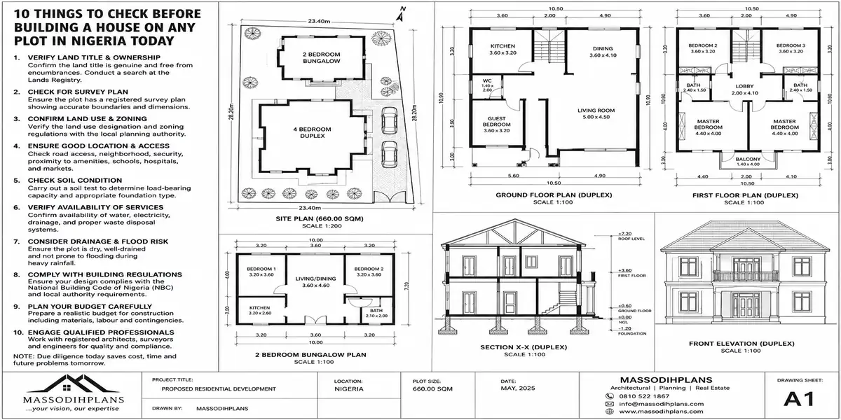
10 Things to Check Before Building a House on Any Plot in Nigeria Today
Introduction
Before you build a house on any plot in Nigeria, don’t start with the house plan start with the land. A beautiful design can become an expensive mistake when the plot has a bad title, weak soil, poor drainage, inadequate access, planning restrictions, or dimensions that cannot accommodate the building you have in mind. In other words, a plot is not truly “good” simply because it is dry, affordable, fenced, or located in a developing neighbourhood.
In this guide, I’ll walk you through the 10 checks I would want you to make before putting a single block on your land. We’ll look beyond the obvious questions and examine the things that can quietly increase your construction cost or create serious problems later: ownership and land documents, survey accuracy, zoning and setbacks, plot size and shape, soil and foundation conditions, flood and drainage behaviour, road access, utilities, sun and wind orientation, and the actual buildable area after all restrictions are considered.
I’ll also show you why two plots with the same square metres can have completely different construction potential and how a seemingly cheap plot can become the more expensive option after filling, retaining walls, difficult foundations, long utility connections, or drainage works are added. ARCON’s site-analysis guidance similarly highlights topography, soil, water table, drainage, climate, orientation, and flood risk as important design considerations.
So, if you already own land, are about to buy one, or have been given a plot by family, stay with me. By the end, you’ll have a practical Nigerian plot-assessment checklist you can use before choosing a house plan, hiring professionals, or spending heavily on construction. This exercise can save money, redesigns, delays, disputes, and avoidable construction headaches.
The Land Use Classification and Permitted Density
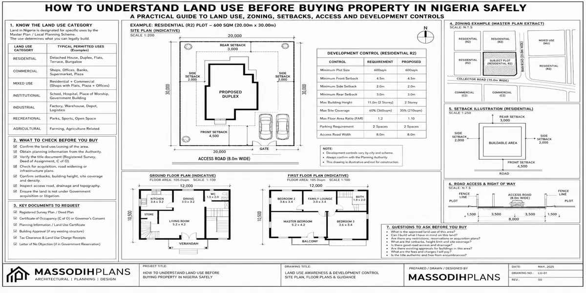
Before anything else, find out how your state’s planning authority has classified the land residential low, medium, or high density; mixed-use; or something else entirely. This single classification determines your maximum plot coverage, permitted building height, and sometimes even the type of building you’re legally allowed to construct.
I have seen clients buy land assuming they could build a 4-storey block of flats, only to discover at the approval stage that the zoning permits only low-density single-family residential development. This isn’t a paperwork technicality you fix later it can mean redesigning your entire project or being unable to build what you’d already budgeted and planned for.
How to check it: Visit your state’s ministry of physical planning or urban development (or the relevant local planning authority) with your survey plan and request the zoning/land use classification for that specific plot, not just the general area classifications can differ plot to plot within the same street.
Ask specifically for the classification in writing, not verbally. Verbal assurances from an agent or even a planning office staff member have no value if a dispute arises later you need a documented classification before you finalize your design brief.
Soil Condition Through an Actual Geotechnical Investigation
Nigeria’s soil condition varies dramatically even within the same city sandy and stable in one area, waterlogged or reclaimed swampland a few streets away. Your foundation design, and therefore a significant part of your budget, depends entirely on what’s actually under the plot, not what’s under the plot next door.
A soil test (geotechnical investigation) tells your structural engineer whether you need a standard strip foundation or a more expensive raft or pile foundation. Skipping this and assuming a standard foundation will work is one of the most common and costly mistakes I encounter — foundation failures discovered mid-construction are far more expensive to fix than the soil test would ever have cost.
How to check it: Commission a soil test from a qualified geotechnical firm before finalizing your structural drawings not after. Costs vary by depth and method but are consistently a fraction of what a wrong foundation assumption costs to correct.
The Real Buildable Envelope After Setbacks
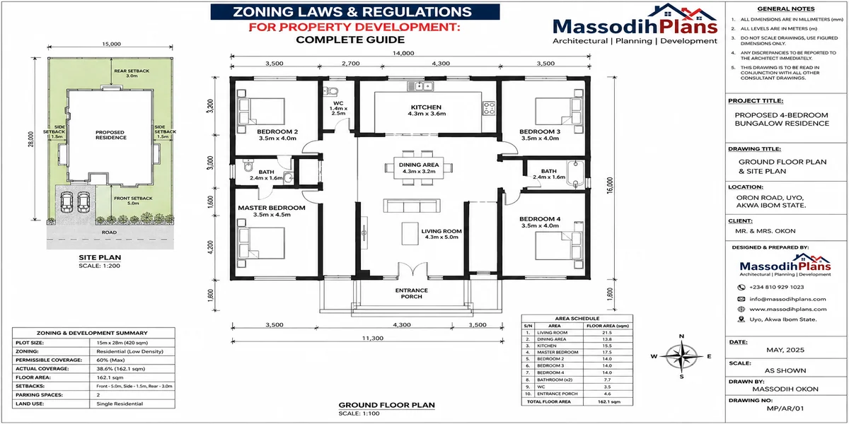
Every plot has a legal size on paper, but your actual buildable area is smaller once mandatory setbacks front, rear, and both sides are subtracted. Many buyers calculate their house size based on the full plot dimensions and only discover the real, smaller buildable footprint after an architect applies the setback rules.
On a standard 450–600 sqm plot, setbacks can easily remove 30–40% of the theoretical building area once you account for front setback, side spacing on both sides, and rear setback. If your house design assumed the full plot size, you will need to redesign usually shrinking rooms or going vertical once this becomes clear.
How to check it: Get your architect or a planning consultant to calculate the actual buildable envelope using your specific plot’s setback requirements before you finalize any floor plan, not after a design you love turns out to be too large for what’s legally buildable.
Setback requirements differ by zoning classification and sometimes by specific local government area. Never assume the setback rules from a plot you’ve built on before apply automatically to a new plot, even in a nearby location.
Topography and Natural Drainage Pattern
How does water actually move across this specific plot, and where does it go? A plot that sits lower than the surrounding land, or that lies directly in a natural water flow path, will flood regardless of how well the house itself is built unless the drainage design specifically accounts for it.
This is different from checking whether the area “floods” generally. A plot can sit in a neighbourhood with no history of flooding and still be the low point that collects water from every surrounding plot once they’re all built up and paved over. Development changes drainage patterns; a plot that drained naturally as bush land can become a flood point once its neighbours are all built, fenced, and paved.
How to check it: Visit the plot during, or shortly after, heavy rain if at all possible, and observe where water sits or flows. Ask your architect or a civil engineer to assess the plot’s relative elevation to its neighbours and the nearest drainage channel, not just to the road.
The Legal Status and Width of the Access Road
An access road that looks fine to drive on today can still be a legal or practical liability. Some access roads are private, informal tracks created by developers without any government-recognized status meaning there’s no guarantee the road will still exist, or exist at its current width, once surrounding land gets developed further.
Road width also matters for construction itself: if the access road can’t accommodate a concrete mixer truck or building material delivery, your construction costs rise from the extra labour needed to manually transport materials the last stretch.
How to check it: Confirm whether the access road is a government-gazetted public road or a private/informal access, and check its current width against what construction vehicles will need. Your surveyor or a local town planning office can usually confirm the road’s legal status.
Proximity to Power, Water, and Drainage Infrastructure
A plot’s distance from the nearest transformer, water main, or drainage channel directly affects your connection costs and in some cases, whether connection is realistically available at all without you funding infrastructure extension yourself.
I have seen buyers assume “the area has electricity” only to discover after purchase that the nearest usable connection point is several poles away, with the cost of extending the line to their specific plot falling on them. The same applies to water supply and drainage connection.
How to check it: Before finalizing a plot purchase, ask specifically about the distance to the nearest transformer, water source, and drainage outfall not just whether the general area “has” these services.
Boundary Beacon Verification Against the Survey Plan
A survey plan is only accurate if the physical beacons on the ground actually match it. Beacons get moved, deliberately or through years of encroachment, disputes, or simple neglect and a plot that looks fine on paper can have real boundary discrepancies on the ground.
Building based on beacons that don’t match your actual survey coordinates can mean your foundation ends up partly on a neighbour’s land, or your setback calculations are based on a boundary that isn’t actually where you think it is both are expensive, sometimes legally serious, mistakes to discover after construction starts.
How to check it: Engage a licensed surveyor to physically re-verify the beacon positions against your survey plan and coordinates before construction begins, especially if the land has changed hands more than once or sat vacant for years.
Do this beacon re-verification even on land you’re confident about. It’s a relatively small cost for the certainty it provides, and it protects you from a dispute that could otherwise surface years after you’ve already built.
Environmental and Prior Land Use History
What was this land used for before you bought it? A former dumpsite, a filled-in wetland, an area with a history of erosion, or land close to industrial activity can all carry hidden risks unstable fill soil, contamination, or ongoing subsidence that a standard title check will never reveal because none of it shows up on a Certificate of Occupancy.
Reclaimed or “sand-filled” land, increasingly common in developing coastal and low-lying areas, needs particular scrutiny: how the land was filled, how long ago, and whether it has been allowed to properly settle before construction, all affect foundation stability.
How to check it: Ask long-term residents or local community members about the land’s history, not just the seller. Where reclamation or filling is suspected, this should directly inform your soil test scope flag it specifically to your geotechnical engineer.
Community and Communal Land Risk Beyond the Title Document
This goes further than the standard “verify the title” advice you’ll find everywhere else. Even a plot with a genuine, verified Certificate of Occupancy can sit within land where communal or family ownership disputes are ongoing at a level that doesn’t show up in a government title search the well-known “omo-onile” risk in many parts of Nigeria, where community members assert informal claims or demand additional payments regardless of documented title.
A clean title from the land registry tells you the government recognizes the ownership. It does not always tell you whether the local community recognizes it the same way, and construction sites without that second layer of local legitimacy have faced real disruption enforced work stoppages, demanded “settlement” payments, even property damage.
How to check it: Beyond the formal title search, speak directly with the community or family the land was historically associated with, and where possible, get local government or community leadership acknowledgment of the transaction, in addition to your government-issued title documents.
Whether the Plot Actually Fits Your Design Brief Not the Other Way Around
This is the check almost nobody frames correctly. Most people find land first and then try to fit their dream design onto it, discovering only at the design stage that the plot’s shape, orientation, or size genuinely can’t accommodate what they wanted forcing a compromised design or expensive plot modifications.
An irregularly shaped plot, a plot with poor solar orientation for your climate needs, or a plot too narrow for the layout you actually want are all things worth knowing before you commit money to the land, not after.
How to check it: If your house design vision is non-negotiable, involve an architect at the land-selection stage, not after purchase a quick feasibility sketch against the actual plot dimensions and orientation can save you from buying land that was never going to work for what you wanted to build.
Why Skipping These Checks Is More Expensive Than Doing Them
Every one of these ten checks costs money, time, or both. But compare that cost against what happens when they’re skipped: a foundation redesign after block work has started, a drainage dispute with a neighbour after construction, a stop-work order over a zoning violation, or a community dispute that halts a site for weeks. Building regulations, including setback requirements, exist for real technical and safety reasons even when they feel restrictive on a small plot and the smarter response to a tight buildable envelope is designing around it, not ignoring it. The same logic applies to every check on this list: each one exists because skipping it has, somewhere, already cost someone significantly more than the check itself. MassodihPlans
None of these ten checks replace the others. A plot can pass the title check, the zoning check, and the soil test, and still fail on drainage or communal recognition. Run all ten before you commit not just the ones that feel most urgent.
Frequently Asked Questions
Is a Certificate of Occupancy enough to guarantee a plot is safe to build on?
No. A Certificate of Occupancy confirms government-recognized title, but it says nothing about soil condition, drainage pattern, zoning-permitted density, communal recognition, or the plot’s real buildable area after setbacks all separate checks.
How much does a soil test cost compared to what it saves?
Soil test costs vary by depth, method, and location, but they are consistently far smaller than the cost of correcting a foundation built on the wrong assumption about ground conditions.
Can I skip the drainage and topography check if the area has never flooded?
Not safely. Development changes drainage patterns over time a plot that drained naturally before its neighbours were built and paved can become a flood point once the surrounding area is developed.
What’s the difference between a title check and a communal land risk check?
A title check confirms government-recognized ownership through official land registry records. A communal land risk check looks at whether the local community or family historically associated with the land also recognizes the transaction a separate and sometimes overlooked layer of risk in parts of Nigeria.
Should I involve an architect before or after buying land?
Before, if your design vision matters to you. A quick feasibility check against the actual plot dimensions, shape, and orientation can reveal whether a plot will genuinely accommodate what you want to build, before you’ve committed money to land that won’t work for it.
Conclusion
Title verification gets all the attention in most “before you build” content because it’s the check people already know to worry about. The ten checks here go further, into the technical and planning-level territory that actually determines whether your project runs smoothly or hits an expensive surprise mid-construction. Run all ten before you commit to a plot, and you convert building from something that happens to you into something you’re genuinely in control of.
For help evaluating a specific plot or turning a verified plot into a buildable design, our Services page outlines how we support clients from land assessment through to approval. Browse our Plans Library for designs already developed around Nigerian plot realities, or visit Plan School to understand the planning and approval process in more depth. You can also explore more land and building guides on our Homepage.
Related Guides
- Semi-Detached House Plans: Modern Duplex and Bungalow Designs With Shared Walls, Dimensions, Costs and Layout Ideas
- Courtyard House Plans: Beautiful 2–6 Bedroom Designs With Private Outdoor Spaces, Floor Plans and Dimensions
- Contemporary House Plans: Modern 2–6 Bedroom Designs With Open Layouts, Large Windows, Dimensions and Costs
- House Finishing Cost in Nigeria: Complete Breakdown of Tiles, Painting, Ceiling, Doors, Plumbing and Electrical Work
- Foundation Cost Calculator: Estimate House Foundation Cost From Soil Type, Dimensions, Materials and Labour
- Block Quantity Calculator: How to Calculate the Number of Blocks Needed for Any House From Your Floor Plan
- Cement Quantity Calculator for Building: Calculate Bags Needed for Foundation, Blockwork, Slab, Plastering and Screeding
- Self-Contained House Plans: 15 Efficient Designs With Room Dimensions, Floor Plans, Building Costs and Ideas
- 1 Bedroom House Plan: Affordable Self-Contained Floor Plans With Dimensions, Materials, Cost and Space-Saving Ideas
Others
- 6 Bedroom House Plans: Modern Nigerian Floor Plans With Dimensions, Ensuite Rooms, Parking and Cost Estimates
- How to Evaluate Land in Lagos Before Choosing a House Plan to Build Safely (15 Best Ways)
- How to Choose the Right Residential Location in Abuja Before You Build (20 Best Areas Ranked for Buildability)
- How to Choose the Right Residential Location in Lagos Before You Build
- 10 Best House Plans for Small Plots in Nigeria: What Buyers Should Consider
- How to Choose the Right House Plan Based on Your Plot Size in Nigeria Today
- How GIS Can Help You Choose the Right Land for Your Dream House in Nigeria
- How to Identify Flood Risk Before Building a House in Nigeria Today, Safely
- How to Analyse a Building Site Before Choosing a House Plan in Nigeria
- How to Check a Plot of Land Before Buying It in Nigeria: Complete Guide
- How to Choose the Right Land for Building a House in Nigeria Safely Today
- How Much Does It Cost to Build a House in Nigeria? Full Guide to Materials, Labour, Foundation, Roofing and Finishing
Author
Massodih Okon is a Nigerian built-environment professional with academic and professional experience in urban and regional planning, geography, architectural design, Landscape Design, GIS and land development.
He holds a Master’s degree in Urban and Regional Planning from the University of Uyo and a first degree in Geography and Regional Planning.
Through MassodihPlans, he publishes practical guides on Nigerian house plans, building design, physical planning, site planning, development approval and residential construction. Read the full author profile →