The Document Mix-Up That Costs Landowners Everything: Master Plan vs Site Plan

Two different scales, two different jobs but they must always agree with each other
The question is what is Key Differences between a Master Plan vs Site Plan Every Property Owner Must Know?, here it is straight away answer: a master plan is the big-picture document that organizes an entire area roads, zones, infrastructure for years or decades ahead, while a site plan is the detailed drawing for one specific plot, showing exactly where a building sits, how it’s accessed, and how it connects to the surrounding layout. One plans a neighborhood. The other plans a single piece of land within it.
I have seen this mix-up cause real damage. A client once submitted what he called his “master plan” for approval it was actually a site plan for his single plot. The submission was rejected, not because his drawing was bad, but because he was asking one type of document to do a job it was never designed for. This guide clears up that confusion for good, so you never lose time or money to it again.
What Is a Master Plan?
A master plan is a long-term, area-wide document that guides how a large piece of land a new town, an estate, a district, or even an entire city should grow and function over time. It typically covers:
- Overall land use distribution across the whole area
- Zoning hierarchy (residential, commercial, institutional, industrial zones)
- The road hierarchy and circulation network connecting everything
- Infrastructure planning water, drainage, electricity, sewage at a system-wide level
- Population projections and phased development over years or decades
Think of a master plan as the skeleton of an entire community. Every site plan within that area should fit into it, not fight against it.
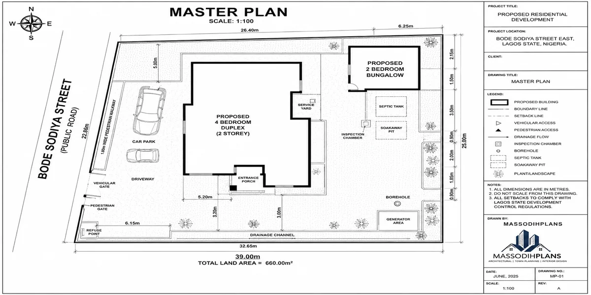
master plan for a plot
What Is a Site Plan?
A site plan is a detailed, plot-specific drawing that shows exactly how one piece of land will be developed. It typically includes:
- Exact building footprint and orientation on the plot
- Setbacks from all boundaries
- Access points, driveways, and parking arrangement
- Drainage, utility connections, and septic or sewage tie-ins specific to that plot
- Landscaping and open space within the plot boundary
In practical terms, what usually happens is this: the master plan tells you what your plot is zoned for and where your access road sits; the site plan tells you precisely how your building will occupy and use that plot within those rules.
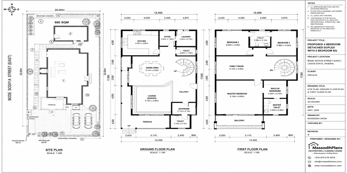
site plan for a plot in lagos
Key Differences at a Glance
| Aspect | Master Plan | Site Plan |
|---|---|---|
| Scale | Entire area, estate, or town | Single plot |
| Timeframe | Years to decades | One project/build |
| Focus | Zoning, circulation, infrastructure systems | Building placement, setbacks, access |
| Prepared by | Town planners, often with government input | Planner, architect, or surveyor for the owner |
| Changes needed | Rare, requires formal review | Common, adjusted per project |
Land Use Distribution: Where It Belongs
Land use distribution is decided at the master plan level. This is where percentages are assigned to residential, commercial, institutional, and open space uses across the whole area usually something like 45–60% residential, 15–25% roads, 10–15% open space, and the remainder split between commercial and institutional use. A site plan does not redistribute land use; it simply operates within whatever the master plan has already assigned to that plot.
Zoning Hierarchy and How It Connects the Two
Zoning is the bridge between master plan and site plan. The master plan sets the zone (say, low-density residential). The site plan must then respect everything that zone implies permitted building types, density limits, and use restrictions. This is one of the most common misconceptions I encounter: people think zoning is a site-level decision. It isn’t. It flows down from the master plan.
Circulation Systems and Road Hierarchy
At master plan level, road hierarchy is designed system-wide: arterial roads connecting the area to the wider region, collector roads gathering local traffic, and local access roads serving individual plots. At site plan level, the only road decision left is how that one plot connects the driveway, the access point, and any required visibility splay at the junction.
Plot Arrangement and Physical Planning Standards
The master plan decides plot sizes, frontages, and general arrangement across the whole layout. The site plan then applies physical planning standards to one plot specifically setbacks, plot coverage ratio, height limits relative to plot size and road width. During studio exercises at university, we constantly practiced exactly this: taking a master plan’s rules and translating them into a compliant site plan for an individual building.
Infrastructure Planning: System vs. Connection
Infrastructure planning happens at two levels, and confusing them causes real delays:
- Master plan level: reserving corridors for water mains, electricity distribution, sewage trunk lines, and drainage channels across the whole area
- Site plan level: showing exactly how one plot taps into those systems: the connection point, meter location, and any on-site tank or treatment need
One challenge I repeatedly encountered during my internship was clients trying to design their site’s water connection without first checking whether the master plan had even reserved a water corridor near their plot. You cannot connect to infrastructure that was never planned to reach you.
Flood Control and Drainage Systems
The master plan identifies floodplains, natural drainage channels, and area-wide stormwater capacity. The site plan then shows plot-level drainage how water moves off that specific roof and yard into the wider system. I have worked with clients who wanted to build directly on what looked like a dry natural channel; the master plan’s drainage layer would have shown them, before they spent a cent, that the channel floods every rainy season.
Environmental Management and Open Space Allocation
Open space and green area allocation is a master plan decision parks, buffer zones, and protected wetlands are reserved at that level. A site plan respects those boundaries and may add its own landscaping within the plot, but it cannot create or remove area-wide green space on its own authority.
Development Control and the Approval Process
Development control checks whether a site plan actually complies with the governing master plan and zoning. A typical process looks like this:
- Confirm the master plan and zoning that apply to the area
- Prepare the site plan in compliance with those rules
- Submit to the relevant planning authority for technical review
- Site inspection
- Approval, conditional approval, or required revision
Based on projects I have worked on, developers who check the master plan and zoning before commissioning a site plan save significant time, because their site plan is compliant from the first draft rather than being sent back for correction.
Population Projections and Urban Growth Strategy
Master plans are built around projected population growth deciding how an area should expand over 10, 20, or 50 years without overwhelming its infrastructure. Site plans don’t need to model population growth; they need to fit within capacity the master plan has already accounted for.
Smart Growth and GIS Integration
Modern master plans increasingly use GIS to overlay topography, flood risk, and existing infrastructure across an entire area before zones and roads are finalized. Site plans can then be checked against this same GIS data to confirm a specific plot doesn’t sit on a hazard the master plan flagged.
Global Reality Layer: How Different Countries Handle This
The master plan and site plan relationship exists everywhere, though the names and legal weight attached to each document vary by country:
Nigeria
State governments prepare master plans (or regional/state layout plans), while individual developers submit site/building plans for Development Control approval, which must conform to the applicable master plan or zoning designation.
United States
Municipalities adopt Comprehensive Plans (the master plan equivalent) and zoning ordinances; developers then submit site plans for review against those zoning rules, often through a Planning Commission process.
Canada
Provinces require municipal Official Plans, with site-specific development applications assessed for conformity against both the Official Plan and local zoning bylaws.
United Kingdom
Local Plans set the area-wide policy framework; individual developments require planning permission, supported by detailed site plans assessed against that Local Plan.
Australia
State and territory planning schemes function as the master plan layer, with local councils reviewing site-specific development applications for compliance.
Switzerland
Cantonal structure plans and municipal zoning plans set the area-wide framework, within which individual building projects require a site-specific building permit application.
Germany
The Flächennutzungsplan (land use plan) works at the broader municipal level, while the Bebauungsplan (binding land-use plan) and site-specific building applications operate at plot level.
Norway
Municipal master plans set overall direction, with detailed zoning plans (reguleringsplan) and site-specific building applications required for individual projects.
New Zealand
District Plans function as the area-wide framework under the Resource Management system, with resource consent applications serving the site-plan function for individual developments.
Netherlands
The structuurvisie (structure vision) guides area-wide policy, while the bestemmingsplan and site-level building permit applications govern individual plots.
Sweden
Municipal comprehensive plans set broad direction, with detailed development plans (detaljplan) and building permits operating at the site level.
Denmark
Municipal plans set the area-wide framework, with local plans (lokalplan) and building permits handling individual site development.
Ireland
County or city Development Plans set the master framework, with individual planning permission applications serving as the site-plan equivalent.
Luxembourg
The general development plan (PAG) sets area-wide zoning, while particular development plans (PAP) and building authorizations handle individual sites.
Austria
State-level spatial planning sets broad direction, with municipal zoning plans and site-specific building permits governing individual projects.
Singapore
The Urban Redevelopment Authority’s Master Plan is the statutory area-wide document; individual developments then require planning permission and detailed submission against it.
Belgium
Regional spatial structure plans set area-wide direction, with municipal zoning plans and individual building permits handling site-level development.
France
The Plan Local d’Urbanisme (PLU) is the master plan equivalent at municipal level; individual projects require a permis de construire supported by a detailed site plan.
United Arab Emirates
Development authorities issue master plans for large districts or master communities, within which individual plot owners submit site/building plans for approval.
Finland
General plans set broad municipal direction, with detailed plans (asemakaava) and building permits governing individual sites.
South Africa
Municipal Spatial Development Frameworks act as the master-plan layer, with site development plans and building plan approvals handled at the individual property level.
Whatever the country, the same rule holds: the site plan must always answer to the master plan above it, never the other way around.
Human Lifestyle Layer
For an ordinary family, this difference matters more than they realize. A site plan can only make a house comfortable orientation, ventilation, privacy. But it cannot fix a bad master plan. If the wider area has no proper roads, drainage, or park space, no amount of clever site planning on one plot will protect that family from congestion, flooding, or noise coming from outside their boundary.
Construction Experience Layer
On every project I’ve handled, the site plans that sailed through approval were the ones prepared with the master plan open beside them from day one. The ones that got stuck were almost always trying to force a plot-level design onto land whose zoning or access simply didn’t support it.
Investment Layer
For property developers, understanding this distinction protects capital. Before buying land, check whether it sits within an approved master plan or zoning framework at all because a beautiful site plan means nothing if the underlying area has no legal development recognition. Land within a recognized master plan is dramatically safer, and more valuable, than land developed purely on individual site plans with no governing framework above them.
Mistakes to Avoid
- Submitting a site plan and calling it a master plan (or vice versa)
- Designing a site plan before confirming the area’s zoning and master plan status
- Assuming a good site plan can compensate for a poorly planned wider area
- Ignoring access and infrastructure corridors set at master plan level
- Buying land with no reference to any governing master plan or zoning framework
Quick Summary
A master plan organizes an entire area for the long term zoning, roads, infrastructure. A site plan applies those rules to one specific plot building placement, setbacks, and connections. Every site plan must conform to the master plan governing its area, never contradict it.
Frequently Asked Questions
Can I get my site plan approved without reference to a master plan?
In most systems, no approval authorities check site plans against the area’s zoning or master plan designation before approving them.
Which document should I request first when buying land?
Always ask for the master plan or zoning status of the area first; the site plan for your specific plot comes after you confirm what that land is legally permitted to be used for.
Can a master plan be changed to accommodate my site plan?
Occasionally, through a formal variation process, but this is far more time-consuming and costly than designing your site plan to fit the existing master plan from the start.
Does every plot need its own separate site plan?
Yes, even plots within the same estate or master plan each require their own site-specific plan showing exact building placement and connections.
Conclusion
Knowing the difference between a master plan and a site plan isn’t just planning jargon it’s the difference between a smooth approval process and months of frustrating back-and-forth. Confirm the master plan governing your area first, then let your site plan fit into it properly from day one.
If you already know your zoning and want a ready-made design, browse the Plans Library. If you need a custom site plan prepared for your specific plot, explore our Services. New to the process entirely? Our Plan School walks you through it step by step, and the Homepage has everything else MassodihPlans offers.
Reference: Useful for urban planning and master planning principles.
To complete this lesson read the following:
- Cost of Master Plan Preparation for Communities and Institutions
- Master Plan Preparation Process Explained Step by Step
- What Is a Master Plan and Why Does Every Growing Community Need One?
- What Happens When a City Develops Without a Master Plan
- How a State Master Plan Works: A Complete Guide to Modern Infrastructure Development
- Industrial Estate Layout Design in Nigeria: Smart Master Plan for Small Industrial Plots
- Small Residential Estate Layout Design in Nigeria: Smart Master Plan Ideas for Limited Land
- Nigerian Estate Master Plan for Small Plots: Modern Residential Layout Strategies That Maximize Space
- Town Planning Services: Plans, Permits and Land Development
- Site Development Plan Cost: What Every Property Owner Must Know Before Building
- Estate Layout Plan Explained for Property Developers and Landowners: Complete Guide
- Landscape Design Cost Calculator for Residential Projects: Estimate Your Landscaping Budget Accurately
- Building a House in Nigeria While Living Abroad: Complete Approval and Documentation Guide
- How GIS and Mapping Can Improve Residential Site Planning in Nigeria Today
- How to Read a Satellite Image Before Buying Land in Nigeria: Full Guide
- How GIS Can Help Identify Flood-Prone Areas Before You Build in Nigeria
- How to Analyse Your Plot Using Satellite Imagery Before Building a House
- How to Use Satellite Maps to Study Land Before Buying Property in Nigeria
- How Wind Direction Can Influence House Planning and Natural Ventilation
- How Sun Orientation Affects Residential Building Design in Nigeria Today
- How Nigeria’s Climate Should Influence Your House Design and Site Planning
- How Natural Water Flow Can Affect Your Building Site and House Plan Today
Author
Massodih Okon is a Nigerian built-environment professional with academic and professional experience in urban and regional planning, geography, architectural design, Landscape Design, GIS and land development.
He holds a Master’s degree in Urban and Regional Planning from the University of Uyo and a first degree in Geography and Regional Planning.
Through MassodihPlans, he publishes practical guides on Nigerian house plans, building design, physical planning, site planning, development approval and residential construction. Read the full author profile →