Before You Build That House, Read This First: Site Development Plan Cost: What Every Property Owner Must Know Before Building
Site Development Plan Cost: What Every Property Owner Must Know Before Building
A site development plan will cost you between ₦150,000 and ₦2,500,000 in Nigeria depending on the size of your land, the location, the complexity of the layout, and the professional handling the job. That is the direct answer. But if you walk away from this page with just that number, you will have missed the most important part.
Because the real cost of NOT having a site development plan is not money. It is flooding. And it is demolition. It is your family living beside an industrial facility that was approved because no proper layout guided the area. Also it is your children walking on narrow, dangerous paths because no road hierarchy was planned. It is the slum that starts three plots away and eventually swallows your estate.
I have seen this happen. Not once. Many times. Across multiple states in Nigeria.
I trained at the University of Uyo. I have reviewed hundreds of site plans, supervised physical development across Nigerian states, and watched communities transform from organised settlements into unmanageable chaos, not because the people were bad, but because nobody sat down to plan.
This guide is for you if you are a property owner, a developer, a community leader, or a government official who wants to understand what a site development plan truly involves, what it costs, and why it is the most important document your land will ever carry.
Let us talk honestly. No jargon. No textbook language. Just real planning knowledge from real field experience.
What Is a Site Development Plan? Let Me Explain It Simply
Think of a site development plan as the master instruction manual for a piece of land. Before any building goes up, before any road is marked, before any plot is sold, the site development plan tells everyone what goes where, how big it should be, how far from the boundary it must sit, and how it connects to the world around it.
In my experience, many Nigerians confuse a site development plan with a building plan. They are not the same thing.
A building plan tells you how one house should look inside and outside. A site development plan tells you how the entire land, whether it is one plot or five hundred plots, should be organised for human beings to live in comfortably, safely, and sustainably.
At the University of Uyo, one thing our lecturers constantly emphasised was that a site is not just land. It is a system. It has drainage patterns, soil characteristics, access corridors, neighbouring land uses, and future growth pressures. The site development plan is what translates all of those realities into a workable layout.
Without it, what you have is not a development. You have a random collection of buildings waiting to become a problem.
Why This Matters So Much in Nigeria Today
I want to spend a moment here because this is where many people switch off. They think planning is a government problem, not their problem. Let me show you why that thinking is wrong.
From what I have seen in practice, the consequences of unplanned development do not stay in government offices. They come into your compound.
If your area has no proper site development plan:
- Your road will be narrow because nobody reserved adequate right-of-way
- Your drainage will fail because no engineer designed the channels before buildings came up
- You will have a market, a mechanic workshop, or a poultry farm built beside your bedroom, and there is nothing you can do about it because the land use was never zoned
- Emergency vehicles will not be able to reach you in a crisis because the access roads are too narrow or blocked by development
- Your children will grow up without a park, a playground, or a safe walking path
This is not a theory. I have driven through areas in Akwa Ibom, Rivers, Lagos, and Abuja that were once quietly residential and are now chaotic mixed-use zones nobody can fix without massive demolition and billions in public spending.
The site development plan is what prevents that future from happening to your land.
What a Site Development Plan Actually Contains
This is where I want to slow down and walk you through the real substance of what a good site development plan contains. Not the summary version. The real version. Because when you are paying for this service, you deserve to know exactly what you are getting.
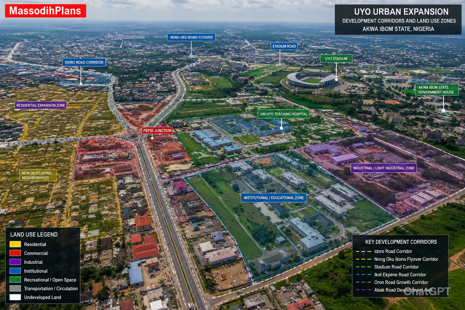
1. Master Plan Concept and Land Use Distribution
The foundation of any site development plan is the master plan concept. This is the overarching vision for how the land will function as a whole.
In one housing layout project I worked on, the client initially wanted to pack as many plots as possible into the land. I understood why. Land is expensive, and maximising plot numbers seems like good business. But I had to sit with him and show him what that decision would cost him long term.
When you crowd plots without proper land use distribution, you eliminate the space needed for roads, drainage, open spaces, schools, and commercial centres. The result is that you may sell 150 plots instead of 100, but the development becomes unliveable within ten years. Property values drop. Occupants leave. What was a premium estate becomes a problem zone.
A good site development plan distributes land use across these categories:
- Residential zones: where people live (low density, medium density, high density)
- Commercial zones: where people trade and run businesses
- Industrial zones: where production happens, located far from residential
- Institutional zones: schools, hospitals, churches, mosques, government offices
- Recreational zones: parks, playgrounds, open fields
- Circulation areas: roads and paths that connect everything
- Utility corridors: electricity lines, water mains, drainage channels
For a typical residential estate, residential uses should occupy roughly 50 to 60 percent of the total land area. Roads and circulation should take between 20 and 25 percent. Open spaces, parks, and recreational areas should claim at least 10 percent.
2. Zoning Hierarchy: The System Behind the Map
Zoning is not just about separating houses from markets. It is a layered system that controls how intensely land is used, what activities are permitted in each zone, and how different zones relate to each other.
During my undergraduate studies in Town Planning, I first encountered the concept of zoning hierarchy, and at the time it seemed abstract. It was only during site analysis assignments and later during my internship that I understood how powerfully it shapes everyday life.
The zoning hierarchy in a Nigerian site development plan typically includes:
- Primary zones: Residential, commercial, industrial, and institutional are the big four
- Secondary zones: Within each primary zone, there are gradations. Low-density, medium-density, or high-density residential. Each has different plot sizes, heights, and densities
- Special use zones: Petrol stations, worship centres, hospitals, markets, and schools
- Buffer zones: Transitional areas between incompatible land uses. A green belt, a road reservation, or a commercial strip that eases the transition
I have seen projects where buffer zones were ignored to save money. The result is always the same: noise complaints, health hazards, conflicts between residents and business operators, and eventually court cases.
3. Circulation Systems and Road Hierarchy
A road is not just a road. In a site development plan, roads form a complete hierarchy, and each level of that hierarchy serves a specific function.
| Road Type | Width | Purpose |
| Arterial Road | 30 to 40 metres | Main access, high traffic volume |
| Collector Road | 18 to 24 metres | Connects arterials to local roads |
| Local Road | 9 to 12 metres | Access to individual plots |
| Service Lane | 4 to 6 metres | Rear access, utilities |
| Pedestrian Path | 2 to 3 metres | Walking, cycling |
One lesson I learned early is that road width decisions made at the planning stage are almost impossible to reverse once buildings go up. I have seen communities struggling to widen roads by half a metre because properties had already been built right to the edge.
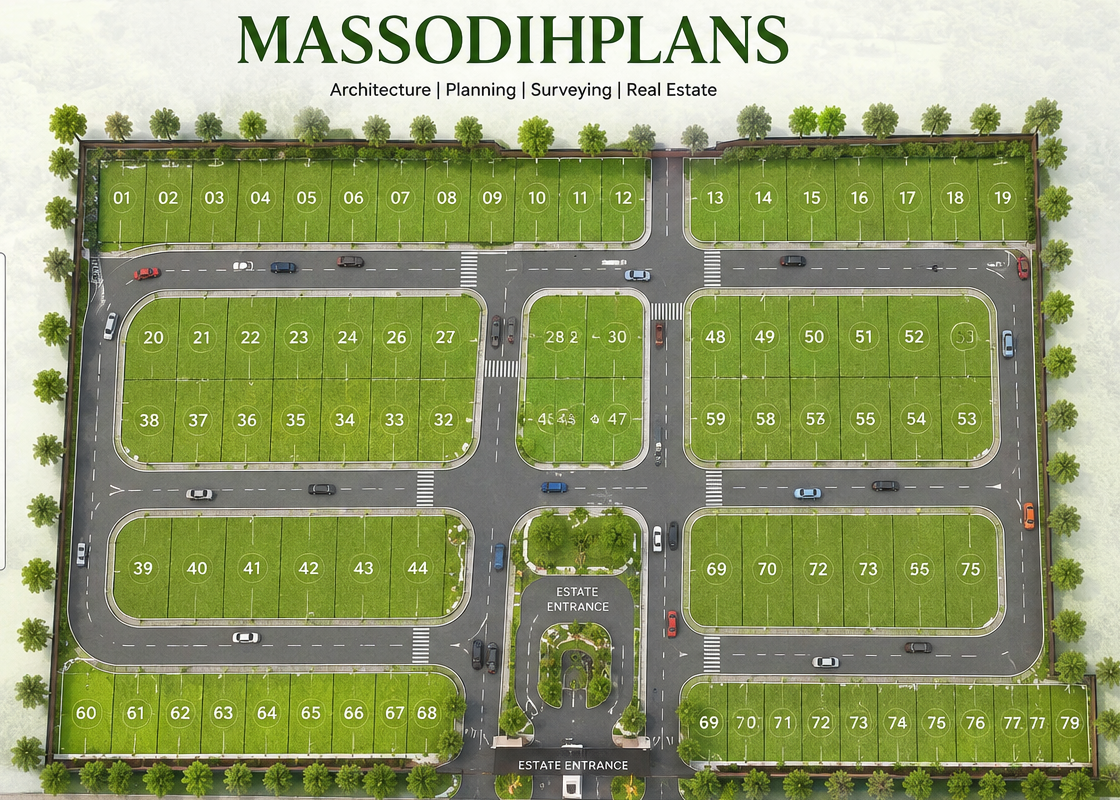
4. Plot Arrangements and Physical Planning Standards
How plots are arranged within a block determines how comfortable and functional the estate will be for residents.
Key planning standards that govern plot arrangements include:
Plot sizes: In Akwa Ibom State, for instance, the standard residential plot in a low-density zone is 648 square metres (18 metres by 36 metres). In high-density zones, smaller plots down to 300 square metres may be approved.
Building setbacks (standard requirements in Nigeria):
- Front setback: 4.5 metres to 6 metres from the road reserve
- Side setback: 1.5 metres to 3 metres from the side boundary
- Rear setback: 3 metres to 4.5 metres from the rear boundary
One practical example comes from a project I handled in Uyo. The client wanted to build right to the edge of his plot on all sides. I had to explain that setbacks are not obstacles created to frustrate property owners. They are safety margins. And they allow light into buildings. They provide ventilation corridors. They create escape routes in case of fire.
5. Infrastructure Planning: Water, Power, Drainage, and Waste
A site development plan that does not address infrastructure is incomplete. And in Nigeria, this is the area where the gap between good planning and poor planning is most painfully visible.
During my internship, I observed that many layout plans produced by unqualified individuals simply drew roads and plots without any thought for how water would flow, how electricity would be distributed, or how waste would be managed. The consequences appear within five years of occupation. Sometimes sooner.
Water supply planning identifies the source, the distribution network, and pressure zones to ensure equitable supply across the estate.
Drainage design is possibly the most critical infrastructure element for Nigerian conditions. A site development plan must map existing natural drainage channels, design engineered channels for storm water, calculate runoff based on the land’s impermeability after development, and ensure outlets to receiving water bodies without causing downstream flooding.
One challenge I repeatedly encountered during my internship was the attitude that drainage design was too expensive and could be handled later. Drainage designed after development costs ten to twenty times more than drainage planned before. And it is never as effective because the buildings are already in the wrong places.
Electricity distribution planning identifies transformer locations, high-voltage line corridors, and the routing of distribution lines.
Solid waste management planning determines collection points, access for collection vehicles, and the location of transfer stations.
6. Flood Control and Environmental Management
Nigeria loses billions in property and infrastructure to flooding every year. A significant portion of this loss is preventable with proper planning. I did not learn this from a textbook alone. I have seen it happen.
A comprehensive site development plan addresses flood risk through:
- Floodplain identification: Areas at high risk of inundation should be kept as open space or green belts, never as residential or commercial plots
- Detention and retention ponds: Designed areas that temporarily hold excess storm water and release it slowly, reducing peak flows
- Permeable surfaces: Parking areas and walkways that allow some rainfall to infiltrate rather than rushing off as surface runoff
- Green corridors and tree planting: Trees stabilise soil, reduce storm water runoff, and reduce the urban heat island effect
7. Development Control Framework
A site development plan is only as good as the rules that accompany it. The development control framework is the set of regulations that will govern what can be built, where, and how, once the layout is approved and plots are sold.
A proper development control framework includes:
- Building regulations for each zone: Maximum heights, minimum setbacks, maximum plot coverage, minimum parking provision, and permitted uses
- Planning permission procedures: Documents required, fees payable, and timelines for decision-making
- Approval and certification processes: Who signs off, who inspects construction, what certificates are issued at completion
- Enforcement mechanisms: Stop orders, penalties, and demolition procedures for violations
Based on my experience, the absence of an effective development control framework is what transforms planned estates into slums over time. The initial plan may be perfect. But if nobody enforces the setbacks, the plan is progressively undermined until nothing of its original integrity remains.
How Much Does a Site Development Plan Cost in Nigeria?
Now let us talk numbers with the honesty this topic deserves.
If I were advising a client today, I would recommend budgeting comprehensively rather than just looking for the cheapest option. The cost of a site development plan reflects the complexity of the work and the competence of the professional doing it. Cutting corners here is like buying cheap cement for a foundation.
Cost Factors That Affect Site Development Plan Fees
- Land size: The most significant factor. A plan for a 2-hectare layout involves far less work than a plan for a 50-hectare estate
- Location: Urban areas with complex neighbouring land uses and utility networks require more detailed analysis
- Scope of work: A basic layout plan is less expensive than one including drainage design, environmental impact assessment, and development control framework
- Professional qualifications: A TOPREC-registered Town Planner will typically charge more than an unregistered practitioner. The difference is accountability and quality
- Client requirements: GIS mapping, 3D visualisations, and phasing studies increase the cost accordingly
Nigerian Site Development Plan Cost Breakdown
| Site Size | Basic Layout Plan | Comprehensive Plan | Full Master Plan Package |
| 0.5 to 1 hectare | ₦150,000 to ₦300,000 | ₦300,000 to ₦600,000 | ₦600,000 to ₦1,000,000 |
| 1 to 5 hectares | ₦300,000 to ₦600,000 | ₦600,000 to ₦1,500,000 | ₦1,500,000 to ₦3,000,000 |
| 5 to 20 hectares | ₦600,000 to ₦1,500,000 | ₦1,500,000 to ₦4,000,000 | ₦4,000,000 to ₦8,000,000 |
| 20+ hectares | ₦1,500,000+ | Professional quotation | Professional quotation |
Note: These are 2024 to 2025 indicative ranges. Actual costs depend on the factors listed above and should be confirmed with your planner.
What Is Included in Each Package?
Basic Layout Plan: Topographic survey integration, road and plot layout drawing, plot numbering, area schedule, basic setback standards
Comprehensive Plan: Everything in Basic, plus drainage channel design, infrastructure service routes, open space allocation, development control guidelines, and planning approval submission package
Full Master Plan Package: Everything in Comprehensive, plus land use distribution report, zoning regulations, environmental management plan, phasing strategy, GIS mapping, population projections, and investment attractiveness report
The GIS and Technology Dimension
In my experience, the best site development plans produced in Nigeria today use GIS (Geographic Information Systems) as a core tool, not as an afterthought.
GIS allows the planner to:
- Overlay topographic data on the layout to identify flood-prone areas
- Analyse access and connectivity for emergency services
- Calculate precise areas for each land use category
- Model drainage catchments and runoff scenarios
- Visualise the development in three dimensions before anything is built
My academic training exposed me to GIS tools at the University of Uyo, and my practical field experience reinforced the value of this technology for producing plans that are accurate, defensible, and easy for approval authorities to review.
When you commission a site development plan, ask your planner whether GIS will be used in the analysis. The answer tells you a great deal about the quality of work you will receive.
Urban Growth Strategy and Future Expansion
A site development plan should not just address today’s development. It should anticipate growth and leave room for the future.
A good urban growth strategy within a site development plan includes:
Population projections: Using demographic data and growth rate assumptions, the planner calculates how many people will live in the development over 10, 20, and 30 years.
Phased development: Large layouts are typically developed in phases. Phasing allows infrastructure investment to match demand rather than building everything upfront.
Expansion corridors: The plan should identify directions for future growth and ensure road layouts and drainage systems can be extended without requiring demolition.
Smart growth concepts: Modern plans incorporate mixed-use planning, walkable neighbourhoods, and transit-friendly layouts that reduce dependence on private vehicles.
The Planning Approval Process in Nigeria
I want to walk you through this because it is an area that confuses many property owners and delays projects unnecessarily.
- Survey Plan: Your licensed surveyor produces and authenticates a survey plan with the state’s Office of the Surveyor General
- Site Development Plan Preparation: Your registered Town Planner prepares the plan in compliance with the Nigerian Urban and Regional Planning Law (Cap N138 LFN 2004)
- Environmental Impact Assessment: For layouts above approximately 5 hectares in most states, NESREA or the state environmental agency requires an EIA
- Submission to Ministry of Physical Planning: The complete package including site development plan, EIA, survey plan, proof of land title, and application forms
- Technical Review: Ministry officers review compliance with planning standards, road widths, setbacks, and land use appropriateness
- Approval and Conditions: Conditions typically include requirements for road construction, drainage provision, and development staging
- Physical Development Commencement: Development begins after all conditions are satisfied
Working alongside experienced planners taught me that the approval process moves faster when the submission is complete, professional, and compliant from the start. Half-complete submissions waste months of back-and-forth time.
Mixed-Use Integration and Community Functionality
One of the most important shifts in modern Nigerian estate planning is the move away from purely residential estates toward mixed-use developments that function as complete communities.
I recently encountered a case where a client wanted to develop a residential estate of 200 plots with no provision for a shopping area, school, clinic, or place of worship. I pointed out that this would create a community of people who had to travel for every basic need, and that in practice, people would eventually convert residential plots to shops and churches anyway, creating the land use conflicts that planning was supposed to prevent.
A well-integrated mixed-use layout provides:
- Neighbourhood commercial strips within walking distance of all residential plots
- Primary school allocation within 500 metres of the farthest residential plot
- Healthcare facility allocation within the estate
- Worship centre zones positioned away from residential cores to minimise noise conflict
- Recreational parks accessible to all residents
This is the approach I would personally take for any layout I am advising on. It costs a little more land allocation upfront. But it produces communities where people actually want to live, and that drives property values up sustainably.
Nigerian Reality Layer: What Nobody Else Will Tell You
The reality of site development planning in Nigeria involves challenges that textbooks and international guides do not address.
Land Tenure Complexity: Many Nigerian properties have layered and sometimes conflicting title documents. I have worked on projects where planning was completed only for us to discover that parts of the land had been sold twice. Always resolve title before planning.
Community and Traditional Authority: In many states, especially in the South-South and South-East, community leaders and traditional rulers have authority over land allocation that runs parallel to statutory planning processes. Engage them respectfully and early.
Infrastructure Realities: A good site development plan in Nigeria must incorporate self-sufficiency for utilities. Plan for boreholes, independent power, and on-site waste management. Do not assume government infrastructure will serve your estate.
Climate Adaptation: Nigeria’s climate involves intense rainfall, high humidity, and increasing extreme weather events. Site development plans must integrate passive cooling principles, shade tree planting, and drainage systems designed for increasingly intense storm events.
Human Lifestyle Layer: How Good Planning Changes Daily Life
Planning is ultimately about human beings and how they live. Let me connect the technical content in this guide to the everyday lives of the people who will occupy these layouts.
When roads are planned properly, children walk to school on safe paths instead of the edge of a busy road. Mothers with groceries do not have to navigate through traffic just to reach their front door.
When drainage is designed before buildings go up, the family in the lowest plot does not spend every rainy season watching water rise in their living room. Their furniture does not get destroyed. Their children do not miss school because the access road is flooded.
When land uses are properly zoned, you sleep without the noise of a generator plant next door. You do not smell a bakery or a chemical factory from your bedroom window.
When setbacks are enforced, fire does not jump from one house to the next because there was no gap between them. Fire trucks can actually reach the burning building.
This is what a site development plan does. It does not just create a layout on paper. It creates the physical conditions for a decent life.
Investment Layer: What Good Planning Does to Property Values
From a planning perspective, I strongly recommend that any investor or developer understand the direct relationship between planning quality and investment return.
The evidence from projects I have worked on points to a consistent pattern: well-planned estates command significantly higher property values than poorly planned ones, even when the underlying land costs are similar.
Developers who invest in quality site development plans from the outset recover that investment in three ways:
Higher plot prices: Buyers in well-planned estates pay premium prices because the quality of the layout is visibly evident.
Faster sales: Well-planned estates sell out faster because the product is more attractive and trustworthy.
Lower dispute costs: When plots are clearly defined and land uses are designated, there are fewer boundary disputes, fewer encroachment problems, and fewer legal costs.
Common Mistakes to Avoid
Mistake 1: Hiring an unregistered person to prepare your site development plan. Only TOPREC-registered Town Planners are legally authorised to prepare plans for approval. A plan from an unregistered person will be rejected, and you will have lost both time and money.
Mistake 2: Starting construction before approval. Unapproved development can be demolished by the government without compensation. I have witnessed firsthand how families lose everything because they chose to build first and ask questions later.
Mistake 3: Maximising plot numbers at the expense of infrastructure. Squeezing extra plots by reducing road widths and eliminating open spaces looks profitable short term. In the medium and long term, it destroys the value of all plots in the estate.
Mistake 4: Ignoring drainage. Nigeria’s climate is not forgiving to poor drainage design. Every rainy season, Nigerians watch billions in property get destroyed by flooding that proper planning could have prevented.
Mistake 5: Treating planning approval as a one-time exercise. Development control continues throughout the construction period and beyond. Maintain that relationship with your state planning authority.
Expert Notes From Field Experience
On roads: The most common planning regret I hear from estate developers is ‘I wish we had made the roads wider.’ Road widths are almost impossible to increase after development. Design them generously from the beginning.
On drainage: Drainage channels in Nigeria’s climate must be designed for a 10-year or 25-year storm event. The difference might be 30 percent more channel capacity. That 30 percent is the difference between minor inconvenience and catastrophic flooding.
On setbacks: Setbacks are friends, not obstacles. They provide ventilation, access for maintenance, fire separation, and visual breathing room. Enforce them diligently.
On green spaces: The open spaces in a site development plan increase the attractiveness and value of every surrounding plot. Protect them from encroachment.
On phasing: Plan your phases so that each phase is a complete neighbourhood, not a fragment of one. Phase one should have its own access, drainage, and basic amenities before phase two begins.
Quick Summary: What You Need to Remember
- A site development plan is the foundational document for any layout, estate, or multi-plot development
- Costs range from ₦150,000 for small basic layouts to several million naira for comprehensive estate master plans
- The plan must address land use, roads, drainage, infrastructure, zoning, setbacks, open spaces, and development control
- Only TOPREC-registered Town Planners can prepare plans for government approval in Nigeria
- GIS technology improves plan accuracy and approval success
- Good planning raises property values and protects your investment
- Planning approval must be obtained before construction begins
- Drainage design is the single most critical technical element for Nigerian conditions
Frequently Asked Questions
Q: Can I use my building plan as a site development plan?
No. A building plan shows how one structure is designed. A site development plan shows how an entire piece of land is organised for development. They are completely different documents serving different approval processes.
Q: Do I need a site development plan for a single plot?
For a single residential plot in an already approved layout, you typically only need building plan approval. A site development plan is required when you are subdividing land, creating new layouts, or developing multi-plot estates. If your single plot is in an area without an existing approved layout, some states require a site plan even for single-plot development.
Q: How long does planning approval take in Nigeria?
Based on my experience across multiple Nigerian states, the process typically takes between 3 and 9 months from complete submission to approval. States with digital submission systems are faster. Incomplete submissions add significantly to this timeline.
Q: Who approves site development plans in Nigeria?
Approval is typically handled by the State Ministry of Physical Planning and Urban Development. In some states, the local government handles smaller layouts. NESREA handles environmental aspects for larger developments.
Q: What happens if I develop without a site development plan?
Without planning approval, your development is illegal under the Nigerian Urban and Regional Planning Law and equivalent state laws. Government authorities can issue stop orders, impose fines, and in serious cases, order demolition of unapproved structures.
Q: Is a site development plan the same as a survey plan?
No. A survey plan establishes the boundaries and coordinates of a piece of land. A site development plan shows how that land should be developed. Both are needed for planning approval, but they are produced by different professionals: licensed surveyors produce survey plans; registered Town Planners produce site development plans.
Q: Do private estate developers in Nigeria need government approval?
Yes. Even private developers must obtain planning approval from the relevant government authority before proceeding with development. The authority reviews the site development plan to ensure it meets planning standards and does not create problems for surrounding areas.
Conclusion: The Most Important Thing I Can Tell You About This Topic
Over 15 years of working as a Town Planner and Architectural Designer in Nigeria, the one lesson that has never changed is this: planning is always cheaper than repairing the consequences of not planning.
A site development plan is not a bureaucratic requirement to check off on your way to building. It is the professional translation of your land into a liveable, workable, durable environment. It is the document that protects your investment from the consequences of uncontrolled growth around you.
If you are a property developer, please do not approach the site development plan as a cost to minimise. Approach it as an investment to make correctly.
If you are a homeowner in a developing area, please understand that the quality of your neighbourhood’s planning directly affects the quality of your daily life and the value of your property.
If you are in government, please recognise that enforcing planning standards protects public investment in infrastructure, prevents slum formation, and builds communities that attract sustained economic activity.
And if you are ready to move from reading to action, I am here to help.
What to Do Next
If you need professional help with your site development plan, layout design, or building approval, visit the MassodihPlans Services page at massodihplans.com/services to learn about how we work and get in touch.
If you are still in the research phase and want to understand what house plans are appropriate for your plot, explore our Plans Library at massodihplans.com/plans-library which contains Nigerian house plans designed specifically for small and standard plots across different states.
For guidance on building approvals and the planning process in Nigeria, our Plan School section at massodihplans.com/plan-school has practical articles that walk you through every step.
And to get a full picture of what we do and why we do it, start at MassodihPlans.com.
About Author
Massodih Okon is a built environment professional with a background in architecture and urban planning. He specializes in practical Nigerian house design guidance through MassodihPlans.com.. He has a Master’s degree in Urban and Regional Planning, a first degree in Geography and Environmental Management, and professional certificates in Architectural Design, Landscape Design, and GIS. With over 15 years of hands‑on experience in architecture, town planning, GIS, and building economics across Nigerian residential and institutional projects, he understands the real challenges Nigerians face when planning and building homes.
At MassodihPlans, Massodih shares practical Nigerian building guides, modern bungalow and duplex house plans, and built environment resources created specifically for Nigerian homeowners, developers, and property investors. His work is based on real‑life conditions in Nigeria, climate‑responsive design, and cost‑effective planning, aimed at helping everyday Nigerians make smarter, more confident building decisions.
Related Articles
- Environmental Management Plan Cost Guide for Developers in Nigeria and Beyond
- Survey Plan Cost in Nigeria: Fees, Process and Hidden Expenses
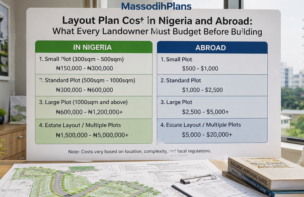
- Layout Plan Cost in Nigeria and Abroad: What Every Landowner Must Budget Before Building
- Smart Ways to Reduce Building Costs in Nigeria Without Reducing Quality
- Cost of Blocks, Cement, Iron Rod and Roofing Sheets in Uyo: Real Prices From the Field Now
- Estate Development Cost Breakdown: What Developers Should Budget For
- Estate Layout Design Services for Property Developers in Nigeria
- What Is a Master Plan and Why Does Every Growing Community Need One?
- How to Design an Estate Layout Plan That Works in Nigeria and Abroad
- How Much Does It Cost to Develop an Estate in Nigeria? A Town Planner’s Honest Breakdown
- Why Local Development Plans Matter for Communities
- Cost of Building a 4 Bedroom Duplex in Lagos (Complete Guide)
- Current Cost of Building a House in Port Harcourt (Professional Analysis)
- Nigerian Estate Master Plan for Small Plots: Modern Residential Layout Strategies That Maximize Space
- Site plan definition