Your City Is Suffering Because Nobody Did This: District Planning Explained
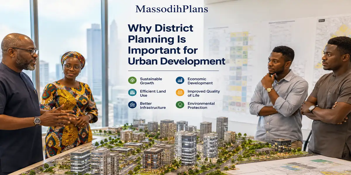
Why District Planning Is Important for Urban Development
A Plain-Language Guide for Nigerians, Governments, and Anyone Who Cares About How Their City Grows
The Answer You Came Here For
District planning is important for urban development because it creates order where chaos would otherwise take over. It tells every piece of land what it is for. It decides where roads go, where water drains, where schools and clinics are built, and how far a building must sit from its boundary. Without district planning, a city grows the way a market grows without a market master randomly, noisily, expensively, and with enormous suffering for the people who live in it.
That is the short answer. But if you want to truly understand why district planning matters and I mean understand it at the level where you can see it with your own eyes in any Nigerian city or town then stay with me. Because what I am about to share comes from 15 years of working as a registered Town Planner and Architectural Designer across multiple Nigerian states, not from a search engine or a textbook summary.
I have walked unplanned settlements at 6am when flood water was still draining from shops. And I have reviewed development applications where people built three-storey structures with zero setbacks. I have sat across the table from government officials trying to work out how to fix a district that nobody planned properly 30 years ago. District planning is not an abstract concept to me. It is a daily reality.
From what I have seen in practice, the difference between a functioning urban area and a dysfunctional one is almost always traceable to whether district planning was done properly at the start or whether nobody bothered at all.
What Is District Planning and How Is It Different from a Master Plan?
Many people confuse district planning with master planning. They are related but not the same thing. Let me explain this clearly.
A master plan is the big picture. It covers an entire city, a state capital, or a large urban area and sets the long-term vision for how land should be used and how infrastructure should grow. Think of it as the city’s constitution.
A district plan is one level down. It takes a specific portion of the city, a defined district or neighbourhood, and provides detailed planning guidance for that area. It translates the broad intentions of the master plan into specific regulations, zones, road alignments, plot sizes, setbacks, land use designations, and infrastructure provisions that apply to every plot of land within that district.
During my undergraduate studies in Town Planning at the University of Uyo, one thing our lecturers constantly emphasized was this: a master plan without district plans is like a national budget without ministry-level allocations. The vision is there but nobody knows exactly what to do on the ground.
District planning answers the practical questions:
- What can this particular plot of land be used for?
- How tall can a building on this plot be?
- How far must the building sit from the road and from its neighbours?
- What happens to the drainage when it rains heavily in this area?
- Where is the nearest school, clinic, and market meant to be located?
- What road width is required on this street?
- What commercial activities are permitted or prohibited in this neighbourhood?
These are the questions that shape everyday life for millions of Nigerians. And district planning is what answers them.
The Nigerian Reality: What Happens to a City Without District Planning
I want to describe something to you. Not a hypothetical. A real thing that is happening in Nigerian cities right now.
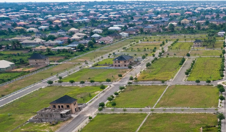
Imagine a neighbourhood that started as a residential area 25 years ago. A few decent houses were built. Roads were cleared, not properly designed, just cleared. People moved in. Then a mechanic workshop opened on one plot. And then a church started holding crusades on another. Then a poultry farm appeared three plots away from a primary school. A market started under a flyover. Drainage channels were blocked to create parking spaces.
Today, that neighbourhood has:
- Roads too narrow for two cars to pass each other comfortably
- Flooding every rainy season because the drainage channels no longer exist
- Children walking past generator fumes and open sewage to reach school
- Property values that have barely moved in 15 years
- Businesses that cannot grow because logistics are impossible
- Emergency vehicles that cannot reach houses deep inside the area
This is not a fictional place. I have seen this issue firsthand across Uyo, Port Harcourt, Owerri, Onitsha, and many other Nigerian urban areas. And the root cause is almost always the same: nobody prepared a district plan. Or a plan was prepared but never enforced.
This is what unplanned urban development looks like after 20 to 30 years. And it is extremely expensive to fix. Urban renewal projects cost far more than district planning would have cost in the first place.
One lesson I learned early is that Nigerian cities are not poor because their people are poor. Many of them are struggling economically because the physical environment makes economic activity inefficient, dangerous, and costly. District planning is one of the most powerful economic tools a government can use. Most Nigerian governments have simply not used it.
Land Use Distribution: The Foundation of Every District Plan
The most fundamental thing a district plan does is decide what each piece of land within the district will be used for. This is called land use distribution or land use zoning.
At the University of Uyo, we were taught that land use distribution is not just about putting activities in boxes. It is about understanding how land uses interact with each other, which combinations create value and functionality, and which combinations create conflict and degradation.
Standard Land Use Categories in a Nigerian District Plan
- Residential: Where people live. Further divided into low-density (large plots, detached houses), medium-density (semi-detached, terraced), and high-density (flats, face-me-I-face-you, social housing).
- Commercial: Where goods and services are bought and sold. Divided by scale and intensity, from neighbourhood shops to major commercial centres.
- Industrial: Where goods are manufactured or processed. Light industry and heavy industry carry different standards and separation requirements.
- Institutional: Schools, hospitals, churches, government offices, police stations. These are public and semi-public uses that require careful location planning.
- Recreational: Parks, playgrounds, sports facilities, open spaces. Often the first thing deleted from plans under pressure to create more plots. Always a mistake.
- Transportation: Roads, car parks, bus terminals, railway corridors. The movement network that connects everything else.
- Agricultural and Environmental Reserve: Farmland, forest reserves, floodplains, wetlands. Areas that must be protected from development.
In my experience, most planning failures in Nigerian urban areas can be traced to one of two problems: either land use distribution was never done, so everything is mixed together without logic, or it was done on paper but never enforced, so encroachment turned residential areas into commercial ones and open spaces into buildings.
Zoning Hierarchy: How District Plans Create Order From Complexity
Zoning is the system by which a district plan assigns specific land use regulations to specific geographic areas. It is one of the most powerful tools in urban planning and one of the most commonly misunderstood.
Many people assume that zoning is just about labelling areas on a map, but my experience suggests otherwise. Zoning is a legally binding system of rights and restrictions. When a plot is zoned residential, the owner has the right to build a house and the legal obligation not to build a factory. When a plot is zoned commercial, specific height limits, setbacks, and use types apply. These are enforceable requirements, not suggestions.
The Zoning Hierarchy in Nigerian District Planning
- Primary Zoning: The main land use designation for each area. Residential, commercial, industrial, institutional, recreational. This is the big picture layer.
- Secondary Zoning: Sub-categories within each primary zone. Low-density residential versus high-density residential. Light commercial versus heavy commercial. These apply different development standards.
- Overlay Zoning: Special regulations that apply to specific areas regardless of the primary zone. Flood hazard overlay, heritage overlay, noise control overlay, environmental sensitive area overlay.
- Special Use Zones: Areas with unique requirements that standard zones cannot accommodate. Industrial parks, technology zones, waterfront development areas, airport approach zones.
During my internship, I observed that the absence of clear zoning hierarchies in Nigerian urban areas was one of the primary reasons development control was so difficult to enforce. When there is no clear designation for a piece of land, an enforcement officer has no legal basis to stop inappropriate development.
Zoning gives the law its teeth.
Road Hierarchy and Circulation Systems: How People and Goods Move Through a District
A district without a functioning road hierarchy is like a human body without a circulatory system. Everything slows down, congestion builds up, and eventually the whole thing starts to fail.
I first learned this concept while studying Town Planning, but I truly understood it the first time I stood in traffic in an unplanned Nigerian neighbourhood and watched two hours disappear while trucks, keke-napeps, okadas, and pedestrians competed for the same 6-metre strip of road.
The Road Hierarchy in a Properly Planned District
- Primary Arterial Roads: The main movement corridors connecting the district to the wider city. Typically 24 to 36 metres wide. High traffic volume, limited direct plot access, designed for speed and flow.
- Collector Roads: Secondary roads that gather traffic from residential and commercial streets and direct it to arterial roads. Typically 18 to 24 metres wide. Moderate speed, moderate access.
- Local Access Roads: Streets that give direct access to individual plots. Typically 9 to 15 metres wide depending on land use. Low speed, high access, pedestrian priority.
- Service Lanes and Rear Access Roads: Narrow lanes for utility access, refuse collection, and rear plot access. Typically 4.5 to 6 metres wide.
- Pedestrian Paths and Cycle Ways: Dedicated movement routes for people on foot or bicycle, separated from vehicle traffic. Critical for safety and often completely absent in Nigerian urban areas.
On a project I worked on in Akwa Ibom State, the original road layout had every road the same width: 7.5 metres. There was no hierarchy at all. Trucks delivering goods to the market were using the same roads as children walking to school. We redesigned the road hierarchy completely. The result was a measurably better-functioning environment once the roads were constructed.
Based on my experience, the safest approach when designing a district road network is to design for the heaviest vehicle that will use each road type and then add a buffer. In Nigeria, that means accounting for heavy-duty delivery trucks on collector roads, not just small cars.
Physical Planning Standards and Setbacks: The Rules That Protect People
Every district plan must specify physical planning standards. These are the measurable requirements that every building and development within the district must meet. They exist to protect people — from fire, from flooding, from loss of privacy, from dangerous structures, from incompatible neighbours.
This principle formed a major part of our coursework at the University of Uyo. Physical planning standards are not bureaucratic obstacles. They are the accumulated wisdom of generations of planners and engineers who learned, often through disasters, what happens when buildings are too close together, too tall for their foundations, or built in the wrong places.
Key Physical Planning Standards in Nigerian District Plans
- Building Setback from Road (Front Setback): The minimum distance between a building and the road boundary. Typically 3 to 9 metres for residential, 6 to 15 metres for commercial and industrial, depending on road class and state regulations.
- Side Setbacks: Minimum distance between a building and the side boundary of the plot. Typically 1.5 to 3 metres for residential, more for industrial uses.
- Rear Setback: Minimum distance between a building and the rear boundary. Typically 3 metres for single-storey residential, more for multi-storey.
- Maximum Plot Coverage: The percentage of the plot that can be covered by buildings. Typically 50 to 65 percent for residential, 60 to 75 percent for commercial.
- Maximum Building Height: Expressed in storeys or metres. Varies by zone and proximity to airports, power lines, and other sensitive infrastructure.
- Minimum Plot Size: The smallest plot that can be created through subdivision. Prevents over-crowding of land at the plot level.
I have seen this mistake repeatedly: developers who build right up to the plot boundary in all directions, leaving no setbacks at all. I understand the temptation. Every metre of setback is a metre you cannot build on. But I have also seen what happens when two buildings with no setbacks between them catch fire. Emergency vehicles cannot get close. Water cannot be directed effectively. The fire spreads. People die. Setbacks save lives.
Infrastructure Planning in District Development: The Systems Underneath Everything
District planning is not just about what sits on the ground. It is about what goes underneath it. The infrastructure systems water supply, drainage, sewage, power, telecommunications — must be planned before a single plot is sold or a single building is constructed.
In practical terms, what usually happens in unplanned Nigerian urban areas is that infrastructure is retrofitted after development has already occurred. And retrofitting infrastructure into a built-up area is enormously expensive, disruptive, and often impossible without demolishing buildings.
Water Supply Planning at District Level
A district plan must identify the source of water supply, whether public mains, boreholes, or a combination, and design the distribution network to reach every plot. This means:
- Identifying borehole sites that respect minimum distances from drains, septic systems, and waste dumps
- Designing distribution mains of adequate pipe diameter to serve the projected population
- Including fire hydrant provisions at regulated intervals
- Planning for water storage at community level to buffer against supply interruptions
Drainage Network Planning
Drainage is the infrastructure element most directly linked to flooding, disease, and quality of life in Nigerian urban areas. A district plan must include:
- A primary drainage network that collects all surface water and directs it safely to a natural watercourse or retention facility
- Secondary drains along every road and street
- Tertiary drains providing plot-level drainage connections
- Retention and detention facilities where land allows, to reduce peak runoff and flooding downstream
- Protection of natural drainage channels from encroachment, which is one of the most violated requirements in Nigerian urban areas
Power and Telecommunications Infrastructure
- Dedicated transformer allocation and substation sites identified in the district plan
- Electricity distribution corridor rights-of-way protected from building encroachment
- Underground cable routes designed into road reserves where possible
- Telecommunications mast sites pre-designated to avoid future land use conflicts
My internship experience reinforced the importance of planning infrastructure corridors before land is developed. Once buildings go up, relocating a power line or a drainage channel becomes a political, financial, and social nightmare.
Drainage Systems and Flood Control: The Most Urgent Issue in Nigerian District Planning
I want to be very direct about this. Flooding is one of the most destructive and most preventable problems in Nigerian urban areas. And it is preventable precisely through proper district planning.
This is not just theory. I have seen it happen. And I have visited commercial areas where traders were mopping flood water from their shops at 8am, having lost thousands of naira in stock overnight. I have seen residential estates where ground floor flats are uninhabitable every rainy season because the drainage was never designed. I have inspected sites where natural drainage channels were blocked by market structures and later caused catastrophic flooding.
What Flood Control Requires in District Planning
- Topographic Survey First: You cannot design drainage without knowing the natural contours of the land and the direction of water flow. Every district plan must be based on accurate topographic survey data.
- Floodplain Identification and Protection: Areas within a defined distance of rivers, streams, and drainage channels must be designated as floodplain reserves where building is prohibited or heavily restricted.
- Designed Drainage Network: Open drains, covered drains, underground pipes, and retention basins sized and located based on calculated rainfall intensity and catchment area.
- Floor Level Standards: All buildings in flood-risk areas must have their ground floor level set above the calculated 100-year flood level.
- Drainage Maintenance Access: Every drain must be accessible for cleaning and maintenance. Covered drains must have inspection chambers at regular intervals. This is consistently ignored in Nigerian developments until the drains block and flooding occurs.
One lesson I learned early and have confirmed many times since is that drainage maintenance is as important as drainage design. The best-designed drainage system in the world will fail if it is not regularly cleared of debris. District plans must include drainage maintenance provisions, not just drainage design.
Environmental Management: Protecting What Cannot Be Replaced
Every district plan must include an environmental management framework. This is not optional, and it is not just about regulatory compliance. It is about ensuring that the district remains a healthy, functional, and attractive place to live and work for generations.
My experience in planning and design has shown me that environmental management in district planning covers:
- Green space allocation and protection: Every district must set aside a minimum percentage, typically 10 to 15 percent in Nigerian planning standards, as parks, gardens, and open recreational space.
- Tree preservation and urban forestry: Existing trees of significant size or ecological value must be identified and protected. Urban heat in Nigerian cities is dramatically worsened by loss of tree cover.
- Wetland and watercourse protection: Natural water bodies and their surrounding buffer zones must be identified in the district plan and protected from development.
- Noise management: Zoning separation between noise-generating uses such as markets, workshops, and places of worship and residential areas is the primary tool.
- Waste management infrastructure: Designated waste collection points, transfer stations, and recycling facilities must be planned into the district from the beginning.
- Air quality management: Industrial zones must be located and buffered to prevent air pollution from affecting residential and institutional areas.
I did not learn this from a textbook alone. Working alongside experienced planners taught me that environmental quality is the single most consistent predictor of long-term property values in any district. Districts that protect their green spaces, manage their drainage, and control incompatible land uses consistently outperform those that sacrifice these elements for short-term plot yield.
Development Control: Turning Planning Into Reality
A district plan without development control is just a drawing. Development control is the administrative and legal system that ensures buildings and developments within the district actually conform to the plan.
During my internship, I observed that the weakest link in Nigerian urban planning is almost never the quality of the plan. It is the enforcement of the plan. Beautiful layouts sit in ministry filing cabinets while developers build whatever they want, wherever they want, with whatever dimensions they choose.
The Development Control Process in a Planned District
- Development Application: Anyone wishing to build within the district submits an application including drawings, structural calculations, and evidence of land ownership.
- Plan Review: The relevant authority, typically the state Ministry of Lands, Housing and Urban Development or a designated Urban Development Authority, reviews the application against the district plan standards.
- Site Inspection: Officers inspect the proposed site to verify the application information and check existing site conditions.
- Permit Issuance: If the application complies with the district plan, a development permit is issued.
- Construction Monitoring: Inspections during construction verify that building is proceeding in accordance with the approved plans.
- Completion Certification: A final inspection and completion certificate confirm that the building as constructed matches the approved design.
- Enforcement Action: Any development proceeding without approval or deviating from approved plans is subject to stop-work orders, fines, and demolition where necessary.
The evidence from projects I have worked on points to one consistent finding: development control works best when the district plan is clear, the regulations are simple enough to understand, and enforcement is consistent. It fails when the plan is vague, the regulations are complex and contradictory, and enforcement is selective or corrupt.
Population Projections and Planning for Future Growth
One thing that separates a properly prepared district plan from an amateur effort is population projection. A district plan must not only plan for the people who are there today. It must plan for the people who will be there in 20 or 30 years.
This principle formed a major part of our coursework. Population projection drives every infrastructure calculation: road capacity, water demand, drainage sizing, school and clinic provision, open space allocation, and more.
How Population Projections Work in District Planning
- Current Population Count: Derived from census data, household surveys, and field observation. The baseline from which all projections are made.
- Growth Rate Analysis: Using historical census data and regional growth trends to estimate how fast the district’s population will grow.
- 20-Year and 30-Year Projections: Standard planning horizons. Infrastructure is designed to the 20-year population, with expansion provisions for 30 years.
- Density Planning: Translating population projections into spatial density standards. How many people per hectare can the district’s infrastructure support?
- Service Provision Standards: Nigerian planning standards specify the population threshold that triggers each type of public facility: one primary school per 3,000 to 5,000 people, one health centre per 5,000 to 10,000 people, one market per 10,000 to 20,000 people.
In practice, what usually happens is that Nigerian urban areas grow much faster than their infrastructure was designed to serve. A district planned for 20,000 people may reach 80,000 in 15 years. If the district plan did not allow for this growth, the roads, schools, drainage, and utilities all become overloaded. The result is the overcrowded, underserviced urban areas we see across Nigeria.
Transportation Integration: Connecting the District to the City
No district exists in isolation. Every district plan must consider how the district connects to the broader urban transportation network, and what modes of transport its residents and workers will use.
In Nigeria, transportation integration in district planning must account for:
- Private vehicle access: Junction design, parking provision, and road capacity for car owners
- Commercial motorcycle and tricycle (okada and keke-napep) movement: These are the dominant urban transport modes in many Nigerian cities and must be accommodated safely, not ignored
- Minibus and bus access: Designated routes and stopping points for commercial buses serving the district
- Pedestrian movement: Safe, shaded walkways connecting residential areas to schools, markets, clinics, and transport stops
- Goods movement: Loading bays and truck access routes that do not conflict with residential traffic
A situation I encountered illustrates this perfectly. I reviewed a residential district plan where the sole road connection to the external road network was a single 9-metre road. Every resident, every delivery vehicle, every school bus, and every emergency vehicle had to use the same road. On school days and market days, the road was impassable. The plan had been approved without any analysis of transportation demand. It was an avoidable disaster.
GIS and Mapping Integration in Modern District Planning
My academic training exposed me to GIS (Geographic Information Systems) as a foundational tool in planning. In modern district planning, GIS is not a luxury. It is essential.
GIS allows planners to:
- Map the exact topography of the district and model drainage patterns
- Overlay existing land uses to identify conflicts and opportunities
- Analyse traffic flow and model the impact of new development
- Track infrastructure networks and identify gaps
- Monitor development control compliance over time
- Produce legally valid planning maps at accurate scales
- Assess environmental sensitivities including flood risk, erosion risk, and ecological value
I have worked with government planning offices that still operate entirely on hand-drawn maps and paper files. The quality of district planning that results from such approaches is predictably poor. Measurements are inaccurate. Boundaries are unclear. Disputes are frequent. Introducing GIS into the workflow transforms the quality and speed of planning.
This is something I believe every state Ministry of Lands and Urban Development in Nigeria should prioritise. The investment is not large. The returns in planning quality and dispute reduction are enormous.
Smart Growth Concepts: Planning Smarter, Not Just Bigger
Smart growth is a set of planning principles designed to ensure that urban areas grow efficiently, sustainably, and equitably. It is often discussed in Western planning contexts, but every principle is directly applicable to Nigerian urban development.
Over the years, I have noticed that Nigerian cities that have applied smart growth principles, even informally, have produced better urban environments than those that simply allowed growth to happen.
Smart Growth Principles for Nigerian District Planning
- Mixed-Use Development: Allowing residential, commercial, and institutional uses to coexist in the same district, even on the same street, reduces travel distances and makes communities more vibrant and self-sufficient.
- Compact Development: Higher density development in central areas, lower density at the periphery, reduces the length of infrastructure networks and makes services more affordable to provide.
- Transit-Oriented Development: Designing districts so that the highest-density development is concentrated around public transport nodes. In Nigerian cities, this means around motor parks, bus stops, and major road junctions.
- Preserving Open Space: Protecting parks, green buffers, and natural areas from development pressure. Urban open spaces provide economic, health, and environmental benefits that far exceed the value of the plots they occupy.
- Community Participation: Involving residents in the district planning process to ensure the plan reflects local needs and conditions. Communities that participate in planning are more likely to respect and enforce its provisions.
Both classroom learning and field experience support this conclusion: smart growth is not just an environmental preference. It is an economic strategy. Districts that apply smart growth principles cost less to service, retain their residents better, and generate more economic activity per square metre.
Mixed-Use Integration and Community Functionality
One of the most powerful things a district plan can do is create mixed-use areas where different activities support and complement each other rather than conflict.
The typical Nigerian approach to zoning has often been excessively rigid: pure residential here, pure commercial there, nothing mixed. The reality on the ground is often different. Nigerian communities are mixed by nature. People run small businesses from home. Artisans live next to teachers. Churches are neighbours to clinics.
The question is not whether mixing should be permitted. It is which combinations create value and which create problems.
Beneficial Mixed-Use Combinations in Nigerian Districts
- Ground floor commercial with upper floor residential: The most common and successful mixed-use typology in Nigerian urban areas. Ground floor shops generate income to support the residential development above.
- Neighbourhood-scale markets within residential areas: Small-scale retail serving daily needs, carefully located and designed to minimise noise, traffic, and waste impacts.
- Institutional uses such as schools and clinics within residential areas: These serve the residential population directly and create focal points for community life.
- Home-based small businesses in residential zones: Tailors, hairdressers, computer repair shops, tutors. These low-intensity commercial activities are compatible with residential use if properly managed.
Incompatible Combinations That District Plans Must Prevent
- Heavy industrial uses beside residential areas: Noise, fumes, heavy vehicle traffic, and safety hazards make this combination destructive.
- Abattoirs, auto workshops, and petrol stations adjacent to schools and residences
- Large-scale markets on narrow residential streets without adequate parking and loading facilities
- Religious buildings holding amplified events in densely residential areas without acoustic management
If I were advising a client or government official today, I would recommend adopting a mixed-use framework that is permissive for compatible uses and strict for incompatible ones. Blanket prohibition of mixing is both unrealistic and economically harmful in Nigerian urban contexts.
Open Space Allocation: The Asset Nobody Values Until It Is Gone
Open spaces are consistently the most sacrificed element in Nigerian district planning. When land pressure mounts, when plot yields need to increase, when budgets are tight, open spaces are the first thing removed from the plan.
I have seen this mistake repeatedly. And I have seen the consequences: districts where children have nowhere safe to play, where temperature is noticeably higher than surrounding areas because there are no trees, where flooding is worse because there are no detention ponds or permeable surfaces, where communities have no gathering point and social cohesion weakens.
Nigerian planning standards typically require a minimum of 10 percent of any district plan area to be allocated as open space. This is not generosity. It is a functional requirement.
- Parks and gardens reduce urban heat and improve air quality
- Playgrounds serve children’s health and development needs
- Sports facilities provide recreational outlets that reduce social problems
- Community squares and gathering spaces build social cohesion
- Green buffers between land uses reduce conflict and pollution
- Storm water gardens and retention ponds manage flood risk while providing amenity
From a planning perspective, I strongly recommend that any government or developer preparing a district plan resist the pressure to reduce open space allocation below the minimum standard. Those open spaces will be worth more to the community, and to property values, than the additional plots they replace.
Development Phases: How District Planning Enables Staged Implementation
One of the most practical benefits of district planning is that it enables a development to be implemented in phases without losing coherence. Without a plan, phased development tends to produce disconnected, poorly serviced fragments that never integrate properly.
With a district plan, each phase is designed as part of a complete picture:
- Phase 1 (Foundation Infrastructure): Roads, drainage network, utility main lines, perimeter works. The infrastructure that everything else depends on. Must be fully completed before any plot development begins.
- Phase 2 (Core Development): The highest-priority plots and facilities, typically those with the strongest demand or the most critical public function. Schools, clinics, main commercial centre, initial residential areas.
- Phase 3 (Expansion): Additional residential and commercial areas served by the Phase 1 infrastructure network, expanding outward from the established core.
- Phase 4 (Completion and Enhancement): Remaining plots, landscaping, additional public facilities, community amenities. This phase consolidates and improves the district.
A practical lesson from my internship was that phasing must be financially sequenced, not just physically sequenced. Phase 1 infrastructure must be funded before Phase 2 development begins. I have seen too many Nigerian developments where Phase 2 buildings went up before Phase 1 drainage was installed. The result was predictable: flooding, access problems, and angry plot owners.
What Good District Planning Means for Everyday Nigerians
Let me step away from the technical language for a moment and talk about what district planning actually means for the person living in a Nigerian neighbourhood.
It means your child can walk to school on a paved footpath without stepping into an open drain or being hit by a motorcycle.
And it means your shop does not flood every August when the rains come, because the drainage was planned to carry the water away from your street.
It means when someone in your family has a medical emergency at 2am, the ambulance can actually reach your house because the roads were designed wide enough and clearly enough for emergency vehicles to navigate.
Also it means you can open your window in the morning and not breathe generator fumes from the auto workshop that opened next door, because zoning separated that use from your residential area.
It means the park three streets away still exists because it was protected in the district plan, and your children have somewhere safe to play on weekends.
It means your property is worth more each year, not less, because the district is well-managed and attractive to newcomers.
I did not learn this from a textbook alone. I have seen both kinds of districts, and the difference in quality of life between them is stark. District planning is not a technical exercise. It is a human rights issue. Every Nigerian deserves to live in a planned, functional, healthy district.
Why District Planning Quality Directly Affects Your Returns
For investors, developers, and landowners, district planning quality has a direct and measurable effect on financial returns.
This conclusion is based on both academic training and real-world observation across 15 years of professional practice.
- Property values in well-planned districts consistently appreciate faster than those in unplanned areas. The difference can be 50 to 200 percent over a 10 to 15 year period in comparable Nigerian urban areas.
- Tenants pay premium rents in well-planned districts because the quality of the environment justifies the premium. Lower vacancy rates and lower tenant turnover increase income stability.
- Infrastructure costs are lower in planned districts because utilities, roads, and drainage were designed as integrated systems rather than retrofitted piecemeal.
- Government services are easier to extend to planned districts, meaning better water supply, power supply, and road maintenance from public authorities.
- Land disputes are less frequent in planned districts because boundaries, zones, and land uses are clearly defined and legally registered.
- Financing is more accessible for developments within approved planned districts. Banks and mortgage institutions prefer developments with complete planning approvals.
I have worked with clients who invested in plots within well-planned districts and with clients who invested in unplanned areas. After 10 years, the difference in returns is not marginal. It is transformational. The evidence from projects I have worked on points clearly: district planning quality is one of the highest-return investments a developer or a government can make.
Common Mistakes in District Planning: What to Avoid
Having seen this issue firsthand across Nigeria, I want to share the most common mistakes that undermine district planning and urban development.
- Preparing a plan and never enforcing it. This is the most common and most destructive failure. A plan that is not enforced is worse than no plan because it creates false confidence while development chaos continues.
- Reducing road widths to increase plot yield. Narrow roads create the congestion problems that reduce property values and economic productivity that the developer was trying to maximize in the first place.
- Deleting open spaces from the plan under land pressure. Open spaces are not surplus. They are functional infrastructure that has a measurable effect on property values, flood management, health, and quality of life.
- Planning without topographic survey data. Drainage cannot be designed without knowing the land’s natural slope and water flow. Skipping the survey creates flooding risk.
- Ignoring future population growth in infrastructure sizing. Roads and drains designed for 10,000 people will fail when 40,000 people arrive. Plan for the 20-year population minimum.
- Using unregistered practitioners. Only TOPREC-registered Town Planners can legally prepare and sign district plans and layout approvals in Nigeria. Using unregistered persons risks rejection and legal exposure.
- Allowing development to begin before infrastructure is in place. Phase 1 infrastructure must be completed before any plot development begins. No exceptions.
Planning Approval Process for District Plans in Nigeria
Understanding the approval process helps investors and developers plan their timelines and budgets accurately.
- Engage a TOPREC-Registered Town Planner: The professional responsible for the district plan preparation and statutory submission.
- Commission Surveys: Topographic survey by a SURCON-registered surveyor. This is the data foundation for the entire plan.
- Prepare the District Plan Document: Land use zoning, road network design, infrastructure framework, development control regulations, population projections, and environmental management plan.
- Submit to State Ministry of Lands and Urban Development: The formal submission for review and approval.
- Ministry Review and Public Notice: The plan is reviewed by technical officers and, in some states, published for public comment.
- Site Inspection: Ministry officers inspect the subject area to verify the plan against site conditions.
- Approval and Registration: The approved district plan is officially registered and serves as the legal development control framework for the area.
In my experience, district plan approvals take 3 to 18 months in most Nigerian states, depending on the completeness of the submission and the capacity of the approving authority. Engaging an experienced registered Town Planner who knows the specific state’s process significantly reduces approval time.
Frequently Asked Questions
What is the difference between a district plan and a master plan?
A master plan covers an entire city or large urban area with broad policy directions. A district plan covers a specific neighbourhood or district within the city with detailed regulations governing every plot of land, every road, and every infrastructure element. District plans translate master plan policy into actionable development standards.
Is district planning only for government?
No. Private developers, estate companies, and community associations can all commission district plans for areas they own or manage. A private estate developer preparing a layout plan for sale is essentially producing a district plan for that estate. The regulatory process applies to all.
What happens if a district is developed without a plan in Nigeria?
Without a district plan, there is no legal framework to guide or control development. Buildings go up without setbacks, roads are too narrow, drainage is ignored, incompatible land uses mix freely. The result is the dysfunctional urban areas common across Nigeria, expensive to fix and damaging to all who live in them.
How much does a district plan cost in Nigeria?
The cost depends on the size of the area, the complexity of the planning challenges, and the professionals engaged. A small residential district plan (10 to 50 hectares) typically costs N500,000 to N3,000,000 in professional fees, plus government approval fees and survey costs. Larger and more complex district plans cost significantly more. See our article on Commercial Development Planning Costs for a detailed breakdown.
Who can legally prepare a district plan in Nigeria?
Only Town Planners registered with the Town Planners Registration Council of Nigeria (TOPREC) can legally prepare and certify district plans and layout plans in Nigeria. TOPREC registration requires a qualifying degree in Town Planning and supervised professional experience.
How does district planning reduce flooding in Nigerian cities?
District planning reduces flooding by protecting natural drainage channels from encroachment, designing drainage networks sized for projected rainfall intensity, prohibiting building on floodplains, setting minimum floor level standards above flood lines, and allocating retention ponds and permeable open spaces that absorb runoff before it becomes flood volume.
Let me conclude by saying this: Districts Don’t Fail Accidentally. They Fail Without Planning.
If you have read this far, you now understand something that many Nigerian government officials, developers, and landowners do not: district planning is not a luxury or a bureaucratic formality. It is the foundation of every functional urban area on earth.
Every city you admire, whether in Nigeria or abroad, where roads work, flooding is managed, businesses thrive, and people live with dignity, was built on a foundation of careful district planning. And every city you have seen deteriorate into congestion, floods, slums, and dysfunction arrived there because planning was skipped, delayed, or ignored.
Nigeria can build better cities. Akwa Ibom can. Rivers State can. Lagos can. Every state has the knowledge, the professionals, and the regulatory framework. What is needed is the will to plan properly, the commitment to enforce the plan, and the patience to build infrastructure before buildings.
That is what MassodihPlans exists to support. Whether you are a government agency, a private developer, a community association, or an individual investor, we bring 15 years of field experience, formal Town Planning training, and genuine commitment to helping you build the right way.
If you need expert guidance on district planning, layout preparation, development control, or planning approvals in Akwa Ibom State or any other Nigerian state, contact MassodihPlans today. Let us plan it properly from the start so you never have to fix it expensively later.
About Author
Massodih Okon is a built environment professional with a background in architecture and urban planning. He specializes in practical Nigerian house design guidance through MassodihPlans.com.. He has a Master’s degree in Urban and Regional Planning, a first degree in Geography and Environmental Management, and professional certificates in Architectural Design, Landscape Design, and GIS. With over 15 years of hands‑on experience in architecture, town planning, GIS, and building economics across Nigerian residential and institutional projects, he understands the real challenges Nigerians face when planning and building homes.
At MassodihPlans, Massodih shares practical Nigerian building guides, modern bungalow and duplex house plans, and built environment resources created specifically for Nigerian homeowners, developers, and property investors. His work is based on real‑life conditions in Nigeria, climate‑responsive design, and cost‑effective planning, aimed at helping everyday Nigerians make smarter, more confident building decisions.
Explore More on MassodihPlans
- Read our guide on Commercial Development Planning Costs
- Browse the Plans Library for Nigerian house and estate plans
- Visit Plan School for free planning education
- Engage our professional planning and design services
- Read: What Is a Master Plan and Why Does Your City Need One
- Read: Building Approval Processes in Nigeria
- Read: Estate Layout Design Costs in Nigeria
- Small Residential Estate Layout Design in Nigeria: Smart Master Plan Ideas for Limited Land
- Layout Plan Cost in Nigeria and Abroad: What Every Landowner Must Budget Before Building
- Cost of Building a 4 Bedroom Duplex in Lagos (Complete Guide)
- Nigerian Estate Master Plan for Small Plots: Modern Residential Layout Strategies That Maximize Space
Reference: Town Planners Registration Council of Nigeria (TOPREC)