i Your Community Is Suffering Because Nobody Made a Plan for It

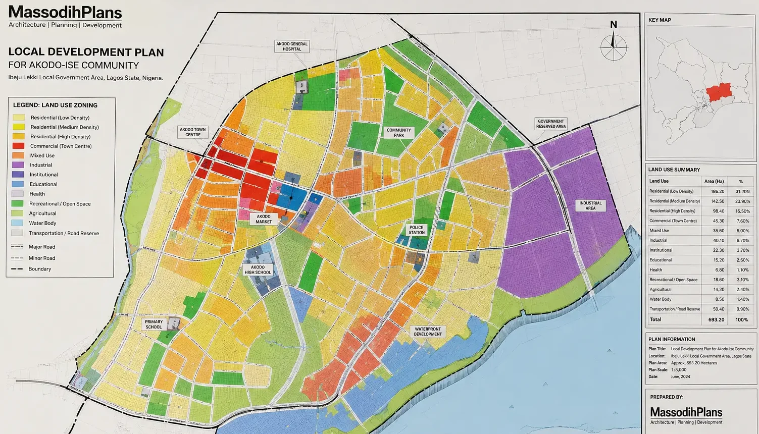
A properly prepared local development plan showing zoning districts, road hierarchy, drainage reserves, and public facility locations for a Nigerian urban community.
Look around your neighbourhood right now.
Are the roads narrow and always congested? Are buildings sitting right on top of each other with no breathing space? Is your street flooded every time it rains? And is a mechanic workshop next to a primary school? Is there a church, a market, and a factory all squeezed into the same residential street?
If you answered yes to any of those questions, your community is living with the consequences of having no proper local development plan. And the painful truth is that most communities in Nigeria and across the developing world are in exactly this situation.
As a Town Planner. I have spent over 15 years working on planning and design projects across Nigeria. What I am about to share with you is not a lecture. It is a direct explanation of why your community is the way it is, and what a proper local development plan would have prevented if anyone had bothered to prepare one before the buildings started going up.
What Is a Local Development Plan?
A local development plan, sometimes called a master plan or district plan, is a document that guides how a specific area of land should be used, developed, and managed over a defined period of time, usually 10 to 25 years.
Think of it as a blueprint for your community, the same way an architectural drawing is a blueprint for a house. Without the drawing, the builder guesses. Without a development plan, your community grows by accident.
The plan covers:
- Which land is for housing, and what type of housing
- Where roads should go, how wide they should be, and how they connect
- Where schools, hospitals, markets, and parks should be located
- Where industries and commercial activities are permitted
- How drainage and utilities will be provided
- What setbacks and building standards apply
- How the area will grow over time and in what direction
During my undergraduate studies in Town Planning at the University of Uyo, one thing our lecturers constantly emphasized was this: a settlement without a plan is not a community. It is just a collection of structures waiting for a crisis to happen.
The 15 Real Problems That Happen Without a Local Development Plan
I want to go through these carefully because each one is something I have personally encountered in the field. These are not textbook problems. They are the same things you are probably dealing with in your community right now.
1. Uncontrolled Urban Growth
When there is no plan, people build wherever they want, however they want. Buildings go up in drainage channels. Structures appear on public utility corridors. People encroach on government land because there are no visible boundaries. Before long, a planned neighbourhood has become a jumble of informal settlements, haphazard buildings, and structures that violate every standard there is.
In my experience, once a settlement starts growing without a plan, every year that passes makes the problem twice as expensive to fix. You cannot remove a market that has operated for 15 years without a serious social conflict. You cannot widen a road that has buildings on both sides without demolitions that cost more than the road itself.
2. Traffic and Transportation Chaos
Without a plan, roads are built by whoever builds them first. One person builds a fence. The next person builds a fence slightly further in. Before long, what should have been a 7-metre road has become a 3-metre path that two motorcycles can barely pass on at the same time.
I have seen this in virtually every unplanned settlement I have worked in. During field inspections as part of planning assignments, I discovered that some communities had no road wider than 4 metres in entire neighbourhoods of thousands of people. Emergency vehicles could not enter. Refuse trucks could not reach certain areas. And every morning was a traffic standstill.
3. Slum Formation and Poor Housing Quality
A slum does not start as a slum. It starts as a place where people build without guidance. One small structure becomes two. Two become twenty. By the time government notices, there are thousands of people living without clean water, without proper drainage, without toilets, in structures that a good rain can damage.
Many people assume that slums are the result of poverty alone, but my experience suggests otherwise. I have seen wealthy people living in what can only be described as slum conditions because their neighbourhood was never planned and has no infrastructure. Slums are primarily a planning failure, not just an economic one.
4. Land Use Conflicts
This is one of the most common problems I encounter in my professional practice. A factory next to a residential area. A bar beside a primary school. A filling station at the mouth of a cul-de-sac filled with family homes. These are not coincidences. They are the result of land use decisions that were never coordinated.
In one housing layout project I reviewed, an abattoir had been built by one of the early landowners, and years later, residential development had surrounded it on all sides. The community was living with the smell, the blood drainage, and the flies. No court order was easy to enforce because the abattoir had been there first.
A local development plan solves this by establishing a zoning hierarchy before the buildings go up. It says: this zone is for housing. This zone is for light commercial. This zone is for heavy industry. And you do not mix them.
5. Infrastructure Deficiencies
When a community grows without a plan, infrastructure always plays catch-up and usually loses. The water mains were sized for 500 people. Now there are 5,000. The transformer was sized for a village. Now it serves a small town. The road was built for occasional traffic. Now it carries daily market lorries.
From a planning perspective, the right approach is to project population growth, design infrastructure for the future population, and build in phases that are properly coordinated. This is what a local development plan does. It calculates future demand and makes provision for it before the crisis arrives.
6. Flooding and Drainage Failures
This is perhaps the most visually destructive consequence of poor planning that Nigerians are most familiar with. Every rainy season, communities that were never planned suffer floods that damage property, destroy roads, and in some cases kill people.
This is not just bad weather. This is bad planning.
In my experience working on site analysis and drainage assessments, most urban flooding in Nigeria is caused by three things: buildings constructed on natural drainage channels, absence of engineered drainage systems, and land surfaces that have been completely sealed with concrete and roofing without any provision for storm water management.
A local development plan identifies floodplains and reserves them as open space or park areas. It provides drainage reserves alongside roads. And it sets minimum floor levels for buildings. It calculates storm water runoff and designs drainage channels to handle it.
I have seen this principle illustrated clearly on projects I participated in. Two communities side by side. One with a layout plan that included proper drainage channels. One without. After heavy rain, the planned community had wet roads that drained within hours. The unplanned one had flooded houses for days.
7. Environmental Degradation
Trees disappear. Wetlands get filled. Rivers get blocked. Green spaces become building plots. This is the story of most rapidly growing Nigerian towns.
This is not just about aesthetics. Those trees were managing temperature, providing shade, absorbing carbon dioxide, and helping to regulate the water table. Those wetlands were natural flood buffers and biodiversity zones. When they are gone, the environmental cost is enormous and extremely difficult to reverse.
A local development plan sets aside green buffers, protects ecologically sensitive land, designates parks and open spaces, and ensures that development happens in a way that the natural environment can support.
8. Public Health Consequences
Poor planning kills people. It does not do it dramatically. It does it slowly, through contaminated groundwater from poorly sited septic tanks, through malaria from stagnant water in clogged drains, through respiratory illness from factory emissions in residential areas, through stress from overcrowding and lack of quiet spaces.
At the University of Uyo, we were taught that public health and urban planning were once the same discipline. Modern urban planning actually grew out of 19th-century efforts to prevent the spread of cholera and typhoid in rapidly industrialising European cities. The founders of planning were not architects. They were public health reformers who understood that how you arrange a settlement determines whether people in it live or die.
That lesson is still completely relevant in Nigeria today.
9. Economic Losses
Unplanned communities are economically inefficient. Roads are so bad that transport costs are higher than they should be. Congestion wastes productive hours. Business investors avoid areas with no infrastructure. Property values stay low because nobody wants to invest heavily in a neighbourhood that has no reliable utilities, no organised roads, and no legal clarity about land use.
I have worked with clients who wanted to develop commercial property in a certain area and withdrew when they saw that there was no road access beyond a certain point, no reliable power supply, and no drainage infrastructure. The investment went somewhere else. The community lost the jobs, the revenue, and the economic activity.
10. Social Problems and Crime
This is something I have observed directly during field work in unplanned communities. When there are no public gathering spaces, when there are no parks where children can play, when streets are dark and narrow and inaccessible, when there are corners and alleys that security cannot reach, crime finds those spaces.
Good urban planning is also crime prevention. A well-planned community has streets that are wide enough to be visible and well-lit. It has parks that attract people and therefore discourage criminal use. And it has a layout that emergency services can navigate quickly. It has an organisation that builds a sense of community and shared responsibility.
11. Disaster Vulnerability
When fire breaks out in a densely packed, unplanned settlement, it spreads rapidly because buildings are too close together, roads are too narrow for fire trucks, and there is no water supply point close enough to be useful.
When flooding comes, emergency responders cannot reach the affected areas because the roads are either underwater or were never wide enough for vehicles in the first place.
Both classroom learning and field experience support this conclusion: planned communities are fundamentally more resilient to disasters than unplanned ones. Not because disasters do not happen, but because the physical organisation of the settlement reduces vulnerability and improves the capacity to respond.
12. Governance and Land Administration Problems
Without a plan, government cannot manage land properly. Boundaries are disputed. Encroachments on public land happen constantly. Revenue from land-related charges is difficult to collect because there is no clear record of what is where and who owns what. Planning enforcement becomes nearly impossible because there is no approved standard to enforce against.
During my internship, I witnessed firsthand how development control officers in one local government spent most of their working time managing disputes and demolition orders that would simply not have existed if a proper layout plan had been prepared and enforced from the beginning.
13. Inadequate Public Facilities
In an unplanned community, public facilities are always playing catch-up and never quite catching up. Schools are overcrowded because nobody projected population growth and reserved land for future schools. The clinic is at the other end of town because nobody designated a central location for health facilities when land was cheap and available. There is no market in the residential core because it was never planned, so residents travel 3 kilometres to buy basic foodstuffs.
These are not complaints. They are planning failures. And they are completely preventable.
14. Security Blind Spots
An unplanned settlement has too many places that cannot be seen, reached, or monitored. Dark corners. Narrow alleys. Dead ends. Areas behind markets where no streetlight has ever been installed. Areas where even police vehicles cannot drive.
From a security planning perspective, the layout of a community is directly related to its security profile. A community planned with clear sight lines, wide enough roads for vehicle access, lighting provision, and defined public and private zones is a safer community.
15. Future Development Constraints
Perhaps the most expensive consequence of all. When you try to improve an unplanned community, every intervention costs enormously more than it would have cost to do it right from the beginning.
Widening a road means demolishing houses. Installing drainage means digging up finished compounds. Providing electricity requires routing cables through areas that were never designed with utility corridors in mind. Relocating a market that is in the wrong place means conflict with thousands of traders who have built their livelihoods there.
In my experience, it costs approximately three to five times more to upgrade an unplanned settlement to a reasonable standard than it would have cost to plan it properly from the start. The money that could have funded schools and hospitals goes instead to demolitions and compensations.
What a Local Development Plan Actually Contains
Let me walk you through the main components of a proper local development plan so you can understand what it really involves.
Land Use Zoning
This is the foundation. The plan divides the development area into zones, each with a defined purpose:
- Residential zones: Low density, medium density, high density
- Commercial zones: Neighbourhood commercial, district commercial, regional commercial
- Industrial zones: Light industrial, heavy industrial, warehousing
- Institutional zones: Education, health, government, religious
- Recreational zones: Parks, playgrounds, sports facilities, green buffers
- Special zones: Utilities, drainage reserves, road reserves
Each zone has specific development standards: plot sizes, building heights, setbacks, coverage ratios, permitted uses, and prohibited uses.
Road and Circulation Hierarchy
A well-designed road network follows a clear hierarchy:
- Primary roads (arterial roads): 20 to 30 metres wide. The main movement corridors. No direct plot access.
- Secondary roads (collector roads): 12 to 18 metres wide. Connect neighbourhoods to arterial roads.
- Tertiary roads (local roads): 9 to 12 metres wide. Direct access to plots.
- Service lanes: 6 metres wide. Rear access for servicing.
This hierarchy ensures that traffic is managed efficiently and that residential streets are not overwhelmed by through traffic from the wider road network.
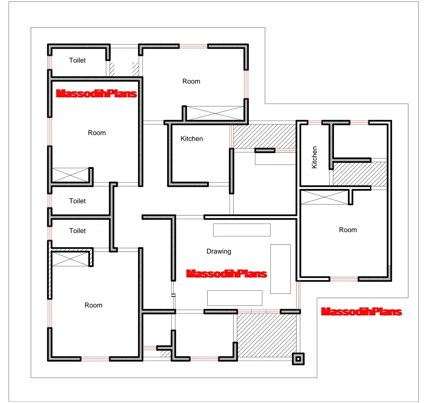
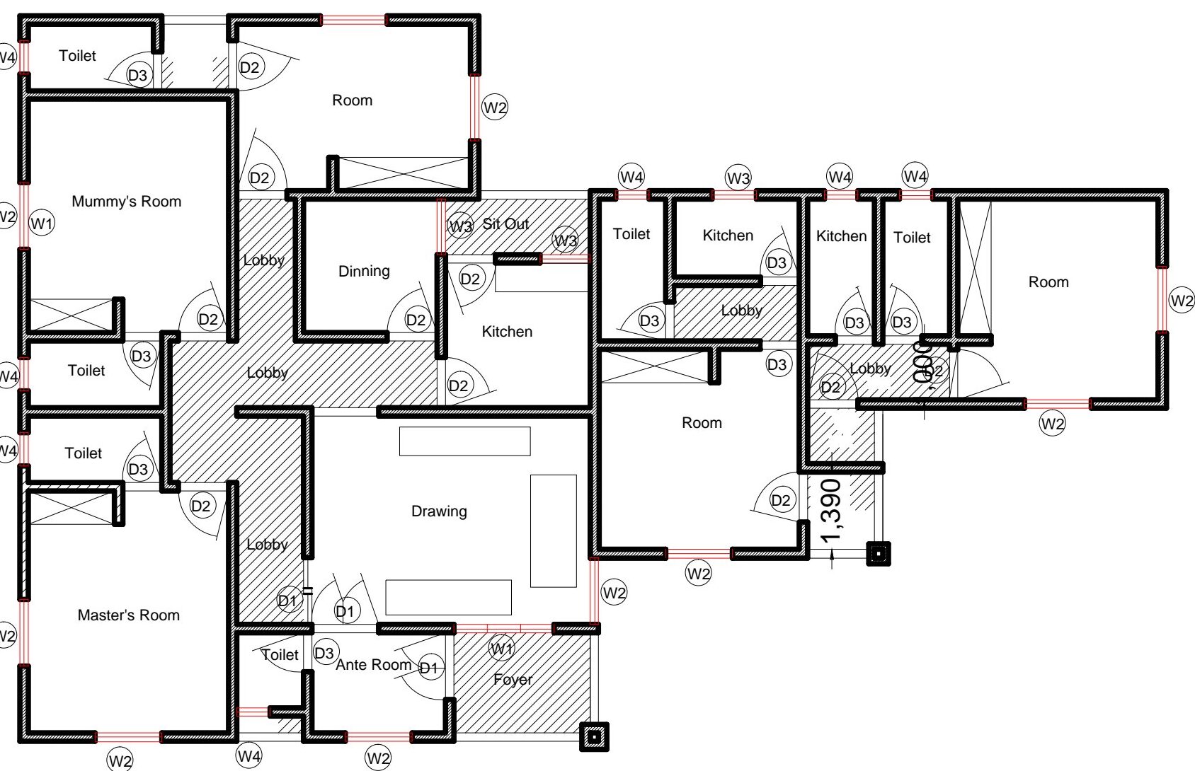
Plot Arrangement and Setbacks
Every plot in a planned layout has defined dimensions and setback requirements. Setbacks are the minimum distances a building must maintain from the plot boundary.
Typical residential setbacks in Nigerian planning standards:
| Position | Minimum Setback |
|---|---|
| Front (from road) | 3.0 to 4.5 metres |
| Side (each side) | 1.5 metres |
| Rear | 3.0 metres |
These setbacks are not bureaucratic obstacles. They are the spaces that allow light, ventilation, drainage, access for maintenance, fire escape, and future road widening. I have seen what happens when buildings are constructed right to the boundary line. Maintenance becomes impossible. Neighbours fight over shared walls. Every modification becomes a conflict.
Infrastructure and Utilities Planning
The plan reserves corridors for water mains, sewage lines, electricity cables, and telecommunications infrastructure. It identifies locations for substations, pump stations, water treatment facilities, and waste management sites. It ensures that these facilities are placed logically in relation to the areas they serve.
Drainage and Flood Control
The plan maps natural drainage patterns and designates drainage reserves along watercourses and road edges. It identifies floodplain boundaries and restricts development within them. And it specifies minimum floor levels for buildings in different zones. It designs a storm water management system that can handle projected rainfall intensity for the area.
This observation comes from practical field experience: The communities in Nigeria that flood most severely are almost always those where drainage reserves were either never designated or were subsequently encroached upon by development. The drainage channel that someone built their fence across 20 years ago is the reason water is now entering their house.
Open Space Allocation
A local development plan designates a minimum percentage of the total development area as open space. International planning standards recommend at least 10 to 15 percent of urban land as open and green space. This includes:
- Neighbourhood parks (within 400 metres of every house)
- District parks (within 1 kilometre)
- Playgrounds adjacent to primary schools
- Green buffers along roads and watercourses
- Civic squares at community focal points
Population Projections and Phasing
The plan calculates current and projected population, estimates land demand at different densities, and phases the release of development land to match population growth. This prevents the situation where all development happens at once in one area while other areas remain undeveloped, creating uneven infrastructure loads.
Development Control Standards
The plan establishes the regulatory framework that controls all future development. Plot coverage ratios. Building height limits. Parking standards. Signage regulations. Fence heights. Permitted and prohibited uses in each zone. These standards are then enforced through the building permit and planning approval process.
The Nigerian Reality Layer
I want to be direct with you about something that most planning textbooks do not say.
In Nigeria, many local development plans exist on paper but are never implemented. The plan was prepared, approved, printed, and filed. The settlement grew in a completely different direction. The reasons are familiar:
- Government agencies lack the capacity and funding to enforce the plan
- Political interference overrides planning decisions
- Land information systems are weak and do not reflect actual occupation
- Community members are not involved in the planning process and do not understand or respect the plan
- Plans are prepared without realistic assessment of implementation resources
In my experience, the best plans are not necessarily the most technically sophisticated ones. They are the ones that were prepared with real community involvement, that set achievable standards, that are supported by a realistic implementation framework, and that government has actually committed to enforcing.
GIS mapping has changed this significantly in recent years. When plans are backed by georeferenced data, satellite imagery, and digital boundary management, enforcement becomes more credible and disputes become easier to resolve. My academic training exposed me to the use of GIS in planning analysis, and both classroom learning and field experience support the conclusion that GIS-backed local plans are significantly more enforceable than paper-only documents.
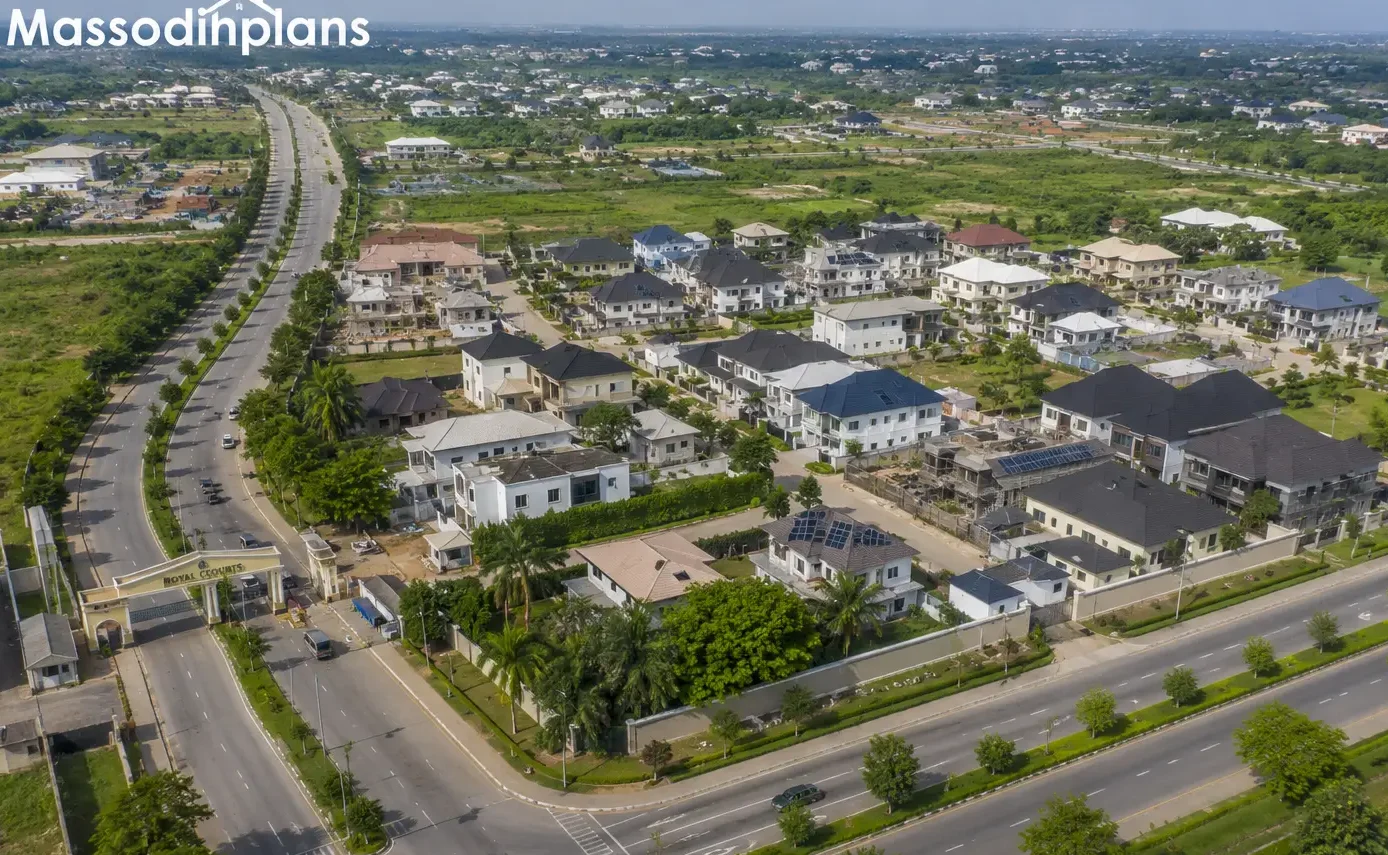
Investment Layer: Why Property Values Rise in Planned Communities
If you are an investor, a developer, or a homeowner thinking about where to put your money, this section is for you.
Properties in planned communities consistently command higher values than equivalent properties in unplanned ones. Here is why:
- Certainty: Buyers know what will be built next to them. A plan prevents a factory appearing beside a residence.
- Infrastructure: Planned communities have roads, drainage, and utilities that maintain property values over time.
- Legal clarity: Titles in planned layouts are easier to obtain and less likely to be disputed.
- Liveability: A well-planned neighbourhood attracts better-quality tenants and buyers.
- Investment confidence: Banks are more willing to lend against properties in areas with clear planning documentation.
I have worked with developers who deliberately target areas that have approved local development plans precisely because the investment risk is lower. The plan removes uncertainty. And in real estate, uncertainty is the enemy of value.
How Communities and Government Can Get This Right
Let me give you practical recommendations based on what actually works.
For government agencies and local planning authorities:
- Prepare local development plans before releasing land for development, not after
- Involve communities in the planning process from the beginning
- Use GIS and remote sensing to create accurate base maps before planning begins
- Set realistic development control standards that can actually be enforced
- Establish a development control unit with adequate staffing and resources
- Publish approved plans publicly so landowners and developers know the rules
- Review and update plans every 10 years or when major changes occur
And For community leaders and residents:
- Demand that your local government authority prepares or updates a local development plan for your area
- Participate in planning consultations when they are held
- Respect approved setbacks and building lines even before enforcement catches up
- Report encroachments on public land and drainage channels to relevant authorities
- Educate your neighbours about why planning standards exist
For developers and landowners:
- Always check whether an approved development plan exists for any land you want to build on
- Engage a registered town planner before designing your layout
- Do not encroach on road reserves, drainage channels, or public utility corridors
- Plan for infrastructure from the beginning, not as an afterthought
If you need guidance on getting building approval in Nigeria or understanding how development control works, our Plan School section covers the practical process step by step.
Frequently Asked Questions
What is the difference between a local development plan and a master plan?
In practice, the terms are often used interchangeably. A master plan typically refers to a broader strategic framework for an entire urban area or region, while a local development plan is usually more specific to a defined neighbourhood, district, or new development area. Both serve the same fundamental purpose: guiding how land is used and developed over time.
Who is responsible for preparing local development plans in Nigeria?
The responsibility sits primarily with State Urban and Regional Planning Boards, Local Government Planning Authorities, and in some cases the Ministry of Physical Planning at state level. In practice, private consultants (registered town planners and architects) are often engaged to prepare the actual plan documents, which are then reviewed, approved, and gazetted by the relevant government authority.
Can a local development plan be changed after it is approved?
Yes. Plans can be reviewed and amended through a formal process that typically involves public consultation, environmental assessment, and approval by the relevant planning authority. However, casual or politically motivated changes that contradict sound planning principles do enormous damage to community development and investment confidence.
Does every Nigerian community need a local development plan?
Every community that is growing or that is likely to attract development needs a plan. Rural settlements with stable populations may not require the same level of detail, but any area where land is being sold, buildings are being constructed, or infrastructure is being extended needs at minimum a layout plan and development control standards.
What happens if someone builds without respecting the local development plan?
The planning authority has the legal power to issue a stop-work order, require demolition or modification of the structure, refuse to issue a certificate of occupancy, and in some cases prosecute the developer. The challenge in Nigeria is consistent enforcement, which is why community awareness and demand for good governance are as important as the legal framework.
Further Reading
If this article helped you understand why planning matters, here are resources that will take your knowledge further:
- Understanding development control and building approvals in Nigeria
- What setbacks mean and why they matter for your building
- How to get a proper site plan prepared for your layout
- Modern residential layout design for Nigerian communities
- How drainage planning protects Nigerian homes from flooding
- Understanding land use zones in Nigerian towns
- How to plan a small plot for maximum value in Nigeria
- How GIS is changing town planning in Nigeria
- Our professional town planning and development services
Reference: UN-Habitat Urban Planning
Conclusion
Look at the most liveable, most functional, most economically active places in Nigeria and anywhere in the world. A planned layout is behind every one of them. The good roads did not appear by accident. The open spaces were not left because people were not greedy. The utilities work because somebody planned where they would go before the buildings came.
And look at the places that are drowning in traffic, flooding every rainy season, fighting over land, suffering from disease, and struggling to attract investment. A missing plan is behind most of that suffering too.
Local development plans are not bureaucratic paperwork. They are the difference between a community that works and one that barely survives.
The good news is that it is never too late to plan. Even for communities that have already developed without proper guidance, upgrading plans and development control frameworks can prevent further deterioration and begin the long process of improvement.
If you are a community leader, a government official, a developer, or simply a citizen who wants better for your neighbourhood, the message from this article is simple: demand a plan. Support a plan. Respect a plan.
And if you need professional help preparing a layout plan, development scheme, or planning proposal for your community or project, my team at MassodihPlans is equipped to deliver it.
Visit our Plan School to keep learning, or explore our Plans Library to see what well-planned residential environments look like in practice.
Your community deserves a plan. Make sure it gets one.
Written by Massodih | Town Planner | University of Uyo | 15 years of professional practice in Nigerian urban planning and design | MassodihPlans.com