If Your Town Has No Structure Plan: This Is What Happens Next

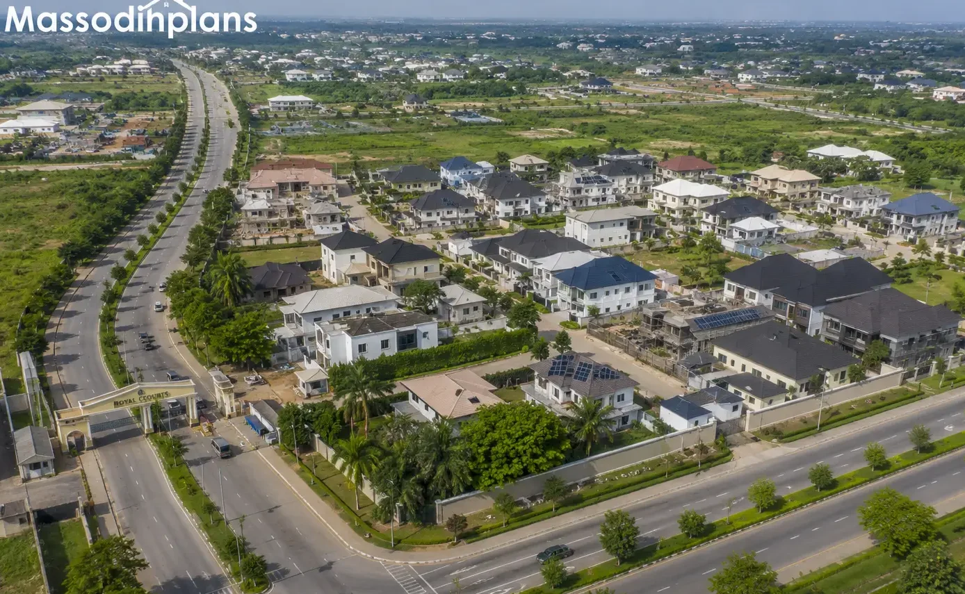
A planned Nigerian neighbourhood where setbacks, road widths, and land use zones are visibly organised the direct result of a working structure plan
What Is a Structure Plan and Why Is It Important?
If you have ever driven through a Nigerian town and felt like people threw everything together roads leading nowhere, markets sitting beside schools, houses blocking drains, and wires hanging dangerously low then you have seen a town operating without a working structure plan.
I have seen this firsthand, not just in textbooks. And I have encountered it during site visits, planning reviews, and client consultations. I have walked through neighborhoods in Akwa Ibom, Rivers State, and other parts of Nigeria where physical disorder had reached such a level that authorities and developers would spend ten times more to correct the problems than they would have spent to plan the area properly from the beginning.
That is exactly why this article matters. Not to impress you with big grammar. Not to fill space. But to genuinely explain what a structure plan is, what it does, and why the absence of one is silently destroying Nigerian towns, one unplanned building at a time.
Whether you are a student, a government official, a developer, a community leader, or just someone trying to understand why your neighborhood is the way it is, sit down. Let us talk about this properly.
What Is a Structure Plan?
A structure plan is an official planning document that sets out how land in a particular area should be used, developed, and managed over a defined period usually 15 to 25 years.
Think of it like a blueprint for an entire town or region. Just like you would not build a house without a drawing, a responsible government does not allow a city to grow without a structure plan.
It answers questions like:
- Where should residential areas go?
- Where should industries be located so they do not disturb homes?
- How wide should the roads be?
- Where should schools, hospitals, and markets be placed?
- How should drainage and flood control be handled?
- How do we manage growth as the population increases?
At the University of Uyo, one thing our lecturers constantly emphasized was that a structure plan is not just a map. It is a policy statement, a land use guide, and a development management tool all in one document.
Structure Plan vs Master Plan: Are They the Same Thing?
Many people use both terms interchangeably, but they are slightly different.
A master plan is typically more detailed and site-specific. It covers a defined area and provides precise layouts, plot sizes, road widths, building setbacks, and zoning details.
A structure plan is more strategic. It covers a larger area often an entire local government or urban region — and focuses on broad land use patterns, infrastructure corridors, and long-term growth directions. It provides the policy framework within which more detailed layout plans are prepared.
In Nigeria, both are used depending on the scale of the project. For a full town, a structure plan comes first. For a specific estate or housing scheme, a master plan follows.
From what I have seen in practice, many local governments in Nigeria jump straight to detailed layouts without first preparing a proper structure plan. That is one reason why you find estate roads that do not connect to main roads, and residential areas with no room for schools or clinics.
Why Does a Structure Plan Matter? The Real Answer.
Let me be honest with you. A structure plan matters because human beings need order to thrive.
When people are allowed to build anywhere without a plan, what looks like freedom quickly becomes suffering. You end up with:
- Houses built on drainage channels
- Markets expanding onto school land
- Roads too narrow for ambulances
- Areas where criminals hide because no street lighting or access was ever planned
- Floods destroying homes that should never have been built in flood zones
I did not learn this from a textbook alone. During my internship, I observed firsthand how communities in unplanned areas were struggling with flooding during every rainy season not because the rain was unusual, but because buildings had blocked natural drainage paths that existed long before the houses were there.
A structure plan prevents this. It creates order before chaos arrives, not after.
What a Structure Plan Contains: The Core Components
1. Land Use Distribution
This is the foundation of any structure plan. It decides which areas are for:
- Residential use: where people live
- Commercial use: markets, shops, offices
- Industrial use: factories, workshops, warehouses
- Institutional use: schools, hospitals, government buildings
- Open space and recreation: parks, playgrounds, green buffers
- Agricultural use: farming zones on the urban fringe
In one housing layout project I worked on, we had to completely relocate a proposed market because it had been placed too close to a school zone. Nobody had checked the compatibility of uses. A good structure plan handles this from the beginning.
The key rule is compatibility. You do not put a sawmill next to a primary school. You do not put a filling station inside a residential cluster without proper setback and buffer. These decisions are made at the structure plan level.
2. Zoning and the Zoning Hierarchy
Zoning is how a structure plan separates different land uses into distinct areas. Each zone has its own rules about what can be built, how high buildings can go, what activities are allowed, and what setbacks are required.
The typical zoning hierarchy in Nigerian town planning follows this pattern:
- Zone 1 (R1): Low-density residential — detached bungalows on large plots
- Zone 2 (R2): Medium-density residential — semi-detached and terrace housing
- Zone 3 (R3): High-density residential — flats and apartments
- Zone C1: Neighbourhood commercial — small shops serving a community
- Zone C2: General commercial — larger retail, offices, services
- Zone I: Industrial — light, medium, or heavy industry
- Zone IN: Institutional — schools, hospitals, government
- Zone O: Open space — parks, playing fields, green areas
During my undergraduate studies in Town Planning, we spent considerable studio time working with zoning maps. One lesson I learned early is that the zone boundaries are not just lines on paper. They represent real decisions about who lives where, what activities happen where, and how different land uses relate to each other.
If those lines are drawn carelessly or not drawn at all the result is the mixed-up, conflict-ridden neighborhoods many Nigerians live in today.
3. Road Hierarchy and Circulation Systems
A structure plan defines how movement happens across a town. Not just where roads go, but how they relate to each other in a system.
The standard road hierarchy used in Nigerian planning is:
| Road Type | Width (ROW) | Function |
|---|---|---|
| Primary Arterial Road | 30–50m | Main urban throughway |
| Secondary Road | 18–24m | Connects zones |
| Collector Road | 12–18m | Feeds into secondary roads |
| Access/Service Road | 6–9m | Serves individual plots |
| Pedestrian Path | 2–4m | For foot traffic only |
Over the years, I have noticed that many Nigerian developers design estate roads at 6m without any pedestrian setback. When two cars meet, one must reverse. And when an ambulance arrives, people have to move furniture. When a child walks to school, they walk in the road because there is no footpath.
This is not just inconvenient. It is dangerous. And it is entirely preventable with a proper structure plan that enforces road hierarchy from the start.
4. Plot Arrangement and Physical Planning Standards
A structure plan guides how plots are sized, arranged, and oriented across different zones.
Common plot size standards used in Nigeria include:
- Low-density residential: 600–900 sqm per plot
- Medium-density residential: 300–600 sqm per plot
- High-density residential: 150–300 sqm per plot
- Commercial plots: 300–500 sqm, depending on location
- Industrial plots: 1,000 sqm and above
Beyond size, plot arrangement matters enormously. Plots should be oriented to allow natural ventilation and light. Corner plots need wider setbacks. Back-to-back arrangements need service lanes.
On a project I worked on in Uyo, we redesigned the plot layout three times because the original arrangement left no room for compound walls without encroaching on the access road. These are the kinds of practical problems that proper planning standards prevent.
5. Setbacks and Open Space Allocation
Setbacks are the required distances between a building and the plot boundaries, roads, or neighbouring structures.
Typical setback standards in Nigerian planning:
| Building Type | Front Setback | Side Setback | Rear Setback |
|---|---|---|---|
| Bungalow | 3–6m | 1.5–3m | 3–4.5m |
| Duplex | 4.5–6m | 2–3m | 3–4.5m |
| Block of flats | 6m | 3m | 4.5–6m |
| Commercial building | 3–4.5m | 1.5m | 3m |
Many people assume setbacks are just bureaucratic requirements. My experience suggests otherwise. Setbacks provide ventilation between buildings, prevent fire from spreading, allow access for maintenance and emergency vehicles, and preserve the visual quality of a neighborhood.
I have seen cases where people ignored setbacks completely, and what seemed like a minor infringement later created major problems when a neighbor tried to build and discovered there was no legal space to do so. Land disputes emerged. Court cases started. The situation disrupted lives. All because nobody enforced the setback provisions of the plan.
Open space allocation is equally important. A structure plan reserves land for parks, community gardens, children’s play areas, and public squares. In Nigeria, people frequently ignore these allocations or sell them off. The result is neighborhoods with no green lungs, no gathering places, and no breathing room.
6. Infrastructure Planning and Utilities
A structure plan is not just about land. It is about the systems that make land livable.
This includes:
- Water supply: Reservoirs, treatment plants, distribution mains, service connections
- Electricity: Sub-stations, high-tension corridors, distribution networks
- Sewage: Treatment plants, collection networks, septic management zones
- Solid waste: Collection routes, transfer stations, designated disposal sites
- Telecommunications: Duct corridors for fiber and cable infrastructure
During studio exercises at university, our lecturers taught us to plan infrastructure before development begins, not retrofit it after buildings already stand. This principle formed a major part of our coursework.
In practice, Nigeria often follows the opposite approach. Developers build first. Infrastructure struggles to catch up later. Because buildings already occupy the available space, utility providers lay services under stairs, along walls, and across rooftops instead of within properly designated corridors.
The cost of this mistake is enormous. Both financially and in terms of human suffering.
7. Drainage Systems and Flood Control
This section alone could save thousands of Nigerian lives and billions of naira in property damage every year.
A structure plan must identify:
- Natural drainage channels: valleys, streams, seasonal waterways and protect them from encroachment
- Constructed drainage corridors: open channels, culverts, underground pipes
- Flood-prone zones: areas where buildings should be restricted or elevated
- Retention and detention ponds: where excess stormwater can be held during heavy rainfall
- Drainage easements: cleared strips along channels that must not be blocked
This is not just theory. I have seen it happen. A community I assessed in Akwa Ibom was experiencing flooding every rainy season not because the area was naturally flood-prone, but because a developer had built a boundary wall directly across a natural drainage path. The water had nowhere to go except into people’s homes.
A structure plan with properly defined drainage corridors and development restrictions would have prevented that wall from being built in that location.
8. Environmental Management
A forward-looking structure plan addresses the environmental dimension of urban growth. This includes:
- Green buffers around industrial zones to reduce pollution impact on residential areas
- Tree planting corridors along major roads to improve air quality and provide shade
- Wetland protection zones that prevent development on ecologically sensitive land
- Noise control buffers around airports, train lines, and heavy industries
- Environmental Impact Assessment (EIA) requirements for large developments
My experience in planning and design has shown me that environmental management provisions in structure plans are often treated as optional extras by developers. They are not. They are the difference between a livable city and an ecological disaster zone.
9. Urban Growth Strategy and Population Projections
A structure plan is built around a projection of how the population will grow over its planning horizon. This informs everything else.
The process typically involves:
- Base year population count using census data or household surveys
- Growth rate projection using historical data, migration trends, and economic forecasts
- Target year population estimate what will the area’s population be in 15–25 years?
- Land area requirement based on population density standards, how much land will be needed for housing, services, and employment?
- Phased development strategy which areas are developed first, and in what sequence?
At the University of Uyo, we were taught to prepare population projection tables as part of every planning report. One thing our lecturers constantly emphasized was that you cannot plan space without understanding who will occupy it and how many of them there will be.
A structure plan that ignores population dynamics will be obsolete before the ink dries.
10. Development Phases
A good structure plan does not try to develop everything at once. It identifies phases:
- Phase 1 (Years 1–5): Core infrastructure, primary road network, institutional plots, initial residential zones
- Phase 2 (Years 5–10): Secondary residential expansion, commercial development, utilities extension
- Phase 3 (Years 10–20): Peripheral growth areas, industrial zones, long-term expansion corridors
Phasing allows governments to concentrate limited resources on priority areas, avoid premature development in areas not yet served by infrastructure, and maintain development control as the urban area expands.
11. Transportation Integration
Movement is life in a city. A structure plan that ignores transportation is a plan waiting to fail.
Transportation integration in a structure plan covers:
- Inter-modal hubs where bus stations, motorcycle parks, and pedestrian routes meet
- Mass transit corridors reserved lanes or rights-of-way for future bus rapid transit or rail
- Non-motorized transport cycling paths and pedestrian networks especially around schools and markets
- Parking standards how many parking spaces are required per type of building
- Freight routes designated corridors for heavy vehicles moving goods
Working alongside experienced planners during my early career taught me that transportation planning is always underestimated in Nigerian urban projects. The default assumption is: build the houses first, the roads will sort themselves out. They never do.
12. Development Control
Development control is the regulatory arm of the structure plan. It is how the plan is enforced in practice.
Development control provisions specify:
- What types of buildings are allowed in each zone
- What approvals are required before construction
- Who enforces compliance
- What penalties apply to violations
- How monitoring and inspection work
During my internship, I observed that the most carefully prepared plans failed in areas where development control was weak. Developers ignored setbacks. Markets spread into road reserves. Structures appeared overnight in flood zones. And because enforcement was inconsistent, the violations became normalized.
A structure plan without development control is like a law without police. It may exist on paper, but it does nothing on the ground.
The Nigerian Reality Layer: What Actually Happens Without a Structure Plan
Let me stop being textbook for a moment and talk to you directly.
In most Nigerian towns, the following is the daily reality:
Roads: The main roads were designed in the colonial era for populations ten times smaller than today. Nobody widened them. Nobody planned alternatives. So every morning, people sit in traffic for two hours to travel five kilometers.
Drainage: Developers built over natural drainage channels. Contractors threw construction waste into open drains. Communities used drainage channels as dumpsites. And every July and August, the floods arrive like clockwork, drowning homes, destroying cars, and killing people.
Housing: Landlords subdivided plots into micro-units. Buildings share walls. Light cannot enter. Air cannot circulate. Tuberculosis, malaria, and other diseases spread easily in these overcrowded, unventilated spaces.
Markets: Markets grew wherever people decided to sell. Nobody asked whether the road could handle the additional traffic, or whether the drainage system could cope with market waste. Now the markets are permanent fixtures in completely unsuitable locations, and nobody has the political will to move them.
Land use conflicts: Churches with loudspeakers built beside hospitals. Welding workshops beside kindergartens. Abattoirs beside residential buildings. Every week, someone files a complaint. Every week, nothing changes.
This is the consequence of unplanned urban growth. And this is exactly what a structure plan is designed to prevent.
The Human Lifestyle Layer: What a Good Structure Plan Does for Ordinary Nigerians
A properly implemented structure plan changes real life in concrete ways.
It means:
- Your child can walk to school on a footpath, not in the road
- Your street has proper drainage that handles heavy rain without flooding your compound
- The market is located where it should be accessible but not blocking traffic
- Your neighborhood is quiet at night because industries are located in an industrial zone, not beside your bedroom
- When a fire breaks out or someone has a medical emergency, the road is wide enough for a fire truck or ambulance to reach you
- Your property value increases because the neighborhood is well-planned and well-maintained
- You can invest in your home confidently because zoning protects your area from incompatible development
Based on my experience, the neighborhoods in Nigeria with the highest property values and the most satisfied residents almost always started with proper structure plans, respected setbacks, and maintained their infrastructure over time
The Investment Layer: Why Investors Prefer Planned Areas
If you are thinking about property investment in Nigeria, here is something you need to understand clearly.
Investors, local and foreign look at structure plans before committing money. They want to know:
- Is this area properly zoned?
- Is there road access and drainage infrastructure?
- Are setbacks being enforced?
- Is there a development control framework?
- Is the area at flood risk?
- What is the long-term land use direction?
Areas with clear, well-implemented structure plans attract better investment. They generate higher land values. And hey get better access to commercial finance. They attract better businesses and more reliable tenants.
Areas without structure plans remain high-risk investments regardless of their strategic location. Developers and authorities face higher infrastructure costs because they fail to plan ahead. These areas experience more disputes and attract more legal complications.
If I were advising a client today, I would recommend investing only in areas with an existing structure plan and active development control. The risk premium in unplanned areas is simply too high.
GIS and Mapping in Structure Planning
Modern structure planning uses Geographic Information Systems (GIS) to produce accurate, data-driven plans.
GIS allows planners to:
- Map existing land use, vegetation, roads, and drainage
- Analyze slope and flood-risk zones with digital elevation models
- Overlay census and population data with spatial boundaries
- Model future growth scenarios based on different assumptions
- Produce precise zoning maps with coordinates linked to legal boundaries
My academic training exposed me to GIS analysis as a core planning tool. In practice, many Nigerian planning authorities still rely on outdated hand-drawn maps. This creates inaccuracies and disputes that GIS could easily resolve.
A serious structure planning effort in Nigeria today must integrate GIS from the data collection stage through to the final plan and the ongoing monitoring of implementation.
Smart Growth and Sustainability in Structure Planning
A modern structure plan does not just accommodate growth. It manages it intelligently.
Smart growth principles relevant to Nigerian urban planning include:
- Compact development building at higher densities in areas already served by infrastructure, rather than sprawling outward
- Mixed-use neighborhoods allowing compatible commercial and residential uses in the same zone, reducing travel distances
- Transit-oriented development concentrating higher densities along public transport corridors
- Green infrastructure using parks, street trees, and wetlands as functional infrastructure, not just decoration
- Climate-responsive design orienting buildings and roads to reduce heat islands, maximize natural ventilation, and minimize flood risk
This is not just environmental talk. This is money. Compact, well-planned cities cost less to service. Water pipes are shorter. Roads are more efficient. Emergency services reach people faster. Energy consumption is lower.
The evidence from projects I have worked on and planning literature I have studied consistently points in the same direction: sustainable urban form is also economically rational urban form.
The Planning Approval Process in Nigeria
For a structure plan to have legal force in Nigeria, it must go through a formal approval process. While this varies slightly by state, the typical process includes:
- Commissioning – the relevant government authority (state or local) commissions the plan.
- Data Collection and Analysis – planners conduct existing conditions surveys, population censuses, and infrastructure audits.
- Draft Plan Preparation – planners prepare the land use map, zoning regulations, infrastructure plan, and development standards.
- Public Participation – authorities display the draft plan and invite public comments (required under most state planning laws).
- Review and Revision – planners consider public comments and revise the plan accordingly.
- Formal Adoption – the relevant authority reviews and officially adopts the plan.
- Gazetting – the government publishes the plan in the official gazette, giving it legal status.
- Implementation – development control authorities enforce the adopted plan and guide development based on its provisions.
During my undergraduate studies, one thing our lecturers constantly emphasized was that public participation is not just a legal formality. It is how the plan gains community legitimacy. A plan that people did not contribute to is a plan people will resist.
Common Mistakes to Avoid in Structure Planning
These are real mistakes I have observed not theoretical ones:
- Ignoring existing informal settlements: A structure plan that pretends informal areas do not exist will fail to manage them
- Underestimating population growth: Plans that use conservative projections end up being obsolete within five years
- Poor land use compatibility analysis: Placing incompatible uses near each other because “there was space”
- No implementation mechanism: Preparing a beautiful plan with no budget, no enforcement, and no monitoring
- Ignoring drainage catchment areas: Planning within jurisdictional boundaries without considering how drainage works across those boundaries
- Selling or allocating open space reserves: The open spaces that were planned for parks end up being sold for development
- Inadequate road reserves: Roads planned too narrow for future widening
This is one of the most common misconceptions I encounter: that a plan is finished when the document is printed. The reality is that printing the plan is when the work truly begins.
Expert Notes: Key Principles That Rarely Fail
Based on projects I have worked on and both classroom learning and field experience, these planning principles hold true almost universally:
- Infrastructure before buildings: extend utilities first, then allow development to follow
- Protect natural drainage: never build on or across a natural waterway
- Enforce setbacks from the first building: violations compound over time
- Reserve land for future roads: once buildings occupy road reserves, widening becomes impossibly expensive
- Plan for the population that will arrive, not the one that is here today
- Connect to the larger system: local streets must connect to collector roads, which must connect to arterials
FAQs: Structure Plan in Nigeria
Q: Is a structure plan the same as a development plan?
A: A structure plan is one type of development plan. Other types include local plans, layout plans, and subject plans. A structure plan operates at a broader strategic level.
Q: Who prepares a structure plan in Nigeria?
A: State governments and local government authorities typically commission structure plans, while qualified town planners, architects, and related professionals prepare them. Private developers may also commission structure plans for large new developments.
Q: What law governs structure planning in Nigeria?
A: Structure planning is governed by state-level Urban and Regional Planning Laws. Many states have adopted laws modeled on the Nigerian Urban and Regional Planning Law (Decree No. 88 of 1992), though each state has its own specific provisions.
Q: How long does it take to prepare a structure plan?
A: A comprehensive structure plan typically takes 12 to 24 months from data collection to final adoption, depending on the complexity of the area and the resources available.
Q: Can a structure plan be revised?
A: Yes. Structure plans should be reviewed and revised every 5 to 10 years to respond to changes in population, economic conditions, and development patterns.
Q: What happens if someone builds against a structure plan?
A: In theory, development control authorities can issue stop-work orders, demand demolition, or prosecute offenders. In practice, enforcement in Nigeria varies significantly from one area to another.
Q: Does my house need to comply with a structure plan?
A: Yes. Any building development within a planning area must comply with the applicable structure plan and its zoning provisions, setback requirements, and development standards. This is part of the building approval process. Learn more about building approval on MassodihPlans.
Quick Summary: What a Structure Plan Does
| Function | What It Achieves |
|---|---|
| Land use zoning | Separates incompatible uses |
| Road hierarchy | Creates efficient movement |
| Plot standards | Ensures livable development |
| Setback enforcement | Protects health and safety |
| Infrastructure planning | Reduces provision costs |
| Drainage management | Prevents flooding |
| Environmental management | Protects natural systems |
| Population projection | Ensures adequate land supply |
| Development control | Prevents unauthorized building |
| Investment framework | Attracts quality development |
Finally: Build the Plan Before You Build the Town
I will end with something simple.
Every Nigerian town that is struggling today: the flooding, the traffic, the slums, the land disputes, the blocked drains almost none of it was inevitable. It was the result of decisions made or not made years ago. Decisions about whether to plan before building. And decisions about whether to enforce the plan after it was made. Decisions about whether to protect drainage channels, reserve road land, zone incompatible uses apart, and maintain open spaces.
A structure plan does not guarantee perfect urban development. Nothing does. But it gives you a fighting chance. It gives planners, developers, government officials, and communities a shared framework for making decisions that add up to a livable city rather than a chaotic one.
From a planning perspective, I strongly recommend that every Nigerian local government, every state planning authority, and every private developer working at scale invest in proper structure planning before allocating a single plot or issuing a single building permit
The cost of planning right now is a fraction of the cost of fixing it later.
If you are a student trying to understand this for an exam or a project, I hope this article gave you real clarity. If you are a developer or government official, I hope it helped you see why structure planning is not a bureaucratic inconvenience but a genuine service to the public.
And if you are just someone living in a badly planned neighborhood, wondering why things are the way they are now you know. And now you can start asking the right questions.
Browse related content on MassodihPlans:
- Understanding Urban Growth Problems in Nigeria
- How to Get Town Planning Approval in Nigeria
- House Plans for Small Plots in Nigeria
- Nigerian Building Setback Requirements
- Bungalow Plans for 50ft by 100ft Plots
- Duplex Plans for Nigerian Plots
- What Is a Master Plan? Nigerian Guide
- Urban Planning Services for Nigerian Developers
- Plan School: Learn Town Planning the Right Way
Reference: UN-Habitat Urban Planning Best Practices
About Author
Massodih Okon is a built environment professional with a background in architecture and urban planning. He specializes in practical Nigerian house design guidance through MassodihPlans.com.. He has a Master’s degree in Urban and Regional Planning, a first degree in Geography and Environmental Management, and professional certificates in Architectural Design, Landscape Design, and GIS. With over 15 years of hands‑on experience in architecture, town planning, GIS, and building economics across Nigerian residential and institutional projects, he understands the real challenges Nigerians face when planning and building homes.
At MassodihPlans, Massodih shares practical Nigerian building guides, modern bungalow and duplex house plans, and built environment resources created specifically for Nigerian homeowners, developers, and property investors. His work is based on real‑life conditions in Nigeria, climate‑responsive design, and cost‑effective planning, aimed at helping everyday Nigerians make smarter, more confident building decisions.