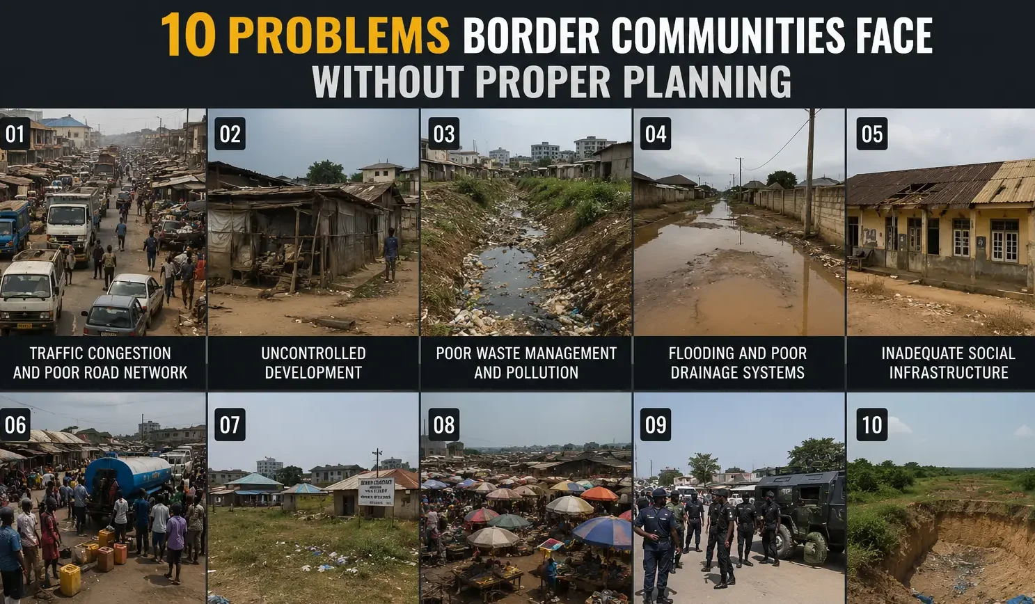

Narrow, poorly connected roads in unplanned communities create daily gridlock that affects productivity, emergency response, and quality of life
Introduction: The Price of Not Planning
Let me be honest with you from the very beginning.
I have walked through communities in Nigeria where there are no clear roads, no drainage, no order just buildings sitting wherever someone decided to drop them. No setbacks. And no road reserves. No space for a clinic, a school, or even a proper market. Just structure after structure, packed together like a puzzle someone threw on the floor.
And every time I walk through a place like that, one thought comes to my mind.
This did not have to be this way.
When a community grows without a proper town plan, master plan, or any form of structured physical planning, the consequences are not just inconvenient. They are generational. Children grow up in flood-prone settlements. Businesses collapse from poor access. Governments spend billions trying to fix what proper planning could have prevented for a fraction of the cost.
In this article, I want to take you through the ten most critical problems that border communities and indeed any settlement without proper planning face. I will not just list them. I will explain them the way I explain things to my students: with real examples, practical language, and the kind of honesty that only comes from actually working in this field.
Whether you are a homeowner, a student of town planning, a community leader, or a government official, this is the article you need to read before your community becomes another case study in what not to do.
Quick Note: This article focuses on unplanned or under-planned communities. If you want to see how a properly planned community looks from the beginning, see our guide to Master Plan Design and Estate Layout Planning.
First, What Is a Master Plan and Why Does It Matter?
Before we talk about problems, let me quickly explain what a master plan is.
A master plan is a long-term physical development framework that guides how a town, city, or community grows over time. It tells you where to build houses, where to put markets, where roads should go, where schools and hospitals must be located, and how to manage flooding, waste, and the environment.
In Nigeria, under the Urban and Regional Planning Law, every state is supposed to have a regional plan, every city a structure plan, and every neighbourhood a local plan. These plans come with zoning maps, land use allocations, road hierarchies, infrastructure layouts, and development control regulations.
But the reality on the ground, as I have seen many times, is that most communities especially border communities and rapidly growing peri-urban areas grow without any of these in place.
And when that happens, every single problem I am about to describe becomes inevitable.
Expert Note: A master plan is not just a drawing. It is a governance document. It tells a town planning authority what to approve, what to reject, and where infrastructure providers like power and water companies should extend their networks. Without it, everything becomes a guessing game.
Problem 1: Uncontrolled Urban Growth
This is where everything starts. And this is where everything goes wrong.
In my experience, the first sign that a community is growing without planning is the pattern of buildings. They do not follow any order. You see a residential building sitting right beside a mechanic workshop. And you see a mosque sharing a fence with a warehouse. You see a school on a narrow dead-end lane where trucks cannot even turn around.
This is what town planners call haphazard development, and it is one of the most stubborn problems to fix after it starts.
What Uncontrolled Growth Looks Like
- Buildings are constructed wherever land is available, without respecting setbacks, road reserves, or future infrastructure corridors
- Urban sprawl pushes the community outward, consuming farmland, green spaces, and buffer zones
- People encroach on public land: road reserves, drainage easements, and government-reserved areas
- Informal and illegal settlements form at the edges, occupied by people who cannot afford formal land
- Houses are built wall to wall with no breathing space, making future road widening or utility extension nearly impossible
During my undergraduate studies in Town Planning at the University of Uyo, one thing our lecturers constantly emphasized was that once haphazard development sets in, the cost of reversing it is almost always ten to twenty times the cost of planning it correctly from the start.
I did not fully understand what that meant until I started working on projects and saw communities where government had to demolish dozens of buildings just to create one access road.
That is not just wasteful. It is heartbreaking.
Nigerian Reality: In many border communities along major highways in states like Cross River, Akwa Ibom, Borno, and Niger, urban sprawl has consumed agricultural land and floodplains without any plan in place. By the time government tries to intervene, the community is already too dense to restructure without mass displacement.
Problem 2: Traffic and Transportation Nightmares
Show me an unplanned community and I will show you a traffic problem.
Roads in unplanned communities are usually organic meaning they follow the paths people created informally. These paths were never designed for vehicles. They were never laid out with a road hierarchy in mind. There are no arterial roads, no collector roads, no proper local streets. Just pathways that became lanes that became roads by accident.
The Transport Problems You Will Find
- Roads are narrow, sometimes less than four metres wide, making it impossible for two vehicles to pass each other
- Roads are poorly connected you can get into a neighbourhood but cannot get out easily
- Parking spaces are nonexistent, so vehicles park on the road, reducing the already narrow lanes
- Pedestrians walk on the same surface as vehicles because there are no footpaths or sidewalks
- Road accidents are more frequent because poor geometry creates blind corners and dangerous junctions
- Public transportation providers avoid the community because their buses cannot navigate the narrow lanes
In a properly planned community, road hierarchy works like this: major arterial roads connect to collector roads, which feed into local access roads, which serve individual plots. Every road has a standard width based on its function. Every junction is designed to handle traffic volume safely.
One lesson I learned early is that road reserves, once eaten into by buildings, are almost impossible to recover without demolitions. This is why physical planners fight so hard to protect road reserves during development control. Once you lose that land, you have lost the road forever.
Planning Principle: Nigerian road standards require arterial roads to be at least 30 to 40 metres wide, collector roads 20 metres, and local roads 12 to 15 metres. In unplanned communities, you rarely find any road wider than 6 metres.
Problem 3: Severe Housing Problems
Housing in an unplanned community is not just poor. It is dangerous.
When people build wherever they find land, without guidance from a development plan, you end up with settlements that are overcrowded, poorly ventilated, structurally unsafe, and completely lacking in basic services. This is how slums form.
And slums, once formed, are not just an aesthetic problem. They are a public health emergency, a security challenge, and an economic drag on the entire region.
The Housing Crisis in Unplanned Settlements
- Slum development: densely packed housing with no open space, poor sanitation, and deteriorating structures
- Overcrowding: too many people in too little space, sharing water points, toilets, and cooking areas
- Poor housing quality: buildings constructed without plans, without qualified engineers, without approved materials
- Incompatible land uses mixed into residential areas: a market beside a school, a fuel station next to a house
- Residents struggle to access basic services because roads are too narrow for delivery vehicles or emergency services
I have worked with clients in communities like this. One situation I encountered illustrates this perfectly. A family had built a home in a settlement that looked fine from the outside. But the building had no proper drainage, no access road wider than three metres, and was surrounded by commercial activities that generated noise, smoke, and waste. Their children could not sleep at night from the generators next door. They could not get a water tanker into their compound. They could not even sell the house because no bank would give a buyer a mortgage on a property in an unplanned area.
That family paid a very high price for planning they never had a say in.
Problem 4: Land Use Conflicts That Tear Communities Apart
This is one of the problems that most people do not see coming until it is too late.
Zoning, in town planning, is the practice of separating incompatible land uses. You keep industries away from homes. And you keep noisy markets away from schools and hospitals. You keep heavy commercial areas separate from quiet residential neighbourhoods. This is not about being rigid. It is about protecting the quality of life of residents.
Without a zoning plan, anybody can put anything anywhere. And that is exactly what happens in unplanned communities.
Land Use Conflicts in Action
- A welding workshop opens next to a nursery school. Children breathe metal fumes all day
- A poultry farm appears beside residential houses. The smell is unbearable
- A large mosque with a generator and a public address system is built next to residential buildings, creating noise conflicts
- Markets develop organically at road junctions, creating congestion that makes the entire neighbourhood inaccessible
- Fuel stations and mechanics workshops sit beside houses, creating fire and health hazards
- Commercial activities invade residential streets, turning family neighbourhoods into chaotic trading zones
My academic training exposed me to a concept called nuisance in planning law. A nuisance is when one land use negatively affects the enjoyment of another. In developed countries, this is dealt with through strict zoning enforcement. In unplanned communities across Nigeria and much of the developing world, nuisance is just called normal life.
But it does not have to be.
If you want to see how a proper zoning plan distributes land uses in a Nigerian estate, read our article on Estate Master Planning and Land Use Distribution.
Problem 5: Infrastructure That Cannot Keep Up
Infrastructure is expensive. Everyone knows that. But here is what most people do not know: infrastructure in an unplanned area costs significantly more to install than in a planned one.
Why? Because the layout is wrong. Pipes cannot run in straight lines. Power cables have to navigate around illegal structures. Water distribution points cannot be located where they will serve the most people efficiently. Every infrastructure provider ends up spending extra money to work around the mess that poor planning created.
Infrastructure Deficiencies in Unplanned Communities
- Water supply systems are inadequate or nonexistent because there was never a planned distribution network
- Drainage is poor because natural drainage channels were built over or blocked
- Electricity distribution is irregular because the layout does not allow for efficient transformer siting
- Sewage systems are absent, leading to open defecation and pit latrine overflow
- Utility extension becomes almost impossible without demolishing existing structures
During my internship, I observed that the biggest challenge infrastructure agencies face in unplanned areas is what engineers call the last mile problem. They can bring the main pipe or cable to the edge of the community. But the moment they try to extend it into the community, the organic layout makes routing almost impossible without conflict.
This is not just an engineering problem. It is a planning failure.
Investment Note: Properties in communities with good infrastructure are worth significantly more than those in unplanned areas. If you are thinking about where to build, see our MassodihPlans guide to choosing the right plot location for long-term investment.
Problem 6: Flooding and Drainage Disasters
I want to be very direct about this one.
In Nigeria, flooding kills people every year. Not because we do not have the engineering knowledge to prevent it. But because communities grow in floodplains, on drainage channels, and in low-lying areas that were never meant for human habitation.
When there is no master plan, nobody tells a developer: this land floods every rainy season, you cannot build here. Nobody enforces flood setbacks. Nobody protects natural drainage channels. And then the rains come.
Flooding Problems in Unplanned Communities
- Buildings are constructed directly on natural floodplains and seasonal water channels
- Drainage channels are blocked by structures, waste, and encroachments
- Urban flooding becomes a regular seasonal event, not an exception
- Erosion cuts into foundations and roads, causing structural damage
- The rainy season brings road destruction, property loss, and sometimes loss of life
This is not just theory. I have seen this happen. One challenge I repeatedly encountered during site analysis work was that residents themselves do not know their land is in a flood-prone zone because nobody ever told them. They bought the land, they built on it, and the first three years were fine. Then one October, the flood came and swept through.
Flood control in proper planning involves GIS mapping of drainage basins, identification of floodplains, setting of building setback lines from watercourses, and designing community-wide storm drainage systems. None of this happens without a plan.
Warning: If your community floods regularly during the rainy season, this is a strong sign of planning failure. Before building or investing in a flood-prone area, commission a proper site analysis. MassodihPlans offers site assessment and building feasibility advisory services.
Problem 7: Environmental Degradation
Here is a truth that most community leaders are not ready to hear.
Every time a tree is cut down to make way for an unplanned building, every time a wetland is filled to create land for a structure that should not be there, every time an open space is encroached upon the community loses a piece of its environmental protection.
Trees reduce heat. Wetlands absorb floodwater. Open spaces allow rainwater to infiltrate into the ground. These are not luxuries. They are the environmental infrastructure that keeps a community liveable.
Environmental Damage From Unplanned Growth
- Green spaces are consumed by development, leaving no parks, recreation areas, or natural buffers
- Deforestation removes natural windbreaks and canopy cover, raising local temperatures
- Wetland destruction eliminates natural flood buffers and water filtration systems
- Air pollution rises as industries, generators, and traffic concentrate in unplanned zones
- Water pollution increases as waste and sewage flow into streams and groundwater sources
- Noise pollution becomes constant and unmanaged
- Solid waste accumulates because there is no planned waste management system
From a planning perspective, I strongly recommend that any community development plan reserve a minimum of 10 to 15 percent of total land area for open spaces, green corridors, and environmental buffer zones. This is not just a planning standard. It is a survival strategy.
Problem 8: Public Health Crisis
An unplanned community is, at its core, a public health emergency waiting to happen.
Think about it. When drainage is poor, mosquitoes breed. And when sewage has nowhere to go, waterborne diseases spread. When solid waste is not managed, rodents multiply. Also when housing is overcrowded and ventilation is poor, airborne diseases transfer easily. When clean water is not provided, people drink from contaminated sources.
Every single one of these conditions is a direct consequence of planning failure.
Public Health Problems in Unplanned Communities
- Communicable diseases like malaria, typhoid, and cholera spread rapidly in unplanned dense settlements
- Sanitation is poor because there are no planned toilet facilities, waste disposal points, or sewage systems
- Solid waste accumulates along roads, in drainages, and in open spaces
- Water sources become contaminated by nearby latrines, waste dumps, and chemical runoff
- Mosquito breeding grounds multiply in stagnant water from blocked drains
I did not learn this from a textbook alone. Working alongside experienced planners taught me that communities with poor physical planning have significantly higher rates of preventable diseases. The link between spatial planning and public health is not academic. It is physical. It is visible. And it is tragic.
Problem 9: Economic Damage and Reduced Investment
Let me explain something that surprises a lot of people.
Investors look at planning. Banks look at planning. Businesses look at planning. Before anyone puts serious money into a community, they want to know: is this place organized? Is there a development framework? Can I get my goods in and out easily? Will the value of my investment grow or decline?
In an unplanned community, the answer to all of those questions is usually no.
Economic Challenges From Poor Planning
- Property values are lower because buyers know the area is unplanned and lacks services
- Infrastructure costs are higher, which makes businesses less competitive
- Investors avoid the area because poor access and incompatible neighbours reduce profitability
- Business efficiency is reduced by constant transportation delays and poor logistics
- Transportation costs are higher because roads are poor and routes are longer than necessary
- Overall economic productivity of the community is suppressed
Based on my experience, the safest approach for any family or investor is to prioritize location and planning status before committing funds to a property. A house in a well-planned estate with good roads, drainage, and services will always outperform an equivalent structure in an unplanned settlement — in value, in liveability, and in investment return.
Problem 10: Social Problems and Security Risks
This is the problem that affects ordinary people most directly every single day.
Unplanned communities create conditions where crime becomes easier, social cohesion breaks down, and people lose their sense of community. When there are no public spaces to gather, when streets are dark and inaccessible, when people do not know their neighbours because buildings are chaotic and boundaries are unclear — social problems follow.
Social and Security Problems
- Poor street lighting and dark alleyways create opportunities for crime
- Areas inaccessible to security vehicles allow criminal activity to go unchecked
- Social segregation occurs as wealthier residents leave unplanned areas for estates
- Poor community cohesion because there are no shared public spaces or gathering points
- Recreational facilities are nonexistent, affecting especially children and youth
- Emergency response is delayed because roads are too narrow or inaccessible for ambulances or fire trucks
- Hidden criminal hideouts form in unlit, inaccessible parts of the community
One lesson I learned early from my lecturers is that physical planning is inseparable from social planning. The way you lay out a community determines how people behave in it. Wide, well-lit streets with public spaces and mixed activities create safer, more socially active communities. Dark, narrow, chaotic settlements create the opposite.
This is called CPTED: Crime Prevention Through Environmental Design. It is a real planning discipline, and it starts with a proper layout.
Bonus: Disaster Vulnerability and Governance Failure
I want to quickly add two more areas that are often overlooked when people discuss planning failures.
Disaster Risk in Unplanned Communities
When disaster strikes whether it is a fire, a flood, or a building collapse — the response in an unplanned community is always slower and the damage is always worse. Emergency vehicles cannot reach affected areas. Buildings are packed too closely for fire to be contained. People have no evacuation routes.
This is not bad luck. It is the predictable outcome of building without a plan.
Governance and Administrative Challenges
For town planning authorities, unplanned communities are a governance nightmare. Development control is almost impossible to enforce when thousands of structures have already been built without approval. Land disputes multiply because boundaries were never clearly defined. Revenue generation from land administration collapses because nobody has formal title to their property.
This affects the entire local government, not just the unplanned community itself.
Summary: What Happens to a Settlement Without a Master Plan
Let me summarise the major consequences in plain terms.
| # | Consequence | Root Planning Failure |
| 1 | Chronic flooding | No floodplain mapping or drainage planning |
| 2 | Traffic congestion | No road hierarchy or transport plan |
| 3 | Slum formation | No housing and zoning standards |
| 4 | Environmental degradation | No green space or conservation plan |
| 5 | Land use conflicts | No zoning regulations |
| 6 | Poor infrastructure | No utilities or service layout plan |
| 7 | Reduced quality of life | No public facilities planning |
| 8 | Economic inefficiency | No investment-ready layout or services |
| 9 | Disaster vulnerability | No disaster risk or emergency access plan |
| 10 | Unsustainable growth | No urban growth strategy or population projection |
What a Proper Community Plan Must Include
Now that we have covered the problems, let me briefly explain what a real master plan should contain, so you know what good planning actually looks like.
Land Use Distribution and Zoning
A proper plan divides the community into clear zones: residential, commercial, industrial, institutional, and open space. Each zone has specific standards for what can be built, how tall, how close to the road, and how far from the boundary. This is called zoning, and it is the foundation of orderly development.
Road Hierarchy and Circulation Systems
Every plan must show a road hierarchy. Arterial roads carry the most traffic. Collector roads feed from arterials into neighbourhoods. Local roads serve individual plots. Each road type has a minimum right-of-way width that must be protected by law.
Plot Layout and Setback Standards
Each plot in a planned community must meet minimum area requirements, front setbacks, side setbacks, and rear setbacks. These setbacks ensure natural light, ventilation, emergency access, and future infrastructure. A standard residential plot in Nigeria typically requires a minimum 3-metre front setback, 1.5-metre side setback, and 3-metre rear setback, though this varies by state planning law.
Infrastructure Planning
Water, electricity, drainage, sewage, and solid waste management require integrated planning. Planners must specify pipe sizes, drain dimensions, transformer locations, and waste collection points from the beginning, not after developers erect buildings.
Drainage and Flood Control
A good plan identifies all drainage channels, natural watercourses, and flood-prone areas. It sets building exclusion zones around these areas and designs a drainage network that can handle peak storm discharge. GIS mapping is essential for this work.
Open Space and Environmental Management
At least 10 percent of any residential layout should be set aside for parks, playgrounds, and green corridors. These are not luxuries. They are essential for community health, environmental sustainability, and property value.
Urban Growth Strategy and Population Projections
Every master plan should project population growth over 20 to 30 years and plan infrastructure accordingly. This means roads must be wide enough for future traffic, utilities must be sized for future demand, and land allocation must account for future expansion.
Development Control and Planning Approval
A master plan only works if it is enforced. Development control regulations must specify what requires planning permission, how to apply, what standards must be met, and what happens when standards are violated. Without enforcement, the plan is just a drawing on paper.
GIS and Mapping Integration
Modern town planning cannot be done without Geographic Information Systems. GIS allows planners to map topography, flood zones, land use, infrastructure, and population distribution. Any plan that lacks GIS support is working in the dark.
Nigerian Reality: Why This Matters More Here Than Anywhere Else
Nigeria is currently urbanizing faster than almost any country in Africa. Every year, millions of people move from rural areas into towns and cities. Many of them settle in border communities, peri-urban areas, and informal settlements that are completely outside the planning framework.
At the same time, many state governments are under-resourced in their town planning departments. Physical planning standards exist in law, but enforcement is weak. Development control offices are often underfunded and understaffed.
This creates a situation where the problems I have described above are not just possible. They are happening right now, in communities across Lagos, Kano, Port Harcourt, Onitsha, Benin City, Uyo, and hundreds of smaller border towns.
The question is not whether your community will face these problems if it is unplanned. The question is when and how severe.
This conclusion is based on both academic training and real-world observation. The evidence from projects I have worked on, from planning reports I have reviewed, and from communities I have visited all point in the same direction: proper planning is not optional. It is survival.
Frequently Asked Questions
What is the difference between a master plan and a building plan?
A building plan is the architectural drawing for one specific structure. A master plan covers an entire settlement or community, showing how all the buildings, roads, open spaces, and infrastructure work together. You need a master plan before you need a building plan.
Can a community be re-planned after it has already developed?
Yes, but it is extremely expensive and socially difficult. The process is called urban renewal or redevelopment, and it almost always involves demolishing some existing structures, acquiring land, and relocating residents. The cost of re-planning an unplanned community is typically ten to twenty times the cost of planning it correctly from the start.
Who is responsible for town planning in Nigeria?
Town planning in Nigeria is a concurrent responsibility of the federal, state, and local governments. The Federal Ministry of Works and Housing sets national standards. State physical planning authorities enforce state planning laws. Local government planning units handle development control at the neighbourhood level. ARCON (Architects Registration Council of Nigeria) and NITP (Nigerian Institute of Town Planners) set professional standards for practitioners.
What is a building setback and why does it matter?
A setback is the minimum distance between a building and the property boundary or road. Setbacks ensure natural light, ventilation, emergency access, and future infrastructure. Without setbacks, buildings crowd together, creating safety, health, and access problems. See our detailed guide to setbacks and building standards on MassodihPlans.
What is smart growth and how does it help communities?
Smart growth is a planning approach that encourages compact, efficient, mixed-use development instead of unchecked sprawl. It focuses on building complete communities with walkable streets, public transportation access, and preserved open spaces. Smart growth principles can significantly reduce the infrastructure costs and environmental damage associated with traditional sprawl patterns.
How does GIS help in town planning?
GIS, or Geographic Information Systems, allows planners to map and analyze land use, topography, infrastructure, flood zones, and population data in ways that simple drawings cannot. It makes planning more accurate, evidence-based, and enforceable. Any serious master plan or estate layout today should incorporate GIS mapping.
Common Mistakes to Avoid When Developing a Community
- Building before planning: Never start development on a community without a registered layout plan and development approval. The short-term saving is not worth the long-term cost.
- Ignoring setbacks: Every building must respect front, side, and rear setbacks as required by your state planning law. Buildings without setbacks create permanent problems.
- Blocking drainage channels: Never build over or block natural drainage channels. Even if the land looks dry during the dry season, you will regret it when the rains come.
- Mixing incompatible land uses: A house beside a welding shop is a land use conflict waiting to happen. Plan your community to separate incompatible activities.
- Under-sizing roads: Always protect road reserves from the very beginning of development. Narrow roads are one of the most expensive problems to fix later.
- Neglecting open space: Green spaces are not wasted land. They are community health infrastructure. Always allocate open space from the start.
- Building without approval: All structures require development permits from the relevant town planning authority. Building without approval puts your investment at legal and financial risk.
Conclusion: Your Community Deserves Better Than This
I want to leave you with one final thought.
The problems I have described in this article are not inevitable. They are not natural. And they are not the result of poverty alone or lack of resources. They are the result of a decision either made or not made to plan.
Planning is not a luxury that only wealthy communities can afford. It is a basic act of respect for the people who will live in a community. It says: we thought about you before we built. We considered your roads, your drainage, your schools, your safety, and your future.
Whether you are a community leader, a government official, a developer, or simply a family planning to build in a new area, the most important question you can ask is: Has someone properly planned this land?
If the answer is yes, you are building on a foundation. If the answer is no, you are building on a problem.
Having seen the consequences of poor planning firsthand, I advise every community, every developer, and every homeowner: do not wait until floods overwhelm your neighbourhood before asking why nobody cleared the drainage channels. Do not wait until traffic grinds daily life to a halt before asking why planners designed narrow roads. Do not wait until informal settlements spread across the area before asking why authorities never prepared a proper layout.
Plan first. Build right. Build for people.
Ready to plan your community or estate properly? MassodihPlans offers professional estate layout design, master planning advisory, building plan services, and development control consultation across Nigeria. Explore our Plans Library, visit Plan School for free planning education, or contact us directly for professional services.
About Author
Massodih Okon is a built environment professional with a background in architecture and urban planning. He specializes in practical Nigerian house design guidance and town planing. He has a Master’s degree in Urban and Regional Planning, a first degree in Geography and Environmental Management, and professional certificates in Architectural Design, Landscape Design, and GIS. With over 15 years of hands‑on experience in architecture, town planning, GIS, and building economics across Nigerian residential and institutional projects, he understands the real challenges Nigerians face when planning and building homes.
At MassodihPlans, Massodih shares practical Nigerian building guides, modern bungalow and duplex house plans, and built environment resources created specifically for Nigerian homeowners, developers, and property investors. His work is based on real‑life conditions in Nigeria, climate‑responsive design, and cost‑effective planning, aimed at helping everyday Nigerians make smarter, more confident building decisions.
Related Articles
- Estate Master Planning and Land Use Distribution
- Master Plan Design Guide
- Building Plan Services in Nigeria
- How to Get Building Approval in Nigeria
- House Plan Design Services in Nigeria: What They Cover, Who Needs Them, and How to Choose Right
- 7 Small Plot Design Mistakes Nigerians Make (And How to Fix Them)
- The MegaRegion FlowPlan for Balanced Urban Expansion
- The Proposed FutureGrid Nation Blueprint for Smarter Land Development
Reference: Nigerian Institute of Town Planners (NITP)