Before You Build or Buy, Read This: What a Good Estate Layout Plan Really Looks Like

If you are asking what makes a good estate layout plan, let me answer that first, before anything else. A good estate layout plan gives every single plot a road that can carry a car right up to its gate. It shares the land fairly between houses, roads, drainage, open space and basic facilities. And it respects the natural flow of water on the site so the estate does not turn into a swamp during the rains. It follows the planning standards that planning authorities actually require.
And it still leaves room for the estate to grow later without confusion. That is the short answer. Now let me show you what this looks like on the ground, because in my years of practice, I have walked through estates that got this right, and I have also walked through estates that got it badly wrong, and the difference shows in everything from the price of the land to the peace of mind of the people living there.
I remember a client who called me some years back. He had bought a plot in what the agent called “an estate” somewhere on the outskirts of Uyo. When I got there for the site inspection, what I saw was bush that had been pegged into plots, with footpaths instead of roads, no drainage anywhere, and a stream that cut right across what was supposed to be his plot. He had already paid in full. That visit changed how I explain estate layout plans to every client who comes to me since then, because most people do not know what to look for until something like this happens to them.
This guide is for property owners, would be land buyers, developers, community leaders and even government officers who want to understand, in plain language, what separates a good estate layout plan from one that will give everybody headache later. I will use real examples from projects I have worked on, things I learned during my training at the University of Uyo, and lessons from years of fieldwork across Akwa Ibom State and beyond. No big grammar, just practical talk, the way I would explain it to a friend sitting across the table from me.
What Is an Estate Layout Plan, and Why Does It Matter So Much?
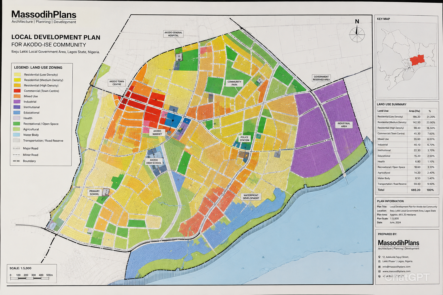
An estate layout plan, sometimes called a site layout plan or subdivision plan, is a drawing that shows how land will be divided and organised before development begins. It identifies plots, access roads, drainage channels, open spaces, and areas reserved for community facilities such as schools, places of worship, markets, or recreational spaces, depending on the size of the estate.
During my Town Planning studies at the University of Uyo, one lesson our lecturers repeatedly stressed was that a layout plan is far more than a drawing. It is a practical development guide. Every line on the plan serves a purpose, and the decisions made at that stage can affect landowners and residents for decades.
Many people confuse an estate layout plan with a master plan. The difference is simple. A master plan covers a much larger area, such as a town or local government area, and provides a long-term framework for growth and development. An estate layout plan focuses on a specific parcel of land owned by individuals, companies, or government agencies, while still complying with broader planning policies. In that sense, the master plan provides the direction, while the estate layout plan applies that direction to a particular site.
For a layout plan to have legal standing, a qualified town planner must prepare it and the relevant planning authority must approve it. Once approved, it becomes the official document used by development control officers to assess compliance with planning regulations. Without approval, a layout remains only a proposal, and this often creates serious problems for land buyers and developers.
QUICK TIP
Before you pay anything for a plot, ask the seller for the approval reference of the estate layout plan and the name of the planning authority that approved it. A genuine seller will have this ready, and you can verify it independently before you commit your money.
How the Land Is Shared: Land Use Distribution and Zoning
Why the Sharing Formula Matters
One of the first questions I ask when I look at any layout plan is simple. How is this land being shared? Based on projects I have worked on, a typical residential estate layout shares the land roughly like this, though the exact figures shift depending on the size and location of the site.
| Land Use Category | Typical Share of Total Land | What It Covers |
| Residential plots | 55% to 65% | Plots for houses, the part people actually buy and build on |
| Roads and circulation | 15% to 22% | Primary, secondary and access roads, plus footpaths |
| Open space and recreation | 5% to 10% | Parks, playgrounds, green buffers, setback strips |
| Institutional and commercial | 5% to 10% | School plots, worship centres, neighbourhood shops, clinics |
| Infrastructure and utilities | 2% to 5% | Transformer sites, water tanks, refuse collection points |
When a developer tells me that almost all of a piece of land has been turned into “sellable plots,” with very little left for roads, drainage or open space, I already know that estate will struggle. I have encountered this situation multiple times, and it always plays out the same way. The roads end up too narrow, there is nowhere to put a proper drainage channel, and within a few years, residents are fighting over the small patch of land that should have been a playground but has now become somebody’s extension.
Zoning Hierarchy: Putting Each Use in Its Right Place
Zoning simply means deciding, in advance, what type of activity is allowed in each part of the estate. In practical terms, what usually happens in a well planned estate is this. The plots closest to the main entrance, along the busiest road, are zoned for commercial or mixed use activities, things like a supermarket, a pharmacy, an event centre or offices. As you move further in, the density reduces and the plots become purely residential. Areas close to a stream, low lying land, or land with a steep slope are zoned as green buffer or open space, not as building plots, because building there is asking for trouble.
This hierarchy matters because it prevents the kind of conflict that affects many Nigerian neighbourhoods, where a noisy generator dealer’s shop ends up directly beside someone’s bedroom window, or a worship centre with late night programmes is squeezed between two residential plots with no buffer at all. I have seen this mistake repeatedly, and once people have built, there is very little anyone can do about it.
Mixed Use Integration Done the Right Way
Mixed use does not mean anything goes anywhere. It means specific nodes, usually along the main access road or at a roundabout within the estate, are deliberately designed to carry shops, a small clinic, maybe a nursery and primary school, so that residents do not have to travel far for daily needs. If I were advising a client today on an estate of about five hectares, I would recommend at least one clearly marked commercial node near the entrance, properly separated from the residential core by landscaping or a service road, so that delivery vans and customer traffic do not mix with the quiet streets where people live.
The Road Network: The Skeleton That Holds an Estate Together
If land use distribution is the skin of an estate, the road network is the skeleton. Get it wrong, and no amount of beautiful housing design will save the estate from daily frustration.
Road Hierarchy in a Residential Estate
From what I have seen in practice, a properly designed estate layout uses a hierarchy of roads, not one single road width for everything.
- Primary or distributor roads, usually around 12 to 15 metres wide, carry traffic into and around the estate from the main public road
- Secondary or collector roads, usually around 9 to 12 metres wide, link the primary road to groups of plots
- Access roads or close roads, usually around 6 to 9 metres wide, give direct frontage to individual plots
- Footpaths and walkways, narrower paths that allow pedestrians to move safely without competing with vehicles
One challenge I repeatedly encountered during my internship was visiting sites where every road on the layout plan was drawn at the same width, often the bare minimum allowed. On paper it looked fine. On the ground, once two cars met on what was supposed to be an access road, one of them had to reverse all the way back, sometimes onto someone’s planned setback.
Circulation: Connectivity Versus the Cul-de-Sac Trap
I have worked with clients who love the idea of cul-de-sacs, those dead end streets that feel private and quiet. There is nothing wrong with a few of them in the right places. The problem starts when an entire estate is designed as a maze of dead ends with only one entrance and exit point for the whole development.
The reality on the ground is often different from what the drawing promises. If there is a fire, a flood, or simply heavy traffic at the single entrance during rush hour, everybody is affected at once. A good layout plan balances the calm feeling of close roads with at least one alternative route, a loop road, or a secondary access point, especially once the estate grows past a certain size.
Parking and Pedestrian Provision
Many older estate layouts I have reviewed simply did not think about where visitors would park. The result, years later, is cars parked on the road itself, narrowing an already tight street to almost nothing. In my experience, the safest approach is to design plot sizes and setbacks generous enough that each house can comfortably park at least two vehicles off the road, and to add small visitor parking bays along secondary roads near the commercial nodes.
Plot Sizes, Setbacks and Open Space: The Numbers That Protect Everybody
Choosing Realistic Plot Sizes
Plot sizes should match how people in that location actually live and build. In Uyo and similar cities, I commonly work with plot sizes around 18 metres by 30 metres, or 15 metres by 25 metres for tighter sites, while some estates targeting bungalows on smaller budgets go as low as 15 metres by 20 metres. During studio exercises at university, we were taught that plot sizes should be based on the type of building expected, the parking requirement and the setback rules, not picked randomly just to squeeze out extra plots.
I once reviewed a plan where the developer had taken a site originally designed for plots of 18 by 30 metres and resliced it to fit more plots at 12 by 20 metres, without changing the road widths or drainage. On paper, more plots meant more money. In reality, almost every house built on those resliced plots ended up with little or no setback space, because the building footprint that worked comfortably on the bigger plot was simply squeezed onto the smaller one.
Setbacks: Why Empty Space Is Not Wasted Space
Setbacks are the distances a building must keep from the plot boundaries, the front, sides and back. Many first time landowners see this as wasted space that could have been more rooms. I used to think the same thing until I gained practical exposure, and now I explain it differently to every client.
- Front setbacks allow light and air into the building, give room for a small gate or porch, and protect the building if the road in front is ever widened
- Side setbacks allow proper ventilation between neighbouring houses, give access for maintenance, and reduce fire risk from one building to another
- Rear setbacks give room for a kitchen garden, a borehole, a soakaway, or future extensions like a self contained unit
A practical lesson from my internship was watching a building that had been constructed right up to the boundary on all sides. When the owner needed to dig a soakaway for a blocked septic system, there was nowhere on his own land to put it, and he had to negotiate, awkwardly, with his neighbour for access. That single mistake cost him far more in goodwill and money than the small extra room he gained by ignoring his setbacks in the first place.
Open Space: Parks, Playgrounds and Green Buffers
Open space allocation should never be an afterthought, a leftover piece of land nobody wanted. In a good layout, open space is deliberately positioned where it will actually be used, close to the residential core, not hidden at the back of the estate where nobody passes.
For estates of reasonable size, I always recommend at least one functional open space, even if small, that can serve as a children’s playground, a community gathering point, or simply a green lung for the neighbourhood. Beyond the social value, green buffers along boundaries and around drainage channels also help slow down water during heavy rain and reduce erosion, something we will look at more closely in the next section.
Drainage, Flooding and Environmental Management: The Section Most Layouts Get Wrong
Reading the Land Before Drawing the Plan
This is something I have encountered many times, and it is honestly one of the most common reasons estates in Nigeria flood. A layout plan is drawn on a flat sheet of paper, but the land itself is never flat. It has slopes, low points, and natural paths that water has followed for years, long before any human being thought of building there.
One lesson I learned early is that a good layout plan respects the natural drainage pattern of the site instead of fighting it. This means roads and drainage channels are positioned to follow the natural fall of the land, directing water towards a proper outfall, whether that is a stream, a river, or a designed retention area, rather than blocking it.
Drainage Systems Within the Estate
In practical terms, a workable drainage system for an estate includes primary drains along the major roads, secondary drains along access roads that feed into the primary drains, and properly sized culverts wherever a road crosses a natural water path. Every drain should have somewhere to go. I have reviewed layouts where the drainage along the roads simply ended at the estate boundary, with no connection to anything beyond, as if the water was expected to disappear once it reached the fence.
Flood Control and Building on Floodplains
During site analysis assignments at university, we were taught to identify floodplains and low lying areas early, because no amount of good architecture saves a building constructed in the path of seasonal flooding. I have seen this issue firsthand, more than once, here in Uyo, where plots close to a stream or wetland were sold and built on, only for the owners to spend every rainy season fighting water that has nowhere else to go, since the natural channel was blocked by buildings.
A good layout plan keeps an adequate buffer along any stream or wetland, marks low lying areas as green space or retention ponds rather than building plots, and where building on slightly raised ground is unavoidable, recommends a minimum plinth height for foundations so that floor levels sit safely above the expected flood level.
EXPERT NOTE: As a general rule of thumb from practice, finished floor levels should sit at least 45 to 60 centimetres above the highest flood level recorded for that area, and even higher near stream banks or known low points.
Environmental Management and Climate Responsiveness
Environmental management in a layout plan covers things like tree planting along roads and in open spaces, designated points for refuse collection so waste does not end up in drains, and protecting any existing mature trees that provide shade and help with drainage. From a planning perspective, I strongly recommend that estates retain as many existing trees as possible during land clearing, because replacing decades of growth takes decades, while clearing everything takes one bulldozer and one afternoon.
Climate responsiveness, in simple language, means designing the layout with our weather in mind. Roads and plots oriented to allow cross ventilation reduce the need for excessive air conditioning. Tree lined streets keep the estate noticeably cooler. Wider drains and more generous green areas help the estate cope with the heavier rainfall patterns we have been experiencing in recent years.
Utilities and Infrastructure Planning: Getting the Services in Before the Houses
One challenge I repeatedly encountered during my internship was visiting estates where every single house had its own borehole, its own generator house, and its own soakaway, even though they were sitting fifty metres from each other on the same layout. Nobody had planned for shared infrastructure from the beginning, so everybody solved the same problem individually, at far higher cost than if it had been planned centrally.
Water Supply
A good layout plan identifies, even if only in principle, where a central borehole or water scheme could serve a cluster of plots, with pipe routes reserved along road corridors. Even where individual boreholes remain the practical reality for now, reserving space for a future shared scheme means the estate is not locked out of better options later.
Electricity and Power Infrastructure
Transformer locations, and the routes for both underground and overhead power lines, should be marked on the layout plan from the start, ideally at the edge of open spaces or institutional plots rather than squeezed onto a residential plot’s boundary. I have reviewed layouts where the transformer location was an afterthought, eventually placed wherever there happened to be a gap, sometimes directly facing someone’s living room window.
Sewage, Waste and Telecom Ducting
For larger estates, a layout plan should at least consider a centralised sewage treatment approach rather than leaving every plot to manage its own septic tank and soakaway indefinitely. Even on smaller estates where individual septic systems remain the norm, plot layouts should leave enough rear setback space for a properly sized soakaway, positioned away from boreholes. Space for telecom ducting along road corridors, though often ignored, saves a lot of road digging and disruption once residents start requesting internet and cable connections.
Development Control, Approval and the Planning Regulations Behind It All
How a Layout Plan Becomes Official
In practical terms, the journey of an estate layout plan from idea to legally recognised document follows a fairly consistent path, even though the exact offices involved vary slightly from state to state.
- A registered surveyor carries out a survey of the land and produces a survey plan showing the exact boundaries and coordinates
- A town planner studies the site, considers its topography, access and surrounding land uses, and prepares the estate layout plan
- The layout plan is submitted to the relevant state planning authority, such as the Ministry of Lands and Physical Planning or its equivalent agency, for review
- Where necessary, an environmental assessment is carried out, in line with requirements from bodies such as NESREA
- Once approved, the layout is registered and becomes the official reference for development control on that land
I did not learn this from a textbook alone. I have personally taken layout plans through this process, and I can tell you that the approval stage is not a formality to be skipped. An approved layout plan is what protects every future buyer of a plot within that estate, because it confirms that the land use, road network and plot boundaries have been checked against existing planning standards and against any conflicting claims on the land. If you would like professional help preparing or reviewing a layout plan through this process, that is part of what we handle through our planning and design services.
The Role of Professional Bodies
Both classroom learning and field experience support this conclusion. Several professional bodies exist specifically to maintain standards in this process. The Nigerian Institute of Town Planners and the Town Planners Registration Council regulate town planning practice, the Architects Registration Council of Nigeria regulates architectural design, the Council for the Regulation of Engineering in Nigeria regulates engineering input such as road and drainage design, and the Surveyors Council of Nigeria regulates land surveying. When a layout plan has been prepared and reviewed with input from properly registered professionals across these areas, it carries a level of reliability that a layout drawn by an unregistered “agent” simply cannot match.
EXPERT NOTE: When reviewing any layout plan or building design, it is worth confirming that the professionals involved, the town planner, architect, engineer and surveyor, are registered with their respective regulatory bodies. This is not about paperwork for its own sake. It directly affects how reliable the document in front of you actually is.
Development Control After Approval
Approval of the layout plan is not the end of the story. Development control means the planning authority continues to check that buildings going up on each plot actually follow the layout, the approved plot boundaries, the setbacks and the designated land use. This is one of the most common misconceptions I encounter, that once a layout is approved, anything goes after that. The reality on the ground is often different. A plot zoned for residential use in the approved layout cannot simply become a fuel station because the owner decided so, at least not without going through a formal change of use process.
Growth Strategy: Phasing, Population Projections and Smart Growth
Why Phasing Matters
From a planning perspective, I strongly recommend that estates above a certain size be developed in phases rather than all at once. Phasing means the layout plan is designed for the full site from day one, but construction of roads, drainage and plots happens in manageable stages, with each phase fully serviced before the next one begins.
I once reviewed a plan where phase one had been sold and partially built, while phase two remained undeveloped bush directly behind it, with the access road for phase two running, on paper, straight through the back gardens of phase one houses. Nobody had told the phase one buyers that their “back fence” was actually a future road reserve.
Population Projections and Density
During my undergraduate studies, one thing our lecturers constantly emphasized was that planning is forward looking. A layout plan should consider not just how many people will live there on day one, but how many are likely to live there in ten or twenty years, as families grow, as plots get subdivided, or as more intensive housing types replace early bungalows. This projection informs decisions like how many plots should be reserved for a school, whether one neighbourhood clinic is enough, and how wide the main roads really need to be.
Smart Growth and Future Expansion
Smart growth, in plain language, simply means growing the right way rather than growing in every direction without limit. A layout plan that supports smart growth keeps development reasonably compact, makes good use of mixed use nodes so people do not need to travel far for everyday needs, and deliberately reserves land at the edges of the estate, or along key roads, for future expansion, rather than allowing that land to be randomly built on by whoever gets there first.
If there is one thing I would encourage every developer to do, it is to mark out, clearly, on the approved layout, exactly where future phases or extensions will connect to the existing road and drainage network. That single decision, made early, prevents years of disputes later.
GIS, Mapping and the Practical Realities of the Site
Why GIS Matters Before the First Line Is Drawn
My academic training exposed me to Geographic Information Systems, commonly called GIS, as a tool for understanding a site before designing anything on it. In practical terms, GIS allows a planner to overlay information such as contour lines, existing access roads, nearby developments and water bodies, to build a realistic picture of the land.
One practical example comes from a project I handled where the client’s survey plan looked perfectly rectangular and straightforward on paper. Once we brought in contour data, it became clear that a noticeable stream course cut diagonally across what would have been four plots. That single piece of information completely changed the layout, moving those four plots into a green buffer zone instead, and saving the client from a costly mistake.
Feasibility Realities
The theory sounds reasonable on a flat drawing, but real projects tell a different story once you account for soil conditions, rock outcrops, the cost of cutting and filling to level a site, and the location of existing utility lines that may run across the property. A good layout plan is produced with these realities in mind, not designed in isolation and then forced onto the ground regardless of what is actually there.
Practical Site Considerations
Beyond the technical data, practical considerations include how the new estate will connect to existing roads outside its boundary, whether neighbouring landowners have rights of way that must be respected, and how construction traffic will move during the building phase without destroying existing community roads. This is not just theory. I have seen it happen, where an estate’s only entrance was also the only access road for an existing community, and construction traffic alone created friction long before the first resident moved in.
A Quick Comparison: Good Layout Plan Versus Poor Layout Plan
Sometimes the easiest way to see what makes a good estate layout plan is to place it side by side with what a poor one looks like. Here is a quick comparison drawn from layouts I have personally reviewed over the years.
| Feature | Good Estate Layout Plan | Poor Estate Layout Plan |
| Road access | Every plot reaches a properly sized road | Some plots are landlocked or reached only by footpath |
| Drainage | Channels follow the natural slope to a real outfall | Drains end abruptly at the boundary or are missing |
| Open space | Deliberately placed where people will use it | Whatever odd shaped land is left over after selling plots |
| Setbacks | Clearly marked and respected during construction | Ignored or “adjusted” once building starts |
| Approval status | Formally approved by the planning authority | Exists only as an informal drawing from an agent |
| Future growth | Expansion areas and connections clearly marked | No provision, leading to disputes later |
The Nigerian Reality Layer: What Happens When There Is No Proper Layout Plan
I want to be honest with you in this section, because this is where theory meets the streets we all live on. Without a master plan or a properly approved estate layout, here is what tends to follow, and I have seen each of these play out somewhere in Nigeria.
Uncontrolled Growth and Land Disputes
Land gets developed haphazardly, with buildings going up without any setback, sometimes right on top of where a road or drainage channel should have been. Informal settlements spring up on land nobody officially planned for housing, and government land or designated reserves get quietly encroached upon, plot by plot, until reclaiming them becomes politically difficult and expensive.
Traffic, Housing and Land Use Conflicts
Narrow, poorly connected roads lead to daily traffic congestion, even in areas with relatively few vehicles, simply because the road network was never designed to handle the buildings that eventually filled every available space. I have worked with clients whose houses ended up directly beside a noisy workshop or a market that grew organically because there was no zoning to keep incompatible activities apart. Overcrowding follows, often with poor housing quality, because there was no planning standard guiding what could be built and how densely.
Infrastructure, Flooding and Environmental Problems
Without planned infrastructure corridors, extending water, electricity and proper drainage to these areas later becomes extremely expensive, sometimes practically impossible without demolishing existing structures. Natural drainage channels get built over, and the predictable result is the kind of urban flooding that has become painfully familiar across many Nigerian cities during the rainy season, along with the erosion that follows when water has nowhere proper to go. Green spaces disappear, wetlands get filled in, and the loss shows up later in poorer air quality, more flooding, and fewer places for communities to gather.
Public Health, Economic and Social Costs
Poor sanitation, blocked drains and standing water create breeding grounds for mosquitoes and contribute to the spread of preventable diseases. Property values in poorly planned areas tend to lag behind similar areas that were properly laid out, because investment attractiveness drops when buyers cannot be sure their environment will not deteriorate further. Socially, the lack of shared spaces, parks, markets in the right locations, community centres, tends to reduce the everyday interactions that hold neighbourhoods together, and can contribute to higher crime opportunities in poorly lit, poorly connected areas.
Disaster Risk and Future Costs
Perhaps most worrying, in an emergency, whether a fire, a flood, or any other disaster, narrow roads and poor access make it difficult for help to arrive in time. And when government eventually decides to fix these areas through urban renewal, the cost is many times higher than it would have been to plan properly from the start, because now roads must be widened through existing buildings, and people must be compensated and relocated.
I am not sharing all this to frighten anyone. I am sharing it because every single one of these problems traces back, in one way or another, to decisions that either were never made, or were made without a proper layout plan guiding them. The good news is that all of it is preventable, and that is exactly what the rest of this guide has been showing you.
The Human Lifestyle Layer: How a Good Layout Shapes Everyday Living
Beyond drawings and standards, an estate layout plan ultimately decides what daily life feels like for the people who live there.
Picture a child who can walk safely to a nearby primary school within the estate, along a footpath separated from heavy traffic, because the layout deliberately placed the school plot within walking distance of the residential core and connected it with safe pedestrian routes. Compare that to a child who must be driven, every single day, because the nearest school is on the other side of a busy distributor road with no safe crossing.
Picture residents who can walk to a small neighbourhood shop for bread, milk or recharge card, because a mixed use node was deliberately planned within the estate, instead of everyone having to drive out to the main road for the smallest item.
Picture an evening where children can play in a designated open space under the watch of nearby houses, rather than playing in the street because there is simply nowhere else, with all the safety risks that comes with that.
This is community functionality in its simplest form. A good layout plan does not just create plots, it creates the conditions for neighbours to actually become neighbours, for small businesses to find a natural home, and for daily errands to take minutes rather than a full journey by car.
The Construction Experience Layer: What I Have Seen While Supervising Sites
During field inspections, I discovered that many of the problems that show up during construction were actually decided, quietly, at the layout stage, long before any builder picked up a shovel.
When Pegging Does Not Match the Drawing
While assisting with development control activities, I once encountered a site where the plot pegs on the ground did not match the dimensions on the approved layout plan. The discrepancy was small, less than a metre, but it was enough to push the foundation of a building partly into what should have been a drainage reserve. We caught it before the foundation was poured, but I have also seen cases, on other sites, where this kind of error was only discovered after the roof was on, and the cost of correcting it at that stage is simply not the same conversation.
When Setbacks Get “Adjusted” During Construction
A challenge I repeatedly encountered during my internship was the temptation, once a building is going up, to push the foundation a little closer to the boundary, “just this small,” to gain extra room inside. I witnessed firsthand how that small adjustment, repeated by several plot owners along the same road, eventually meant the road itself effectively narrowed, because vehicles now had to leave a wider gap from buildings that had crept closer to the carriageway than the layout intended.
Practical Advice for Anyone About to Build
If I were advising a client today, before laying a single block, I would recommend confirming the approved layout plan, getting the plot re pegged by a registered surveyor if there is any doubt, and checking the approved setbacks against the actual building design, not against what the neighbour did. This is the approach I would personally take, and it has saved every client who followed it from the kind of “small adjustment” that becomes a big problem later.
The Investment Layer: Why a Good Layout Plan Protects Your Money
Many people think of an estate layout plan as a technical document that only concerns planners and government offices. In reality, it is one of the most important documents protecting the money you are about to put into land.
Approved Layouts and Title Documents
Based on projects I have worked on, land within a properly approved estate layout has a much smoother path to obtaining proper title documents, such as a Certificate of Occupancy or a Governor’s Consent, because the planning authority has already confirmed that the land use, plot boundaries and road access are in order. Land within an unapproved or informal “layout” often gets stuck at exactly this stage, sometimes for years, while the owner tries to regularise documents for land that was never properly planned in the first place.
Resale Value and Marketability
From what I have seen in practice, plots within well planned estates, with good roads, working drainage, and visible amenities like green spaces or a school, tend to hold and grow their value more reliably than plots in areas where every house looks like it is fighting for space with its neighbours. When a buyer comes to inspect a plot and can see a clear road reaching it, drainage that actually works, and a sense that the area was thought through, that confidence translates directly into what they are willing to pay.
The Long Game
I have worked with clients who initially balked at the idea of “losing” plots to roads, drainage and open space, seeing it purely as lost income. Years later, some of those same clients have come back to tell me that their estate is now one of the more sought after addresses in the area, precisely because it does not have the problems that plague nearby developments that squeezed every available square metre into “sellable” plots. This conclusion is based on both academic training and real world observation, not just theory. A layout plan that respects planning standards is not a cost. It is an investment that pays out for decades.
Mistakes to Avoid When Reviewing or Designing an Estate Layout Plan
This is one of the most common misconceptions I encounter, that all these mistakes only happen to “other people.” Based on everything covered in this guide, here are the mistakes I see most often, listed plainly so you can check your own situation against them.
- Buying land described as “an estate” without seeing an approved layout plan
- Allowing roads and drainage to be squeezed to the bare minimum to create more “sellable” plots
- Ignoring the natural slope and drainage pattern of the site when designing road and drainage layout
- Placing residential plots directly beside industrial, market or heavy commercial uses without any buffer
- Leaving open space allocation as whatever land is left over, rather than choosing it deliberately
- Building right up to plot boundaries, leaving no room for setbacks, soakaways or future maintenance
- Treating utility planning, water, power and sewage, as something each individual plot owner figures out alone
- Skipping the formal approval process because it takes time or money
- Failing to mark out future expansion areas, leading to confusion when phase two begins
- Assuming that once a layout is approved, no further checks during construction are needed
Quick Checklist: Fifteen Signs of a Good Estate Layout Plan
Before you commit to buying land, building on it, or approving a design for your own estate, run through this checklist. If most of these are present, you are likely looking at a layout that will serve people well for decades.
- The layout plan has been formally approved by the relevant state planning authority
- Every single plot has direct access to a properly sized road
- Roads follow a clear hierarchy, with wider primary roads and narrower access roads
- There is more than one route in and out of the estate, especially for larger developments
- Drainage channels follow the natural slope of the land and connect to a real outfall
- Low lying areas and stream banks are kept as green buffer, not building plots
- Setbacks are clearly marked and consistent with planning standards for that plot size
- At least one functional open space is positioned where residents will actually use it
- Land use zones are clearly separated, with buffers between incompatible activities
- A mixed use node provides for everyday shopping and small services within walking distance
- Space is reserved along roads for utilities such as water pipes, power lines and telecom ducts
- Institutional plots, such as a school or worship centre, are positioned for safe pedestrian access
- Future expansion areas and their connection points are clearly marked on the plan
- The plan reflects the actual topography of the site, not an imaginary flat surface
- Plot dimensions on the ground match the dimensions shown on the approved plan
Frequently Asked Questions About Estate Layout Plans
What is the difference between a survey plan and an estate layout plan?
A survey plan shows the exact boundaries, dimensions and coordinates of a piece of land, prepared by a registered surveyor. An estate layout plan goes further, showing how that land will be divided into plots, roads, drainage and other uses, prepared by a town planner and approved by the planning authority. You need both, and they must agree with each other.
How many plots can I realistically get from one hectare of land?
It depends heavily on plot sizes and how generous the roads, drainage and open space are. As a rough guide, after allowing properly for roads, drainage and open space, a hectare laid out with plots of around 18 by 30 metres typically yields somewhere in the range of twelve to sixteen plots, not the twenty or more that some informal layouts try to squeeze in by cutting roads and setbacks to almost nothing.
Who approves estate layout plans in Nigeria?
This is handled at state level, usually by the Ministry of Lands and Physical Planning or an equivalent agency, such as the Akwa Ibom State Geographic Information Agency here in my state. The process typically involves review by qualified town planners within that agency, checking the layout against existing planning standards and any wider master plan for the area.
Can plot sizes or land uses be changed after the layout plan is approved?
Changes are possible, but they are not automatic. Any significant change, such as converting a residential plot to commercial use, or merging two plots into one, generally requires a formal application for change of use or layout amendment, reviewed by the same planning authority that approved the original layout.
What is a reasonable road width for a residential estate in Nigeria?
In my experience, access roads serving individual plots work well at around 6 to 9 metres, secondary roads at around 9 to 12 metres, and the main road into a sizeable estate at around 12 to 15 metres or more, depending on expected traffic. These figures can vary based on local standards, but the principle of having a clear hierarchy, rather than one width for everything, stays the same.
How can I confirm that an estate layout plan is genuinely approved?
The safest approach is to request a copy of the approved layout plan along with evidence of approval from the relevant planning authority, then independently verify this with that authority rather than relying only on what the seller or agent provides. A town planner can also help you cross check the layout against the plot you are being shown, to confirm they actually match.
Finally: What This Means for You
If there is one lesson from this guide, it is that a good estate layout plan is not decoration or bureaucracy. It determines whether an estate functions smoothly for decades or creates problems such as narrow roads, poor drainage, boundary disputes, and difficulties obtaining title documents. Whether you are a buyer, developer, community leader, or government official, these principles are practical, not theoretical. They are drawn from real projects, real sites, and real outcomes I have witnessed in Akwa Ibom State and other parts of Nigeria. Good planning protects investments, improves livability, and supports orderly, sustainable development.
If you are currently looking at land and want a second opinion before you commit, or if you are planning an estate and want a layout plan that follows these standards from the start, that is exactly the kind of work we do. You can explore ready made layout templates in our Plans Library, learn more about how layout plans, survey plans and site development plans fit together in our Plan School, or get in touch directly through our Services page to discuss your specific site.
Take a moment to look again at the checklist above. If you already own land, walk through it honestly. If something does not match, it is far better to find out now, while changes are still possible, than after the first block has been laid. And if this guide has helped you see your land, or your community, a little differently, feel free to share it with someone who is about to make the same decisions you are making today. You can also start from our homepage to explore everything else MassodihPlans offers Nigerian property owners and builders.
Suggested Related Reading on MassodihPlans
This article connects naturally with other practical guides on the site. If the matching articles are already published, link the anchor text below to them. If not yet published, these are strong topics to prepare next, since readers of this guide will naturally want to go deeper on each one.
- A guide to site development plans, for readers who want to see how an estate layout plan connects to the next stage of design
- A guide to survey plans in Nigeria, for readers who want to understand the document that comes before any layout plan
- A guide to building approval and development control in Akwa Ibom State, for readers who want the step by step process explained
- A guide to environmental management plans for housing estates, for readers who want to go deeper on drainage and environmental issues raised here
- A guide to construction costs in Uyo, for readers planning to build on a plot within a newly laid out estate
Related Posts
- Architectural Engineering and Architectural Design Courses for House Building Plans
- Cost of Master Plan Preparation for Communities and Institutions
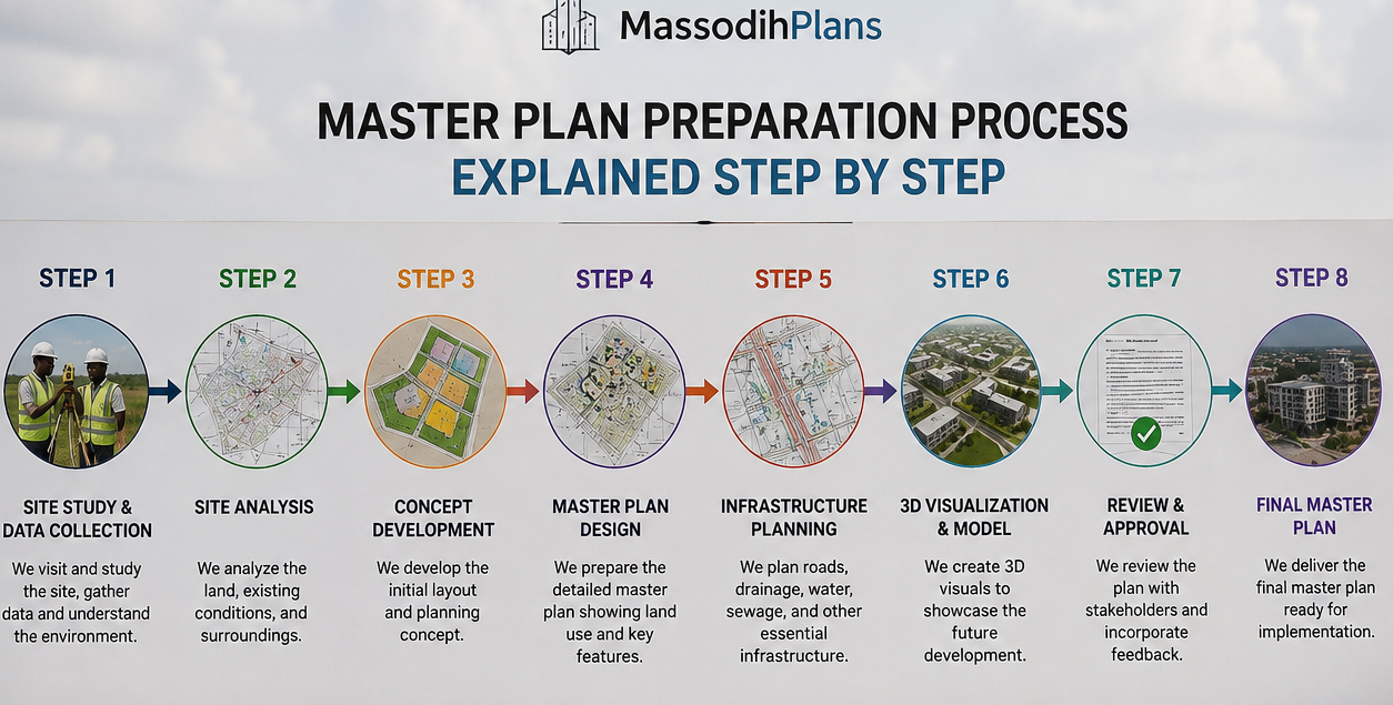
- Master Plan Preparation Process Explained Step by Step
- Cost of Building a House in Uyo: Honest Budget Guide for Property Owners
- Housing Estate Layout Plan: Why Every Estate Needs One in Nigeria and Beyond
- 2 Bedroom Flat Plan for Narrow Plots in Nigeria: Complete Layout, Dimensions, and Building Guide
- Commercial Development Planning Costs: What Every Investor Must Know Before Spending a Kobo
- Why District Planning Is Important for Urban Development
- Site Development Plan Cost: What Every Property Owner Must Know Before Building
- Environmental Management Plan Cost Guide for Developers in Nigeria and Beyond
- Survey Plan Cost in Nigeria: Fees, Process and Hidden Expenses
- Layout Plan Cost in Nigeria and Abroad: What Every Landowner Must Budget Before Building
- Smart Ways to Reduce Building Costs in Nigeria Without Reducing Quality
- Cost of Blocks, Cement, Iron Rod and Roofing Sheets in Uyo: Real Prices From the Field Now
- Estate Development Cost Breakdown: What Developers Should Budget For
- Why Local Development Plans Matter for Communities