What Happens to Your Estate Without a Layout Plan? (The Truth Nobody Tells You)
Housing Estate Layout Plan
Let me answer your question directly before anything else: a proper housing estate layout plan is the single most important document that determines whether your housing development becomes a liveable, valuable, and sustainable community or a chaotic, flooding-prone, conflict-ridden neighbourhood that nobody wants to live in.
I have seen it happen on both sides. And I have reviewed well-structured estate layouts that gave developers confidence, attracted buyers, and sailed through approval in weeks. I have also walked through communities in Uyo, Port Harcourt, and across the South-South where there was no layout, no planning, no setbacks and today those areas are drowning in flood water every rainy season, houses sit on each other, roads are too narrow for an ambulance, and land disputes are endless.
I am writing this for you: the private developer, the family looking to build in an estate, the government agency trying to understand what went wrong, or the student who is just beginning to see how town planning really works. By the time you finish reading, you will understand exactly what a housing estate layout plan is, what it contains, why every estate must have one, and what happens when it does not exist.
Expert Note from Massodih: Over the years, I have noticed that many Nigerian landowners and developers treat a layout plan as a bureaucratic requirement. In reality, it is your development roadmap. It protects your investment, guides your contractor, and secures your residents. Every serious estate begins with a serious layout plan.
What Is a Housing Estate Layout Plan? (And Why the Definition Matters)
A housing estate layout plan is a scaled technical drawing and planning document that shows how land within an estate will be organised, divided, and used. It defines where each plot sits, how roads run through the estate, where drainage channels go, how public open spaces are placed, and what activities are permitted on each section of land.
During my undergraduate studies in Town Planning at the University of Uyo, one thing our lecturers constantly emphasised was this: a layout plan is not just a drawing. It is a legal instrument, a design guide, and a social contract between the developer and the future residents of that community.
Think of it this way. Imagine you want to build a new neighbourhood from scratch. You have 10 hectares of land. Without a layout plan, every family will build wherever they like, at whatever angle they choose, without leaving space for roads or drainage. Before long, the area looks like a dense bush of buildings. That is literally what you see in many older Nigerian communities today and it costs billions to correct.
A proper layout plan prevents that from the beginning. It does the thinking before the building starts.
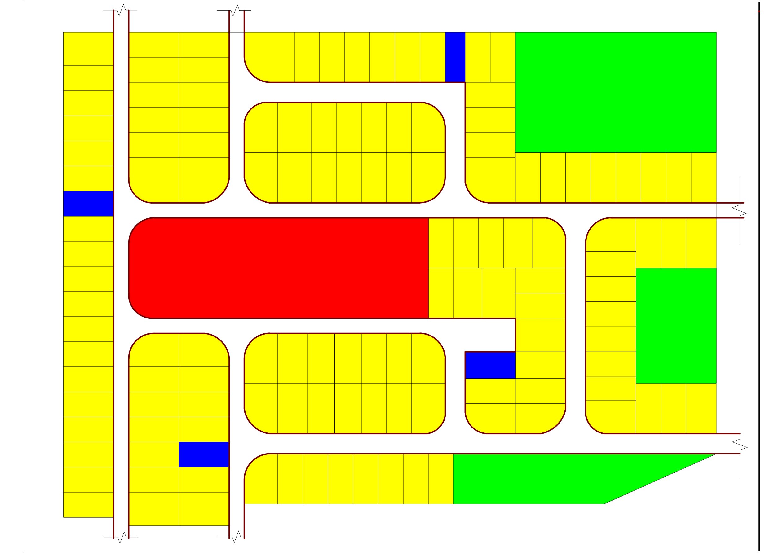
Key Components Included in a Housing Estate Layout Plan
- Land use distribution and zoning designations
- Road hierarchy and circulation network
- Plot sizes, shapes, and arrangement
- Building setback lines on all sides
- Open space and recreational allocations
- Drainage channels and flood control features
- Infrastructure corridors (electricity, water, sewage)
- Public facility sites (schools, markets, clinics, worship areas)
- Environmental buffers and green corridors
- Development phasing and expansion zones
The Nigerian Reality: What Happens Without a Layout Plan
This is the section most planning articles skip. They talk theory and regulations but they never show you what the ground really looks like when there is no layout. I have seen it firsthand and I want you to understand it clearly.
I once reviewed a case where a family built four residential houses on a piece of land in the outskirts of a fast-growing city. No survey, no layout, no setbacks. Within five years, six other families had done the same thing around them. By year ten, the area had become a neighbourhood of about forty structures. None of them had road access beyond a narrow footpath. No drainage existed. In the rainy season, every single compound flooded. A woman lost her infant during a flooding incident because no emergency vehicle could reach her. That story stayed with me.
This is not an isolated story. It is the daily reality in dozens of communities across Nigeria including areas in Uyo, Aba, Onitsha, Benin City, Ibadan, and the outskirts of Lagos. The consequences are severe and they follow a predictable pattern.
The 15 Problems That Follow an Estate Without a Layout Plan
Based on both academic training and real-world observation, here are the specific consequences of developing a housing estate without a proper layout plan:
1. Uncontrolled Urban Growth
- Buildings go up haphazardly without setbacks or alignment
- Urban sprawl pushes development into farming land and forests
- Government land gets encroached upon and reselling becomes a legal battle
- Illegal settlements form at the edges, which are nearly impossible to upgrade
- No mechanism exists to guide future growth into the right areas
2. Traffic and Transportation Breakdown
In my experience, one of the earliest signs of poor planning is road access. In one housing layout project I reviewed on the outskirts of Uyo, the internal road was only 3.5 metres wide. A standard residential road in Nigeria should be between 7.5 and 12 metres wide depending on the hierarchy. Emergency vehicles, furniture trucks, and even larger SUVs could not navigate that road.
- Roads become too narrow for two-way traffic
- No parking spaces exist, so vehicles block whatever roads are there
- Pedestrians walk on the carriageway because there are no walkways
- Public transport operators avoid poorly accessed estates
- Road accidents increase because of poor road geometry
3. Housing Problems and Slum Formation
- Overcrowding becomes the norm when plots are not properly sized
- Incompatible land uses mix randomly: a mechanic workshop beside a bedroom window
- Slum conditions develop within a generation of unplanned building
- Accessing basic services like schools, hospitals, and markets becomes an ordeal
- Property values drop and the estate loses investment attractiveness
4. Land Use Conflicts
I have worked with clients who came to me after serious disputes had already started. In one case, a commercial plaza was built directly across from a residential compound. The noise, the traffic, the lights at night. The family could not sleep. They had not been consulted because there was no layout plan that reserved or excluded commercial uses from that section of the estate.
- Industries and workshops end up beside residential buildings
- Religious buildings cause friction when placed near sensitive areas
- Markets spring up in residential zones, bringing noise and waste
- Commercial activities invade quiet residential neighbourhoods
- Environmental and noise pollution creates daily conflict
5. Infrastructure and Utility Failures
- Water supply lines cannot be planned without knowing plot locations
- Electricity distribution becomes irregular and expensive to extend
- No sewage system is designed because there was no plan to integrate one
- Roads designed after construction costs far more than roads designed from the start
- Utility extension is difficult and disruptive once buildings are in place
6. Flooding and Drainage Disasters
This is the one that breaks my heart most. Every year in Nigeria, communities flood and people lose property, crops, and lives. A significant portion of that flooding is not just about rainfall. It is about buildings constructed on natural drainage paths, channels that were blocked because no layout defined them, and roads that have no gutters because no one planned for water flow.
- Buildings go up on floodplains that should have been avoided
- Natural drainage channels get blocked and water has nowhere to go
- Urban flooding destroys roads, furniture, crops, and structure foundations
- Erosion cuts deep gullies through neighbourhoods
- The rainy season becomes a crisis season for unplanned communities
7 to 15: The Full Cascade of Consequences
The problems do not stop at flooding. They continue through every layer of community life:
- Environmental degradation: green spaces disappear, trees are removed, and wetlands are filled
- Public health problems: diseases spread in poorly drained, overcrowded areas
- Economic challenges: property values drop, businesses avoid poorly accessed areas
- Social problems: crime increases in areas with no public lighting or open spaces
- Disaster risks: fires spread faster, emergencies take longer to respond to
- Governance problems: government cannot enforce regulations on estates with no layout
- Inadequate public facilities: no space was reserved for schools, clinics, or parks
- Security problems: criminal elements exploit dark, narrow, inaccessible corners
- Future development constraints: correcting a poorly planned estate costs ten times more than planning it right the first time
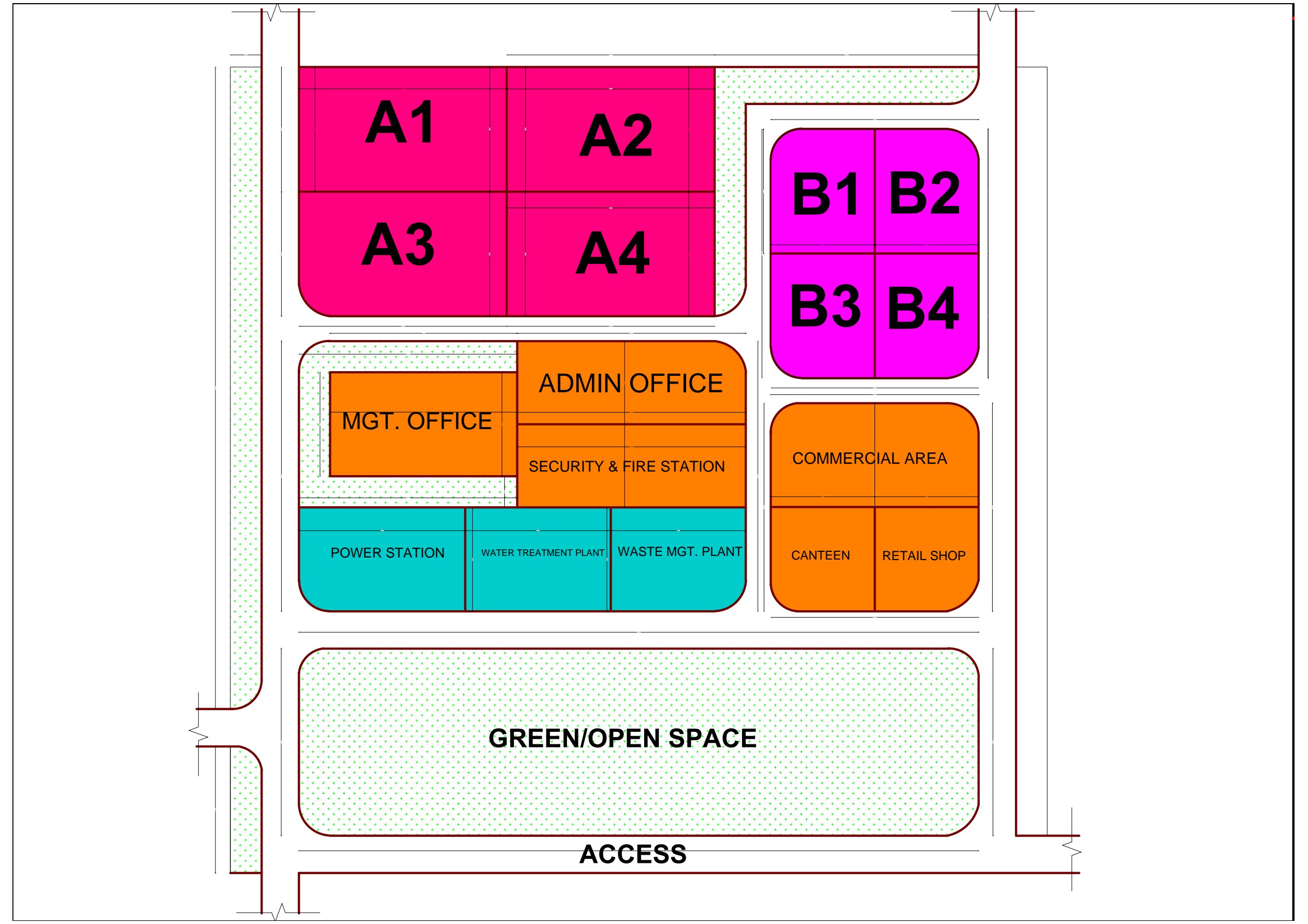
What a Proper Housing Estate Layout Plan Contains: The Full Technical Picture
Now let me walk you through what actually goes into a professional estate layout plan. This is not just a checklist. Each component exists to solve a specific real-world problem.
Land Use Distribution and Zoning
A layout plan divides the estate into zones. Each zone has a designated use: residential, commercial, institutional, open space, or transportation. This zoning ensures that incompatible activities do not share the same space. At the University of Uyo, we were taught that zoning is the foundation of land use planning. Without it, the layout has no structure.
In a standard Nigerian residential estate, land use distribution typically looks like this:
| Land Use Category | Typical % Allocation | Purpose |
| Residential Plots | 50 – 60% | Private housing |
| Roads and Circulation | 15 – 20% | Movement and access |
| Open Spaces and Parks | 10 – 15% | Recreation, green buffer |
| Institutional (schools, health) | 5 – 8% | Community services |
| Commercial Areas | 5 – 8% | Shops, small markets |
| Infrastructure Easements | 3 – 5% | Drainage, utilities, roads |
Road Hierarchy and Circulation Systems
One of the first things I learned during my internship was that roads in an estate are not all equal. They have a hierarchy, and that hierarchy determines width, design speed, and function. When there is no hierarchy, developers just cut roads wherever they feel like, and the result is an incoherent tangle.
A properly designed estate uses at least three road categories:
- Collector Roads (12 to 15 metres wide): These are the main entry and exit routes of the estate. They carry the highest volume of traffic and connect the estate to the external road network.
- Access Roads (7.5 to 9 metres wide): These are the secondary roads within the estate. Most plots face these roads directly.
- Cul-de-sacs or Service Lanes (4.5 to 6 metres): These serve smaller clusters of plots and are designed for low-speed local traffic.
Each road category also includes considerations for: pavement width, drainage gutters on both sides, pedestrian walkways, turning radii at intersections, and setback from plot boundaries.
Plot Arrangement and Sizes
During studio exercises at university, one of our recurring challenges was arranging plots efficiently without wasting land or creating awkward shapes. In practice, this becomes even more critical because every square metre wasted represents money lost.
Plot arrangement follows basic principles:
- Plots should front access roads on at least one side
- Corner plots require wider setbacks on both road-facing sides
- Plot shapes should be as regular as possible for maximum building efficiency
- Minimum plot sizes should meet state planning standards
- Deep plots should have reasonable depth-to-width ratios to allow proper building design
In Akwa Ibom, for example, minimum residential plot sizes depend on the density zone. High-density zones may allow plots from 300 to 450 square metres. Medium-density residential zones typically require 600 to 900 square metres. Low-density zones may specify 1,000 square metres and above.
Setback Regulations: The Space the Law Protects
This is one of the most misunderstood aspects of estate planning. Many homeowners think setbacks are space they are losing. In practice, setbacks are what protect you, your neighbours, and your investment.
A setback is the minimum distance required between your building structure and a boundary line, whether that boundary is a road, a neighbour’s plot edge, or a waterway. Setbacks exist to provide ventilation, light, emergency access, fire safety, utility corridors, and visual character.
Typical setback requirements in Nigerian residential estates:
- Front setback (facing the road): 3 to 6 metres depending on road category
- Side setback (boundary between plots): 1.5 to 3 metres on each side
- Rear setback: 3 to 6 metres for private green space and ventilation
- Setback from drainage channels: at least 3 to 6 metres
- Setback from electricity lines: varies with voltage level
From a planning perspective, I strongly recommend that any developer or landowner understand the setback requirements for their zone before placing a single block. Violating setbacks creates legal problems that are costly to resolve, especially if a neighbour challenges you during or after construction.
Open Space and Green Area Allocation
When I walk through well-planned Nigerian estates, the feature that most residents appreciate is open space. Parks, sitting areas, children’s play areas. Yet when I walk through poorly planned ones, open space is the first thing that was squeezed out.
A proper layout plan reserves open spaces strategically. This includes:
- Neighbourhood parks (one per cluster of 200 to 400 plots)
- Children’s play areas within safe walking distance of homes
- Green buffers along drainage corridors and watercourses
- Entry/exit landscaped areas at the estate gate
- Future expansion land banked and protected from encroachment
Open space is not just about aesthetics. It is flood mitigation, mental health infrastructure, community cohesion space, and environmental regulation all in one.
Infrastructure Planning: The Invisible Systems That Make an Estate Liveable
My academic training exposed me to the theory of infrastructure planning, but real projects taught me the practical weight of it. Infrastructure is what turns a land subdivision into a functioning community.
Drainage Systems and Flood Control
This is not just a technical subject. It is a survival issue in Nigeria. During field inspections, I discovered that many estate flooding problems were entirely preventable. The drainage was either not designed, or it was designed but not built to specification.
A professional layout plan includes a drainage master plan that addresses:
- Surface water runoff collection from roads and plots
- Sizing of drainage channels based on catchment area and rainfall data
- Direction of flow and outfall points to natural drainage
- Flood risk zones identified and excluded from building
- Retention and infiltration areas to slow runoff
- Culverts under roads at drainage crossing points
Without drainage planning, you are essentially hoping it does not rain too much. In South-South Nigeria, that hope will fail you every single year.
Water Supply Planning
A layout plan coordinates the route and sizing of water supply pipes. It identifies the location of overhead tanks or boreholes, the distribution network from source to each plot, and the easements required to maintain those lines. Without this coordination in the original layout, water infrastructure becomes a patchwork of pipes that break, lose pressure, and contaminate easily.
Electricity Distribution Corridors
The layout plan designates power line routes and transformer locations. It ensures that high-voltage lines have adequate clearance from buildings, that transformer locations are accessible for maintenance, and that distribution lines do not conflict with building setbacks.
Sewage and Waste Management
In well-planned estates, sewage systems are integrated from the beginning. Septic tank locations are coordinated. In higher-density estates, centralised sewage treatment facilities are planned. Solid waste collection points are designated so that refuse does not accumulate on roads or in drainage channels.
Environmental Management and Climate-Responsive Planning
Both classroom learning and field experience support this conclusion: a housing estate that ignores its environment is one that will fight its environment for generations.
A climate-responsive layout plan considers:
- Building orientation to maximise natural ventilation and reduce heat gain
- Tree planting zones along roads and in open spaces to moderate temperature
- Natural vegetation buffers along watercourses and slopes
- Permeable surface materials in open areas to support groundwater recharge
- Avoidance of wetlands, mangroves, and high-risk erosion zones for building
- Waste management zones designed to prevent environmental contamination
In practical terms, what usually happens is that developers pay for environmental consequences years after construction when drainage fails, trees are gone, and the estate bakes in heat that could have been mitigated by a few hundred trees planted in the original layout plan.
Development Control and Planning Regulations
In Nigeria, estate layout plans must comply with state town planning laws and regulations. Each state has a physical planning authority: in Akwa Ibom it is the Akwa Ibom State Physical Planning Board; Rivers State has its own equivalent; Lagos operates LASDRI and other agencies. These agencies review, approve, and register layout plans.
Development control is the mechanism through which planning regulations are enforced. When a layout plan is approved, it becomes the baseline against which all subsequent building approvals are issued. A plot that violates its approved layout risks having its building approval refused.
The Planning Approval Process for Housing Estate Layouts in Nigeria
- Pre-application consultation with the relevant state planning authority
- Site survey and topographic analysis conducted by a licensed surveyor
- Preparation of layout plan by a registered Town Planner (TOPREC-registered)
- Submission of layout plan application with supporting documents
- Technical review and site inspection by the planning authority
- Review committee consideration and conditional or final approval
- Registration of the approved layout and issuance of layout approval certificate
- Implementation monitoring and periodic inspections during development
Important: In Nigeria, only registered Town Planners (registered with TOPREC) are authorised to prepare estate layout plans for approval. Working with an unregistered consultant may result in rejection of your plan and loss of time, money, and opportunity.
Urban Growth Strategy, Phasing, and Population Projections
One thing my academic training exposed me to in depth was the concept of planned urban growth. An estate layout plan is not just for today. It is designed to accommodate tomorrow.
Development Phasing
Large estates are not built all at once. A phased layout plan divides development into logical stages. Phase 1 opens the core infrastructure, the main roads, drainage, utilities, and the first batch of plots. Phase 2 expands once Phase 1 is substantially occupied. This approach has several advantages:
- Infrastructure investment matches actual population and demand
- Cash flow for the developer is better managed
- Infrastructure does not age unused while waiting for population
- The developer can refine later phases based on resident feedback
- Future expansion zones are protected from premature encroachment
Population Projections and Planning Standards
A professional layout plan calculates the population that the estate will ultimately accommodate. This figure drives everything: road widths, drainage capacity, number of schools and clinics required, size of the market, volume of waste generated, and water demand.
Nigerian physical planning standards, as guided by TOPREC and NPC publications, provide density ranges for different residential categories:
- High-density residential: up to 250 persons per hectare
- Medium-density residential: 100 to 150 persons per hectare
- Low-density residential: below 75 persons per hectare
Getting population projections right at the planning stage means your estate will not be overwhelmed by its own success or starved of activity by over-planning.
GIS and Mapping Integration
Modern estate layout planning increasingly uses Geographic Information Systems (GIS) to analyse land characteristics before designing the layout. GIS allows the planner to layer information about slope, drainage patterns, vegetation cover, existing roads, land tenure, and flood risk on a single digital map. This makes the layout design evidence-based rather than guesswork.
During projects I have participated in, GIS mapping has revealed drainage paths that were not visible on site, identified flood risk zones that saved clients from costly mistakes, and confirmed plot boundaries with precision that manual surveying sometimes missed.
Mixed-Use Integration and Community Functionality
A housing estate is not just a collection of houses. It is a community. And a community needs more than bedrooms. A well-designed layout plan anticipates the full range of human activity that will happen in the estate.
In my experience, the estates that become desirable, long-term investments are the ones that planned for mixed-use integration from the start. This does not mean commercial activities everywhere. It means:
- A neighbourhood shopping cluster at a strategic, accessible location
- A school site reserved and accessible on foot for children
- A health centre or pharmacy positioned centrally
- A place of worship zone buffered from the nearest residential plot
- A community hall or clubhouse for social gatherings
- Adequate parking provisions at all commercial and institutional nodes
This observation comes from practical field experience: estates that lack these community anchors push all activity outside, increase car dependency, reduce the walkability of the neighbourhood, and ultimately become dormitories rather than communities.
The Investment Layer: Why Buyers and Banks Look for the Layout Plan First
If you are developing a housing estate to sell, rent, or mortgage, understanding the investment dimension of a layout plan is not optional. It is essential.
Here is what I have seen repeatedly in practice. When a potential buyer or a bank comes to evaluate properties in your estate, one of the first things they ask for is the approved layout plan. Not just the title document. The approved layout. Because the layout tells them:
- Whether the roads in the estate will ever be maintainable
- Whether the drainage will handle a major rainstorm
- Whether future expansion will happen in a controlled way or chaotically
- Whether the developer had the discipline to plan properly or just subdivided and sold
- Whether the layout is registered, meaning it carries the force of planning law
My experience in planning and design has shown me that properties in approved, well-planned estates command significantly higher values than properties in unplanned areas. The difference can range from 30 to over 100 percent depending on the location and quality of planning.
Investment Insight from Massodih: A properly approved estate layout plan is one of the most powerful marketing tools a developer can hold. It signals seriousness, reduces buyer risk, attracts bank financing, and justifies premium pricing. Do not develop an estate without one.
Smart Growth Concepts and Future Expansion Opportunities
Smart growth is a planning philosophy that encourages development patterns that are efficient, compact, connected, and sustainable. For Nigerian housing estates, smart growth means designing from the beginning with the long view in mind.
Key smart growth principles that should be reflected in a layout plan:
- Design for walkability so residents can reach daily needs without a car
- Reserve land for future expansion before the estate perimeter becomes fixed
- Design road intersections to accommodate future traffic signals
- Size drainage systems 20 to 30 percent above current projections to handle climate variability
- Integrate renewable energy provisions such as solar charging areas in open space design
- Plan for broadband and telecommunications infrastructure from the outset
The reality on the ground is often different. Many developers think short-term and regret it when their Phase 3 expansion is blocked by squatters on land that was never protected in the original layout.
Common Mistakes to Avoid When Developing a Housing Estate Layout Plan
This is one of the most common misconceptions I encounter: that a layout plan is just a drawing and any draughtsman can produce it. The drawing is only the visible part. The thinking behind it requires years of professional training and field experience.
Mistakes I Have Seen Repeatedly
- Ignoring the topography: Building across slopes without understanding water flow leads to flooding and erosion.
- Under-sizing roads: A 4-metre road in an estate of 200 plots will be unusable within five years of full occupation.
- Forgetting drainage easements: Drainage channels need space and maintenance access. Many layouts squeeze them out.
- No open space provision: Green space is not luxury. It is a requirement under Nigerian planning standards.
- Skipping geotechnical analysis: Building on expansive soils, black cotton soils, or waterlogged ground without assessment leads to structural failures.
- Approving informal layouts after construction: I have witnessed attempts to retroactively approve layouts that already had buildings on them. This almost never works cleanly and creates permanent legal complications.
- Ignoring future expansion: Not reserving land for Phase 2 or 3 means the estate will be surrounded by incompatible uses within a decade.
Quick Summary: Why Your Housing Estate Needs a Proper Layout Plan
- A layout plan is the legal, technical, and social foundation of any housing estate
- Without it, flooding, slums, road chaos, and land disputes are near-certain outcomes
- It defines land use zones, road hierarchy, plot sizes, setbacks, open spaces, and infrastructure
- It must be prepared by a TOPREC-registered Town Planner and approved by the state planning authority
- Approved layout plans protect investment, attract buyers, secure bank finance, and command premium prices
- Modern layout planning uses GIS, population projections, and climate data for precision
- Smart growth principles built into the layout protect the estate’s future and your investment
Frequently Asked Questions
Do I need a layout plan if I am only developing a small estate of 20 to 30 plots?
Yes. The size of the estate does not change the legal requirement or the practical need. Even a 20-plot estate needs a proper layout to define roads, drainage, setbacks, and plot boundaries. Many small estate disasters I have witnessed involved fewer than 30 plots.
Who is qualified to prepare a housing estate layout plan in Nigeria?
Only a registered Town Planner licensed by TOPREC (Town Planners Registration Council of Nigeria) is legally authorised to prepare and certify an estate layout plan for regulatory approval. A surveyor provides the survey data. A planner interprets that data into a layout.
How long does it take to get a layout plan approved in Nigeria?
Approval timelines vary by state. In practice, a well-prepared application with complete documentation can receive approval within 4 to 12 weeks. Incomplete applications, missing documents, or sites with contentious land issues can take much longer.
What is the difference between a layout plan and a site plan?
A layout plan covers the entire estate. It shows how the land is subdivided, how roads run, where open spaces are, and how infrastructure is distributed. A site plan is specific to one plot within the estate. It shows how the building sits on that individual plot.
Can an estate layout plan be modified after approval?
Yes, but modifications require a formal variation application to the planning authority. Unapproved modifications to an approved layout are illegal and can result in enforcement action, including demolition orders.
What happens if I buy land in an estate with no approved layout?
You may face difficulties obtaining building approval, securing title documents, accessing public infrastructure, and selling or mortgaging the property in the future. Always ask for the approved layout plan before any land purchase in an estate.
Final Thoughts from Massodih: Plan It Right from the Beginning
If I were advising a developer today, I would say this clearly: do not treat the layout plan as a hurdle to jump over. Treat it as the investment it is. Every naira spent on getting a proper, professionally prepared, and government-approved layout plan is a naira that saves you from floods, disputes, demolitions, and unsold plots.
I have seen communities built without layout plans and I have watched them struggle for decades. I have also seen estates built on solid layout foundations and watched them grow in value, attract responsible residents, and become places families are proud to call home.
The choice is made at the beginning. A few weeks of professional planning prevents thirty years of problems. That is not theory. I did not learn this from a textbook alone. I have seen it, worked through it, and watched the outcomes on both sides.
If you are a developer or a government agency currently planning a housing estate and you need a professionally prepared layout plan, I would be glad to work with you. And if you are still in the information-gathering stage, explore more planning resources on MassodihPlans. Start with the Plan School section to build your planning knowledge, browse the Plans Library to see what professionally designed estates look like, and check our Services page to see how we can help you plan, design, and get approved.
Ready to plan your housing estate the right way?
Visit massodihplans.com/services to discuss your layout plan project with a TOPREC-registered Town Planner. Or explore the Plans Library and Plan School for more resources built specifically for Nigerian developers and landowners.
Explore More
- Plans Library: Browse professionally designed Nigerian house plans and estate layouts
- Plan School: massodihplans.com/plan-school – Free planning knowledge for Nigerian landowners and developers
- Services: Town planning, layout design, and building approval services
- Homepage: Your complete Nigerian architecture and town planning resource
- Nigerian Estate Master Plan for Small Plots: Modern Residential Layout Strategies That Maximize Space
- Small Residential Estate Layout Design in Nigeria: Smart Master Plan Ideas for Limited Land
- Industrial Estate Layout Design in Nigeria: Smart Master Plan for Small Industrial Plots
- Commercial Development Planning Costs: What Every Investor Must Know Before Spending a Kobo
- Why Local Development Plans Matter for Communities
- Site Development Plan Cost: What Every Property Owner Must Know Before Building
- Environmental Management Plan Cost Guide for Developers in Nigeria and Beyond
- Smart Ways to Reduce Building Costs in Nigeria Without Reducing Quality
- Estate Layout Design Services for Property Developers in Nigeria
- What Is a Master Plan and Why Does Every Growing Community Need One?
- 7 Cheapest Areas to Buy Affordable Land in Uyo Before Prices Increase
- Best Nigerian Duplex Designs for 40×80 Plots
- What Is a Survey Plan and Why Do Property Owners in Nigeria Need One?
- How to Build Cities That People Actually Want to Live In: The 2050 Urban Growth Blueprint
Article prepared by Massodih Okon Effiong
About Author
Massodih Okon is a built environment professional with a background in architecture and urban planning. He specializes in practical Nigerian house design guidance through MassodihPlans.com.. He has a Master’s degree in Urban and Regional Planning, a first degree in Geography and Environmental Management, and professional certificates in Architectural Design, Landscape Design, and GIS. With over 15 years of hands‑on experience in architecture, town planning, GIS, and building economics across Nigerian residential and institutional projects, he understands the real challenges Nigerians face when planning and building homes.
At MassodihPlans, Massodih shares practical Nigerian building guides, modern bungalow and duplex house plans, and built environment resources created specifically for Nigerian homeowners, developers, and property investors. His work is based on real‑life conditions in Nigeria, climate‑responsive design, and cost‑effective planning, aimed at helping everyday Nigerians make smarter, more confident building decisions.