Site Plan Analysis and Layout Planning for Land Development and Building
I once got called to a site in Uyo after the owner had already cast the foundation. He wanted me to “just help arrange the compound” parking, fence, a small garden. I walked the plot with him for twenty minutes and found the real problem: the entire foundation sat lower than the neighbouring plots on three sides. Every rainy season, that compound was going to collect water from all three neighbours before it even thought about draining its own. Nobody had done a proper site analysis before design. They had a site plan a nice drawing with the building sitting pretty in the middle of the plot but nobody had actually studied the land first.
That’s the gap I want to close in this article, because it’s the one thing I see repeated more than any other mistake in this profession: people design the building, then discover the land afterward. It should always be the other way round.
What Site Analysis Actually Means
Site analysis is the process of studying a piece of land its shape, its slope, its drainage pattern, what surrounds it, what’s buried under it, what runs past it before you design anything on it. It’s investigation, not drawing. You’re not producing a building layout at this stage. You’re gathering the facts that will make the eventual layout make sense.
Think of it as the difference between a doctor examining a patient and a doctor writing a prescription. Site analysis is the examination. The site plan and layout plan are the prescription. Skip the examination, and the prescription is a guess dressed up as a decision.
Site Analysis vs. Site Plan: They Are Not the Same Thing
This confusion trips up a lot of clients and, honestly, a few young designers too.
Site analysis is the study phase walking the land, measuring it, observing how water moves across it, noting what’s around it, checking what regulations apply to it. The output of site analysis is understanding, sometimes captured as notes, diagrams, or a simple matrix (I’ll show you one further down).
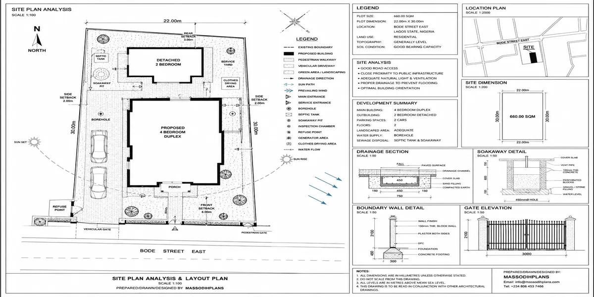
A site plan is a scaled drawing that shows the outcome of decisions made using that analysis the building’s position on the plot, the driveway, the setbacks, the utility connections, the boundary dimensions, all drawn to scale from a bird’s-eye view. It’s the answer. Site analysis is the working-out.
If your designer jumps straight to a site plan without ever walking your land or asking about its slope and drainage, what you’re getting is a drawing based on assumption, not analysis. It might still look correct on paper. Whether it actually works on your land is a different question entirely.
Site Plan vs. Layout Plan: Also Not the Same Thing
This second confusion is more specific to land development subdivisions, estates, multiple plots and it matters if you’re developing more than a single house.
A site plan, as above, deals with one plot and one building’s relationship to that plot its position, setbacks, access, and services.
A layout plan operates at a bigger scale. It’s how an entire piece of land gets divided into multiple plots, streets, drainage channels, and sometimes shared facilities (a green area, a water scheme, an access road network) before individual buildings are even designed. A layout plan is what a town planner produces when subdividing land for an estate; a site plan is what an architect produces for a single plot within or outside that layout.
If you’re buying a single plot inside an already-approved estate layout, you need a site plan for your building. If you’re developing raw land into multiple plots for sale or for a family compound with several buildings, you need a layout plan first, and each eventual building within it gets its own site plan afterward. Getting these two confused is how people end up building a compound without realizing they’ve blocked the only sensible access route for the plot behind them.
Why Land Should Be Analysed Before Design Not After
I want to be blunt about this because it’s the part people underestimate the cost of skipping.
A design that ignores the land’s actual condition doesn’t just look wrong later it costs real money to fix, and sometimes it can’t be fixed at all. A foundation set at the wrong level relative to neighbouring plots means permanent flooding, not a one-time inconvenience. A driveway positioned without checking the road’s traffic direction means reversing into oncoming traffic every single day you own that property. A borehole sited without checking the soil and nearby septic systems means contaminated water a health risk, not just an engineering inconvenience.
Every one of these problems is fixable on paper, before construction, for the cost of a site visit and a few hours of analysis. After construction, the same problems cost multiples of that sometimes in demolition, sometimes in permanent inconvenience you just have to live with.
A proper site plan is built from accurate data about existing conditions typically gathered through a professional land survey establishing property boundaries, topographic elevations, and the location of existing structures and utilities. That’s the honest starting point, and it’s exactly the step that gets skipped when people are in a hurry to see a pretty drawing.
The Full Site Analysis Checklist
Here’s everything I actually walk a site for, in the order I usually check it. Use this whether you’re hiring a professional or trying to understand what your professional should be doing.
Site Boundaries
The legal limits of the plot, taken from your survey plan, not from where a fence happens to currently sit. Fences move, get rebuilt, or get encroached on over the years the survey beacons are the legal truth. Always confirm your boundary against the actual survey pillars on the ground before design, because I have seen plots where the standing fence was a metre or more inside the real boundary.
Dimensions
The actual measured lengths of each boundary and the total plot area, again from the survey, not estimated by eye. Dimensions determine what building footprint and setbacks are even possible a plot that reads as “generous” from the road can turn out to be an awkward trapezoid once you have the real numbers.
Access
Where the road meets the plot, which direction traffic flows, how wide the road actually is, and whether there’s more than one possible entry point. This single factor decides where your gate and driveway can go get it wrong and you’re negotiating with traffic every day for the life of the building.
Orientation
Which direction the plot faces relative to true north, and where the sun rises and sets across it. Orientation decides which walls take the hardest sun exposure and which take the gentlest it directly shapes where you put windows, verandas, and shading.
Topography
The general shape and elevation of the land is it flat, gently sloping, sitting in a depression, or elevated above the road and neighbours? Topography is the physical stage everything else gets built on, and it’s usually visible just by walking the site slowly and paying attention, even before a formal survey confirms it.
Slope
Specifically, which direction the land falls and by how much. This is different from topography in that it’s about direction and gradient, not just overall shape. Slope tells you where water will naturally want to go, which is the single biggest factor in deciding building placement and drainage design.
Drainage
How water currently moves across the site during rain, where does it pool, where does it flow, and where does it eventually leave the plot? This has to be checked ideally during or right after rainfall, not just guessed from a dry-season visit, because dry-season observation hides the exact problem you’re trying to catch.
Vegetation
Existing trees, shrubs, or significant plant cover on the site. Mature trees can be a genuine asset shade, aesthetic value, sometimes a selling point but their root systems can also threaten foundations and underground services if a building is placed too close. Decide deliberately what stays and what goes, rather than clearing everything by default or preserving everything without checking root spread.
Soil Information (Where Available)
And soil type and bearing capacity, ideally from an actual soil test, but even informal historical knowledge of the area (is it reclaimed land, is it known for waterlogging, have neighbouring buildings had foundation issues) is useful input at the analysis stage. Soil condition determines foundation type and cost more than almost any other single factor, so this belongs early, not as a surprise mid-construction.
Neighbouring Development
What’s already built around the plot building heights, how close neighbouring structures sit to your boundary, what activities happen next door (a school, a workshop, a place of worship) that might affect noise, privacy, or access. Your site doesn’t exist in isolation; whatever surrounds it will shape your design decisions whether you plan for it or not.
Existing Structures
Anything already standing on the plot an old building, a fence, a well, a shed that will need to be retained, demolished, or worked around. Note not just that something exists, but its exact position, because “there’s an old well somewhere at the back” is not analysis; a measured location is.
Utilities
What services already run to or near the plot electricity lines and poles, water mains, any existing borehole, and where the nearest transformer or feeder is. This tells you what you’re connecting to and what you might need to provide independently, and it directly affects both cost and layout.
Road Hierarchy
Not all roads serve the same function a major distributor road, a local access road, and a small close or cul-de-sac each carry different volumes of traffic and different planning expectations. Understanding where your access road sits in that hierarchy affects everything from your gate design to what commercial use (if any) might realistically be permitted on the plot later.
Setbacks
The minimum distance your building must sit from each boundary, as required by your local planning authority. These aren’t guidelines they’re usually a hard planning requirement, and they exist to preserve light, air, drainage paths, and safety access between buildings. Confirm your exact setback requirements before finalizing any layout, not after.
Easements
Areas of the plot where, despite it being legally yours, you cannot build because a drainage channel, a utility line, or a right-of-way runs through it. Easements are one of the most commonly missed items in informal site analysis because they don’t always show a physical mark on the ground they exist on paper, in the survey or layout documentation, and you have to actually check for them.
Hazards
Anything that poses a physical risk flood-prone low points, erosion-prone slopes, proximity to a high-voltage line, unstable soil, or a history of ground subsidence in the area. Hazards should be identified honestly at the analysis stage, even when the answer is inconvenient, because designing around a known hazard is far cheaper than discovering it after the fact.
Development Constraints
The combined regulatory and physical limits on what the plot can actually be used for zoning classification, maximum plot coverage, height restrictions, any estate covenant rules if applicable, and any physical constraints (poor access, small frontage, awkward shape) that limit what’s realistically buildable. This is really the summary output of everything above, translated into “here’s what we can and cannot do on this land.”
Do your drainage observation during or right after actual rainfall, not on a dry, sunny site visit. I have changed building placement on plots that looked perfectly flat and fine in the dry season, purely because of what the land did during one heavy rain.
The Site Analysis Matrix
Here’s a simple table I use to keep site analysis organized and to make sure nothing gets skipped. You can use this on your own plot even before you bring in a professional it forces you to ask the right questions early.
| Factor | Question | Planning Implication |
|---|---|---|
| Access | Where is the road, and which direction does traffic flow? | Gate and driveway position |
| Slope | Which direction does the land fall, and by how much? | Drainage routing and building placement |
| Sun | Where does direct solar exposure fall across the day? | Window orientation and shading design |
| Wind | What is the prevailing wind direction? | Ventilation and opening placement |
| Flood | Is the site exposed to flooding or poor drainage? | Building floor level and drainage design |
| Neighbours | What surrounds the site — buildings, uses, heights? | Privacy, noise, and setback decisions |
| Utilities | What infrastructure already exists nearby? | Service connection and cost planning |
If you can only do one thing before hiring an architect, walk your own plot with this table in hand and write down honest answers. Even rough answers give your designer a massive head start, and they’ll immediately notice if the answers point to a problem worth investigating further.
What Should Never Be Designed Before Site Analysis?
This is the section I actually want you to remember, because these are the decisions I see made backwards more than anything else designed first, analysed never, and paid for dearly later.
Building Position
Where the house actually sits on the plot should be a direct answer to slope, drainage, orientation, and setback findings not a default “centre of the plot” decision made before any of that is known. I’ve seen buildings placed in the lowest point of a sloping plot purely because that’s where the plot “looked biggest,” guaranteeing a flooding problem for the life of the building.
Driveway
The driveway route depends entirely on where the road access point is, which direction traffic flows, and how the land slopes near the entrance. A driveway designed before access analysis is a driveway you’ll be arguing with every time you try to reverse out.
Drainage
You cannot design where your drains should run until you know where water actually wants to go on your specific plot. Drainage laid out based on a generic assumption, rather than observed water flow, is drainage that will fight the land instead of working with it.
Septic System
A septic tank’s position depends on soil type, groundwater level, distance from any borehole (yours and your neighbours’), and slope get any of these wrong and you risk contamination or a system that simply doesn’t work as designed. This is one of the clearest examples of why soil information has to come before layout, not after.
Soakaway
Directly tied to soil permeability and groundwater level. A soakaway placed without checking soil absorption capacity can back up, overflow, or fail entirely within a few years and by then it’s buried and expensive to redo.
Borehole
Position depends on soil information, groundwater depth, and critically distance from any septic system or soakaway, on your plot and your neighbours’. A borehole sited before this analysis is a genuine health risk, not just an inconvenience.
Landscape
What you plant and where should respond to existing vegetation, sun path, and root-spread concerns near the building and services not just aesthetic preference decided from a photo. Planting a large tree too close to a foundation or a soakaway, without checking root spread, is a mistake that takes years to become visible and is expensive to reverse once it does.
Parking
Where cars park and manoeuvre depends on the access point, road traffic direction, and the building’s entrance position parking bolted onto a finished layout as an afterthought is usually cramped, awkward to reverse out of, or in direct conflict with pedestrian access to the front door.
Road Alignment
On a layout plan for subdivided or estate land, how internal roads align matters enormously for drainage flow, access hierarchy, and how each resulting plot will eventually be built on. A road alignment decided without slope and drainage analysis is one of the most expensive mistakes to fix, because by the time it’s visible, plots have usually already been sold and built on around it.
Frequently Asked Questions
What is the difference between site analysis and a site plan?
Site analysis is the investigation phase studying the land’s boundaries, slope, drainage, access, and surroundings. A site plan is the scaled drawing that results from decisions made using that analysis, showing the building’s actual position, setbacks, and services on the plot.
What is the difference between a site plan and a layout plan?
A site plan covers one plot and one building’s relationship to it. A layout plan covers how a larger piece of land is subdivided into multiple plots, roads, and drainage before individual buildings are designed on any of them.
Do I need a soil test before every building project?
Ideally yes, especially in areas known for waterlogging, reclaimed land, or inconsistent soil condition. Even where a full test isn’t done, informal soil and drainage history of the area should still feed into your site analysis.
Can I do a basic site analysis myself before hiring a professional?
Yes, for the basics access, slope, drainage observation during rain, and noting what surrounds the plot. Boundary confirmation, soil testing, and translating findings into an actual buildable layout still need a qualified professional.
Why do setbacks and easements matter if I own the whole plot?
Because owning the land doesn’t remove legal or physical restrictions on where you can build. Setbacks are usually a planning requirement; easements often carry a utility line or drainage channel you cannot legally build over, regardless of ownership.
Finally
Every expensive site mistake I’ve been called in to fix after the fact traces back to the same root cause: someone designed before they analysed. The land was already telling them where the water goes, where the sun hits hardest, where the road actually lets you enter safely they just never asked. Site analysis isn’t a bureaucratic extra step before the “real” design work begins. It is the real design work. Everything after it the site plan, the layout plan, the building itself is just the land’s answers, drawn to scale.
If you’re at the land-buying or early-planning stage, our [Services] page outlines how we handle site analysis and layout planning before design begins. Browse our [Plans Library] for designs already developed with site-analysis principles built in, or visit [Plan School] to go deeper into reading site and layout plans yourself. You can also explore more land development and planning guides on our [Homepage].
Our Site Analysis & Layout Planning Service, Explained Plainly
I get asked often enough, after clients read through everything above, “okay, so can you just do this for me?” so let me answer that directly, the same way I’d explain it sitting across from you.
1. What Problem Does This Service Solve?
It solves the exact problem this whole article has been building toward: designing a building or subdividing land based on assumption instead of fact. Most site-related failures flooding, blocked access, contaminated boreholes, awkward layouts don’t happen because anyone was careless. They happen because nobody actually studied the land before committing decisions to paper. This service closes that gap. We walk the land, gather the real information, and hand you a foundation of facts your design can actually stand on.
2. Who Needs It?
Anyone about to commit money to land or a building decision without first-hand certainty about the land itself. That includes a family buying a single plot to build a home, a diaspora client purchasing land remotely and relying entirely on photos and a survey document, a developer subdividing raw land into multiple plots, and even someone who already owns land but is second-guessing a design they’ve been handed. If you’re not sure whether your land’s slope, drainage, or access has actually been checked not assumed you need this.
3. When Should You Commission It?
Before you buy, ideally a site analysis before purchase can save you from land that looks fine on a photo but carries a hidden flooding or access problem. If the land is already yours, commission it before any design work starts, not alongside it and definitely not after. The test I give clients: if you can’t yet answer where your water goes when it rains, where your gate should sit, or which direction your land falls, you’re not ready for a site plan yet you need analysis first.
4. What Information Do We Need From the Client?
Practically, we need your survey plan or, at minimum, the plot’s location and any documentation you have; access to the physical site itself, ideally more than once and if possible during rain; any existing structures or services already on the land; and honest answers about your intentions are you building one house, subdividing for sale, or planning a family compound with multiple structures over time? The clearer your intentions, the more useful the analysis, because we’re not just documenting the land in the abstract we’re documenting it against what you actually plan to do with it.
5. How the Analysis and Design Is Carried Out
We start with your survey plan and any existing documentation, then walk the site in person this is non-negotiable, because photographs and satellite images miss slope, drainage behaviour, and soil condition every time. And we observe access and traffic flow at the road, check orientation and sun path, note vegetation and existing structures, and where soil condition is uncertain, we recommend a proper soil test rather than guessing. We check the plot against local planning requirements for setbacks, permitted use, and any layout or estate covenants that apply. Everything gets organized into the kind of matrix shown earlier in this article access, slope, sun, wind, flood risk, neighbours, utilities so nothing gets lost between the site visit and the eventual drawing.
6. What the Client Receives
A written site analysis report covering everything we observed and measured, translated into plain language, not just technical notes. Where the project calls for it, this feeds directly into a site plan (single plot) or a layout plan (subdivided land), showing building position, access, setbacks, and services drawn to scale and grounded in the analysis rather than assumption. You also get a plain-language summary of any constraints or risks we identified, so you understand not just what to build, but why it’s positioned the way it is.
7. What Decisions the Deliverable Supports
This isn’t paperwork for its own sake it directly supports the decisions that actually cost money if made wrong: where the building sits, where the driveway and gate go, where drainage, septic, soakaway, and borehole are positioned relative to each other, how many plots a piece of land can realistically be subdivided into, and what design constraints your architect needs to work within from day one. Every one of the “never design before analysis” items covered earlier in this article is a decision this deliverable directly informs.
8. Common Mistakes People Make
Treating a survey plan alone as sufficient analysis, when a survey gives you boundaries and dimensions but tells you nothing about drainage behaviour or soil condition. Doing the site visit only in dry weather and missing exactly the water behaviour that matters most. Assuming a neighbouring building’s success on a similar-looking plot means your plot will behave the same way, when soil and drainage can differ significantly within the same street. And commissioning the analysis after the architect has already started drawing, which turns a fact-finding exercise into a damage-control one.
9. What Can Go Wrong If This Is Skipped?
Everything covered earlier in this article, in practice rather than theory: a foundation set below neighbouring ground levels that floods every rainy season, a driveway that forces dangerous reversing into fast-moving traffic, a borehole contaminated by an improperly positioned septic system, a subdivided layout that leaves one or more resulting plots with no legal or practical access at all. None of these are rare hypotheticals I have been called in to advise on every one of them after construction, when the honest answer was that nothing could be done except live with it or spend far more to partially correct it.
10. Example
The Uyo case from the start of this article is the clearest one. A foundation already cast, sitting lower than three neighbouring plots, with no drainage analysis ever done. By the time I was called in, the only real options were an expensive engineered drainage solution to manage water the building should never have been exposed to in the first place, or living with seasonal flooding indefinitely. A single site visit before the foundation was cast checking topography and drainage behaviour against the neighbouring plots would have caught this for a fraction of the eventual cost.
11. Limitations and Professional Boundaries
Site analysis reduces risk; it doesn’t eliminate every unknown. Some conditions deep soil variation, underground water tables, buried services not shown on any record only become fully clear once excavation begins, which is why a soil test is recommended rather than assumed away on any project where doubt exists. This service also doesn’t replace the legal due diligence of confirming land title and ownership that’s a separate process we always recommend alongside, not instead of, site analysis.
Ready to Start?
Site Plan Analysis & Layout Planning
Before you buy that land, before you fence it, before you hand your architect a brief stop and get the site analyzed first. I have watched too many people spend years fighting problems that a proper site plan analysis would have caught in one visit: land that floods every rainy season because nobody checked the drainage pattern, plots bought at the wrong angle for the access road, layouts approved on paper that turn out physically impossible once construction starts. By the time you discover these problems, you’ve already paid for the land, the survey, and sometimes the foundation. Fixing it afterward costs far more than preventing it would have.
This is exactly the gap my Site Plan Analysis and Layout Planning service closes. I assess your land’s soil, drainage, access, orientation, and zoning constraints before you commit another naira to building on it, and I turn that analysis into a layout that actually works for your budget, your family, and the regulations that govern your plot.
If you own land, or you’re about to buy land, and nobody has properly analyzed it yet, don’t wait until construction exposes the problem. Contact me now through Services and let’s get your site assessed before your next decision on it becomes an expensive one.
Related Services/Guides
- Architectural Design and Drafting for House Plans, Building Plans and 3D
- 15 Things to Check Around a Plot Before Buying Land in Nigeria Safely Today
- How to Analyse a Property Location Before Buying Land in Nigeria Today
- How Road Access Affects Residential Building and House Planning in Nigeria
- How GIS and Mapping Can Improve Residential Site Planning in Nigeria Today
- Sustainable Landscaping: Complete Guide to Xeriscaping, Landscape Lighting and Water-Efficient Gardens
- Landscaping Services: Complete Guide to Landscape Design, Hardscaping, Garden Planning and Outdoor Improvements
- Landscape Architect: What They Do, What They Design and When You Need One
- How GIS and Mapping Can Improve Residential Site Planning in Nigeria Today
- How Nigeria’s Climate Should Influence Your House Design and Site Planning
- Site Development Plan Cost: What Every Property Owner Must Know Before Building
- How Drainage Should Influence Your House Site Planning in Nigeria Today
- Real Estate Development & Site Planning: Guide to Planning, Construction, Infrastructure and Stormwater Management
- Master Plan vs Site Plan: Key Differences Every Property Owner Must Know
Author
Massodih Okon is a Nigerian built-environment professional with academic and professional experience in urban and regional planning, geography, architectural design, Landscape Design, GIS and land development.
He holds a Master’s degree in Urban and Regional Planning from the University of Uyo and a first degree in Geography and Regional Planning.
Through MassodihPlans, he publishes practical guides on Nigerian house plans, building design, physical planning, site planning, development approval and residential construction. Read the full author profile →