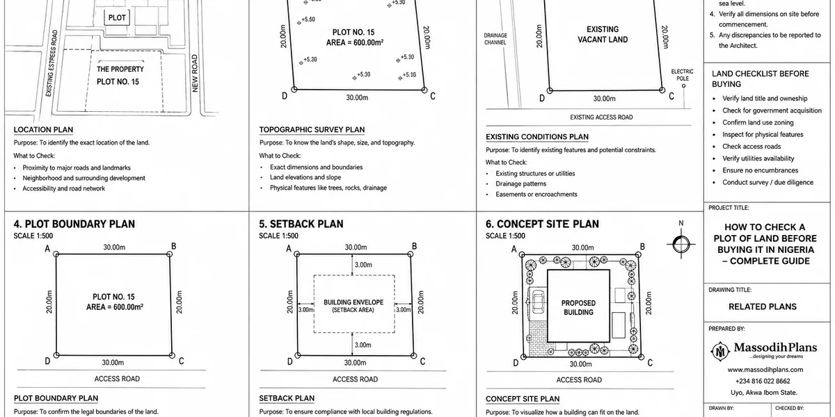
How to Check a Plot of Land Before Buying It in Nigeria: Complete Guide
Buying land in Nigeria is not about finding a plot, agreeing on a price, and transferring money to the seller. The real question is: what exactly are you buying, who has the legal right to sell it, where are its boundaries, and can you develop it? That is why knowing how to check a plot of land before buying it in Nigeria can save you from years of litigation, demolition, boundary disputes, government acquisition, or losing your investment.
In this guide, I will walk you through the checks I would want you to make before paying for any plot, whether you are buying in Lagos, Abuja, Uyo, Port Harcourt, Ibadan, or elsewhere in Nigeria. We will go beyond asking for a C of O or survey plan. You will learn how to examine the seller and chain of ownership, verify land documents, read the survey plan, confirm beacon positions and coordinates, check for government acquisition and planning restrictions, inspect access roads, drainage, topography and surrounding development, and identify problems that may make a cheap plot expensive to build on.
Most importantly, I will show you how to connect the paperwork to the actual ground. A document can look convincing while describing a different parcel, and a physically attractive plot can still have title or planning problems. Recent Nigerian property guidance similarly stresses matching title records, survey information and the physical site rather than trusting documents in isolation.
So, before you pay that deposit, use this guide as your filter. By the end, you will know what to check, who should check it, which red flags should make you stop, and what questions to ask before committing your money.
The Two Ways Land Goes Wrong
Before the checklist, it’s worth understanding that “bad land” comes in two completely different forms, and you need different tools to catch each one.
Legally bad land has a title problem fake or forged documents, a seller who doesn’t actually own it, multiple buyers sold the same plot, or land under government acquisition. This is what a lawyer’s Land Registry search and title verification process is built to catch.
Physically or technically bad land has clean papers but a real-world problem poor soil that inflates foundation cost, a flood-prone low point, no legal access road, a zoning classification that doesn’t permit what you want to build, or a location inside a planned road or drainage reserve that hasn’t been enforced yet. This is what a site visit with the right professional, plus a planning authority check, is built to catch and it’s the category most buyers never think to investigate until they’re already midway through building.
Both categories can independently ruin a purchase. You need to check both.
Before you spend a naira on legal verification, do a rough physical and planning assessment of the land first. It’s faster and cheaper, and it can eliminate an unsuitable plot before you invest in the more expensive legal due diligence process.
Part 1: Legal and Title Verification (The Part Everyone Covers)
I’ll keep this section focused, since detailed document-by-document legal verification deserves and gets its own dedicated treatment. Here’s what has to happen at minimum, and where I’d point you for the deeper legal process.
Confirm the title document type Certificate of Occupancy (C of O), Governor’s Consent, or a Deed of Assignment backed by a valid root of title
Conduct a Land Registry search in the state where the land is located, to confirm the title is genuine and not encumbered by a loan, court case, or prior sale
Verify the survey plan at the Office of the Surveyor-General, confirming it’s genuine and that its coordinates match the actual plot being shown to you
Confirm the seller’s identity and authority to sell for family land, this means getting sign-off from all principal family members, not just one representative; for corporate sellers, verify CAC registration
Check for government acquisition land the state has earmarked for public infrastructure can look completely available for sale while carrying a serious future risk
If your land purchase is high-value, engage a property lawyer for this stage specifically. It’s not the section of this guide worth cutting corners on, and it’s genuinely a different skill set from what I do.
Part 2: Physical Site Verification (Where Most Guides Stop Short)
This is where a plot that passes every legal check can still turn into a construction and financial headache. None of this requires legal expertise it requires actually going to the land with the right eyes, and ideally the right professional.
Boundary and Beacon Verification
A survey plan on paper means little until you confirm its beacons (the physical corner markers) actually exist on the ground and match the plan’s dimensions and coordinates. Engage a licensed surveyor to carry out an independent beacon verification not just a paper search because cases of buyers being shown one plot and later directed to a different, sometimes distant, piece of land are well documented and not rare.
Topography and Flood Risk
Walk the land, ideally after rainfall if you can time it, or ask neighbours directly how the land behaves in the rainy season. Look for:
Whether the plot sits noticeably lower than the surrounding road or neighbouring plots a strong flood indicator
Standing water marks, silt lines, or vegetation patterns that suggest regular waterlogging
Whether nearby drainage channels are functional, blocked, or simply absent
Low-lying plots aren’t automatically unbuildable, but they typically require raised ground levels, more expensive foundation types, and proper drainage engineering costs that should be priced in before you agree a purchase price, not discovered after.
Soil Condition
For any serious purchase, commission a soil test, or at minimum ask around the immediate area about what foundation types nearby buildings have needed. Sandy, waterlogged, or reclaimed land (common in parts of Lagos’s Lekki-Ajah axis and similar coastal areas elsewhere) often needs raft or pile foundations costing significantly more than the strip foundations firmer ground allows. This single factor can shift your total construction budget by millions of naira, and it’s almost never checked before purchase.
Access Road
Confirm there is a legally recognized access road to the plot not just a footpath through a neighbour’s land that happens to be tolerated today. Check the road’s width, whether it’s motorable in the rainy season, and whether it appears on the area’s approved layout plan. Land technically “accessible” only through informal arrangement with a neighbour is a dispute waiting to happen.
Utilities and Services
Check the realistic distance to the nearest power line, and ask directly about water supply borehole feasibility varies significantly by area and water table depth. In areas without public drainage, understand what stormwater management will fall entirely on you to provide.
Never rely solely on the seller’s or agent’s description of soil condition, flood history, or access. Their incentive is to sell, not to flag problems. Independent verification your own site visit, a hired surveyor, and direct conversation with existing neighbours consistently surfaces issues that sellers don’t volunteer.
Part 3: Planning and Zoning Verification (My Actual Specialty)
This is the layer almost no land-buying guide covers at all, because it requires access to and understanding of planning authority records not something most lawyers or real estate agents check by default.
Zoning Classification
Every plot falls under a zoning classification residential, commercial, mixed-use, industrial, or agricultural set by the state’s planning authority or master plan for that area. Land zoned for a use different from what you intend to build can face rejected approval applications regardless of how clean the title is. Confirm zoning directly with the relevant state planning authority (in Lagos, this means checking with the Ministry of Physical Planning and Urban Development or LASPPPA; other states have their equivalent bodies).
Master Plan and Layout Alignment
Beyond zoning, check whether the plot’s boundaries and the surrounding area align with any approved layout or master plan for the location. Land that appears to be a normal residential plot can, in the approved plan, actually be designated as part of a future road widening, drainage channel, or public open space a designation that isn’t always visibly enforced yet but becomes a serious problem the moment you try to get building approval or the moment enforcement eventually catches up.
Setback and Plot Coverage Implications
Confirm the mandatory setbacks and maximum plot coverage that apply to the plot’s zoning and size. A plot that looks generously sized can leave surprisingly little actual buildable area once setbacks are applied this affects whether your intended house size is even achievable on that land, and it’s a calculation worth doing before you commit, not after you’ve paid.
Environmental and Site History Checks
Ask about the land’s prior use. Former dumpsites, waste disposal areas, or land close to industrial activity can carry soil contamination or structural risks that aren’t visible on a normal site visit. This is a less common issue than flooding or drainage, but a serious one where it applies, particularly on the outskirts of rapidly expanding cities where farmland, waste sites, and new residential development sit close together.
Part 4: Neighbourhood and Practical Due Diligence
Talk to People Who Already Live There
Neighbours will tell you things sellers won’t how the land floods, whether there have been disputes over the plot or similar plots nearby, how reliable the access road is in the rainy season, and what the general community relationship with land sales in the area looks like. This is one of the simplest, cheapest verification steps available, and it’s consistently underused.
Assess the Development Pattern Around You
Look at what’s already built nearby. A neighbourhood of half-finished, abandoned structures can signal underlying land or infrastructure problems that aren’t obvious from a single plot visit. Conversely, a steadily developing area with functioning roads, drainage, and occupied buildings is a reasonable proxy for genuine buildability.
Consider Community and Omo Onile Dynamics
In parts of southwestern Nigeria especially, community land touts (commonly called omo onile) can create ongoing “fees” or disputes even after a legitimate purchase. Ask other buyers or residents in the immediate area directly about their experience with this before you commit, since it’s a practical risk that title verification alone won’t reveal.
Part 5: What This Means for Your Building Budget
This is the connection most land-buying guides never make, and it’s the one I think matters most: everything you check in Parts 2 and 3 directly determines what it will cost to actually build on that land.
Poor soil or waterlogged conditions can push foundation costs up by several million naira compared to firm, well-drained ground
Low-lying land may require significant fill and raised ground levels before construction can even begin
Tight setback requirements relative to plot size can force a smaller house than you planned, or push construction toward a second storey to compensate a design and cost decision you’d rather make before buying than after
Distance from existing power infrastructure can mean a costly line extension before you even start building
Absent public drainage means the full cost of stormwater management sits entirely with you
A plot that’s ₦5 million cheaper than a comparable one nearby, but sits on poor soil with no drainage and a tight setback allowance, is very often the more expensive choice once you price in what it takes to actually build there.
Before finalizing any land purchase, get a rough construction feasibility opinion from an architect or engineer not a full design, just an informed read on soil implications, setback impact, and access. It typically costs far less than the mistakes it prevents.
Complete Pre-Purchase Checklist
Legal
- Title document confirmed and Land Registry search completed
- Survey plan verified at the Office of the Surveyor-General
- Seller’s identity and authority to sell confirmed
- Government acquisition status checked
Physical
- Boundary beacons independently verified against the survey plan
- Topography and flood history assessed, including neighbour input
- Soil condition checked or tested
- Legal, motorable access road confirmed
- Realistic power and water access assessed
Planning
- Zoning classification confirmed with the relevant planning authority
- Master plan/layout alignment checked for road, drainage, or public space designations
- Setback and plot coverage implications calculated against your intended house size
- Site history checked for prior contamination-risk uses
Neighbourhood
- Neighbours consulted directly about flooding, disputes, and access reliability
- Surrounding development pattern assessed
- Community/omo onile dynamics inquired about
Frequently Asked Questions
Can land with perfect documents still be a bad purchase?
Yes. Clean legal title only confirms ownership it says nothing about soil condition, flood risk, zoning suitability, or whether the plot’s approved layout designation conflicts with your building plans. Both legal and physical/planning due diligence are needed.
How do I know if land is prone to flooding before the rainy season arrives?
Check whether the plot sits lower than the surrounding road and neighbouring plots, look for silt lines or water marks, and ask neighbours directly how the area behaves during heavy rain this is more reliable than a dry-season visual inspection alone.
Who should I hire to check the physical and planning suitability of land, not just the legal title?
A licensed surveyor for boundary and beacon verification, and an architect or town planner for soil implications, zoning confirmation, and setback/buildability assessment. These are different skill sets from a property lawyer’s title verification role.
Does zoning really matter if the land already has a C of O?
Yes. A C of O confirms occupancy rights, not automatic permission to build whatever you intend. Zoning classification and the area’s approved master plan determine what use and building type the planning authority will actually approve on that plot.
Is cheaper land ever more expensive in the long run?
Frequently. Land priced below comparable nearby plots often carries a hidden cost poor soil, flood risk, or restrictive setbacks that shows up later as increased construction cost, exactly the connection Part 5 above walks through.
Conclusion
Verifying a plot of land in Nigeria properly means checking two entirely different things: whether the seller actually has the legal right to sell it, and whether the land itself is physically and legally suitable to build the house you’re planning. Most guides only walk you through the first. The second soil, topography, drainage, zoning, and setback implications is where I’ve watched otherwise careful buyers get caught out, because it requires a site visit and a planning-authority check that nobody thinks to do until the building approval stage, by which point the land is already paid for.
Do both halves before you pay, not after. If you’re at the design stage once your land is secured, browse our Plans Library for house plans suited to different plot sizes and soil conditions, or visit Plan School to understand how site conditions shape a workable design. Our Services page outlines how we support clients with site assessment and design from land purchase through to building approval, and you can explore more land and building guides on our Homepage.
Related Posts
- How to Choose the Right Land for Building a House in Nigeria Safely Today
- How Much Does It Cost to Build a House in Nigeria? Full Guide to Materials, Labour, Foundation, Roofing and Finishing
- Roofing Quantity Calculator: Calculate Roofing Sheets, Timber, Nails, Ridge Caps and Accessories From Your House Plan
- Labour Cost to Build a House in Nigeria: Complete Mason, Carpenter, Plumber, Electrician and Finishing Cost Guide
- How to Draw a Neighbourhood Plan (SPAR): Step-by-Step Guide to Roads, Plots, Land Use, Setbacks and Layout Design
- How to Draw a House Layout Plan: 10 Step-by-Step Guide From Plot Dimensions to Rooms, Doors, Windows and Setback
- Semi-Detached House Plans: Modern Duplex and Bungalow Designs With Shared Walls, Dimensions, Costs and Layout Ideas
- Courtyard House Plans: Beautiful 2–6 Bedroom Designs With Private Outdoor Spaces, Floor Plans and Dimensions
- Contemporary House Plans: Modern 2–6 Bedroom Designs With Open Layouts, Large Windows, Dimensions and Costs
- House Finishing Cost in Nigeria: Complete Breakdown of Tiles, Painting, Ceiling, Doors, Plumbing and Electrical Work
- Foundation Cost Calculator: Estimate House Foundation Cost From Soil Type, Dimensions, Materials and Labour
- Block Quantity Calculator: How to Calculate the Number of Blocks Needed for Any House From Your Floor Plan
- Cement Quantity Calculator for Building: Calculate Bags Needed for Foundation, Blockwork, Slab, Plastering and Screeding
- Self-Contained House Plans: 15 Efficient Designs With Room Dimensions, Floor Plans, Building Costs and Ideas
- 1 Bedroom House Plan: Affordable Self-Contained Floor Plans With Dimensions, Materials, Cost and Space-Saving Ideas
- 6 Bedroom House Plans: Modern Nigerian Floor Plans With Dimensions, Ensuite Rooms, Parking and Cost Estimates
Author
Massodih Okon is a Nigerian built-environment professional with academic and professional experience in urban and regional planning, geography, architectural design, Landscape Design, GIS and land development.
He holds a Master’s degree in Urban and Regional Planning from the University of Uyo and a first degree in Geography and Regional Planning.
Through MassodihPlans, he publishes practical guides on Nigerian house plans, building design, physical planning, site planning, development approval and residential construction. Read the full author profile →