The Invisible Map That Now Decides Where You Can (and Can’t) Build

Each layer tells a different story. Together, they tell the truth about a piece of land
The question is “what is GIS and why does it matter for my land,” here’s the direct answer: GIS (Geographic Information System) is the digital mapping technology that lets planners layer multiple types of information flood risk, soil type, existing roads, population density over the same piece of land at once, so decisions that used to take months of manual survey work now take days, and catch risks that paper maps used to miss entirely. If you own land or plan to build, there’s a good chance GIS has already quietly assessed your plot, whether you’ve heard of it or not.
I remember the first time I watched a senior colleague pull up a site on a GIS system and instantly flag it as sitting partly within a floodplain something the physical site visit alone had not revealed. That single overlay saved a client from a decision that would have cost him everything he’d invested. This article breaks down, in plain language, what GIS actually is, how it works, and why it now sits at the center of modern planning decisions everywhere in the world.
What Is GIS, Really?
Strip away the jargon, and GIS is simply this: a system that stores map data in layers, and lets you switch layers on and off, or view them together, over the same location. Instead of one flat paper map, imagine a stack of transparent sheets, each one showing something different:
- One sheet shows roads and property boundaries
- Another shows flood-prone zones
- Another shows soil composition
- Another shows population density
- Another shows existing utility lines
You can view any single sheet alone, or stack several together to see how they interact. That stacking is where GIS becomes powerful it reveals conflicts and risks that are invisible when you only look at one layer at a time.
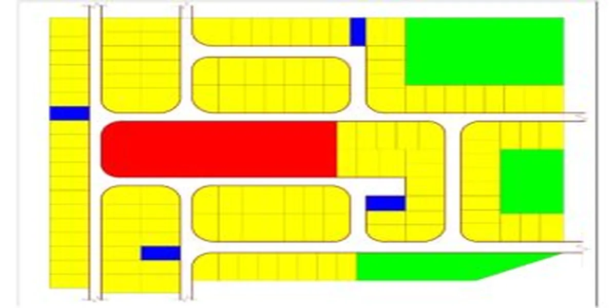
Image suggestion: A layered digital map graphic showing translucent overlays roads, flood zones, and zoning boundaries stacking over one base map. Alt text: “GIS layered mapping showing overlapping planning data.” Caption: “Each layer tells a different story. Together, they tell the truth about a piece of land.”
How GIS Data Is Actually Collected
People often assume GIS data appears out of thin air. It doesn’t. It’s built from real, verifiable sources:
- Satellite and aerial imagery: capturing land cover, vegetation, and built-up areas
- Survey data: precise boundary and elevation measurements taken on the ground
- Government records: land titles, zoning designations, existing infrastructure maps
- Sensor and monitoring data: rainfall gauges, water levels, traffic counts
- Census and demographic data: population figures tied to specific geographic areas
During my training, I learned that GIS is only as trustworthy as the data feeding it. A beautifully designed GIS map built on outdated or incomplete records can still mislead a planner the technology doesn’t fix bad data, it just displays it more convincingly.
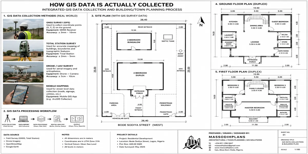
How GIS Data Is Actually Collected
Why GIS Changes Land Use Planning
Land use distribution used to rely heavily on physical site visits and manual measurement. With GIS, a planner can assess an entire region’s land use pattern residential, commercial, agricultural, protected in one sitting, and spot imbalances instantly. In one project I worked on, a GIS layer revealed that a proposed residential expansion overlapped almost entirely with an area already designated for agricultural protection something that would have taken weeks to uncover through manual cross-referencing of paper records.
GIS and Zoning Hierarchy
Zoning becomes far easier to enforce and visualize with GIS. Instead of officials manually checking each application against a written zoning code, a GIS system can instantly show whether a specific plot falls within a residential, commercial, or restricted zone, and flag any overlay restrictions flood risk, heritage protection, environmental buffers attached to it.
Circulation Systems and Road Hierarchy Through GIS
Road networks are one of the clearest use cases for GIS. Planners can model traffic flow, test how a new road connects to the existing arterial-collector-local hierarchy, and simulate congestion before a single road is built. This is not just theory. I have seen it happen: a proposed access road that looked fine on a hand-drawn layout was shown, through GIS traffic modeling, to create a dangerous bottleneck at its junction with the main road a problem caught on screen instead of in real traffic months later.
Plot Arrangement and Physical Planning Standards
GIS allows planners to check setbacks, plot coverage, and density standards across an entire layout simultaneously, rather than plot by plot. If a proposed subdivision has plots that violate minimum frontage or setback rules, GIS analysis flags them before construction, not after a building has already gone up in the wrong place.
Infrastructure Planning: Seeing the Whole System at Once
Utility companies and planners use GIS to map water mains, electricity distribution, and sewage networks as interconnected systems, rather than isolated lines on separate maps. This makes it possible to identify, before any digging starts, which properties would be affected by a new connection, and where existing infrastructure has spare capacity versus where it’s already overloaded.
Flood Control and Drainage: Where GIS Saves the Most Money
This is, in my experience, the single most valuable use of GIS in planning. By overlaying elevation data, historical rainfall records, and existing drainage channels, GIS can model exactly how water will move across a site during heavy rainfall before construction begins. I have worked with clients who wanted to build directly on a natural depression that “looked fine” during a dry-season site visit. A basic GIS flood model would have shown, in minutes, that the same spot sits directly in a stormwater catchment path.
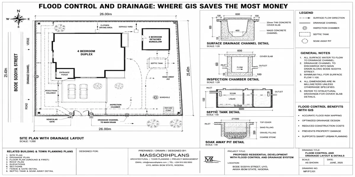
Flood Control and Drainage: Where GIS Saves the Most Money
Environmental Management and Open Space Allocation
GIS makes it possible to track green space, wetlands, and protected vegetation across an entire region and monitor how much is lost to development over time. Environmental agencies increasingly use this data to hold developers accountable to conservation commitments made at approval stage.
Development Control and Approval Processes
Many modern planning authorities now run applications through GIS-based review systems, where a submitted site plan is automatically checked against zoning, flood risk, and infrastructure layers before a human reviewer even looks at it. This speeds up approval for compliant applications and quickly flags problematic ones. A practical lesson from my internship was watching how much faster clean applications moved once departments adopted digital GIS screening compared to purely manual review.
Population Projections and Urban Growth Strategy
GIS combined with census data lets planners model where population growth is likely to concentrate, and test different growth strategies against existing infrastructure capacity showing, for example, whether a district can absorb higher density without overwhelming its road network or water supply.
Smart Growth Through Spatial Analysis
Smart growth strategies depend on directing development toward areas that already have infrastructure capacity, rather than sprawling into unserved land. GIS makes this analysis concrete by overlaying infrastructure capacity maps against vacant or underused land, highlighting the most efficient locations for new growth.
Global Reality Layer: How GIS Is Used Around the World
The core technology is the same everywhere, but how deeply it’s embedded into official planning systems varies by country:
In Nigeria
State ministries and land bureaus are increasingly adopting GIS for land administration and title verification, though adoption levels and data completeness still vary significantly between states.
United States
GIS is deeply embedded at municipal and county level, often publicly accessible through online zoning and parcel-viewer portals that residents can search directly.
Canada
Provinces and municipalities maintain integrated GIS parcel and zoning databases, frequently linked to public property information systems.
United Kingdom
Ordnance Survey data underpins much of the country’s planning GIS infrastructure, feeding into Local Plan mapping and flood risk assessment tools.
Australia
State governments run comprehensive GIS spatial data platforms, widely used for bushfire risk, flood mapping, and zoning verification.
Switzerland
Cantonal GIS systems are tightly integrated with land registry data, supporting the country’s strict zoning between building and non-building land.
Germany
Geoportals operated at federal and state level provide detailed GIS access to zoning, environmental, and cadastral data.
Norway
National mapping authority Kartverket maintains a comprehensive GIS infrastructure feeding directly into municipal planning processes.
New Zealand
Regional councils use GIS extensively for hazard mapping, particularly around flood and earthquake risk, integrated into Resource Management System decisions.
Netherlands
Given the country’s flood management history, GIS is deeply integrated into water management and spatial planning, feeding directly into the bestemmingsplan process.
Sweden
National geodata platforms support municipal detailed planning, with strong integration between GIS and environmental data.
Denmark
A highly digitized national geodata infrastructure supports local planning departments with real-time GIS access.
Ireland
GIS underpins the national planning application system, with mapping data increasingly available to the public through online portals.
Luxembourg
A national geoportal integrates cadastral, zoning, and infrastructure GIS data for a country where land efficiency is a priority.
Austria
State-level geoportals provide GIS access supporting municipal zoning and building permit processes.
Singapore
One of the most advanced systems globally; the Urban Redevelopment Authority integrates GIS deeply into its Master Plan updates and public information platforms.
Belgium
Regional geoportals (Flanders, Wallonia, Brussels) each maintain GIS infrastructure supporting zoning and environmental planning.
France
The Géoportail national platform integrates cadastral and zoning GIS data supporting the PLU process at municipal level.
United Arab Emirates
Development authorities use advanced GIS platforms to manage large-scale master community planning and infrastructure coordination.
Finland
National land survey GIS data feeds into municipal detailed planning with high public data transparency.
South Africa
Municipalities increasingly use GIS to support Spatial Development Frameworks, though data quality and system integration vary by region.
Regardless of a country’s technology level, the underlying value of GIS is identical everywhere: it turns invisible risk into visible information, before money is committed to land.
Human Lifestyle Layer
For an ordinary family, GIS is the reason a new school gets built where children actually live, the reason a road gets widened before congestion becomes unbearable, and the reason some plots quietly get flagged as unsuitable for housing long before anyone breaks ground there. Most people never see the map. They only feel its effects good or bad.
Construction Experience Layer
On projects I’ve worked on, the earliest and cheapest GIS check before any design work starts has consistently saved more money than any single design decision made afterward. Once a foundation is poured on a floodplain or over a utility corridor, no amount of skilled construction fixes that mistake.
Investment Layer
For property developers, GIS-informed due diligence is quickly becoming standard practice, not a luxury. Land that has been cleared against flood, environmental, and zoning layers carries dramatically less risk and holds its value far better than land bought purely on the strength of a physical site visit and a handshake.
Mistakes to Avoid
- Relying only on a physical site visit and skipping flood or hazard layer checks
- Assuming all GIS data is automatically current or complete
- Ignoring zoning overlays that don’t show up on a basic site sketch
- Treating GIS output as a final decision rather than one input among several
- Buying land without requesting any available GIS or hazard mapping report
Quick Summary
GIS layers multiple types of location data flood risk, zoning, infrastructure, population over the same land, revealing conflicts and risks that manual, paper-based methods often miss. It doesn’t replace planning judgment, but it makes that judgment faster, more accurate, and far harder to get wrong.
Frequently Asked Questions
Do I need to understand GIS software myself to benefit from it?
No you simply need to ask your planner or the relevant authority whether GIS-based flood, zoning, or hazard data exists for your plot before you buy or build.
Is GIS data always accurate?
It’s only as accurate as the underlying data feeding it, which is why cross-checking GIS output against a physical site visit and official records is still good practice.
Can GIS predict flooding with certainty?
It models probability based on elevation, historical rainfall, and drainage data it significantly reduces risk and improves decision-making, but it isn’t an absolute guarantee against every possible event.
Is GIS only useful for large-scale developers?
No, even a single landowner benefits enormously from a basic GIS check before committing to a plot, since the same flood, zoning, and infrastructure risks apply regardless of project size.
Conclusion
GIS has quietly become one of the most important tools in modern planning not because it replaces experienced judgment, but because it gives that judgment far better information to work with. Before you commit to a plot anywhere in the world, ask whether GIS data exists for it. That one question can save you from a mistake no amount of good architecture can fix afterward.
If you’re evaluating land and want a plan matched to your zoning and site conditions, browse the MassodihPlans Plans Library. Need a custom assessment or site-specific plan? Explore MassodihPlans Services. New to planning concepts like this? MassodihPlans Plan School breaks it down simply, and the Homepage has everything else MassodihPlans offers.
Complete this lesson by reading the following articles below:
- GIS Applications in Urban Planning: Real-World Examples That Work
- How to Verify Land Ownership Using GIS and Survey Records
- Town Planning Services: Plans, Permits and Land Development
- Master Plan vs Site Plan: Key Differences Every Property Owner Must Know
- Estate Layout Plan Explained for Property Developers and Landowners: Complete Guide
- What Is a Beacon Number on a Survey Plan in Nigeria? Meaning, Uses and Importance
- How to Draw Building Elevations Step by Step (Manually and in AutoCAD): Complete Guide for Beginners
- How Much Money Do You Need to Build a House in Nigeria from the UK, USA or Canada?
- I Need a House Plan That Fits My Plot with Exact Dimensions and Layout
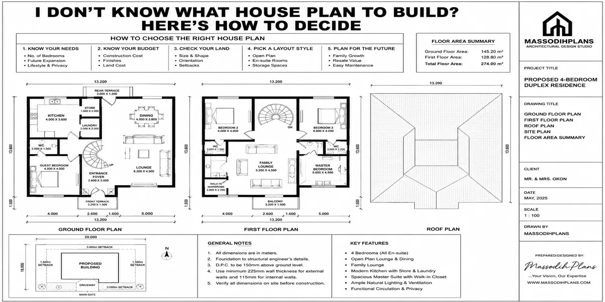
- I Don’t Know What House Plan to Build? Here’s How to Decide
- Landscape Design and Planning for Residential, Estate and Commercial Plans
- Flood Risk Analysis, Flood Mapping and Mitigation Planning for Development
- Land Suitability Analysis and GIS Site Selection for Development Projects
- GIS, Land Use Change Analysis and Digital Mapping for Planning and Growth
- Site Plan Analysis and Layout Planning for Land Development and Building
- Architectural Design and Drafting for House Plans, Building Plans and 3D
- 15 Things to Check Around a Plot Before Buying Land in Nigeria Safely Today
- How to Analyse a Property Location Before Buying Land in Nigeria Today
- How Road Access Affects Residential Building and House Planning in Nigeria
- Best Roofing Options for Houses in Gusau city of Zamfara State, Nigeria: Prices and Durability
Author
Massodih Okon is a Nigerian built-environment professional with academic and professional experience in urban and regional planning, geography, architectural design, Landscape Design, GIS and land development.
He holds a Master’s degree in Urban and Regional Planning from the University of Uyo and a first degree in Geography and Regional Planning.
Through MassodihPlans, he publishes practical guides on Nigerian house plans, building design, physical planning, site planning, development approval and residential construction. Read the full author profile →