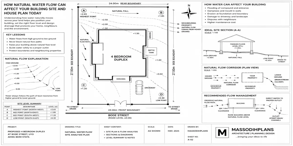
How Natural Water Flow Can Affect Your Building Site and House Plan Today
If you are planning to build a house, a major mistake you can make is to look only at the shape and size of your plot and ignore how water naturally moves across it. Natural water flow can affect major decisions on a building site from where you place the house and entrance to your finished floor level, foundation, driveway, drainage channels, septic system, landscaping and the safety of neighbouring properties.
Think of your land during a heavy rainfall. Water does not care about the building you intend to construct. It follows gravity, moving from higher ground toward lower ground and searching for the easiest route. If your house blocks that route, water may collect around the foundation, wash away soil, enter the compound, damage paving, create damp walls or redirect runoff toward your neighbour.
That is why a well-designed house plan should begin with the site, not be dropped onto it.
In this guide, I’ll show you how to read natural water flow before any construction, identify high and low points, understand contours and site levels, choose safer building positions, determine floor levels, and plan drains, swales, gutters, culverts and discharge points. I will also explain what can happen when a building is placed across a natural drainage path and how a good site plan can prevent expensive problems later.
If you are a homeowner, student, architect, town planner, surveyor or developer, the goal is simple: understand where the water wants to go before carefully deciding where your building should go. Ultimately, you should be able to look at a site plan differently and understand why proper site analysis can save money, protect your building and make your project more resilient.
What “Natural Water Flow” Actually Means on a Building Site
Before anything else, it helps to separate the different kinds of water movement people lump together under “drainage,” because each one demands a different response in your design.
Surface runoff is rainwater moving across the ground toward the lowest point it can reach following the natural slope, or contour, of the land. Every site has a contour, even ones that look flat to the eye.
Natural drainage paths are the specific channels — sometimes visible as shallow depressions, sometimes invisible until it rains that surface runoff consistently follows across a piece of land or a neighbourhood. These existed before your plot was fenced and will keep trying to exist after, whether your building respects them or not.
Groundwater and water table refer to water held within the soil itself, at a depth that varies by location and season. A plot can look completely dry on the surface while sitting on a high water table just below your intended foundation depth.
Upstream and downstream flow describes how water arrives at your plot from higher land nearby, and where it continues to once it leaves your plot toward lower land nearby. Your site is rarely the beginning or end of a water flow story it’s usually the middle of one.
Most building guides talk about “drainage” as something you install after the design is finished. Natural water flow is something you read before the design even starts, because it was already there before your plot existed.
Ask the seller or agent one specific question before buying any plot: “Has this land ever flooded, and where does rainwater go from here?” Most people ask about title and survey documents. Almost nobody asks about water and it’s often the more expensive omission.
How to Actually Read Your Site’s Water Flow Before You Design Anything
This is the part that separates informed site selection from guesswork, and it’s genuinely simple to do if you know what to look for.
Visit the Site During or Right After Heavy Rain
This single visit tells you more than any amount of dry-season inspection. Watch where water pools, where it moves fastest, and which direction it travels across the plot. If you’re buying land during dry season and can’t wait for rain, ask the seller directly, ask long-term neighbours, and look for the physical evidence described below.
Read the Physical Evidence Even in Dry Season
Silt lines or discolouration on walls, fences, or vegetation showing where water has previously reached
Depressions or unusually lush, dense vegetation in specific patches, often a sign of a spot that holds moisture longer than the surrounding ground
Erosion channels or exposed roots along a path, indicating where fast-moving water regularly travels
Cracks or unusual settlement in nearby older structures, sometimes a sign of a wet or unstable subsoil condition
Compare Your Plot’s Elevation to Its Neighbours
Stand at your plot boundaries and honestly assess whether your land sits higher, lower, or level with the plots around it and the street. A plot that sits noticeably lower than its neighbours and the road is, by definition, positioned to receive water those higher areas shed this is simple physics, not bad luck.
Check the Neighbourhood’s Broader Drainage Pattern
Walk or drive the surrounding streets after rain if you can. Note where water visibly collects, which roads flood, and where existing drainage channels or culverts run. Your plot’s water behaviour is rarely independent of this bigger pattern it’s one small part of it.
Get a Proper Topographic Survey and Soil Test
Beyond visual inspection, a topographic survey gives you actual contour data for the plot, and a soil test tells you about water table depth and soil permeability. These aren’t optional extras for a serious build they’re the difference between designing from evidence and designing from hope.
Never rely solely on a dry-season site visit to judge a plot’s water behaviour. If you cannot visit during rainy season before committing to a purchase, insist on a proper topographic and drainage assessment, and speak directly to people who have lived near the plot for several years they will know things no survey document tells you.
How Water Flow Should Shape Your Foundation Choice
Once you understand how water moves across and beneath your site, it directly informs one of the most expensive decisions in your entire build: the foundation.
On a site with a high water table or poor drainage, a standard strip foundation is at real risk of moisture ingress, gradual settlement, and long-term structural stress. This is where raft or pile foundations, though more expensive upfront, are not over-engineering they are the appropriate response to what the land is actually telling you.
On a site along a natural drainage path, even one that’s dry most of the year, foundation depth and damp-proofing need to account for the periodic surge of water the path will carry during heavy rain, not just its average dry-season condition.
On elevated, well-draining sites, a standard foundation approach is usually appropriate, and this is where a soil test earns back its cost many times over by confirming you don’t need to over-spec a foundation your land doesn’t require.
The mistake I see most often isn’t choosing the wrong foundation type it’s choosing a foundation type before anyone has actually studied the site’s water behaviour, then discovering the mismatch only after cracks or damp problems appear months or years later.
How Water Flow Should Shape Your House Plan and Floor Layout
This is the section almost no article on this topic connects properly the relationship between water flow and the actual design of your house plan, not just its foundation.
Building Orientation Relative to the Slope
Where possible, orient the building so its footprint doesn’t sit directly across a natural drainage path position it to the side, allowing water to continue its natural route around rather than through your structure’s zone of influence. Fighting a drainage path by building directly across it usually means fighting it again every rainy season for the life of the building.
Ground Floor Level and Finished Floor Height
The height of your ground floor above the surrounding compound level should be set based on the site’s actual flood risk and water flow pattern, not a generic standard borrowed from a plan designed for a different plot entirely. A site downstream of significant runoff needs a higher finished floor level than a naturally elevated, well-draining site this is a decision your architect should make after seeing your topographic data, not before.
Placement of Water-Sensitive Rooms
Where a site’s water table or flood risk is a genuine concern, think carefully about placing critical service rooms — the electrical distribution point, generator house, or any below-ground storage away from the lowest-lying part of the compound, even if that spot seems structurally convenient otherwise.
Compound Layout and Paving
How you pave your compound directly interacts with natural water flow. Full concrete or heavy paving across the entire compound increases surface runoff volume and speed, often worsening flooding at the compound’s lowest point. Interlocking pavers with permeable joints, or deliberately retained unpaved/planted areas along the natural flow path, let water infiltrate the ground rather than rushing toward your foundation or your neighbour’s plot.
Fence and Gate Design
A solid, ground-level perimeter fence built without any consideration for the site’s natural drainage path can act as a dam during heavy rain, backing water up against your own foundation or redirecting it in ways that create new problems. Small, deliberate drainage openings at the base of a boundary wall, positioned correctly, let water continue its natural path without compromising the fence’s security function.
Ask your architect specifically how the house plan responds to your site’s natural slope and drainage path not just how the foundation was engineered for it. A well-engineered foundation on a badly oriented building is still fighting the land; a building plan that works with the slope needs less engineering to begin with.
What Happens When You Ignore Natural Water Flow
The consequences aren’t hypothetical they’re some of the most common and expensive problems in Nigerian residential construction, and nearly all of them trace back to a site’s water flow being misread or ignored at the design stage.
Foundation dampness and gradual structural stress, from water table or moisture issues never assessed before construction
Recurring compound flooding, from building on or across a natural drainage path without redirecting it properly
Erosion around the foundation or compound edges, from fast-moving surface runoff never accounted for in paving and grading design
Disputes with neighbours, when a building’s grading or paving redirects water flow onto adjoining plots a legal and relational problem, not just a technical one
Reduced property value and resale difficulty, once a documented flooding or dampness history attaches to a property
Expensive retrofit drainage work, which is almost always more disruptive and costly than designing correctly the first time
The Neighbour Dimension: A Responsibility Most Guides Never Mention
Because plots share drainage paths whether their owners acknowledge it or not, your water flow decisions don’t stay on your plot. Raising your compound level, or paving over previously permeable ground, without checking how it changes the water reaching your neighbours, frequently just relocates your flooding problem onto them instead of solving it and this is both an ethical issue and, in many cases, a legal liability.
Before finalizing grading and compound design, it’s worth having an honest conversation, or at minimum a careful site observation, about how your changes will affect the plots immediately around you. This single consideration rare in most building advice is often what separates a design that solves a water problem from one that simply exports it.
Nigeria-Specific Water Flow Realities Worth Knowing
Rainy season intensity in much of Nigeria means water flow volume during a heavy downpour can be dramatically higher than what a site shows on an ordinary day, so any assessment done outside peak rainy months should be treated as incomplete
Low-lying and reclaimed land, common in parts of Lagos and other coastal or riverine areas, often carries genuinely high water tables that demand raft or pile foundations regardless of how the surface appears
Rapid, sometimes informal urban development in many Nigerian cities has altered natural drainage paths faster than infrastructure has adapted to the change, meaning an area’s historical water behaviour may no longer predict its current behaviour reliably recent neighbourhood development matters, not just the land’s old reputation
Drainage easements and road reserves exist specifically to preserve natural or engineered water flow paths, and building or fencing across them is both a design and a regulatory problem, not just a technical inconvenience
A Practical Checklist Before You Finalize Your House Plan
- Has the site been visited during or immediately after heavy rain, or has equivalent evidence been gathered through physical signs and long-term neighbours?
- Does a topographic survey exist showing the plot’s actual contours and slope direction?
- Has a soil test confirmed the water table depth and soil permeability at the actual foundation depth being proposed?
- Does the building’s footprint and orientation work with the site’s natural drainage path, rather than sitting directly across it?
- Has the finished floor level been set based on this specific site’s flood risk, rather than a generic standard?
- Does the compound paving plan balance usability with permeability, rather than defaulting to full hard paving?
- Has the boundary wall design accounted for the site’s drainage path so it doesn’t act as an unintended dam?
- Has the grading and paving plan been checked against its effect on neighbouring plots?
Frequently Asked Questions
How do I know if my land has a water flow problem before I build?
Visit during heavy rain if possible, or look for physical evidence silt lines, unusually lush vegetation patches, erosion channels and compare your plot’s elevation to its neighbours and the street. A topographic survey and soil test give you definitive data beyond visual inspection.
Can I still build on a plot with poor natural drainage?
Yes, in most cases, but it typically requires a more robust foundation type (raft or pile), a raised finished floor level, and a compound design that manages water deliberately rather than assuming it will simply drain away on its own.
Does paving my compound affect flooding on my plot?
Yes. Full hard paving increases the speed and volume of surface runoff instead of letting water infiltrate the ground, which often worsens flooding at your compound’s lowest point and can increase water reaching neighbouring plots.
Is a soil test the same as checking natural water flow?
No. A soil test tells you about the ground’s composition and water table depth beneath the surface. Reading natural water flow also requires understanding surface slope, drainage paths, and how water moves across and around your plot both are necessary, not interchangeable.
Who is responsible if my building’s drainage design floods a neighbour’s plot?
This varies by circumstance and is ultimately a legal question, but responsibly designed grading and drainage that accounts for neighbouring plots from the outset is the practical way to avoid ever having to find out.
Conclusion
Every plot of land has already decided, long before you arrived, where water wants to go. Your job and your architect’s job isn’t to fight that decision with bigger drains and taller walls after the fact. It’s to read it correctly at the very start, and let your foundation, your orientation, your floor levels, and your compound design work with it instead of against it. The client I mentioned at the start eventually rebuilt his floor level and re-graded his compound to work with the land’s natural flow rather than against it at a cost several times higher than if that conversation had simply happened before he broke ground the first time.
If you’re at the site-selection or planning stage, our Services page covers how we assess a site’s water flow and drainage before design begins, not after problems appear. Browse our Plans Library for house plans designed with realistic Nigerian site conditions in mind, or visit Plan School to understand the site assessment process before you commission a design. You can also explore more site planning and building guides on our Homepage.
Related posts
- How Drainage Should Influence Your House Site Planning in Nigeria Today
- How Topography Influences Flooding Around Nigerian Homes and Cities Today
- How to Understand Land Use Before Buying Property in Nigeria Safely
- How Land Use Affects the Type of Building You Can Develop in Nigeria Today
- 10 Things to Check Before Building a House on Any Plot in Nigeria Today
- How to Evaluate Land in Lagos Before Choosing a House Plan to Build Safely (15 Best Ways)
- How to Choose the Right Residential Location in Abuja Before You Build (20 Best Areas Ranked for Buildability)
- How to Choose the Right Residential Location in Lagos Before You Build
- 10 Best House Plans for Small Plots in Nigeria: What Buyers Should Consider
- How to Choose the Right House Plan Based on Your Plot Size in Nigeria Today
- How GIS Can Help You Choose the Right Land for Your Dream House in Nigeria
- How to Identify Flood Risk Before Building a House in Nigeria Today, Safely
- How to Analyse a Building Site Before Choosing a House Plan in Nigeria
- How to Check a Plot of Land Before Buying It in Nigeria: Complete Guide
- How to Choose the Right Land for Building a House in Nigeria Safely Today
- How Much Does It Cost to Build a House in Nigeria? Full Guide to Materials, Labour, Foundation, Roofing and Finishing
Author
Massodih Okon is a Nigerian built-environment professional with academic and professional experience in urban and regional planning, geography, architectural design, Landscape Design, GIS and land development.
He holds a Master’s degree in Urban and Regional Planning from the University of Uyo and a first degree in Geography and Regional Planning.
Through MassodihPlans, he publishes practical guides on Nigerian house plans, building design, physical planning, site planning, development approval and residential construction. Read the full author profile →