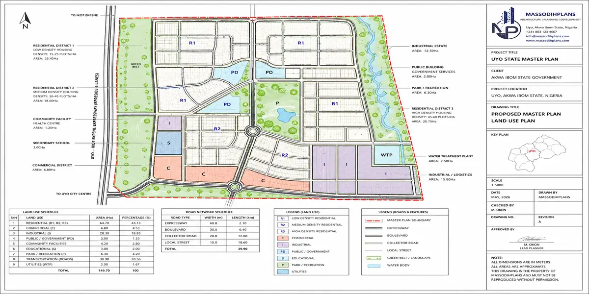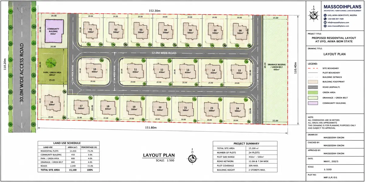
Urban Planning & Urban Design Guide to City Planning, Zoning and Land Development
Introduction to Urban Planning & Urban Design: Complete Guide to City Planning, Zoning and Land Development
Urban planning is the professional process of deciding how land within a city or region is used, organized, and developed, covering everything from zoning and infrastructure to master plans and urban design, so that growth happens in a coordinated, livable, and sustainable way rather than by accident. Urban design, closely related but distinct, shapes the physical experience of that growth: the streets, buildings, and public spaces people actually move through every day. Together, these two disciplines determine whether a city functions well or simply sprawls.
Most guides treat this subject as a dry list of definitions, planner versus designer, zoning versus master planning, without ever connecting the pieces into a working system. This guide is different. It walks through the entire chain, from the first policy decision at city level down to the building permit on a single plot, showing exactly how each stage feeds into the next: how a master plan sets direction, how zoning enforces it, how site planning executes it, and how development control keeps it honest once construction begins.
What sets this guide apart is perspective drawn from active field practice across Nigeria’s South-South region, where planning theory constantly meets real infrastructure limits, informal growth pressure, and approval systems that do not always behave the way textbooks describe. Alongside international examples from Curitiba, Singapore, and Barcelona, this guide grounds every concept in how planning actually plays out on the ground, not just how it is meant to work on paper.
Whether you are a student, a developer, or simply trying to understand your own city better, this is the complete reference to how urban planning and urban design actually build the places we live in.
What Is Urban Planning?
Urban planning is the professional discipline concerned with organizing how land is used, how buildings and infrastructure are arranged, and how people move through and live within a city, town, or region. At its core, urban planning is about decision-making deciding where homes should be built, where roads should run, where markets, schools, hospitals, and industries belong, and how a settlement should grow over the next five, ten, or fifty years. It is both a technical profession and a public responsibility, blending law, engineering, economics, environmental science, and design into a single coordinated process aimed at making cities function well for the people who live in them.
Every city, whether it is a sprawling metropolis like Lagos or a small emerging town in Akwa Ibom State, grows according to some pattern. That pattern can be accidental driven by unplanned settlement, informal construction, and reactive infrastructure or it can be deliberate, guided by trained planners working from data, land-use maps, and long-term development goals. Urban planning exists to push cities toward the second path. It gives a city planning framework: rules and strategies for organizing land use so that residential neighborhoods, commercial districts, industrial zones, and green spaces do not simply collide with one another but instead work together as one functioning system.
Scope of Urban Planning
The scope of urban planning is broader than most people assume. It is not just about drawing lines on a map or approving building plans. A full urban planning process typically covers land-use planning, transportation and infrastructure planning, environmental management, housing policy, economic development, zoning administration, and public space design. A planner might spend one week analyzing population growth projections for a district and the next week reviewing a proposed shopping complex to check whether it fits the surrounding neighborhood’s density and traffic capacity. This is why urban planning is often described as a systems discipline it constantly balances competing demands: growth versus conservation, density versus open space, private development versus public interest.
History of Urban Planning
Historically, the field emerged as a direct response to the problems of unregulated urban growth. During the industrial era, rapid, unmanaged expansion in cities led to overcrowding, poor sanitation, inadequate housing, and disease outbreaks. Public health crises pushed early city planning into a governmental function, with municipalities providing water, sewers, and roads while also introducing regulations for how and where building could occur. Over time, the profession broadened its purpose from crisis management into a proactive tool for shaping equitable, sustainable, and efficient urban futures, according to the University of Iowa’s School of Planning and Public Affairs. That evolution is why modern urban planning today addresses issues such as affordable housing, sustainable land development, climate resilience, and mobility, not merely road layouts and drainage lines.
Scale of Operation
In practical terms, urban planning operates at several scales at once. At the regional level, it deals with how multiple towns and cities relate to one another where new settlements should expand, how regional transport corridors connect them, and how shared resources like water catchments or agricultural land are protected. And at the city level, it produces master plans and structure plans that guide land use across the entire municipality for a set planning horizon, often 15 to 25 years. At the neighborhood and site level, it becomes far more detailed, involving zoning regulations, plot ratios, setback requirements, and development control standards that determine exactly what can be built on a specific parcel of land.
Understanding Urban Planning
A useful way to understand urban planning is to think of it as the science of anticipating consequences. A planner does not simply respond to what a city looks like today; the work is fundamentally about forecasting what a city could become if current land-use trends, population growth, and infrastructure investments continue unchecked, and then intervening early enough to steer that trajectory. This is why urban planning relies heavily on data census figures, land-use surveys, environmental assessments, and infrastructure capacity studies to justify decisions that will shape a community’s physical form for generations.
Distinction Between Urban Planning and Architecture
It is also important to recognize what urban planning is not. And it is not architecture, although it works closely with architects. It is not civil engineering, although it depends on engineering input for infrastructure delivery. And it is not the same as urban design, even though the two are frequently used interchangeably in everyday conversation. Urban planning sets the framework the land-use policies, zoning categories, and development regulations within which architecture and urban design then operate. Where a planner might decide that a particular corridor should be zoned for mixed-use, medium-density development, an urban designer or architect later determines exactly how the buildings, streets, and public spaces within that corridor should look, feel, and function. This distinction matters enormously for anyone trying to understand how cities actually get built, and it is the subject we turn to next.
Understanding urban planning as a foundation is essential before exploring any other part of city development, because every subsequent stage from urban design to land development, master planning, and zoning is built on the planning framework established at this level. A well-planned city is rarely an accident; it is the product of deliberate, informed decisions made by trained professionals working to balance growth, sustainability, and livability. With that foundation in place, the next logical step is to examine urban design specifically: the discipline that takes the broad policies of urban planning and translates them into the physical, sensory experience of the city itself.
What Is Urban Design?
Urban design is the discipline that shapes the physical character, appearance, and experience of the spaces people actually inhabit within a city. Where urban planning sets the broad framework of land use and policy, urban design works within that framework to determine how streets, buildings, public squares, parks, and pedestrian routes come together to create places that feel functional, safe, and attractive. It is the bridge between planning policy and architecture, translating abstract land-use decisions into three-dimensional, human-scaled environments.
If urban planning answers the question of where things should go, urban design answers the question of how those things should look, connect, and feel once they are built. A planner may designate a corridor for mixed-use development; the urban designer then works out the street width, building heights, façade treatment, landscaping, and public realm details that will make that corridor a pleasant, walkable place rather than a disconnected row of structures.
The Core Focus of Urban Design
Urban design concerns itself primarily with the public realm the streets, sidewalks, plazas, parks, and open spaces that belong to everyone rather than to a single property owner. It examines how buildings address the street, how pedestrians move between destinations, how shade, lighting, and seating affect comfort, and how visual continuity is maintained across a neighborhood. Good urban design creates legibility, meaning a stranger can intuitively understand how to navigate a space, find a destination, and feel oriented within it.
Scale and Human Experience
Unlike urban planning, which often operates at the city or regional scale, urban design typically works at the neighborhood, street, or block level. Its central concern is human experience: the width of a sidewalk, the placement of a bus stop relative to shade trees, the rhythm of shopfronts along a commercial street, or the proportion of building height to street width. These details determine whether a place feels welcoming or hostile, safe or exposed, and they have a direct influence on how people use public space, whether they walk, linger, or avoid an area altogether.
Key Elements Urban Designers Work With
Urban design typically addresses several recurring elements: building massing and street frontage, the balance between hard and soft landscaping, pedestrian and cycling networks, public space furniture and lighting, view corridors and landmarks, and the overall visual identity of a district. These elements are usually guided by design codes or urban design frameworks that accompany a master plan, ensuring that individual buildings, even when designed by different architects, still contribute to a coherent overall character.
Connecting Design to Planning Policy
Urban design does not operate independently of urban planning; it is guided by it. Zoning regulations, density allowances, and land-use designations set the boundaries within which urban design decisions are made. A designer cannot simply create any streetscape they wish the building heights, setbacks, and permitted uses are already constrained by the planning framework established earlier in the development process. This is why successful cities depend on close coordination between planners and designers, each contributing a different layer of decision-making toward the same outcome.
Understanding urban design in this way makes clear why it is often confused with urban planning, even though the two disciplines operate at different scales and with different tools. To fully separate these roles and understand how they function together in practice, it helps to compare urban planning and urban design directly, which is exactly what the next section explores.
Urban Planning vs Urban Design
Urban planning and urban design are often used as if they mean the same thing, yet they represent two distinct stages of how a city takes shape. Understanding the difference is essential for anyone trying to make sense of how land gets allocated, how neighborhoods get their character, and who is responsible for which decisions in the development process.
Scope and Scale
Urban planning operates at a broad, systemic level. It deals with entire cities, regions, or districts, and its output is typically policy-based: land-use maps, zoning ordinances, master plans, and infrastructure strategies. Urban design, by contrast, works at a much more focused scale a street, a block, a neighborhood, or a single public square. It takes the broad allocations made by planning and translates them into physical form, deciding how buildings, streets, and open spaces should look and function together.
Decisions vs Experience
Urban planning is fundamentally about decisions: where residential development should occur, how much land should be reserved for commercial use, how transportation corridors should connect different parts of a city, and how growth should be managed over a defined time horizon. Urban design is fundamentally about experience: how a pedestrian feels walking down a street, whether a public square invites people to linger, how building façades relate to one another, and whether a neighborhood has a coherent visual identity. One sets direction; the other shapes perception and daily use.
Tools and Outputs
A city planner typically works with land-use maps, zoning codes, population data, and infrastructure capacity studies. Their outputs are documents and regulations comprehensive plans, structure plans, and zoning ordinances that guide future development. An urban designer works with site plans, streetscape drawings, massing studies, and design guidelines. Their outputs are physical frameworks design codes, public realm strategies, and built environment standards that shape how individual buildings and spaces come together within the zones a planner has already designated.
Who Leads at Each Stage
In a typical development process, urban planning comes first. Planners establish zoning categories, permitted densities, and land-use designations for an area, often through a master plan or local development plan. Urban designers then step in once that framework exists, working within the permitted heights, densities, and uses to craft the physical character of the space how streets are laid out, how buildings meet the sidewalk, and how public spaces are distributed. Architects then design individual buildings within the parameters both disciplines have set.
Why the Distinction Matters in Practice
Confusing the two roles causes real problems in development. A project that ignores planning policy, no matter how well designed, can face rejection during approvals. Equally, a project that satisfies zoning requirements but ignores urban design principles can result in technically legal but poorly functioning spaces disconnected streets, unwelcoming public areas, or inconsistent building character. The strongest developments emerge when planning policy and design intent are coordinated from the outset, with planners defining what is allowed and designers determining how it should feel and function.
Recognizing this relationship between planning and design sets up a natural next question: how does city planning actually work in practice, from the moment a government or agency identifies a need for growth to the point where a finished master plan guides real development on the ground. That process, covering the stages, actors, and tools involved in city planning, is what the next section unpacks.
How City Planning Works
City planning is not a single event but a continuous, multi-stage process that unfolds over years, sometimes decades. It moves through distinct phases, from identifying a need for growth or reform, through data collection and policy formulation, to public consultation, formal adoption, and finally implementation and monitoring. Understanding this sequence explains why planning decisions that affect a neighborhood today were often set in motion long before construction ever begins.
Identifying the Need for a Plan
City planning typically begins with a trigger: rapid population growth, pressure on existing infrastructure, an outdated development framework, environmental concerns, or a government’s economic development agenda. Local or state planning authorities assess whether current land-use patterns and regulations can absorb projected growth, or whether a new plan, or an update to an existing one, is required to guide development more effectively.
Data Collection and Analysis
Before any plan is drafted, planners gather extensive data about the area in question. This includes population statistics, existing land-use surveys, environmental and topographic assessments, transportation patterns, housing stock conditions, and economic activity. This stage establishes the factual baseline for every decision that follows. Without accurate data, a plan risks allocating land or infrastructure in ways that do not match real demand, leading to underused zones or overcrowded districts within a few years of implementation.
Policy Formulation and Land-Use Allocation
Using the data gathered, planners begin allocating land uses across the study area, deciding which zones should be residential, commercial, industrial, institutional, or reserved as green space. This stage also involves setting density targets, identifying transportation corridors, and determining where infrastructure such as water, drainage, and power should be extended. The output is usually a draft land-use plan or structure plan, which becomes the technical backbone of the eventual master plan.
Public Consultation and Stakeholder Engagement
City planning decisions affect real communities, so most planning frameworks require a period of public consultation before a plan is finalized. Residents, landowners, businesses, and community groups review draft proposals and raise concerns about density, traffic impact, land-use conflicts, or displacement risk. This stage is often where plans are adjusted, compromises are reached, and politically sensitive decisions, such as rezoning or land acquisition, are debated openly before adoption.
Formal Adoption and Legal Standing
Once consultation is complete and revisions are made, the plan is submitted to the relevant planning authority or legislative body for formal approval. Upon adoption, the plan typically gains legal standing, meaning future zoning decisions, development permits, and infrastructure investments in the area must align with it. This is the point at which a plan shifts from being a proposal to becoming an enforceable guide for development control.
Implementation Through Zoning and Development Control
A plan on its own does not build anything. Implementation happens through zoning ordinances, building codes, and development control mechanisms that translate the plan’s broad land-use allocations into specific, enforceable rules for individual parcels of land. Every subsequent building permit, subdivision approval, or infrastructure project in the area is evaluated against these rules to ensure it aligns with the adopted plan.
Monitoring, Review, and Revision
City planning does not end at adoption. Planning authorities are expected to monitor how development actually unfolds against the plan’s projections, tracking population growth, infrastructure capacity, and land-use changes over time. Because conditions shift, most plans include a formal review cycle, often every five to ten years, allowing planners to revise land-use allocations, update zoning categories, or expand infrastructure priorities as the city evolves.
Taken together, these stages show that city planning is a deliberate, cyclical process rather than a one-time exercise. Every zoning map, every infrastructure corridor, and every land-use designation traces back to decisions made somewhere along this chain. With this process understood, it becomes easier to see how individual parcels of land move from being part of a citywide plan to becoming an actual building site, which is the focus of the next section: what land development means and how it unfolds in practice.
What Is Land Development?
Land development is the process of transforming raw or underused land into a usable, buildable state, ready to support housing, commerce, industry, or public infrastructure. While city planning sets the policy framework and zoning rules for an area, land development is where those policies meet the ground: surveying, subdividing, servicing, and preparing a physical parcel of land so that construction can legally and practically take place on it.
From Raw Land to Buildable Site
Most land does not start out ready for construction. It may be agricultural, forested, undeveloped bushland, or an informally occupied plot with no infrastructure. Land development bridges that gap, converting land through a sequence of technical and legal steps: acquiring or confirming title, conducting topographic and soil surveys, obtaining planning approval, installing infrastructure, and subdividing the parcel into usable plots. Only after these steps are complete does a piece of land become what developers call a serviced or buildable site.
Key Stages in the Land Development Process
Land development generally follows a recognizable sequence. It begins with site acquisition and due diligence, where a developer verifies land title, ownership history, and any encumbrances. This is followed by feasibility studies, assessing whether the site’s soil conditions, topography, drainage, and location support the intended use. Next comes planning and zoning approval, where the developer confirms the land’s permitted use and density under the local plan and secures the necessary permits. Infrastructure installation follows, bringing in roads, drainage, water supply, electricity, and sometimes sewage systems. Finally, subdivision and titling divide the serviced land into individual plots with registered titles, ready for sale or construction.
The Role of Infrastructure in Land Development
Infrastructure is often the single largest determinant of whether land development succeeds. A plot without road access, drainage, or a reliable water source is far less valuable and far harder to build on safely, regardless of how well it may be zoned. This is why serious land development projects, particularly organized estate layouts, prioritize infrastructure installation early, since retrofitting roads or drainage after buildings have gone up is costly and disruptive.
Land Development and Zoning Compliance
Every stage of land development is shaped by the zoning rules established during the city planning process. A developer cannot simply decide that a parcel should host a shopping complex or an industrial facility; the land’s zoning designation determines what uses are permitted, what density is allowed, and what setbacks, plot coverage, and building heights apply. Development that ignores these rules risks rejection at the approval stage or demolition orders after construction, making zoning compliance one of the earliest and most important checks in any land development project.
Formal vs Informal Land Development
Not all land development follows a formal, planned process. In many fast-growing regions, informal development occurs when land is subdivided and built upon without proper surveys, approvals, or infrastructure planning. While this can provide faster access to housing, it often results in poor drainage, inadequate road access, land disputes, and difficulty securing formal title later. Formal land development, guided by planning authorities and proper documentation, tends to produce more stable, higher-value, and better-serviced neighborhoods over the long term.
Understanding land development as this structured, multi-stage process makes clear why zoning is not a minor bureaucratic detail but a decisive factor shaping what can be built, where, and at what scale. That relationship between zoning regulation and real-world development outcomes is explored in depth in the next section, which looks at how zoning rules actively shape the pace, form, and character of development.
How Zoning Rules Shape Development
Zoning is the regulatory mechanism that translates a city’s land-use plan into legally enforceable rules for individual parcels of land. It determines what can be built where, at what density, and in what form, making it one of the most direct ways planning policy influences everyday development decisions.
What Zoning Actually Controls
Zoning ordinances typically regulate several factors at once: permitted land use, such as residential, commercial, industrial, or mixed-use; density, including plot ratio and units per hectare; building height and setback requirements; and minimum parking or open space provisions. Together, these controls shape not just what type of building can occupy a site, but how large it can be and how it must relate to neighboring properties and the street.
Zoning Categories and Their Purpose
Most cities organize land into broad zoning categories, each with its own permitted uses and development standards. Residential zones prioritize housing density and neighborhood character. Commercial zones allow retail, office, and service uses, often with higher density allowances near transit corridors. Industrial zones separate manufacturing and heavy activity from residential areas to reduce conflict. Mixed-use zones, increasingly common in modern planning, blend residential and commercial uses within the same building or block to encourage walkability and reduce dependence on vehicle travel.
How Zoning Shapes Development Decisions
Developers and property owners must work within the zoning designation already assigned to a parcel before any construction can proceed. A site zoned for low-density residential use, for example, cannot legally host a high-rise apartment block or a factory, regardless of market demand. This constraint shapes land value, project feasibility, and design choices from the earliest planning stages of any project, often before a single drawing is prepared.
Rezoning and Its Implications
When a proposed development does not match a parcel’s existing zoning designation, developers can apply for rezoning, requesting that the local planning authority change the permitted use or density for that site. Rezoning applications typically require justification, public notice, and review against the broader city or master plan, since approving one rezoning request can set a precedent affecting land values and development pressure across an entire district.
Zoning as a Tool for Orderly Growth
Beyond individual projects, zoning functions as a citywide tool for preventing land-use conflicts, protecting neighborhood character, and directing growth toward areas with adequate infrastructure capacity. Without zoning, incompatible uses, such as heavy industry beside residential housing, could develop unchecked, undermining both property values and quality of life.
With zoning established as the regulatory layer guiding individual sites, the next section moves up a level to examine how these zoning categories and land-use decisions are woven together into a single, comprehensive master plan.
Master Planning Explained
A master plan is the comprehensive, long-term framework that coordinates land use, zoning, infrastructure, and development across an entire city, district, or large-scale project. It sits above individual zoning decisions, providing the overarching vision that zoning ordinances and site plans are later designed to implement.
What a Master Plan Contains
A typical master plan includes land-use allocation maps showing residential, commercial, industrial, and green space distribution; infrastructure networks covering roads, drainage, water, and power; population and density projections; and phasing strategies indicating how development should unfold over a defined period, often spanning fifteen to twenty-five years. Some master plans also include design guidelines addressing building heights, streetscapes, and public space standards.
City-Level vs Project-Level Master Plans
Master planning operates at two distinct scales. City-level master plans guide growth across an entire municipality or region, coordinating major infrastructure investments and long-term land-use policy. Project-level master plans apply the same principles at a smaller scale, such as a new estate, university campus, or mixed-use development, organizing internal road networks, plot layouts, and shared facilities within a single, cohesive development.
The Role of Phasing in Master Planning
Because master plans typically cover large areas and long timeframes, they are rarely implemented all at once. Phasing breaks the plan into manageable stages, prioritizing infrastructure and development in areas of highest demand first while reserving later phases for future growth. This staged approach helps developers and government agencies align infrastructure investment with actual population and market growth rather than overbuilding capacity too early.
Master Plans as a Coordination Tool
The core value of a master plan lies in coordination. Without it, roads, drainage, housing, and commercial development can proceed independently and end up misaligned, producing gaps in infrastructure or land-use conflicts. A master plan ensures that when a residential zone is developed, the roads, drainage, and utility networks needed to serve it are planned alongside it, rather than added as an afterthought.
With the citywide or project-wide framework of a master plan established, the next stage in the development process narrows focus considerably, moving from broad land-use coordination down to the design and layout of an individual site, which is where site planning and development come into play.
Site Planning and Development
Site planning is the process of designing the physical layout of an individual parcel of land within the framework already established by zoning and, where applicable, a master plan. It takes the broad allocations of land use and density and translates them into a specific arrangement of buildings, access roads, parking, drainage, and open space on a single site.
What Site Planning Involves
A site plan typically shows building placement and orientation, vehicular and pedestrian access points, parking layout, drainage and stormwater management, landscaping, and utility connections. It also accounts for setbacks, plot coverage limits, and height restrictions inherited from the site’s zoning designation, ensuring the proposed layout complies with local development regulations before construction can proceed.
Site Analysis Before Design
Before any layout is drawn, planners and designers conduct a site analysis, examining topography, soil conditions, drainage patterns, existing vegetation, sun path, and surrounding land uses. This analysis identifies constraints and opportunities specific to the parcel, such as flood-prone areas to avoid, natural slopes that can guide drainage, or existing trees worth preserving. Skipping this step often leads to costly problems later, including drainage failure or poor building orientation.
Balancing Efficiency and Livability
Good site planning balances land-use efficiency with livability. A layout that maximizes the number of buildable plots without accounting for adequate road width, drainage capacity, or open space can produce a congested, poorly functioning development, even if it technically meets zoning density limits. Effective site planning considers how people will move through the site daily, where children will play, how vehicles will circulate, and how stormwater will be managed during heavy rainfall.
From Site Plan to Construction
Once a site plan is finalized and approved by the relevant planning or development control authority, it becomes the reference document guiding subsequent stages: engineering design, infrastructure installation, and individual building construction. Any significant deviation from the approved site plan during construction typically requires a formal amendment and reapproval, since unauthorized changes can violate zoning conditions or infrastructure capacity assumptions built into the original design.
Site planning, in this sense, is where policy and design finally meet the physical realities of a specific piece of land. Having covered how individual sites are planned and developed, the next section zooms back out to examine land-use planning more broadly, looking at how different land uses are categorized, distributed, and balanced across an entire city or region.
Land-Use Planning
Land-use planning is the process of deciding how different parcels of land within a city or region should be allocated among competing uses, such as housing, commerce, industry, agriculture, and conservation. It forms the analytical core of city planning, providing the classification system that zoning ordinances later enforce on individual sites.
Categories of Land Use
Most land-use planning frameworks organize land into broad categories: residential, commercial, industrial, institutional, agricultural, recreational, and conservation or environmentally sensitive areas. Each category carries its own density expectations, infrastructure requirements, and compatibility considerations. Institutional land, for instance, covers schools, hospitals, and government facilities, which require different access and service provisions than a purely residential neighborhood.
Balancing Competing Land Demands
A central challenge in land-use planning is balancing competing demands for limited land. Growing cities face constant pressure to convert agricultural or undeveloped land into housing or commercial space, while also needing to preserve green space, protect watersheds, and maintain agricultural production for food security. Land-use planners weigh these pressures against population projections, economic priorities, and environmental constraints to determine the most sustainable distribution of uses across the available land.
Land-Use Compatibility and Conflict Avoidance
Effective land-use planning also focuses on compatibility, ensuring that adjoining uses do not undermine one another. Heavy industrial activity placed directly beside residential housing can create noise, pollution, and safety concerns, while a well-placed buffer zone or transitional use, such as light commercial or green space, can prevent these conflicts. This is why land-use maps often show gradual transitions between zones rather than abrupt shifts from one use to another.
The Link Between Land-Use Planning and Infrastructure
Land-use decisions directly determine infrastructure demand. A zone allocated for high-density residential development requires significantly more road capacity, water supply, and drainage than a low-density agricultural area. Because of this relationship, land-use planning and infrastructure planning are almost always developed together, with infrastructure investment prioritized in areas designated for growth and scaled back in zones intended to remain undeveloped or low-density.
Land-use planning, in essence, is the strategic layer that decides what a city needs where, based on data, projected growth, and environmental capacity. Because every land-use designation carries direct implications for roads, water, drainage, and transit demand, the next section turns specifically to transportation and infrastructure planning, examining how cities design the networks that connect and service the land uses established at this stage.
Transportation and Infrastructure Planning
Transportation and infrastructure planning determines how people, goods, and essential services move through a city, connecting the land uses established during land-use planning into a functioning, accessible whole. Without well-planned infrastructure, even the most carefully zoned land-use pattern can fail, leaving neighborhoods isolated, congested, or without basic services.
Core Components of Infrastructure Planning
Infrastructure planning typically covers road networks and hierarchy, public transit systems, water supply and distribution, drainage and stormwater management, sewage and waste systems, and power distribution. Each component must be sized and routed according to the density and land use it will serve, meaning a high-density commercial corridor requires far greater road and drainage capacity than a low-density residential street.
Road Hierarchy and Network Design
Transportation planning organizes roads into a hierarchy, typically ranging from major arterial roads that carry high volumes of through-traffic, to collector roads that funnel local traffic toward arterials, down to minor residential streets designed primarily for access rather than speed. This hierarchy prevents heavy traffic from cutting through residential neighborhoods while ensuring efficient movement across the wider city.
Integrating Transit and Land Use
Modern transportation planning increasingly emphasizes the connection between transit availability and land-use density, an approach often referred to as transit-oriented development. Areas well served by public transport are typically planned for higher density, mixed-use development, reducing dependence on private vehicles and easing pressure on road networks. Conversely, areas with limited transit access are generally planned at lower densities, since road infrastructure alone struggles to support high population concentrations efficiently.
Infrastructure Capacity and Growth Sequencing
Because infrastructure is expensive and slow to build, planners sequence its rollout to match projected growth rather than building at full capacity immediately. This is why master plans often include phased infrastructure delivery, prioritizing roads, water, and drainage in areas designated for early development while deferring investment in zones planned for later-stage growth.
Consequences of Poor Infrastructure Planning
When infrastructure planning lags behind land-use decisions, the results are visible in many fast-growing cities: flooding from inadequate drainage, traffic congestion from underbuilt road networks, and unreliable water supply in newly developed neighborhoods. These outcomes underscore why infrastructure and land-use planning must be developed together rather than treated as separate processes.
With land use and infrastructure established as interdependent systems, the next section applies these principles directly to the built environment, examining how residential, commercial, and mixed-use development are planned and organized within the broader city structure.
Residential, Commercial and Mixed-Use Development
Residential, commercial, and mixed-use development represent the primary building blocks through which land-use plans and zoning designations become the actual neighborhoods people live, work, and shop in. Each development type serves a distinct function within a city, yet increasingly, modern urban planning favors blending them rather than keeping them strictly separated.
Residential Development
Residential development covers housing at varying densities, from single-family detached homes to townhouses, low-rise apartments, and high-density residential towers. Planning for residential areas involves balancing density with livability, ensuring adequate access to roads, drainage, schools, and open space. Density decisions here are rarely arbitrary; they typically follow directly from a site’s zoning classification and its position relative to transit, infrastructure capacity, and surrounding land uses.
Commercial Development
Commercial development includes retail centers, office buildings, markets, and service-oriented businesses. Planners typically direct commercial development toward high-visibility, high-accessibility locations, such as major road junctions or transit corridors, where customer footfall and vehicle access are strongest. Commercial zoning also considers parking demand, loading access for goods vehicles, and compatibility with neighboring residential areas, often requiring buffer zones or design controls to limit noise and traffic spillover.
Mixed-Use Development
Mixed-use development combines residential, commercial, and sometimes institutional uses within the same building, block, or district. A typical example places retail or office space at ground level with residential units above, allowing people to live close to daily amenities without heavy reliance on vehicle travel. Mixed-use development has become a central strategy in contemporary urban planning because it increases land-use efficiency, supports walkability, and creates more active, continuously used streets compared to single-use zones that empty out after business hours.
Why the Balance Between These Types Matters
A city’s long-term functionality depends heavily on how well these three development types are balanced and distributed. Too much low-density residential development spread across a wide area increases infrastructure costs and vehicle dependence, while overconcentration of commercial development in a single district can create traffic bottlenecks and underused space elsewhere. Mixed-use development, when applied strategically along transit corridors and neighborhood centers, helps distribute activity more evenly and reduces pressure on any single part of the city’s infrastructure.
Development Type and Zoning Alignment
Every residential, commercial, or mixed-use project must align with the zoning designation already assigned to its site, whether that designation was established through a citywide master plan or a project-specific development plan. Attempting to introduce a use inconsistent with existing zoning typically requires a formal rezoning application, subject to the same review process discussed earlier.
Understanding how these development types are planned and balanced sets the stage for examining how individual projects are actually regulated and monitored once construction begins, which is the focus of the next section on development control.
Development Control
Development control is the regulatory process through which planning authorities monitor, review, and enforce compliance with zoning rules, approved site plans, and building standards once a project moves from proposal to construction. It is the enforcement arm of urban planning, ensuring that what actually gets built on the ground matches what was approved on paper.
The Purpose of Development Control
Without development control, even well-crafted master plans and zoning ordinances would have little practical effect, since nothing would prevent developers from ignoring approved densities, exceeding building heights, or encroaching on setbacks. Development control provides the enforcement mechanism that keeps individual projects aligned with the broader land-use and infrastructure framework established during planning.
Key Functions of Development Control
Development control typically involves reviewing building plans against zoning requirements before construction begins, inspecting sites during construction to confirm compliance with approved plans, and issuing completion certificates once a project meets all required standards. Authorities also monitor for unauthorized construction, illegal land use conversions, and encroachments onto road reserves, drainage channels, or setback areas, since these violations can undermine infrastructure capacity and safety for an entire district.
Common Violations and Their Consequences
Typical development control violations include building beyond approved plot coverage, exceeding permitted height limits, converting a residential property to commercial use without rezoning approval, or blocking drainage rights of way with unauthorized structures. Consequences for violations range from fines and stop-work orders to demolition of non-compliant structures, particularly where safety, drainage, or road access is compromised.
Development Control and Building Permits
Before construction can legally begin, most jurisdictions require developers to obtain a building permit, which confirms that submitted plans comply with zoning, structural, and safety regulations. Development control officers typically conduct staged inspections during construction, checking foundation work, structural elements, and final finishes against the approved plan before authorizing occupancy.
Why Development Control Matters for Long-Term Planning Success
Strong development control protects the integrity of an entire master plan, not just individual sites. A single unauthorized high-rise in a low-density zone, or a factory built beside a residential neighborhood, can undermine years of coordinated planning, straining infrastructure never designed to support it and creating land-use conflicts that are expensive to reverse.
With development control established as the enforcement layer that keeps individual projects aligned with planning policy, the next section examines the front end of that process in more detail, exploring exactly how planning permission and development approvals are obtained before construction can legally proceed.
Planning Permission and Development Approvals
Planning permission is the formal authorization a developer or property owner must obtain from the relevant planning authority before undertaking construction, land subdivision, or a change of land use. It is the procedural gateway through which zoning compliance, site plans, and development standards are verified before any physical work begins.
Why Planning Permission Is Required
Planning permission exists to confirm, in advance, that a proposed project aligns with the zoning designation, density limits, and infrastructure capacity of its location. Rather than allowing construction to proceed unchecked and correcting violations afterward, planning authorities review proposals upfront, reducing the risk of land-use conflicts, infrastructure overload, or unsafe development once building is complete.
The Typical Approval Process
While specific procedures vary by jurisdiction, most planning permission processes follow a similar sequence. The applicant submits site plans, building drawings, and supporting documents such as land title and survey reports to the relevant authority. Planning officers review the submission against zoning regulations, master plan provisions, and building codes. Depending on the project’s scale, the application may also require environmental assessments, traffic impact studies, or public notification. Once satisfied, the authority issues approval, sometimes with conditions attached, before construction can legally commence.
Types of Development Approvals
Developers may need several distinct approvals depending on project type. These commonly include outline or preliminary approval confirming the proposed use is acceptable in principle, detailed planning approval covering full site and building plans, subdivision approval for dividing land into multiple plots, and building permits authorizing actual construction once planning approval is secured. Larger or environmentally sensitive projects may also require separate environmental impact assessments before final approval.
Conditions and Compliance Requirements
Approvals are frequently issued with conditions, such as requirements to provide adequate parking, install drainage infrastructure, set aside green space, or limit building height beyond what was originally proposed. These conditions become legally binding once accepted, and failure to comply can result in approval revocation, fines, or enforcement action under the development control processes described earlier.
Consequences of Building Without Approval
Constructing without proper planning permission exposes developers to significant risk, including stop-work orders, demolition, and difficulty securing formal property title later. Beyond legal risk, unauthorized development often lacks the infrastructure coordination that formal approval processes require, leading to drainage problems, inadequate road access, or unsafe building conditions.
Having established how individual projects gain legal authorization to proceed, the next section shifts focus to areas that already exist but require renewal, examining how urban renewal and redevelopment address aging, deteriorating, or underused parts of a city.
Urban Renewal and Redevelopment
Urban renewal and redevelopment address parts of a city that have declined, become underused, or no longer serve their original purpose effectively. Rather than expanding outward onto new land, this branch of urban planning focuses inward, revitalizing existing built areas to restore their function, safety, and economic value.
What Drives the Need for Urban Renewal
Urban renewal typically becomes necessary when neighborhoods experience aging infrastructure, deteriorating building stock, economic decline, or land uses that no longer match current demand, such as former industrial sites left vacant after factories relocate. Population shifts, changing transportation patterns, and outdated zoning can also leave once-thriving districts underutilized, prompting planning authorities to intervene with renewal strategies.
Approaches to Urban Renewal
Urban renewal can take several forms depending on the severity of decline and the resources available. Rehabilitation focuses on repairing and upgrading existing buildings and infrastructure without full demolition, preserving neighborhood character while improving safety and function. Redevelopment involves demolishing deteriorated structures and rebuilding according to updated plans, often increasing density or introducing mixed-use development where single-use zoning previously limited activity. Adaptive reuse converts existing buildings, such as old warehouses or factories, into new functions like residential lofts, offices, or commercial space, preserving structural and historical value while meeting current market needs.
Balancing Renewal with Community Impact
Urban renewal projects carry significant social implications, particularly when redevelopment displaces existing residents or businesses unable to afford rebuilt properties. Because of this, modern renewal approaches increasingly emphasize community engagement, phased redevelopment, and affordable housing provisions to reduce displacement risk while still achieving the physical and economic goals of renewal.
Infrastructure Upgrades as Part of Renewal
Renewal projects frequently include infrastructure upgrades alongside building work, replacing aging drainage, water, and road systems that were never designed to support current population density. Without this infrastructure component, redevelopment can simply relocate the same capacity problems into newly rebuilt neighborhoods rather than resolving them.
Renewal and the Broader Master Plan
Urban renewal does not happen in isolation; it is typically guided by the same master planning framework covered earlier, with renewal areas identified as priority zones within a city’s long-term development strategy. This ensures redevelopment aligns with citywide land-use goals rather than producing isolated improvements disconnected from surrounding infrastructure and transit networks.
Having examined how cities repair and reinvent their existing built environment, the next section looks forward, exploring how sustainability principles are increasingly shaping the way new urban planning decisions are made from the outset.
Sustainable Urban Planning
Sustainable urban planning integrates environmental, economic, and social considerations into every stage of the planning process, ensuring that growth today does not undermine a city’s resilience, resource availability, or livability in the future. It has moved from being a niche specialty to a core expectation across land-use planning, master planning, and development control.
Core Principles of Sustainable Planning
Sustainable urban planning generally rests on a few consistent principles: reducing land consumption through compact, efficient development; minimizing environmental impact on water, air, and natural ecosystems; promoting energy-efficient infrastructure and buildings; and ensuring development remains resilient against climate-related risks such as flooding, heat stress, and extreme weather events. These principles influence decisions at every scale, from citywide land-use allocation down to individual site drainage design.
Compact Development and Land Efficiency
One of the most consistent strategies in sustainable planning is compact, higher-density development focused around existing infrastructure and transit corridors, rather than continuous low-density expansion into undeveloped land. This approach reduces the cost and environmental footprint of extending roads, water, and drainage networks, while also shortening travel distances between housing, employment, and services.
Environmental Protection in Land-Use Decisions
Sustainable planning places strong emphasis on protecting environmentally sensitive areas, such as wetlands, floodplains, and natural drainage channels, from inappropriate development. Land-use plans increasingly designate these areas as conservation or restricted zones, recognizing that building on them not only damages ecosystems but also increases flood risk and infrastructure failure in surrounding neighborhoods.
Green Infrastructure and Climate Resilience
Modern sustainable planning incorporates green infrastructure, including urban tree cover, permeable surfaces, and constructed wetlands, to manage stormwater naturally while improving air quality and reducing urban heat. These elements are increasingly written into master plans and development approval conditions, particularly in areas prone to flooding or extreme heat, making climate resilience a standard planning requirement rather than an optional addition.
Sustainability and Long-Term Cost Efficiency
Beyond environmental benefits, sustainable planning is increasingly justified on economic grounds. Compact development reduces long-term infrastructure maintenance costs, while resilient design reduces disaster recovery expenses after floods or storms. This economic rationale has helped push sustainability principles into mainstream planning practice rather than treating them as a specialized or optional consideration.
As sustainability becomes embedded across planning practice, it increasingly intersects with technology-driven approaches to city management. The next section explores this intersection directly, examining how smart cities and modern urban design tools are reshaping how planners monitor, manage, and design urban environments today.
Smart Cities and Modern Urban Design
Smart cities apply digital technology, data collection, and connected infrastructure to improve how urban systems function, from traffic management to utility distribution. This approach has become increasingly integrated into modern urban planning and design, adding a technological layer on top of the traditional land-use and infrastructure frameworks covered earlier.
What Defines a Smart City
A smart city typically uses sensors, data networks, and digital platforms to monitor and manage urban systems in real time. This can include traffic sensors that adjust signal timing based on actual congestion, smart water meters that detect leaks before they become major losses, or integrated platforms that help city agencies coordinate emergency response. The defining feature is not the technology itself, but its use to make existing infrastructure and services more efficient and responsive.
Smart Infrastructure and Utility Management
And smart city technology is frequently applied to infrastructure systems established during earlier planning stages, particularly transportation, water, and power networks. Smart traffic systems reduce congestion without necessarily building new roads, while smart grids improve power distribution efficiency and help identify faults faster. These applications extend the value of existing infrastructure investments rather than replacing the underlying planning and engineering work behind them.
Data-Driven Planning Decisions
Beyond managing existing infrastructure, smart city tools increasingly feed data back into the planning process itself. Real-time traffic data, utility usage patterns, and population movement analytics give planners far more precise information than traditional surveys alone, allowing land-use and infrastructure decisions to be based on actual usage patterns rather than static projections.
Modern Urban Design and Technology Integration
Contemporary urban design increasingly incorporates technology directly into the public realm, including digital wayfinding, smart lighting that adjusts based on pedestrian activity, and integrated charging infrastructure for electric vehicles. These elements are typically layered onto the fundamental urban design principles covered earlier, such as walkability and human-scaled streetscapes, rather than replacing them.
Limitations and Practical Considerations
Smart city technology is not a substitute for sound land-use planning, adequate infrastructure capacity, or well-designed public space. Sensors and data platforms can optimize how existing systems perform, but they cannot compensate for poorly planned road networks, inadequate drainage, or zoning decisions that create long-term land-use conflicts. Smart technology works best when layered onto a strong planning and design foundation rather than used to patch over weak fundamentals.
Having covered how technology intersects with contemporary planning and design, the next section broadens the lens further, examining how urban planning practices, regulations, and priorities differ across countries and regions around the world.
Urban Planning by Country
While the core principles of urban planning, land-use organization, zoning, and infrastructure coordination remain broadly similar worldwide, the specific systems, terminology, and levels of government responsible for planning vary significantly from country to country. Understanding these differences helps explain why planning processes that work smoothly in one country can look very different in another.
United States and Canada
In the United States and Canada, urban planning is largely decentralized, with municipalities and local governments holding primary authority over zoning and land-use decisions, guided by state or provincial planning legislation. Zoning ordinances tend to be highly detailed, specifying permitted uses, densities, and design standards at the parcel level, while comprehensive or master plans provide the broader policy framework local zoning must align with.
United Kingdom and Commonwealth Nations
The United Kingdom operates a discretionary planning system, where development proposals are assessed individually against local and national planning policy rather than relying purely on fixed zoning categories. Many Commonwealth nations, including parts of Nigeria, Ghana, and other formerly British-administered territories, inherited elements of this system, blending statutory land-use plans with development control processes that require case-by-case planning permission for most projects.
European Union Countries
Across much of continental Europe, urban planning tends to be more centrally coordinated, with national or regional governments setting strong planning frameworks that local authorities implement. Countries such as Germany, the Netherlands, and the Nordic nations are frequently cited for integrating land-use planning closely with public transit investment and sustainability policy, producing compact, transit-oriented urban form as a matter of standard practice rather than exception.
Nigeria and Sub-Saharan Africa
In Nigeria, urban and regional planning operates through federal, state, and local government structures, with state planning authorities typically responsible for approving layouts, issuing planning permits, and enforcing zoning regulations within their jurisdictions. Many Sub-Saharan African cities face the added challenge of rapid, often informal urban growth outpacing formal planning capacity, making development control and land regularization particularly significant areas of planning practice across the region.
Asia and the Middle East
Rapidly urbanizing countries across Asia and the Middle East, including Singapore and the United Arab Emirates, are frequently highlighted for tightly coordinated, state-led master planning, where government agencies drive large-scale infrastructure and land-use development with strong implementation authority, often producing rapid, highly organized urban growth compared to more fragmented, locally driven systems elsewhere.
These international variations show that while planning tools such as zoning, master plans, and development control are broadly universal, the institutions and processes applying them differ widely. With this global context established, the next section turns to a more practical question: what careers exist within urban planning and urban design, and what paths lead into this profession.
Careers in Urban Planning and Urban Design
Urban planning and urban design offer a range of career paths across government agencies, private consulting firms, real estate development companies, and non-profit organizations. As cities continue to grow and face increasing pressure around housing, infrastructure, and sustainability, demand for trained professionals in this field continues to expand across both the public and private sectors.
Common Career Paths
Within urban planning, professionals typically work as city or town planners in government planning departments, reviewing development applications, drafting zoning ordinances, and preparing master plans. Private sector planners often work for consulting firms, advising developers on land-use feasibility, zoning compliance, and planning approvals for specific projects. Urban designers, meanwhile, frequently work within architecture or design firms, focusing on streetscape design, public space planning, and design guidelines for larger developments or municipal projects.
Educational Pathways
Most urban planning careers require a university degree in urban and regional planning, geography, architecture, or a closely related field, often followed by a specialized postgraduate qualification in planning. Urban design roles similarly draw from architecture, landscape architecture, and planning backgrounds, with many professionals combining formal design training with planning coursework to bridge both disciplines effectively.
Professional Certification and Membership
In many countries, practicing as a registered town planner requires certification or membership with a recognized professional body, such as the Nigerian Institute of Town Planners, the American Institute of Certified Planners, or the Royal Town Planning Institute in the United Kingdom. These bodies typically require a combination of accredited education, supervised professional experience, and examination before granting full membership, and often mandate ongoing professional development to maintain registration.
Specializations Within the Field
As the profession has grown, planners and designers increasingly specialize in specific areas, such as transportation planning, environmental and sustainability planning, housing policy, urban regeneration, GIS and spatial data analysis, or heritage and historic preservation planning. Specialization allows professionals to develop deep technical expertise while still operating within the broader planning and design framework covered throughout this guide.
Career Progression and Practice Settings
Entry-level planners and designers typically begin in supporting roles, such as development application review or drafting, before progressing toward project leadership, policy development, or senior advisory positions. Many experienced professionals eventually move into private practice, consulting directly for developers, government agencies, or international organizations on land-use strategy, master planning, and development feasibility.
Understanding these career pathways naturally leads to a closer look at what the role of an urban planner actually involves day to day, which the next section explores in detail, distinguishing the specific responsibilities and skills that define this side of the profession.
Role of an Urban Planner
An urban planner is the professional responsible for guiding how land is used, developed, and managed within a city, district, or region, working across policy, technical analysis, and public engagement to balance growth with livability, sustainability, and infrastructure capacity. The role sits at the intersection of law, data, and public policy, requiring both technical competence and the ability to navigate community and political interests.
Core Responsibilities
Urban planners typically prepare and update master plans, structure plans, and land-use maps that guide long-term development within their jurisdiction. They draft and administer zoning ordinances, review development applications for compliance with planning regulations, and advise government agencies or private clients on land-use feasibility. Many planners also lead public consultation processes, presenting proposed plans to residents and stakeholders, gathering feedback, and adjusting proposals in response to community concerns before formal adoption.
Working with Data and Analysis
A significant part of a planner’s daily work involves data analysis. Planners study population growth trends, housing demand, traffic patterns, and environmental constraints to forecast future needs and justify land-use decisions. This analytical work forms the evidence base for master plans and zoning changes, ensuring decisions are grounded in measurable trends rather than assumption or political pressure alone.
Coordinating Across Disciplines
Urban planners rarely work in isolation. They coordinate closely with civil engineers on infrastructure capacity, with architects and urban designers on how approved zoning translates into physical form, with environmental specialists on sustainability and climate risk, and with legal advisors on regulatory compliance. This coordinating role makes planners central figures in translating policy intent into buildable, functional development across multiple technical disciplines.
Reviewing Development Applications
A substantial portion of many planners’ time involves reviewing development applications submitted by property owners and developers, checking proposed projects against zoning regulations, density limits, and infrastructure capacity. This process, closely tied to the development control functions discussed earlier, requires planners to interpret regulations accurately and consistently, since decisions at this stage directly affect what gets built and where.
Public Engagement and Policy Advocacy
Beyond technical analysis, planners often serve as intermediaries between government policy and public interest, explaining proposed changes to residents, addressing concerns about density or displacement, and advocating for policies that balance growth with community wellbeing. This public-facing responsibility distinguishes urban planning from more purely technical professions, requiring strong communication skills alongside technical expertise.
Skills That Define the Role
Effective urban planners typically combine strong analytical and data skills with knowledge of planning law and zoning regulation, familiarity with geographic information systems, and the communication ability needed to engage both government officials and the general public. Many also develop specialized expertise over time in areas such as transportation planning, environmental policy, or urban regeneration.
Having examined the planner’s role in detail, the next section turns to the closely related but distinct role of the urban designer, exploring how their responsibilities differ in focus, scale, and daily practice.
Role of an Urban Designer
An urban designer focuses on the physical and spatial quality of the built environment, translating the land-use and zoning framework established by planners into streets, public spaces, and building arrangements that function well and feel coherent to the people who use them. While planners set the rules, designers shape the lived experience within those rules.
Core Responsibilities
Urban designers typically develop design guidelines and urban design frameworks that accompany master plans, specifying how streetscapes, building frontages, and public spaces within a district should be organized. They prepare detailed drawings and three-dimensional studies showing how proposed buildings relate to streets and neighboring structures, and they often review individual development proposals for design quality, even where those proposals already comply with zoning regulations on paper.
Designing the Public Realm
A central responsibility of urban designers is shaping the public realm, the streets, sidewalks, plazas, and parks that belong to the community rather than individual property owners. This involves decisions about street width, sidewalk treatment, street furniture, lighting, and landscaping, all aimed at creating spaces that are safe, comfortable, and encourage pedestrian activity rather than spaces dominated purely by vehicle movement.
Working with Architects and Developers
Urban designers frequently collaborate with architects and developers during the early stages of a project, helping ensure that individual buildings contribute positively to the surrounding streetscape rather than functioning as isolated structures. This can involve guidance on building height transitions, ground-floor activation through retail or residential entrances, and how a proposed building’s massing relates to neighboring properties and public space.
Balancing Design Vision with Regulatory Constraints
Because urban designers work within the zoning and density limits established by planners, much of their skill lies in achieving strong design outcomes within fixed regulatory boundaries. A designer cannot simply propose an ideal streetscape without regard for permitted building heights or setback requirements; instead, they must find creative solutions that satisfy both regulatory compliance and genuine design quality.
Skills That Define the Role
Effective urban designers typically combine strong visual and spatial reasoning with technical drawing skills, an understanding of zoning and planning regulations, and knowledge of how the built environment influences pedestrian behavior and public safety. Many urban designers come from architecture or landscape architecture backgrounds, supplemented with specific training in urban design theory and practice.
Having distinguished the planner’s and designer’s roles in detail, the next section brings these concepts together through real examples, examining specific urban planning and design projects from around the world.
Urban Planning Examples Around the World
Examining real cities and projects helps translate the concepts covered throughout this guide, land-use planning, zoning, master planning, and urban design, into tangible outcomes that demonstrate how planning decisions shape everyday urban life.
Curitiba, Brazil
Curitiba is frequently cited as a model of integrated transportation and land-use planning. Rather than building costly rail infrastructure, the city developed a bus rapid transit system closely coordinated with zoning policy, directing higher-density development along transit corridors while limiting density in areas without transit access. This alignment between infrastructure and land use allowed the city to manage rapid population growth without the severe congestion seen in many comparably sized cities.
Singapore
Singapore illustrates state-led master planning at a national scale. With limited land area, the government has relied on long-term master plans updated on a regular cycle, coordinating housing, transportation, and industrial land use through strong centralized planning authority. Public housing estates are deliberately planned with integrated commercial, recreational, and transit facilities, reflecting the mixed-use principles discussed earlier in this guide.
Barcelona’s Superblock Model
Barcelona’s superblock initiative demonstrates urban design applied at the neighborhood scale to reclaim street space from vehicle traffic. By restricting through-traffic within designated street grids, the city converted former traffic corridors into pedestrian-friendly public space, directly applying the public realm and walkability principles central to modern urban design practice.
Abuja, Nigeria
Abuja’s development as Nigeria’s federal capital reflects large-scale master planning applied to an entirely new city built largely from a single comprehensive plan. Its structured land-use zones, wide arterial road network, and planned district layout contrast with the more organically grown pattern typical of older Nigerian cities, illustrating how master planning shapes urban form when applied from the outset rather than retrofitted onto existing development.
Lagos and Rapid Urban Growth
Lagos represents the planning challenges common to many rapidly growing African cities, where formal planning frameworks often struggle to keep pace with population growth and informal settlement expansion. Ongoing efforts to formalize land titling, expand infrastructure, and regularize informal areas illustrate the practical difficulties of applying structured land-use and development control principles within a fast-growing, resource-constrained urban environment.
These examples show how the same core planning tools, zoning, master plans, transportation coordination, and urban design, produce very different outcomes depending on local context, governance capacity, and growth pressure. With these real-world applications in view, the final section addresses common questions readers often have about urban planning and urban design.
Frequently Asked Questions
What is the difference between urban planning and urban design?
Urban planning deals with broad, policy-level decisions about land use, zoning, and infrastructure across a city or region. Urban design works at a smaller scale, shaping the physical character of streets, buildings, and public spaces within the framework planning establishes. Planning decides where things go; design shapes how they look and feel.
What is the main purpose of a master plan?
A master plan coordinates land use, infrastructure, and development across a city or large project over a long time horizon, typically fifteen to twenty-five years. It ensures roads, drainage, housing, and commercial development are planned together rather than independently, preventing infrastructure gaps and land-use conflicts as an area grows.
Why is zoning important in land development?
Zoning translates a city’s land-use plan into enforceable rules for individual parcels, controlling what can be built, at what density, and in what form. Without zoning, incompatible land uses, such as heavy industry beside housing, could develop unchecked, undermining property values and quality of life across a neighborhood.
Do I need planning permission before building on my land?
In most jurisdictions, yes. Planning permission confirms that a proposed project complies with zoning regulations, density limits, and infrastructure capacity before construction begins. Building without approval carries significant risk, including stop-work orders, demolition, and difficulty securing formal property title later.
What does a city planner actually do day to day?
City planners prepare and update master plans and zoning ordinances, review development applications for regulatory compliance, analyze population and infrastructure data, and lead public consultation on proposed changes. Much of the role involves balancing technical analysis with community engagement and policy advocacy.
How is urban design different from architecture?
Urban design focuses on the relationship between buildings, streets, and public space at a neighborhood or district scale, while architecture focuses on the design of individual buildings. An urban designer might set guidelines for how buildings along a street should relate to the sidewalk, while an architect designs the specific building within those guidelines.
What qualifications do I need to become an urban planner?
Most urban planning careers require a university degree in urban and regional planning, geography, or a related field, often followed by professional certification through a recognized body such as the Nigerian Institute of Town Planners or an equivalent international institute, depending on the country of practice.
Why do some cities feel more organized than others?
Cities that feel well organized typically benefit from coordinated master planning, consistent zoning enforcement, and infrastructure investment that keeps pace with growth. Cities facing rapid, informal expansion without matching planning capacity often struggle with congestion, drainage problems, and inconsistent land use as a result.
Can zoning be changed after a plan is approved?
Yes, through a rezoning application, where a developer or landowner requests a change to the permitted use or density of a specific parcel. Rezoning typically requires justification, public notice, and review against the broader master plan, since approving one request can influence development pressure across an entire district.
Is sustainability now a standard part of urban planning?
Increasingly, yes. Compact development, environmental protection, and climate resilience have moved from optional considerations to standard expectations across land-use planning, master planning, and development approval processes in most modern planning frameworks.