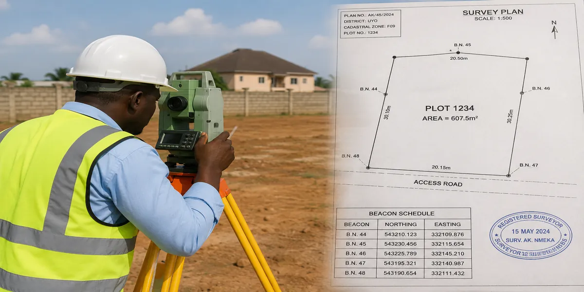
A GPS land surveying operation showing a surveyor capturing coordinates with a GNSS receiver on an open plot.
Don’t Lose Your Money: How to Confirm Land Ownership Before You Pay
The fastest way to verify land ownership in Nigeria is to combine two things: a certified survey plan showing coordinates, beacon numbers, and parcel boundaries, and a GIS check against your state’s land information system to confirm the parcel is registered, free of government acquisition, and matches what the seller has shown you. If both line up, and the survey plan traces back to a genuine title, you are standing on solid ground. If they do not, walk away, no matter how convincing the seller sounds.
I have watched families hand over years of savings for land that turned out to be under government acquisition, or worse, land that had already been sold to three other buyers using photocopied survey plans. In my experience as a town planner working across Akwa Ibom and Rivers States, the buyers who lost money were rarely careless people. They were simply never shown how to read a survey plan or cross-check it with official records. This article fixes that gap. By the time you finish reading, you will know exactly what a survey plan tells you, how GIS mapping confirms or exposes what a seller claims, and the specific steps to take before any money changes hands.
Quick Summary: What This Guide Covers
- What a survey plan actually is, and what it can and cannot prove about ownership
- How GIS and digital mapping now support (and sometimes replace) manual verification
- The exact documents and offices to check before you pay for land
- Common fraud patterns in the Nigerian land market and how to spot them
- Government acquisition, excision, and gazette issues that quietly kill land deals
- A practical checklist you can use on your next site inspection
What a Survey Plan Is, and Why It Matters
A survey plan is a scaled, technical drawing of a piece of land prepared by a licensed surveyor, showing its exact size, shape, boundaries, and position relative to fixed reference points. It is not the same as a title document, and this is where most buyers get confused. A survey plan tells you where the land is and how big it is. A title document (Certificate of Occupancy, Deed of Assignment, Governor’s Consent) tells you who legally owns it. You need both, and they need to match.
Components of a Genuine Survey Plan
- Survey number a unique reference assigned by the state Surveyor-General’s office
- Coordinates precise easting and northing values fixing each beacon on the ground
- Bearings and distances the direction and length of each boundary line
- Beacon information physical concrete markers placed at each corner of the plot
- Parcel identification the layout name, plot number, and district it belongs to
- Surveyor’s seal and signature with a valid registration number from SURCON
During my internship, I observed that many buyers look at a survey plan only to check the size of the land in square metres, and completely ignore the survey number and coordinates. Those two details are exactly what a GIS check needs to confirm the plan is real and registered, not the size.
How GIS Mapping Confirms or Exposes What You Are Told
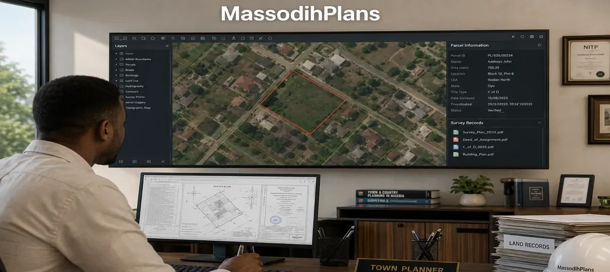
Geographic Information Systems have changed how land verification works in Nigeria over the last decade. Several states, including Lagos, Akwa Ibom, and Rivers, now maintain digital land information systems that overlay registered parcels, acquired areas, gazetted layouts, and existing survey records on a single map. When you submit a survey plan’s coordinates for a GIS search, the system checks it against everything else already registered in that zone.
What a Proper GIS Check Reveals
- Whether the parcel coordinates fall inside a government acquisition or committed acquisition area
- Whether the same coordinates have already been captured under a different owner’s name
- Whether the land falls within a gazetted excision or a free area released for private allocation
- Whether the survey plan number actually exists in the Surveyor-General’s database
- Whether the plot overlaps a road setback, drainage reserve, or other planning restriction
This observation comes from practical field experience: I have seen a client’s coordinates come back as sitting fifteen metres inside a road reserve that never showed up on the survey plan the seller presented. Only the GIS overlay caught it. No amount of staring at a paper survey plan would have revealed that on its own.
Expert Note
• A survey plan without a matching, current GIS or registry confirmation is only half a verification.
• Always ask the surveyor for the parcel’s coordinates in writing, not just the drawing, so you or a second surveyor can independently check them.
Step-by-Step: How to Verify Land Ownership Before You Pay
- Request the original survey plan and a certified true copy of the title document from the seller
- Confirm the surveyor’s registration is active with the Surveyors Council of Nigeria (SURCON)
- Take the survey plan’s coordinates to the state Surveyor-General’s office or GIS unit for a parcel search
- Conduct a search at the state Land Registry to confirm the title is registered in the seller’s name
- Physically inspect the land with a surveyor to confirm beacons on the ground match the drawing
- Check with the town planning authority whether the land falls within any government acquisition, excision, or layout scheme
- Interview at least one neighbouring landowner or family head about the land’s history
- Engage a lawyer to review all documents before payment, not after
Based on projects I have worked on, the single step people skip most often is the physical beacon inspection. A drawing can look perfect, but if the beacons on the ground do not match the coordinates on paper, or worse, if there are no beacons at all, you are looking at a plan that was never properly executed on site.
Nigerian Reality Layer: What Actually Happens on the Ground
In many Nigerian communities, especially in fast-growing areas around Uyo, Port Harcourt, and similar cities, land is still sold based on trust between families rather than formal documentation. A buyer meets a family head, an agreement is reached, money changes hands, and a survey plan is prepared afterward, sometimes years later. This creates a dangerous gap. During that gap, the same piece of land can be shown to other buyers, family members can dispute the sale, or the land can quietly fall under a new government acquisition without the family’s knowledge.
I have encountered this situation multiple times: a client buys land from a family, receives a receipt and a hand-drawn sketch, and only discovers during building plan approval that no genuine survey plan was ever registered for that parcel. At that point, regularising the documents costs far more, in money and time, than doing it correctly from the start would have.
Surveyor’s Practical Layer: Field Observations That Matter
- Beacons sink, get buried under new construction, or get deliberately removed during disputes — always ask when beacons were last confirmed
- Coordinates on old survey plans (pre-2000s in many areas) may use a different datum than current GIS systems, causing apparent mismatches that need a professional to reconcile
- A plot that ‘looks’ rectangular on paper can be a completely different shape on the ground if the original survey was not properly executed
- Access roads shown on a survey plan sometimes do not exist yet, or belong to a different scheme entirely
While working on site plans, I noticed that clients rarely ask when a survey was last verified on the ground. A ten-year-old survey plan for undeveloped bush land is far more likely to have shifted beacons than a plan for a plot inside a controlled, developed layout.
Boundary Disputes, Encroachment, and Missing Beacons
Boundary problems are one of the most common reasons land deals collapse after purchase. A survey plan defines where your land ends and your neighbour’s begins, but only if both parties respect the same reference points.
Common Boundary Problems
- Encroachment a neighbour builds a fence, wall, or structure past the true boundary line
- Missing beacons physical markers are removed, buried, or never installed correctly
- Family land conflicts multiple descendants claim rights over the same undivided parcel
- Overlapping surveys two different survey plans, prepared at different times, claim the same coordinates
One lesson I learned early is that boundary disputes almost never announce themselves before purchase. They surface during construction, when a neighbour suddenly objects to a fence line, or during resale, when a new survey uncovers a discrepancy the original buyer never knew existed. Verifying boundaries before you build, not after, is far cheaper.
Government Acquisition, Excision, and Gazette Issues
This is the category of problem that destroys the most Nigerian land investments, because it is invisible on a simple site visit. Government acquisition means the government has taken legal interest in an area, sometimes for roads, drainage, institutions, or future planning, even if no physical development has started yet.
Key Terms Every Buyer Should Understand
| Term | What It Means for a Buyer |
| Government Acquisition | Government has claimed legal interest in the land; private allocation is restricted or void |
| Committed Acquisition | Land has been earmarked and allocated for a specific government project or agency |
| Global Acquisition | A broad area acquired by government covering multiple communities or layouts |
| Excision | A portion of previously acquired land released back to the community for private use |
| Gazette | The official government publication confirming acquisition, excision, or release status |
| Free Area | Land confirmed as outside any acquisition, available for normal private transactions |
During field inspections, I discovered that many sellers themselves are unaware their land sits inside a global acquisition boundary, because the acquisition may have been declared decades ago and never physically enforced. This does not make the land safe to buy. It means the risk is dormant until the government decides to act, sometimes without compensation if the parcel was never properly excised or regularised.
Warning Signs
- • Seller cannot produce a gazette reference or excision document for land they claim is ‘free’
- • Price is unusually low compared to similar plots in the same area
- • Survey plan has no coordinates, or coordinates the seller refuses to share before payment
- • Multiple ‘agents’ are separately marketing what appears to be the same plot
- • Seller pressures you to pay quickly before you can complete verification
Land Fraud Prevention Layer: Common Scams and How to Avoid Them
Fake Survey Plans
Some survey plans in circulation are outright forgeries, complete with a fabricated surveyor’s seal and a survey number that does not exist in any official register. Others are genuine plans for a different plot entirely, altered and represented as covering the land being sold. Always verify the survey number directly with the Surveyor-General’s office rather than trusting the document on its face.
Multiple Sales of the Same Plot
This is not just theory. I have seen it happen: a single parcel sold to three separate buyers within the same year, each given a survey plan that looked convincing on its own. A registry search and a GIS coordinate check are the only reliable ways to catch this before you become the third buyer with no legal standing.
Forged Coordinates and Altered Documents
- Cross-check coordinates on the survey plan against an independent GIS or registry search, never accept the seller’s copy alone
- Request the surveyor’s original field notes or job number where possible
- Be suspicious of documents that look freshly printed for an supposedly old transaction
- Verify the Governor’s Consent or C of O number directly with the Land Registry
Investment Protection Layer: How Verification Protects Your Money
Land in Akwa Ibom, Rivers State, and most of South-South Nigeria has appreciated steadily over the years, which is exactly why it attracts both genuine investors and fraudulent sellers. Verification is not a bureaucratic delay; it is the single cheapest insurance policy available to a land buyer. A GIS search and registry check typically cost a small fraction of the land’s price, yet they can save the entire investment.
- Verification before purchase costs far less than litigation after a dispute
- A verified parcel with clean documents sells faster and at a better price when you eventually resell
- Lenders and mortgage providers are far more willing to accept verified land as collateral
- Diaspora investors especially benefit from GIS verification, since it can often be initiated remotely through a trusted professional
Construction Reality Layer: How Survey Errors Affect Building Projects
Survey plans do more than confirm ownership; they determine whether your building approval will go smoothly. Architectural drawings and site plans are prepared based on the dimensions and setbacks shown in the survey plan. If the survey plan is inaccurate, or if beacons on the ground do not match the paper drawing, this creates real problems at the building approval stage.
How This Shows Up During Construction
- Setback violations discovered only after foundation work has started, forcing costly redesigns
- Plot utilization disputes when the buildable area is smaller than the survey plan suggested
- Building approval delays when the planning authority’s own GIS records do not match the submitted survey plan
- Boundary conflicts with neighbours that halt construction until resolved
I have seen this mistake repeatedly on sites where the developer never had beacons re-verified before construction. A foundation that follows an outdated or inaccurate survey plan can end up straddling a boundary line, and by the time this is noticed, demolition or costly renegotiation becomes the only option.
Survey Plan Costs and What Affects Them
Survey plan costs vary significantly across Nigeria depending on the state, the size of the plot, terrain, and how far the land is from the surveyor’s base. GIS-based verification searches are typically a separate, smaller cost from the survey itself.
| Cost Factor | How It Affects Price |
| Plot size | Larger parcels require more field time and beacon placement |
| State and locality | Surveyor-General fees and processing charges differ by state |
| Terrain and accessibility | Swampy, forested, or remote land increases field costs |
| Urgency | Rushed jobs often attract premium charges |
| Registration and gazette processing | Formal registration adds separate statutory fees beyond field survey |
One hidden expense buyers often overlook is the cost of correcting an improperly registered survey plan later, which is almost always higher than getting it right the first time. Budgeting for proper verification from the outset is part of responsible land investment, not an optional extra.
Common Mistakes Buyers Make
- Trusting a survey plan without confirming it against the Surveyor-General’s official records
- Paying for land before a physical beacon inspection is carried out
- Ignoring the difference between a survey plan and an actual title document
- Assuming a low price means a good deal, without checking for acquisition or dispute issues
- Skipping a lawyer’s review to save money, then spending far more resolving a dispute later
Practical Verification Checklist
- Original survey plan with visible survey number and coordinates
- Independent confirmation from the Surveyor-General’s office or state GIS unit
- Land Registry search confirming the seller’s title
- Physical beacon inspection with a licensed surveyor present
- Confirmation of acquisition status (free area, excised, or still under acquisition)
- Legal review of all documents by a qualified lawyer
- Written record of the seller’s full identity and any family consent required
Frequently Asked Questions
Can I verify land ownership without visiting the site in person?
A GIS coordinate check and registry search can often be initiated remotely, which is especially useful for diaspora buyers, but a physical beacon inspection should still be carried out by a trusted licensed surveyor on your behalf before you complete payment.
Is a survey plan the same as a title document?
No. A survey plan describes the size, shape, and location of the land. A title document such as a Certificate of Occupancy or Deed of Assignment establishes legal ownership. You need both, and their details must match.
How long does GIS-based land verification take?
This varies by state and the responsiveness of the relevant office, but a straightforward coordinate and registry check typically takes a few days to a few weeks, depending on how busy the Surveyor-General’s office is.
What if the land is under government acquisition but the seller says it has been excised?
Ask for the specific gazette reference confirming the excision, and verify that reference directly with the state government’s land or physical planning office rather than relying on the seller’s word.
Can a survey plan be forged?
Yes, and it happens more often than many buyers realise. Always confirm the survey number and the surveyor’s registration independently, rather than assuming a professional-looking document is genuine.
Final Advice: Protect Your Investment Before You Pay
Verifying land ownership through survey records and GIS mapping is not a formality to rush through after you have already fallen in love with a plot. It is the process that decides whether your investment is secure or exposed. Every step outlined here, the survey number check, the coordinate search, the beacon inspection, the registry confirmation, exists because I have seen what happens when even one of them is skipped.
Before you commit money to any land purchase in Nigeria, insist on a genuine survey plan, get it independently verified through GIS and registry checks, physically inspect the beacons, and have a lawyer review every document. These steps cost far less than the alternative.
If you are planning to build once your land is verified, explore our Plans Library for ready-made Nigerian house designs, or visit Plan School to learn more about the building process from foundation to finish.
For professional support with survey verification, site planning, or architectural design, reach out through our Services page, or return to the MassodihPlans homepage for more trusted, field-tested guidance on building and investing in Nigerian real estate.
Verify before you buy. Protect what you are working so hard to build.
Related post
- How to Invest in Nigerian Real Estate from Abroad: Complete Guide for Diaspora Investors
- Building Regulations Every Nigerian Property Developer Must Know
- GIS Applications in Urban Planning: Real-World Examples That Work
- How to Read a Survey Plan in Nigeria Without Hiring an Expert
- Why Building Plans Get Rejected in Nigeria and How to Get Approval Fast
- National Building Code of Nigeria Explained for Beginners
- Step-by-Step Tutorial for Drawing a Bungalow Plan
- 7 Small Plot Design Mistakes Nigerians Make (And How to Fix Them)
- Best Roofing Sheets for Nigerian Weather: Complete Guide
- Layout Plan Cost in Nigeria and Abroad: What Every Landowner Must Budget Before Building
- Environmental Management Plan Cost Guide for Developers in Nigeria and Beyond
- Cost of Master Plan Preparation for Communities and Institutions
- Architectural Engineering and Architectural Design Courses for House Building Plans
- Luxury 5 Bedroom Duplex Plan With Penthouse in Nigeria
- Housing Estate Layout Plan: Why Every Estate Needs One in Nigeria and Beyond
- Housing Estate Layout Plan: Why Every Estate Needs One in Nigeria and Beyond