How GIS Can Help You Choose the Right Land for Your Dream House in Nigeria
Introduction
Buying land for your dream house in Nigeria can feel simple: find a plot, confirm the documents, pay, and start drawing. But there is a question many buyers ask too late: is this land suitable for the house I want to build? This is where Geographic Information System (GIS) becomes useful.
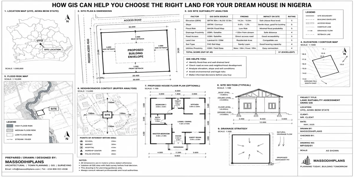
GIS can help you choose better land by turning location information into evidence you can read. Instead of judging a plot only by what you see on site, GIS can help analyse elevation, slope, drainage, flood exposure, road accessibility, land use, proximity to waterways, soil conditions and existing development. These factors can affect construction, comfort and long-term value. Recent Nigerian research is using geospatial and multi-criteria approaches to combine such factors for land suitability and flood assessment.
But here is the part I want you to pay attention to: GIS is not about producing a map. The real value is combining different layers to answer one question: “If I build my home here, what problems could I be buying along with the land?”
In this guide, I will show you how to use GIS thinking before committing your money, including what to check on a plot, how elevation and drainage can expose hidden flood risk, how roads and surrounding development influence accessibility, and how multiple spatial factors can be combined into a land-suitability assessment. You will also learn what GIS cannot confirm by itself and when you still need a surveyor, town planner, architect, geotechnical professional or other qualified expert.
By the end, you should be able to look at land differently not just as property, but as a location with measurable opportunities, constraints and risks.
What GIS Actually Is, Without the Jargon
GIS, Geographic Information System is technology that layers different types of location-based data on top of a map so you can see patterns and risks that aren’t visible from any single source alone. Think of it less as “a map” and more as several transparent sheets stacked on top of each other: one sheet shows elevation, another shows flood-prone zones, another shows soil type, another shows government land acquisitions, another shows existing drainage infrastructure. Individually, each sheet tells you a little. Stacked together over your target plot, they tell you the real story.
For land buyers, this matters because the single most expensive mistakes in Nigerian real estate buying government-acquired land, building on a flood path, sinking a foundation into poor soil, or discovering your “residential” plot is actually zoned for something else are almost all things a proper GIS check catches before you commit money, not after.
Think of GIS as due diligence for the land itself, separate from due diligence on the title documents. Most buyers only do the second one. The plots that cause the most regret are the ones where the paperwork was clean but the land itself had a physical problem no document would ever mention.
Why Land Selection in Nigeria Carries Unusual Risk
Before getting into the GIS layers themselves, it’s worth being specific about what makes land selection in Nigeria riskier than in markets with more mature planning systems, because this is exactly the gap GIS closes.
Land records have historically been poorly digitized, meaning ownership history, government acquisition status, and layout approvals often exist only in fragmented paper archives across different agencies
Rapid, sometimes unregulated development has pushed buildings onto reclaimed wetlands, drainage easements, and erosion-prone slopes that weren’t originally meant for construction
Flooding patterns are worsening and shifting as upstream development changes runoff patterns faster than most buyers’ local knowledge can track
Soil condition varies dramatically over short distances, especially in coastal and riverine states, meaning two plots on the same street can have completely different foundation requirements and costs
Family and communal land disputes remain common, and a plot’s location relative to disputed boundaries isn’t something a single site visit reveals
Encouragingly, this is an area actively improving. Lagos State’s ongoing GIS mapping and house numbering initiatives are expected to strengthen property data reliability, with reforms including GIS mapping and cadastral digitisation forming the backbone of improved access to land data. But “improving” doesn’t mean “solved,” and until it is, the burden of checking properly still sits with the buyer.
The GIS Layers That Actually Matter When Choosing Land
This is the part almost nothing written on this topic actually breaks down specifically. Here is exactly what to look for, layer by layer.
1. Elevation and Topography
Elevation data shows you whether a plot sits in a natural low point relative to its surroundings the single strongest predictor of future flooding risk, more reliable than asking neighbours or checking the plot in dry season. A plot that looks flat and dry in January can be the lowest point on the street once the rains define where water actually collects.
2. Drainage Basin and Runoff Pattern
Beyond elevation alone, drainage mapping shows which direction water moves across an area and where it concentrates. A plot can sit at a reasonable elevation and still be directly in the path of runoff funneling down from a higher street or an inadequate culvert nearby this is precisely what caught the case I opened with.
3. Flood Zone and Hydrological History
Historical flood extent data, where available through state agencies or satellite-derived flood mapping, shows you which areas have flooded in past years not projections, but actual recorded events. This is far more reliable than an agent’s assurance that “this area doesn’t flood.”
4. Soil and Geotechnical Data
Soil composition affects foundation type and cost directly. Sandy, waterlogged, or reclaimed soil common in many coastal and riverine Nigerian locations often requires raft or pile foundations costing significantly more than standard strip foundations on firmer ground. Knowing this before you buy not after your engineer’s soil test surprises you post-purchase changes your budget math on the land itself.
5. Land Use and Zoning Classification
GIS zoning layers show what a plot is actually designated for under the relevant state’s master plan or layout residential, commercial, mixed-use, or reserved for infrastructure which can differ from what an agent tells you or what a neighbouring plot is being used for. Buying residential-zoned land next to a plot informally being used commercially is not the same as buying land the state has actually approved for your intended use.
6. Government Acquisition and Encumbrance Status
This is often the single most financially dangerous thing a buyer can miss. GIS-based land information systems, where accessible through state e-GIS portals, can show whether a parcel falls within a government acquisition, right-of-way, or reserved corridor land that looks completely ordinary and is being actively sold, but which the government can reclaim without full compensation because it was never legitimately released for private ownership.
7. Proximity and Accessibility Analysis
Distance to major roads, schools, hospitals, and markets affects both daily livability and resale value. GIS lets you measure this precisely rather than relying on an agent’s optimistic “just five minutes to the express” a claim that means something very different depending on traffic direction and time of day.
8. Infrastructure and Utility Corridors
Overlaying existing and planned infrastructure power transmission lines, major drainage channels, road reserves, pipeline corridors shows you whether your plot sits close enough to a future expansion or corridor to eventually face compulsory acquisition, or far enough from power infrastructure that connection will be a genuine project of its own.
9. Erosion Susceptibility
Particularly relevant across Akwa Ibom, Rivers, and much of the South-South, where gully and coastal erosion is an active, worsening threat. Slope and soil-type data combined can flag plots at meaningfully higher erosion risk long before visible cracks or gully formation would tip off a physical inspection.
10. Historical Land Cover Change
Comparing satellite imagery of the same plot across several years freely available through tools like Google Earth’s historical imagery shows you whether land currently presented as solid ground was recently a wetland, farmland, or waterbody that’s been filled. Sand-filled wetland is one of the most common disguised risks in fast-growing Nigerian suburbs, and it is almost invisible on a single site visit but immediately obvious across a multi-year image comparison.
No single layer above is sufficient on its own. A plot can pass an elevation check and still fail a drainage-basin check; it can look fine on recent imagery and still show a wetland origin five years back. The value of GIS comes specifically from stacking these layers together, not checking one and stopping.
How to Actually Access and Use GIS in Nigeria Today
This is the practical gap most content leaves unanswered knowing GIS matters is useless without knowing how to actually use it as an individual buyer.
State GIS and e-GIS Portals
Several states now operate digital land information systems that allow verification of title status, acquisition status, and layout approval directly. Lagos State’s GIS and land administration digitization efforts are the most developed nationally, and other states, including Akwa Ibom, have been building out their own geographic information platforms for land administration. Availability and depth of data vary significantly by state, so the first practical step is checking what your specific state’s land bureau or ministry of physical planning offers directly, rather than assuming a Lagos-level system exists everywhere.
Licensed Surveyors and GIS Professionals
Where a state’s public portal has limited data, a licensed surveyor or GIS-competent town planner can pull and interpret the layers above using professional GIS software and available government datasets this is a service worth paying for on any serious land purchase, because interpreting overlapping layers correctly takes technical judgment, not just access to a map.
Free and Accessible Tools for a First-Pass Check
Before engaging a professional, a buyer can do a genuinely useful first-pass check using freely available tools:
- Google Earth’s historical imagery slider, to check a plot’s land cover over the past 5–10 years
- Google Maps’ terrain and satellite views, to get a rough sense of elevation relative to surroundings
- State ministry of physical planning websites, many of which now publish layout plans or zoning information online
None of these substitute for a proper survey and professional GIS review, but they can flag obvious problems recent land-filling, an unusually low-lying plot before you spend money on formal due diligence.
Do the free first-pass check yourself before you even shortlist a plot seriously. It costs nothing but time, and it will quickly eliminate the plots not worth paying a professional to investigate further.
A Practical GIS-Informed Land Selection Process
Shortlist based on standard criteria budget, location preference, size the way most buyers already do
Run the free first-pass check on each shortlisted plot: historical imagery, terrain view, basic zoning information where published
Eliminate obvious red flags visibly recent land-filling, plots sitting in a clear low point relative to their street
Engage a licensed surveyor or GIS-competent professional for your top two or three remaining candidates, requesting specific checks: government acquisition status, drainage basin position, soil type, and zoning classification
Cross-check the professional’s GIS findings against the physical site visit walk the plot at the lowest point of its boundary, ask neighbours directly about flooding history, and look for water marks or erosion signs the imagery might not show
Only then proceed to legal title verification GIS and physical/geotechnical due diligence should happen before, or at minimum alongside, legal searches, not after you’re already committed
What GIS Cannot Tell You
Being direct about the limits matters as much as explaining the capability. GIS will not verify that the person selling you the land actually owns it that’s a legal title search, done through the relevant land registry, and it remains essential regardless of how clean the GIS data looks. GIS also can’t fully replace a physical soil test geotechnical data layers give you a strong indication, but a proper soil investigation on your specific plot before foundation design is still necessary. And GIS data quality varies by state and by dataset age, so a clean-looking result in an area with poor data coverage is not the same as a genuinely verified clean result treat data gaps as a reason for more caution, not less.
Common Land-Buying Mistakes GIS Prevents
Buying recently filled wetland or waterbody presented as solid, developable land
Buying into a government acquisition or right-of-way that can be reclaimed without full compensation
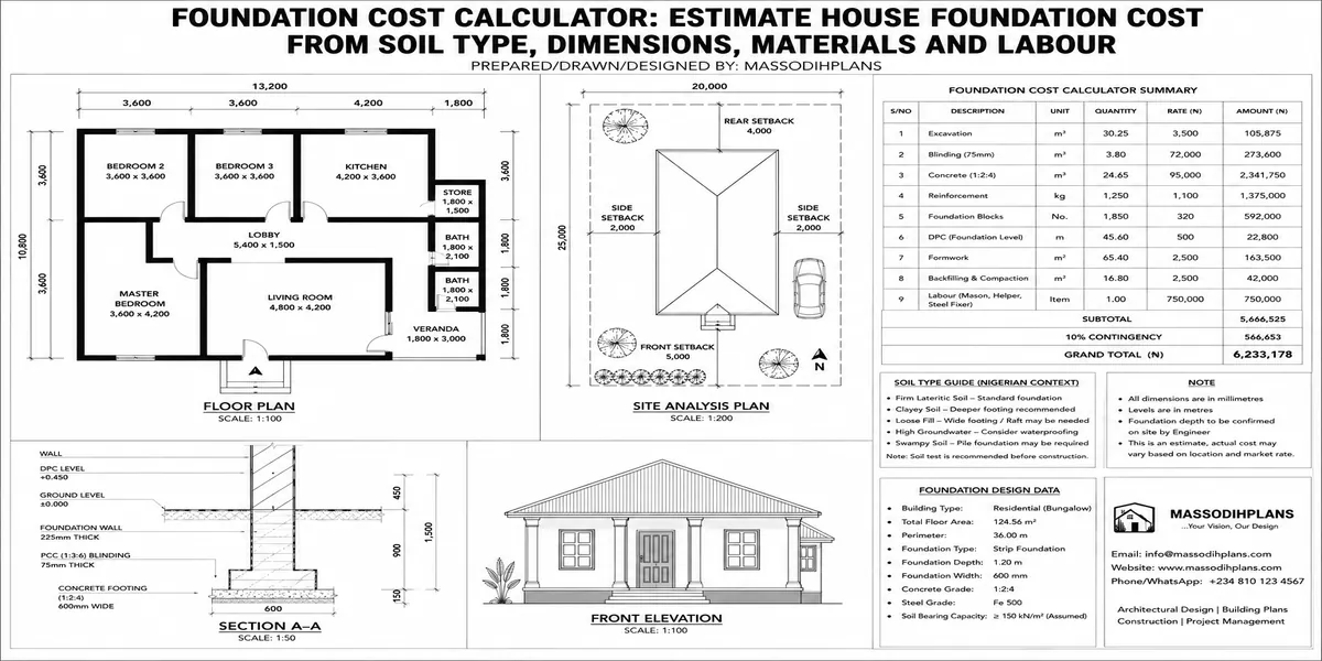
Underestimating foundation cost by not knowing the plot’s actual soil type before budgeting
Buying land in an active or worsening erosion zone, particularly relevant across much of the South-South
Trusting an agent’s flood claims without checking actual elevation and drainage basin position
Missing zoning mismatches between what a plot is approved for and what it’s being marketed as
Frequently Asked Questions
Do I need to be a GIS expert to use this before buying land?
No. A basic first-pass check using free tools like Google Earth’s historical imagery is accessible to anyone, and for the deeper layers acquisition status, soil, zoning you engage a licensed surveyor or GIS-competent professional the same way you’d engage a lawyer for title verification.
Is GIS data available for all of Nigeria, or just Lagos?
Coverage and depth vary significantly by state. Lagos currently has the most developed public land information and mapping infrastructure, but other states, including Akwa Ibom, are actively building out their own systems, so availability should be checked directly with each state’s ministry of physical planning or land bureau.
Can GIS tell me if land is government-acquired?
Where a state’s land information system includes acquisition and encumbrance layers, yes this is one of the most valuable checks GIS offers. Where such a system isn’t fully developed for a given state, this check may still require a manual search at the relevant land bureau in addition to any available GIS data.
How is GIS different from a regular land survey?
A land survey establishes and legally documents your plot’s precise boundaries. GIS layers show you contextual risk and status information flooding, soil, zoning, acquisition about the land within and around those boundaries. You need both; they answer different questions.
Does GIS replace the need for a lawyer when buying land?
No. GIS and geotechnical due diligence assess the physical and administrative risk of the land itself. A lawyer verifies legal ownership and handles title transfer. Skipping either one leaves a real gap in your due diligence.
Final Thoughts
The plots that cause the most regret in Nigeria are rarely the ones with obviously bad paperwork those get caught by a basic legal search. They’re the ones that look perfect on a dry-season visit and turn out to sit in a drainage path, on filled wetland, or inside a government corridor nobody mentioned. That is precisely the gap GIS closes, and it is available to you as a buyer well before you’re standing in front of a surveyor’s bill or, worse, a flooded foundation.
If you’re evaluating land for a home you’re planning to build, our Services page outlines how we support clients through site and land due diligence alongside design. Browse our Plans Library once your land is confirmed suitable for the kind of home you have in mind, or visit Plan School to understand how site conditions actually shape a workable building plan. You can also explore more land and planning guides on our Homepage.
Related Guides
- Semi-Detached House Plans: Modern Duplex and Bungalow Designs With Shared Walls, Dimensions, Costs and Layout Ideas
- Courtyard House Plans: Beautiful 2–6 Bedroom Designs With Private Outdoor Spaces, Floor Plans and Dimensions
- Contemporary House Plans: Modern 2–6 Bedroom Designs With Open Layouts, Large Windows, Dimensions and Costs
- House Finishing Cost in Nigeria: Complete Breakdown of Tiles, Painting, Ceiling, Doors, Plumbing and Electrical Work
- Foundation Cost Calculator: Estimate House Foundation Cost From Soil Type, Dimensions, Materials and Labour
- Block Quantity Calculator: How to Calculate the Number of Blocks Needed for Any House From Your Floor Plan
- Cement Quantity Calculator for Building: Calculate Bags Needed for Foundation, Blockwork, Slab, Plastering and Screeding
- Self-Contained House Plans: 15 Efficient Designs With Room Dimensions, Floor Plans, Building Costs and Ideas
- 1 Bedroom House Plan: Affordable Self-Contained Floor Plans With Dimensions, Materials, Cost and Space-Saving Ideas
- 6 Bedroom House Plans: Modern Nigerian Floor Plans With Dimensions, Ensuite Rooms, Parking and Cost Estimates
Author
Massodih Okon is a Nigerian built-environment professional with academic and professional experience in urban and regional planning, geography, architectural design, Landscape Design, GIS and land development.
He holds a Master’s degree in Urban and Regional Planning from the University of Uyo and a first degree in Geography and Regional Planning.
Through MassodihPlans, he publishes practical guides on Nigerian house plans, building design, physical planning, site planning, development approval and residential construction. Read the full author profile →