Land Use: How Is Land Used? Planning, Mapping, Zoning and Development
A client once sent me a survey plan for a plot he had already paid for in full. Beautiful location, good access road, price that felt like a steal. The problem showed up the moment I checked it against the local land use plan: the plot sat inside a designated green/recreational zone, not residential land. He couldn’t legally get building approval for the house he’d already started designing in his head. Nobody had lied to him outright he simply never asked the one question that would have caught it, because nobody had ever explained to him what “land use” actually means in a way he could act on.
That gap between hearing the term “land use” everywhere and actually knowing how to use that knowledge to protect your money is what this piece is for. I’m going to walk through it the way I’d walk a client, a student, or a fellow planner through it: what land use actually is, how it’s classified and mapped, how zoning turns a plan into enforceable law, how suitability analysis decides what should go where, and because almost nobody explains this part how you personally check whether the zoning or GIS data you’re relying on is even accurate before you commit money to it. See FAO integrated land-use planning.
Land Use: What It Actually Means
Land use is simply how a piece of land is being employed by people for housing, farming, commerce, industry, recreation, conservation, or infrastructure. It sounds obvious until you realize it’s actually answering two different questions that people constantly mix up:
What is the land currently being used for? (the observed, on-the-ground reality a farm, a market, an empty plot)
What is the land legally permitted to be used for? (the zoning or land use designation on record with the planning authority)
These two answers frequently disagree, and almost every real land use dispute I’ve handled traces back to someone assuming they were the same thing. A plot can be physically vacant bush today and still be legally zoned for high-density residential, industrial, or conservation use and that legal designation, not what you can see standing on the land, is what determines what you’re allowed to build.
Never judge what a plot can be used for by what’s currently sitting on it. A “vacant” plot could be zoned for anything. A “farm” could be zoned for future residential expansion. Always ask for the land use designation, not just a physical description of the site.
Land Use Planning: The Process Behind the Map
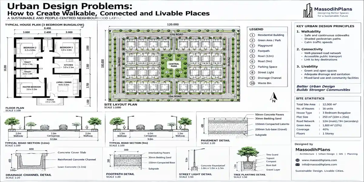
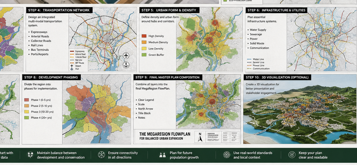
Land use planning is the structured process governments and planning authorities use to decide how land within their jurisdiction should be organized where housing goes, where industry goes, where roads, schools, drainage, and green space need to be reserved, and how all of it should grow over time.
It typically works through a hierarchy:
Regional/state plans set broad direction growth corridors, conservation areas, major infrastructure corridors
Master plans translate that direction into a specific area’s layout road networks, land use zones, density targets
Layout/site plans get granular individual plots, streets, and utility routing within an approved master plan
Development control is the day-to-day enforcement layer reviewing individual building applications against all of the above
Good land use planning isn’t just drawing colored zones on a map. It’s balancing competing demands housing pressure against agricultural land, industrial growth against residential quality of life, commercial development against traffic capacity while reserving space for the infrastructure (roads, drainage, schools, health facilities) that all of it depends on. This is why a plan that looks purely aesthetic on paper can fail badly in practice if it didn’t account for how people, goods, water, and traffic actually move.
Land use planning documents are usually public records. Before buying land or committing to a design, request the approved land use or master plan for that area from the relevant planning authority don’t rely on what an agent or seller tells you the zoning is.
Land Use Map: Reading the Document That Actually Governs Your Plot
A land use map is the visual record showing how land within an area is designated colour-coded zones for residential, commercial, industrial, agricultural, institutional, and conservation use, layered over the area’s roads and boundaries.
Reading one properly means knowing what to check beyond just “what colour is my plot”:
The legend/key — colour codes vary between authorities, so never assume a colour means the same thing on two different maps
The date and approval status — an outdated or draft land use map can differ significantly from the current legally binding version
Boundary precision — zone boundaries drawn at map scale can shift by tens of metres in reality; a plot sitting near a zone boundary line needs ground verification, not just a visual read of the map
Overlays — many land use maps carry additional layers (flood zones, easements, right-of-way corridors) that override or modify the base zoning designation for specific plots
A land use map answers “what is this area meant to become,” while your specific plot’s approval history answers “what is legally recorded for this exact piece of land right now.” Both matter, and they don’t always agree especially in areas where the master plan was approved years ago but development on the ground has moved faster or differently than planned.
Land Use Classification: The Categories Behind the Colours
Land use classification is the system of categories used to label how land is designated or used. While systems vary by country and authority, most classifications share a common backbone:
- Residential — housing at varying densities (low, medium, high)
- Commercial — retail, offices, markets, hospitality
- Industrial — manufacturing, warehousing, heavy and light industry
- Institutional — schools, hospitals, government facilities, religious buildings
- Agricultural — farmland, plantations, livestock use
- Recreational/Open Space — parks, green belts, sports facilities
- Mixed-Use — combined residential/commercial designations within one zone
- Conservation/Protected — wetlands, forest reserves, ecologically sensitive land
- Infrastructure/Utility — roads, drainage corridors, power installations, waste facilities
Classification systems also often carry a density or intensity sub-label for instance, residential land might be further split into low-density, medium-density, and high-density categories, each carrying different plot coverage, height, and setback rules. This sub-classification is frequently where people get caught out: a plot correctly identified as “residential” can still be the wrong classification for the specific building density someone intends.
Land Use Change and Land Use Change Detection
Land use change is exactly what it sounds like land shifting from one use to another over time: farmland becoming residential estates, industrial land being redeveloped into mixed-use, or green space being lost to informal development. It’s driven by population growth, economic pressure, policy shifts, and infrastructure expansion, and it’s one of the fastest-moving realities in rapidly urbanizing regions.
Land use change detection is the technical process of identifying and measuring that change, usually by comparing satellite imagery or aerial data from different time periods to see what has physically changed on the ground. This matters far beyond academic research:
- Planning authorities use it to check whether development is following the approved plan or diverging from it
- It reveals informal or unapproved development that hasn’t been captured in official records
- It tracks environmental impact loss of green cover, wetland encroachment, agricultural land conversion
- It’s increasingly used to update outdated land use maps that no longer reflect what’s actually happening on the ground
For anyone buying land in a fast-growing area, this is genuinely useful to know: if the official land use map for your area is more than a few years old, there is a real chance the actual land use pattern on the ground has already outpaced it, in either direction either informal development the map doesn’t show, or planned infrastructure that hasn’t been built yet.
Land Use Planning and Management: Beyond the One-Time Plan
Land use planning and management is the ongoing discipline of not just creating a plan, but maintaining, monitoring, and adjusting it over time. A plan approved once and never revisited becomes increasingly disconnected from reality as an area develops which is exactly the failure pattern behind many of the flooding, congestion, and informal-settlement problems visible in fast-growing cities.
Effective management includes:
Monitoring compliance — checking that actual development matches approved land use designations
Enforcement — acting on violations (unauthorized change of use, encroachment on reserved land) before they become entrenched and politically difficult to reverse
Periodic review and updating — revising the plan as population, economic activity, and infrastructure capacity change
Stakeholder engagement — incorporating community input, since land use decisions directly affect the people living within them
Infrastructure coordination — ensuring road, drainage, water, and power planning keeps pace with the density the land use plan permits
The uncomfortable truth in much of rapidly urbanizing West Africa is that land use planning is often reasonably strong on paper, while land use management the ongoing enforcement and updating is where things break down, letting informal development outpace formal planning until services genuinely can’t cope.
Land Suitability, Suitability Analysis, and Suitability Mapping
This is the part of land use work that decides not just what land is currently designated for, but what it should actually be used for, based on its physical and environmental characteristics.
Land suitability is the degree to which a particular piece of land is fit for a specific use, based on factors like soil type, slope, drainage, flood risk, and proximity to infrastructure.
And Land suitability analysis is the structured process of evaluating those factors usually weighting and combining multiple criteria (soil quality, slope, water table depth, distance to roads, flood history) to score how appropriate a piece of land is for a proposed use.
Land suitability mapping is the visual output of that analysis a map showing suitability scores or categories (highly suitable, moderately suitable, unsuitable) across an area for a specific use, such as residential development or agriculture.
This matters directly to anyone buying land, because a plot can be zoned residential and still be poorly suited for it sitting on a high water table, within a flood-prone depression, or on unstable reclaimed soil long before zoning classification ever enters the conversation. Zoning tells you what’s legally permitted. Suitability tells you what’s physically sensible. You need both answers, and they are not the same question.
Before buying, ask specifically about the plot’s drainage history and soil condition, not just its zoning status. A plot can pass every zoning check and still cost you significantly more at foundation stage because nobody checked suitability first.
Land Use Planning Map: Where Plan Meets Territory
A land use planning map is the specific document produced during the planning process that shows proposed or approved land use designations across an area essentially the master plan’s land use layer, made explicit and legally referenceable. It’s distinct from a general “land use map” in that it usually represents the forward-looking, officially adopted plan for an area, rather than a snapshot of current conditions.
When you request planning information from an authority, this is usually the specific document you want, because it tells you what an area is meant to become informing whether the neighbourhood you’re buying into is planned to stay low-density residential, or is already designated to absorb future commercial or higher-density growth that will change its character.
Zoning, Zoning Regulations, and Zoning Laws
Yes, Zoning is the legal mechanism that translates a land use plan into enforceable rules for specific parcels dividing land into designated zones (residential, commercial, industrial, and so on) and attaching specific permitted uses and development standards to each one.
Zoning regulations are the detailed rules attached to each zone permitted uses, minimum plot sizes, setbacks, height limits, plot coverage ratios, parking requirements, and density caps. These are the numbers that actually constrain what you can legally build.
Zoning laws are the legal instruments statutes, ordinances, or state-level planning laws that give zoning regulations their legal force and establish the authority and process for enforcing them, granting variances, and handling violations.
The distinction matters practically: regulations tell you the specific numbers (a 3-metre setback, a 40% plot coverage cap); laws tell you the legal authority and process behind those numbers, including how to challenge or apply for an exception. Most people only ever encounter the regulations, but the underlying law is what determines whether a variance is even possible and what the penalty structure looks like for non-compliance.
Zoning Map and Property Zoning
A zoning map is the specific map showing zoning designations for every parcel within a jurisdiction the legally operative document that determines what an individual plot can be used for and built on.
Property zoning simply refers to the zoning classification of one specific property the answer to “what can I actually do with this plot” once you’ve located it on the zoning map and read its designation and attached regulations.
Here’s the practical sequence most people get backwards: they fall in love with land first, and check its zoning last sometimes after money has already changed hands. The correct order is to identify the zoning designation and its regulations before valuing the land at all, because the same plot in the same location can be worth dramatically different amounts depending on what it’s legally permitted to become.
Residential, Commercial, Industrial, and Mixed-Use Zoning
Each zoning category carries a different bundle of permitted uses and regulatory standards, and understanding the differences prevents a lot of expensive assumptions.
Residential Zoning
Governs land designated for housing, typically sub-classified by density (low, medium, high) and sometimes by housing type (single-family, multi-family, estate). Regulations usually cover minimum plot size, setbacks, height limits, and permitted ancillary uses (home offices, small-scale commercial activity, in some jurisdictions).
Commercial Zoning
Governs land for retail, offices, hospitality, and similar business uses. Regulations here often focus on parking provision, signage, building coverage, and sometimes hours of operation or noise limits, reflecting the different neighbourhood impact commercial activity has compared to housing.
Industrial Zoning
Governs manufacturing, warehousing, and heavy or light industrial use, typically with the most permissive height and coverage allowances but the strictest requirements around buffer distances from residential zones, environmental controls, and heavy vehicle access.
Mixed-Use Zoning
Deliberately allows a combination of residential, commercial, and sometimes light institutional use within the same zone or even the same building ground-floor retail beneath residential units, for example. Mixed-use zoning has become increasingly favoured in modern planning because it supports walkable, self-sufficient neighbourhoods rather than forcing every trip into a car, but it requires careful regulation of noise, access, and parking to work well in practice.
If you intend any commercial activity on residentially zoned land a shop, a small office, a short-let arrangement check whether that specific use is actually permitted under the zone’s regulations. “Residential” zoning does not automatically permit every non-industrial activity; some commercial uses require a variance or fall outside what’s allowed entirely.
How to Check Whether GIS Data Is Accurate and Current (A Practical Checklist)
This is the part almost nobody explains in plain language, and it’s become essential because so much land use, zoning, and suitability information now comes packaged as GIS layers, satellite-derived maps, or online zoning portals that look authoritative but may not actually be current or correctly referenced.
1. Check the Metadata Before You Trust the Map
Every credible GIS dataset should carry metadata stating its source, capture or survey date, coordinate reference system, and the authority responsible for it. If a map or GIS layer has no visible metadata, treat it as unverified until you can trace where it actually came from.
2. Confirm the Coordinate Reference System (CRS) Matches
Data captured in one coordinate system and displayed without correct reprojection can shift features by metres, sometimes enough to move a boundary from one plot to another. If you’re combining data from multiple sources (a survey plan, a zoning layer, a satellite basemap), confirm they’re all referenced to the same CRS before drawing conclusions from how they overlay.
3. Cross-Check Against Ground Truth
GIS layers should be verified against at least one independent, on-the-ground source a physical survey, visible boundary markers, or a site visit rather than accepted purely on the strength of how convincing the digital map looks. A well-rendered map can still be wrong; polish is not the same as accuracy.
4. Check the Currency of Satellite or Aerial Imagery
Most mapping platforms display an imagery capture date somewhere in their interface. In fast-changing urban areas, imagery even two or three years old can miss significant new development, informal settlement, or infrastructure changes always check this date before relying on what you see as current reality.
5. Compare Multiple Independent Sources
Where possible, compare the GIS data or zoning information from the official planning authority against at least one other independent source a licensed surveyor’s data, a different government portal, or commercially available satellite basemap data. Agreement across independent sources is a much stronger accuracy signal than any single source alone, however official it looks.
6. Verify the Data’s Resolution Matches Your Need
A national-scale land use dataset with low positional accuracy is not reliable for deciding an individual plot boundary, even though it’s perfectly adequate for regional planning analysis. Match the resolution and intended scale of the data to the actual decision you’re making with it.
7. Check for a Version or Revision History
Authoritative planning and GIS data should show when it was last updated and ideally what changed. Data with no revision trail at all is harder to trust, because you have no way to know whether it reflects a plan from ten years ago or one adopted last month.
If a zoning portal, app, or GIS layer won’t tell you its source, its capture date, or its coordinate reference system, don’t build a financial decision on it alone. Treat it as a starting point for questions to the planning authority, not a final answer.
Land Use, Zoning, and Property Value: The Connection Nobody Draws Clearly
Here is something that rarely gets stated directly: zoning and land use designation are often a bigger driver of a plot’s value than its physical location or size. Two plots of identical size, in the same general area, can carry very different values purely because one is zoned for higher-density residential or mixed-use development and the other is restricted to low-density single-family use. Before you value land, know its zoning the zoning designation effectively sets the ceiling on what that land can ever become, regardless of how good the location feels.
This works in the other direction too: a rezoning decision land use change approved through the formal planning process can significantly increase or decrease surrounding property values, which is exactly why zoning changes are usually subject to public notice and objection periods in most jurisdictions. If you own land near an area under active land use review, that review is worth tracking, because its outcome affects your property’s value whether or not you participate in the process.
Land Use Conflicts and How They’re Actually Resolved
Land use conflict happens when incompatible uses end up adjacent to each other, or when a use violates its designated zoning an industrial operation encroaching near housing, a commercial activity operating in a residential zone, or a boundary dispute rooted in unclear or outdated mapping.
Most formal resolution paths follow a similar pattern:
Verification — confirming the actual zoning designation and boundary through official records, not assumption
Mediation or formal complaint — raised through the local planning authority, often the fastest route for a clear violation
Variance or rezoning application — where a use doesn’t fit current zoning but there’s a reasonable case for an exception
Enforcement action — where a planning authority orders a non-compliant use to cease or a structure to be modified or removed
Legal action — the last resort, usually reserved for disputes the administrative process can’t resolve, particularly boundary disputes tied to conflicting survey data
Most land use conflicts I’ve seen personally trace back to one of two root causes: someone building without checking current zoning at all, or someone relying on outdated map data that didn’t reflect a zoning change already in effect. Both are entirely preventable with the verification habits covered throughout this guide.
Frequently Asked Questions
What is the difference between land use and zoning?
Land use describes how land is or should be used in general terms (residential, commercial, agricultural). Zoning is the specific legal mechanism that assigns enforceable designations and regulations to individual parcels, giving land use planning legal force at the plot level.
How do I find out the zoning of a specific piece of land?
Request the current zoning map or land use planning map from the relevant local planning authority, and confirm the specific parcel’s designation and attached regulations directly with them rather than relying solely on a seller, agent, or third-party app.
Can zoning be changed?
Yes, through a formal rezoning or land use change application to the relevant planning authority, usually involving public notice and, in many jurisdictions, an opportunity for surrounding property owners to object or comment before a decision is made.
What is the difference between a land use map and a zoning map?
A land use map often shows broader designated or observed land use categories across an area, sometimes including proposed future use. A zoning map is the specific, legally operative document showing the enforceable zoning classification for every individual parcel.
Why does land suitability matter if a plot is already correctly zoned?
Zoning tells you what’s legally permitted; suitability tells you whether the land’s physical characteristics soil, drainage, slope, flood risk actually support that use safely and cost-effectively. A plot can pass zoning entirely and still be a poor physical choice for the intended development.
How current does land use or GIS data need to be before I can trust it?
There’s no single universal cutoff, but always check the data’s capture or last-revision date against how fast the specific area is developing a dataset that’s perfectly reliable for a slow-changing rural area can already be outdated for a fast-growing urban fringe.
Finally
Land use, planning, mapping, zoning, and suitability aren’t separate topics they’re different layers of the same question: what is this land allowed to become, what is it actually fit for, and how current is the information you’re using to answer both? The client I mentioned at the start eventually got his money back, but only after months of avoidable stress that a single zoning check, before payment, would have prevented entirely. That’s the real, practical reason this guide exists not to make you a planner, but to make sure you never find out the hard way what your land’s designation actually is.
If you’re planning to buy land or commission a design and want that verification done properly before you commit, our Services page outlines how we support clients through zoning and site verification alongside design work. Browse our Plans Library for house plans already matched to common Nigerian zoning and plot realities, or visit Plan School to build your own understanding of the planning and approval process step by step. You can also explore more planning and land guides on our Homepage. My people read about these also:
- Drainage, Flood & Environment: How to Manage Stormwater and Reduce Flood Risk
- How Much Does Home Renovation Cost? A Practical Guide to Remodeling and Home Improvements
- Interior Home Design: How to Plan Beautiful Rooms, Layouts and Decor
- Roofing Problems Solved: Roof Design, Costs, Materials and Installation Now
- Foundation Problems, Types, Cost and Design for Safe House Construction
- GIS Property Planning: How GIS Mapping Solves Land and Site Problems
Author
Massodih Okon is a Nigerian built-environment professional with academic and professional experience in urban and regional planning, geography, architectural design, Landscape Design, GIS and land development.
He holds a Master’s degree in Urban and Regional Planning from the University of Uyo and a first degree in Geography and Regional Planning.
Through MassodihPlans, he publishes practical guides on Nigerian house plans, building design, physical planning, site planning, development approval and residential construction. Read the full author profile →