GIS Property Planning How GIS Mapping Solves Land and Site Problems
A client once brought me a survey plan for a plot he was two weeks from paying for in full. On paper, everything looked fine coordinates, dimensions, a surveyor’s stamp. When I laid it against the state’s digital layout and satellite imagery, half of that plot sat inside a drainage right-of-way the government had already marked for a road expansion. No contractor would ever have caught that by walking the land. A GIS overlay caught it in twenty minutes.
That is the actual value of GIS in property work, and it has almost nothing to do with the buzzwords most articles about it are built around. This piece isn’t a definitions lecture. It’s a walkthrough of the specific land and site problems GIS solves, written by someone who uses it to protect real clients’ money, not to sell software.
What GIS Actually Is, Without the Jargon
GIS stands for Geographic Information System. Strip away the acronym and it’s simply this: a way of storing information about a place boundaries, elevation, soil type, flood zones, roads, ownership as layers tied to exact coordinates, so you can view them together and see relationships a flat document could never show you.
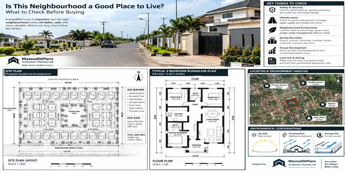
A survey plan tells you the shape of your plot. A geographic information system can tell you that shape, layered against the government’s road-widening plan, the nearest flood-prone contour, the drainage easement running behind it, and three other plots that also claim part of that same boundary. That layering not the software itself is what makes GIS useful for anyone dealing with land.
GIS Mapping vs. Property Mapping vs. Cadastral Mapping vs. Parcel Mapping: Why People Confuse These
This is the single biggest source of confusion I encounter, and almost nothing online untangles it plainly, so let’s fix that first.
GIS mapping
Is the broad practice using GIS software to create any kind of map from spatial data. It’s the toolset, not a specific output.
Property mapping
Is GIS mapping applied specifically to identifying and visualizing individual properties where a plot sits, its shape, and its relationship to surrounding features.
Cadastral mapping
Is a more formal, legally-grounded version of property mapping. A cadastral map shows land parcels with their official boundaries and ownership information, and is treated as a legally recognized document used for taxation, ownership records, and land transfer it’s authoritative in a way an informal property map isn’t.
Parcel mapping produces a parcel map
Visually similar to a cadastral map, but the term “parcel” is more commonly used in property tax administration and land records systems, especially the way local government and county-style systems organize individual land units for assessment purposes.
Cadastral survey
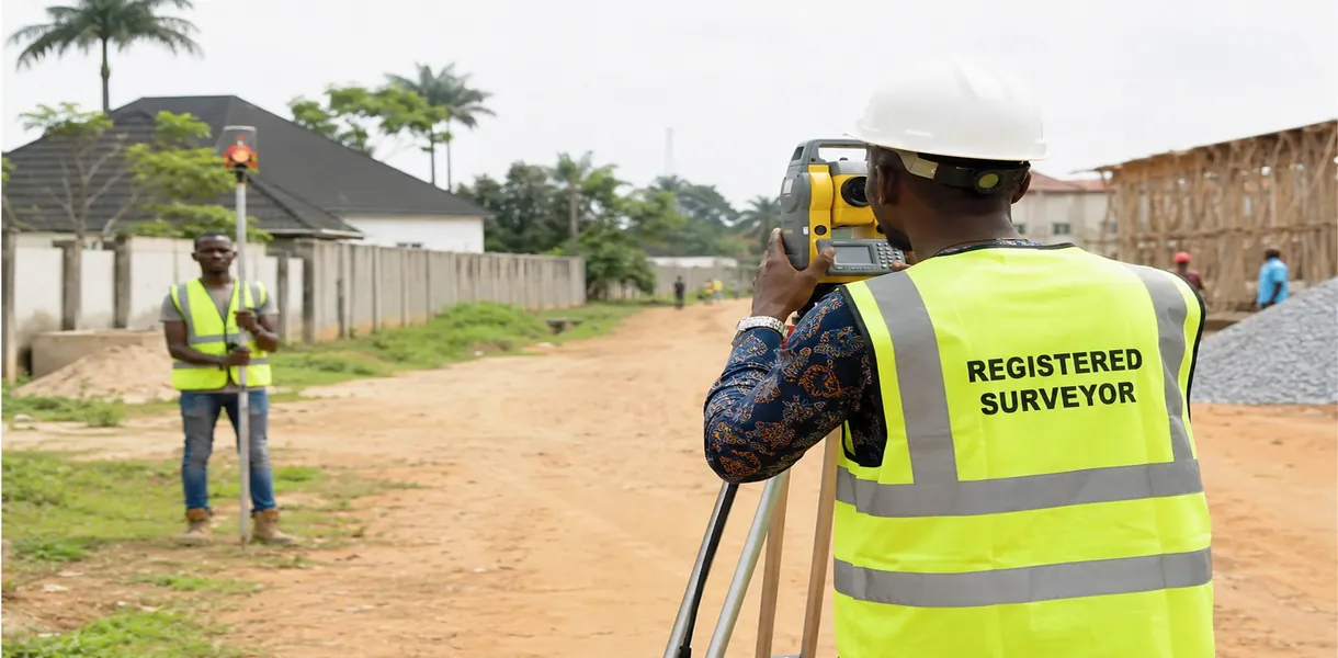
Is the actual ground-based (or GPS/GNSS-based) surveying work that establishes those legal boundaries in the first place the fieldwork that produces the coordinates a cadastral map later displays. Cadastral surveying is the sub-field of surveying that specializes in establishing and re-establishing real property boundaries, applying both spatial-measurement principles and legal principles such as respecting neighbouring titles.
In practice, for a Nigerian property buyer or developer: your survey plan is the cadastral survey’s output, a cadastral map is what that data looks like laid over other plots in an area, and GIS property mapping is the process of digitizing all of that so it can be checked, overlaid, and queried instead of just filed away as a paper document.
When someone offers you a “GIS map” of a property, ask specifically whether it’s tied to survey coordinates from a registered surveyor, or whether it’s just a visual sketch pulled from satellite imagery. Only the first one has any legal weight if a dispute ever arises.
The Land Problems GIS Actually Solves
Rather than list features, here are the specific, recurring problems GIS mapping solves the ones that cost people real money when they go unnoticed.
Overlapping and Fraudulent Land Claims
This is the single most common land problem in fast-growing Nigerian cities. A GIS overlay lets you place your survey coordinates directly against the government’s existing layout plan and any other registered parcels in the area instantly revealing whether the same land has been sold to more than one party, or whether a “vacant” plot you’re being shown is actually already registered to someone else. This is the exact scenario that ended my client’s near-purchase above.
Land Sitting on Government-Acquired or Committed Land
Government acquisition land marked for future roads, drainage, power lines, or public infrastructure is rarely obvious from standing on the plot. GIS layers combining the state’s infrastructure and layout plans with your specific coordinates reveal this immediately, before you commit money to land you’ll eventually be asked to vacate.
Boundary and Encroachment Disputes
When two neighbours each insist their fence is on the correct line, GIS resolves it the only way that actually settles the argument: by placing both parties’ surveyed coordinates against the same reference system and showing exactly where the real boundary falls, rather than relying on memory, old fences, or verbal agreements between long-departed original owners.
Building on Unsuitable Land Without Realizing It
This is what GIS land suitability analysis exists for combining soil data, elevation, flood-risk zones, and drainage patterns to determine whether a specific plot is actually appropriate for the kind of building you intend, before you spend money on foundation work that a suitability check would have flagged as high-risk.
Choosing the Wrong Site for a Business or Project
GIS site selection solves the problem of picking a location based on gut feeling or price alone. By layering population density, road access, competitor locations, and infrastructure data, GIS site analysis gives an evidence-based answer to “where should this actually go” turning a guess into a decision you can defend.
Losing Track of What You Own Across Multiple Properties
For anyone holding more than a handful of properties, GIS property management solves the problem of scattered paper records consolidating every plot’s boundaries, tenancy status, tax records, and maintenance history into one queryable system instead of a filing cabinet or a memory nobody fully trusts.
Not Knowing What a Piece of Land Is Actually Zoned or Used For
GIS land use mapping solves the problem of committing to a project only to discover the land is zoned for something incompatible residential land you assumed was commercial, agricultural land inside a residential layout, or a plot inside a green-belt or conservation designation that restricts what can legally be built.
Real Estate Decisions Made on Incomplete Information
GIS real estate applications solve the buyer’s-information problem overlaying comparable sales, flood history, access road quality, and proximity to infrastructure so a purchase decision isn’t based purely on what an agent tells you standing at the gate.
Cities Growing Faster Than Planning Can Track
GIS urban planning, or GIS for urban planning, solves the problem every fast-growing Nigerian city faces: development outpacing the planning authority’s ability to track it. It lets planners see, in one layered view, where infrastructure capacity, zoning, and actual development are falling out of alignment the gap that produces the flooding and gridlock so many neighbourhoods eventually suffer.
How GIS Site Analysis Actually Works, Step by Step
Since GIS site analysis gets mentioned constantly but rarely explained, here’s what the process genuinely involves:
Define the criteria that matter for the specific use for a residential plot, that’s drainage, soil bearing capacity, and access; for a commercial site, it’s traffic flow, visibility, and population density
Gather the relevant data layers topography, soil, flood zones, existing infrastructure, zoning, and any available satellite or drone imagery
Overlay the layers against the specific site’s coordinates this is the step that actually produces insight; individual layers alone tell you far less than seeing them together
Weight the criteria by importance for the specific project, since not every factor matters equally for every use case
Generate a suitability output a map or score showing which parts of the site (or which of several candidate sites) actually meet the requirements
Ground-truth the result GIS output should always be checked against a physical site visit and, where land ownership is involved, an actual cadastral survey; software output is a strong lead, never a final legal answer on its own
GIS Mapping Services: What to Actually Look For
Not all GIS mapping services are equal, and most buyers have no way to judge quality until it’s too late. Here’s what separates a genuinely useful service from one that just produces a nice-looking image:
Ask what data sources feed the map. Government survey records and registered cadastral data carry legal and practical weight; satellite imagery alone, without ground-truthing, does not.
Ask how current the data is. This matters enough that it deserves its own section below.
Ask whether the output is tied to coordinate systems compatible with your state’s survey office, not just a visually convincing map with no legal traceability.
Ask whether a physical or drone-based verification was done, or whether the entire output is desk-based.
Check whether the provider can produce the underlying data, not just a finished map if a dispute arises later, you need the raw coordinates and sources, not just a picture.
How to Check Whether GIS Data Is Accurate and Current
This is the question almost nobody asks before relying on a GIS map, and it’s the one that actually protects your money.
Check the Data’s Source and Date
Every credible GIS layer should have a stated source (a specific government agency, a named survey firm, a specific satellite provider) and a capture or update date. If a provider can’t tell you where a layer came from or when it was last updated, treat the entire output with caution land use, infrastructure, and even boundaries change, and a five-year-old layer can be confidently wrong about a plot’s current status.
Cross-Check Against an Independent Source
Never rely on a single GIS output for anything with legal or financial weight. Cross-reference the map against your survey plan, the relevant government planning authority’s records, and, where possible, a second independent data source. Where deed dimensions don’t agree with the spatial dataset, that discrepancy should be flagged and investigated, not quietly ignored.
Verify Against Ground Control Points
Professional cadastral work anchors digital data to Ground Control Points physical, surveyed reference markers with known, precise coordinates. Ask whether the GIS data you’re relying on was tied to verified ground control points, or purely to imagery interpretation without physical grounding. The first is verifiable; the second is an estimate presented as fact.
Match Resolution to the Decision You’re Making
The scale and resolution of the underlying imagery directly affects how much you can trust fine boundary detail in general, the larger the scale of the source imagery, the better its resolution and accuracy. A low-resolution satellite layer might be perfectly fine for general land-use context but is not reliable enough to settle a boundary dispute measured in metres.
Check for a “Discrepancy” or “Scaled” Flag
Rigorous cadastral datasets explicitly flag entries where a dimension was scaled rather than surveyed, or where a discrepancy exists between the deed and the spatial data. If the GIS output you’re given shows no such flagging at all, that’s often a sign of a simplified or unverified dataset rather than genuinely rigorous cadastral data.
Ask When the Layer Was Last Field-Verified, Not Just Digitally Updated
A dataset can be “updated” in software terms reformatted, re-uploaded, re-published without any new field verification actually happening. The meaningful date is the last time someone confirmed the data against reality on the ground, not the last time a file was touched in a database.
Even the best GIS output is a decision-support tool, not a legal document. For anything involving a land purchase, boundary dispute, or building approval in Nigeria, always confirm the final position with a registered surveyor and the relevant state land/survey authority GIS narrows down the problem and points you to what needs verifying; it does not replace the legal verification itself.
The Nigeria-Specific Layer Most GIS Articles Skip Entirely
Almost every GIS resource online is written from a US or UK land-administration perspective townships, counties, tax assessors. Nigerian land problems are structurally different, and GIS solves them differently too.
Omonile and Family Land Conflicts
A huge share of land disputes in Nigerian cities trace back to family or “omonile” land sold by multiple family members without shared records. GIS overlay work placing every claimed sale’s coordinates against one map is often the only way to actually see, rather than argue about, how many overlapping sales have happened on the same physical land.
Government Acquisition Without Public Notice Reaching Buyers
State governments frequently hold land under acquisition for future infrastructure, but that information doesn’t always reach ordinary buyers before a sale. Checking a plot’s coordinates against the state’s acquisition and layout GIS records where accessible is one of the few reliable ways to catch this before payment, rather than after a demolition notice.
Informal Layouts Without Registered Survey Coordinates
Many peri-urban Nigerian layouts were sold and built on without ever being formally surveyed or registered. In these cases, GIS work often has to start from satellite and drone imagery to reconstruct approximate boundaries before any formal cadastral process can even begin a very different starting point from a country where every parcel already has clean digital records.
Flooding Risk in Low-Lying Coastal and Riverine Areas
Across much of the Niger Delta and Lagos-Lekki-Ajah axis, elevation and drainage-pattern GIS layers are arguably more decision-critical than in most other markets, given how directly they predict flooding risk that a site visit alone, especially in dry season, will completely fail to reveal.
Frequently Asked Questions
What is the difference between a cadastral map and a parcel map?
They serve very similar purposes both show land parcel boundaries but “cadastral” is the more formal, legally-grounded term used for official ownership and taxation records, while “parcel map” is more commonly used within property tax and land administration systems specifically.
Can GIS alone prove who owns a piece of land?
No. GIS can show you where boundaries fall and flag overlapping claims, but legal ownership is ultimately established by registered survey documents, title records, and the relevant land registry GIS is the tool that helps verify and cross-check those, not a replacement for them.
How do I know if a GIS map I’ve been given is trustworthy?
Check its data sources and update date, confirm it’s anchored to verified ground control points or a registered cadastral survey, and always cross-check it against an independent source such as the relevant state survey or planning authority before relying on it for any financial decision.
Is GIS only useful for large organizations, or can an individual land buyer use it?
Individual buyers benefit directly a simple GIS overlay of a plot’s coordinates against government layout and acquisition data can reveal problems (overlapping claims, government acquisition, flood risk) that a physical site visit alone would never show.
What’s the real difference between GIS mapping and just using Google Maps or satellite images?
Satellite imagery is one input layer among many. GIS mapping’s value comes from combining that imagery with survey coordinates, zoning data, ownership records, and other layers in relation to each other a single satellite image alone cannot tell you a plot’s legal status, suitability, or dispute risk. GIS parcel mapping and property management
Finally
GIS earns its place in property planning by doing one thing better than any other tool available: showing you the relationships between a piece of land and everything around it other claims, government plans, flood risk, zoning before you’ve committed money or built anything. Used properly, and always cross-checked against a registered cadastral survey and the relevant land authority, it is the closest thing to due diligence that actually works in a market where paper records alone routinely fail buyers.
If you’re evaluating land or a site for a project, our Services page outlines how we combine GIS analysis with on-the-ground planning verification before you commit to a plot. Browse our Plans Library for designs already matched to real site and layout conditions, or visit Plan School to understand the approval and verification process from the ground up. You can also explore more land and planning guides on our Homepage. Please don’t also fail to read the following:
- How Do I Make a Map? Step-by-Step GIS Mapping for Urban Planning and Design
- How Do I Use GIS? A Real Guide to Urban Planning, Property and Site Mapping
- How Do I Download GIS Data for Land Use Analysis and Property Planning?
- Land Use: How Is Land Used? Planning, Mapping, Zoning and Development
- Drainage, Flood & Environment: How to Manage Stormwater and Reduce Flood Risk
- Surveying and Property Boundaries: How to Verify Your Plot Before Building
Author
Massodih Okon is a Nigerian built-environment professional with academic and professional experience in urban and regional planning, geography, architectural design, Landscape Design, GIS and land development.
He holds a Master’s degree in Urban and Regional Planning from the University of Uyo and a first degree in Geography and Regional Planning.
Through MassodihPlans, he publishes practical guides on Nigerian house plans, building design, physical planning, site planning, development approval and residential construction. Read the full author profile →