Drainage, Flood & Environment: How to Manage Stormwater and Reduce Flood Risk
Let me tell you what actually happens on most sites I’ve inspected after a bad flood. Nobody built on a riverbank. Nobody ignored an obvious warning. What happened is smaller and more boring than that: a compound was filled and raised a little too high, a neighbour’s fence blocked a drainage channel that had worked fine for twenty years, a culvert that should have been 600mm was built at 300mm because it was cheaper, and three separate small decisions on three separate plots combined into one flooded street. That’s the real story behind almost every “flood” you hear about in a Nigerian city. It’s rarely one dramatic failure. It’s several ordinary ones, stacked.
I’m writing this one differently from most things on this site, because drainage and flooding isn’t really a “design topic” the way a facade or a floor plan is. It’s a systems topic. Your plot’s drainage only works if it agrees with your neighbour’s drainage, which only works if it agrees with the street’s drainage, which only works if it agrees with the city’s master drainage plan assuming one exists and was actually followed. So this piece is going to move between three scales on purpose: what you can control on your own plot, what your community or estate needs to get right together, and what the government layer (planning, hydrology, environment agencies) is supposed to be doing above both. Understanding all three is the only way any of this actually clicks.
What “Drainage Design” Really Means (Not the Textbook Version)
Drainage design, stripped of jargon, is the deliberate answer to one question: when rain falls on this plot, exactly where does the water go next? Not “does it disappear” water never disappears, it only relocates. Drainage design is choosing, on paper, before construction, where you want that relocation to happen: into a soakaway, into a channel toward the street drain, into a rain garden, into a storage tank for reuse. The alternative to designing this is not “no drainage.” It’s uncontrolled drainage, where water picks its own path usually toward whichever spot on the plot happens to sit lowest, which is very often someone’s foundation.
A proper drainage design has a few non-negotiable ingredients:
A slope/grading plan — every hard surface on the plot should fall toward a defined drainage point, never toward the building
Sized channels or pipes — a drain isn’t just a groove in concrete; its width and depth are calculated against expected rainfall volume for the catchment area feeding into it
A discharge point — somewhere the water is actually allowed to go: a public drain, a soakaway, a retention area not a dead end against a neighbour’s wall
An overflow route — what happens when rainfall exceeds the system’s capacity, because it eventually will; a good design has a planned overflow path, not an accidental one
Ask whoever draws your building plan one direct question “where does rainwater from this roof and this compound go, and can you show me the fall on the drawing?” If they can’t point to it on paper, it wasn’t actually designed. It was assumed.
Stormwater Management vs. Stormwater Drainage They’re Not the Same Thing
People use these two terms as if they’re interchangeable, and that mix-up causes real confusion when you’re trying to brief a professional or budget a project.
Stormwater drainage is the physical hardware the pipes, channels, gutters, culverts, and soakaways that physically move or store water. It’s a construction item you can point to.
Stormwater management is the bigger strategy that stormwater drainage sits inside. It includes drainage hardware, yes, but also land use decisions (how much of a plot is allowed to be paved), nature-based solutions (rain gardens, permeable paving, retained vegetation), maintenance responsibility (who cleans the drains and how often), and policy (zoning rules that limit impervious surface coverage in flood-prone zones).
Here’s why the difference matters practically: you can install perfect stormwater drainage hardware on your plot and still flood, if the stormwater management strategy for your neighbourhood was never resolved for instance, if every plot around you paved over their natural absorption area and your drain is now receiving five times the volume it was ever sized for. Drainage is what you build. Management is the thinking that decides whether what you built is still going to work in ten years.
Building a Drainage System That Actually Works: Surface and Beyond
A drainage system is the complete, connected chain not just one pipe, but everything from the point rain touches your roof to the point it leaves your property for good.
Surface Drainage: The Layer Everyone Underestimates
Surface drainage is water movement across the ground before it ever reaches a pipe and it’s the layer most self-builders get wrong because it seems too simple to plan for. The two most common surface drainage failures I see on Nigerian residential plots:
Reverse fall toward the building. Compounds are often filled and levelled by labourers working by eye, not by a surveyed level. If the finished ground slopes even slightly toward the house instead of away from it, every rain event pushes water toward your foundation and walls and this mistake is completely invisible until the rainy season starts.
No connection between the compound and the street drain. A beautifully paved, well-sloped compound that empties into a dead corner against the fence, instead of into a channel that actually leads somewhere, has solved nothing. It’s just relocated the puddle.
Good surface drainage design uses gentle, consistent falls (a minimum gradient, checked with an actual level, not guessed), channel drains at low points, and a clear, unbroken route from every part of the compound to a real discharge point.
Sub-Surface and Piped Drainage
Below the surface, French drains, perforated pipes, and soakaways handle water that has infiltrated the ground rather than run across the top of it. These matter most where the water table is high or the soil drains slowly common across large parts of the Niger Delta and coastal South-South Nigeria, where a soakaway that would work fine in Kano’s sandier soil may simply refuse to drain at all.
Combined vs. Separate Systems
Some older Nigerian urban layouts combine stormwater drains with wastewater/sewage drainage in a single channel a practice most modern planning now actively avoids, because it means a single blockage causes both flooding and a sanitation hazard simultaneously. A well-planned modern drainage system keeps stormwater and sewage completely separate.
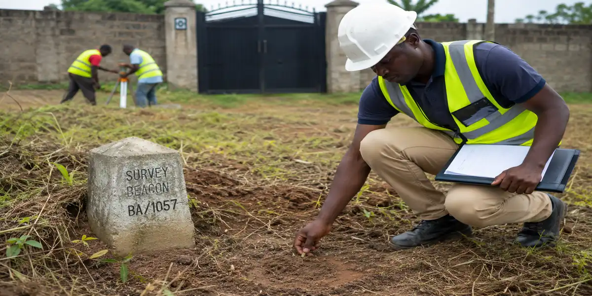
Never let your compound’s finished ground level be decided on-site “by eye.” Insist on a proper level survey before filling begins, with the fall direction marked on the drawing and checked again after filling is complete, before you pave or landscape over it.
Your Drainage Plan: What Should Actually Be On It
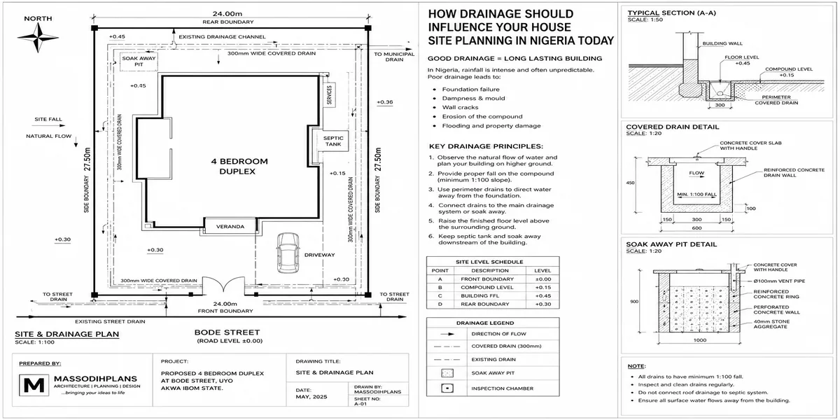
A drainage plan is a specific drawing separate from your architectural floor plan that shows exactly how water moves across your entire plot, not just inside the building. If your architect or contractor has never shown you one, you don’t yet have a finished design; you have a building without an exit strategy for rain.
A real drainage plan should show:
- Contour or spot levels across the plot (the actual ground heights, not assumed ones)
- Direction of surface fall for every paved and landscaped area
- Location and size of every drain, channel, and soakaway
- The point(s) where water leaves your plot, and what it connects to
- How roof rainwater (downpipes) is collected and routed separately from ground-level surface water, ideally
- The overflow route for a rainfall event beyond design capacity
If you’re reviewing a plan and none of this is on it, ask for it before construction starts. Adding drainage after the compound is filled, paved, and fenced is dramatically more expensive than designing it in from day one.
Flood Risk: What It Actually Means for Your Specific Plot
“Flood risk” gets thrown around as a single label, but it’s really a combination of three separate factors, and knowing them separately helps you actually understand your own exposure instead of just being generally worried.
Hazard — is there a physical source of flooding near you: a river, a drainage channel, a low-lying catchment, coastal tidal influence, or simply a history of the area holding water after rain?
Exposure — is your specific building or asset actually positioned within reach of that hazard? A plot two streets from a river on higher ground has different exposure from a plot backing directly onto the same river’s floodplain.
Vulnerability — how much damage would that flooding actually cause, given your building’s design, ground floor level, and the value of what’s inside it? A house with its ground floor raised 60cm above the surrounding grade and no basement is far less vulnerable to the same flood event than an identical house built flush with the ground.
Flood risk is the combination of all three not just “is there a river nearby.” This is why two houses on the same street, a few plots apart, can have genuinely different real flood risk once you account for ground level, drainage connection, and building design, even though a generic “flood zone” map would treat them identically.
How to Actually Assess Flood Risk for a Plot Before You Build
A proper flood risk assessment blends official data with a physical site read, and you can do a meaningful first pass yourself before ever paying a consultant.
Step 1 — Check official flood outlook data.
The Nigeria Hydrological Services Agency (NIHSA) publishes an Annual Flood Outlook every year, identifying high, moderate, and low flood risk states and, increasingly, specific communities. The 2026 outlook found 14,118 communities across 266 Local Government Areas falling within high flood-risk zones, with a further 405 LGAs across 35 states facing moderate risk. This is a starting reference, not a plot-specific verdict check it for your state and LGA before anything else. Stormwater drainage in urban development
Step 2 — Talk to people who’ve lived there through at least one rainy season.
Long-term neighbours will tell you, in five minutes, whether that particular street “always floods a bit in September” information no map will ever capture as precisely as lived experience.
Step 3 — Physically observe the site during or right after rain.
If you can, visit the plot during an actual downpour, or the day after a heavy one. Look for: standing water and how long it takes to clear, visible flow paths across the ground, and any obvious low points relative to the street level.
Step 4 — Check the plot’s elevation relative to its immediate surroundings.
Not just its general area. A plot sitting even 20–30cm lower than its neighbours, on an otherwise “safe” street, quietly inherits everyone else’s runoff.
Step 5 — Get a proper hydrological/geotechnical assessment for any significant project.
Beyond a personal home, any estate-scale or commercial development should commission an actual professional flood risk assessment, not rely on the informal steps above alone.
The single most reliable flood-risk indicator I’ve found on countless site visits isn’t a map it’s asking to see the drainage channel nearest the plot and checking, physically, whether it’s actually maintained, sized adequately, and unobstructed. A “low risk” area with a blocked, undersized drain right beside it is not actually low risk.
Flood Mapping and Flood Zone Maps: What They Show, and What They Quietly Leave Out
A flood zone map is a visual tool showing which geographic areas are classified by flood probability usually color-coded by risk level (high, moderate, low). In Nigeria, NIHSA maintains flood risk mapping tools and coordinates with state emergency management agencies to communicate this data publicly, especially during the Annual Flood Outlook release.
Here’s what almost nothing else online tells you about using these maps: they’re built at a scale that can hide plot-level reality. A flood zone map covering an entire LGA can mark a wide area as “moderate risk” while, within that same area, individual streets sit at meaningfully different real risk because of local drainage condition, ground elevation, and how recently the area was developed. The map tells you the neighbourhood’s general exposure. It does not, and cannot, tell you what a specific undersized culvert two streets away is doing to your specific plot.
Use flood zone maps as a first filter, not a final answer. If your area shows moderate or high risk, that’s a strong signal to commission a proper site-specific assessment. If it shows low risk, that’s useful context but it is not a substitute for physically checking your plot’s own drainage connection and elevation, especially in newly developing parts of Nigerian cities where mapping data often lags behind actual ground changes.
Flood Management, Flood Prevention, and Flood Mitigation — Three Different Jobs
These three terms get used as if they mean the same thing, and treating them as synonyms is exactly how projects end up under-planned. They’re actually three distinct layers of response, and a genuinely resilient property or development needs all three, not just one.
Flood prevention is stopping the flood from happening at all proper drainage sizing, maintaining channels, controlling upstream development that would otherwise overload downstream capacity. This is the layer everyone wants to invest in and the one most consistently under-funded, because its success is invisible: a flood that never happened generates no headlines and, often, no budget line either.
Flood mitigation is reducing the damage a flood causes when prevention still isn’t enough raised floor levels, flood-resistant building materials at ground level, elevated electrical points, and site grading that channels water away from structures even during an extreme event that exceeds the drainage system’s design capacity.
Flood management is the broadest layer the ongoing coordination of monitoring, early warning, emergency response, and recovery planning, typically run by agencies like NIHSA (hydrological forecasting) and NEMA/state emergency management agencies (response and evacuation) working together, rather than something any single property owner controls directly.
For your own project, this breaks down simply: prevention is what your drainage design should achieve on a normal rainy day. Mitigation is what your building’s own design should absorb on the bad day when prevention alone isn’t enough. Management is the layer above both, which you can only really engage with by staying informed and following official advisories, not by building anything yourself.
Erosion Control and Erosion Risk: The Flooding Conversation Nobody Finishes
Most flooding content stops at “water sits on the ground” and never follows the water to what it does to the soil underneath. That’s a real gap, because in large parts of Nigeria, erosion is the slower, more permanently destructive twin of flooding.
Gully erosion, common across South-East Nigeria (Anambra, Imo, Abia, Enugu, Ebonyi in particular), happens when concentrated, uncontrolled runoff repeatedly cuts the same channel into loose or sandy soil, deepening it over years until it becomes a genuine chasm capable of swallowing roads and buildings. It is almost always triggered, or badly worsened, by poorly planned surface drainage water deliberately or accidentally concentrated into one uncontrolled path instead of being spread and slowed.
Coastal and riverbank erosion, more common across the Niger Delta and South-South coastline (parts of Akwa Ibom, Bayelsa, Delta, Rivers), happens through wave action and tidal movement gradually eating into land, a process climate-driven sea level pressures are actively accelerating.
Sheet and rill erosion are the quieter, everyday versions thin, widespread soil loss across sloped, exposed ground, and small emerging channels that haven’t yet become a full gully. These are the easiest and cheapest stage to intervene at, and the stage almost nobody bothers to intervene at, because the damage looks minor until it very suddenly isn’t.
Practical Erosion Control Measures at Plot and Estate Level
Never discharge concentrated stormwater directly onto bare, sloped, or sandy ground. Always direct it into a lined channel or a defined, vegetated, or armored discharge point.
Retain existing vegetation on slopes wherever possible root systems bind soil in a way that no engineered structure fully replicates at the same cost.
Use check dams, terracing, or gabion structures on sites with genuine slope and known erosion history, rather than assuming a simple concrete drain will be enough.
Avoid indiscriminate sand mining and unregulated excavation nearby, which is a major, under-discussed contributor to accelerated gully formation in several South-East states.
Re-vegetate any bare soil left exposed after construction as quickly as possible exposed soil after building work is one of the most common, entirely avoidable triggers of new erosion channels.
If your project sits in a known gully-erosion-prone state or a coastal erosion zone, get a geotechnical/erosion risk opinion before finalizing site grading this is a case where skipping a relatively small assessment fee has, repeatedly, led to genuinely catastrophic and irreversible site loss.
Where Drainage Fits Inside Environmental Planning
Environmental planning is the broader discipline that decides, at policy and layout level, how land use, drainage, green space, and development density are balanced across a city or region and it’s the layer that determines whether individual drainage designs even have a chance of working together.
A well-run environmental planning process sets things like: minimum permeable surface ratios per plot, protected drainage easements that development is not allowed to encroach on, designated flood-retention or green buffer zones, and density limits calibrated to what the existing drainage infrastructure can actually absorb. Where this layer is weak or poorly enforced a genuine, common challenge across rapidly growing Nigerian urban areas individual plots end up fighting a losing battle: your perfectly designed drainage system still floods because the environmental planning layer above it never accounted for how many other plots would eventually drain into the same undersized channel.
This is also, practically, the layer where your Town Planner and your Architect need to be talking to each other, not working in isolation a recurring theme across everything on this site, because so much avoidable damage traces back to exactly that missing conversation.
Environmental Impact Assessment (EIA): When You Actually Need One, and What the Process Looks Like
An Environmental Impact Assessment evaluates the likely environmental, social, and health effects of a proposed project before it’s approved to proceed and in Nigeria, it isn’t optional paperwork for large projects; it’s a legal requirement under the Environmental Impact Assessment Act, enforced primarily through the Federal Ministry of Environment and NESREA.
Which Projects Actually Need One
Nigerian EIA regulation sorts projects into three broad categories: Category I projects (mandatory full EIA typically large-scale infrastructure, major industrial facilities, significant estate developments, mining, and oil and gas projects likely to have major environmental impact), Category II projects (a partial EIA or Environmental and Social Impact Assessment, for projects with moderate potential impact), and Category III projects (generally exempted, typically small-scale residential and low-impact developments).
For most individual homeowners building a single house, a full EIA is not required. Where it becomes relevant is estate-scale residential developments, commercial or industrial projects, and any development in an environmentally sensitive area (wetlands, drainage easements, erosion-prone zones) exactly the projects where drainage failure has the widest knock-on effect on everyone downstream.
The EIA Process Step by Step
Screening — determining which category the project falls into, based on its scale, location, and nature
Scoping — defining exactly which environmental factors (drainage, air quality, ecology, social impact) the assessment needs to cover
Baseline data collection — gathering actual environmental data on the site, often over more than one season, including drainage and hydrological conditions
Draft report preparation and public display — the draft EIA report is displayed for public review, allowing community input, particularly for Category I and II projects
Independent review — a panel of experts and relevant regulators review the draft report and raise queries
Approval and permit issuance — once satisfied, the Ministry issues an EIA approval, often with specific mitigation conditions attached
Ongoing monitoring — approved projects are expected to implement and monitor their mitigation commitments through construction and operation, not just at approval stage
Skipping this process on a project that genuinely requires it isn’t a paperwork risk you can quietly absorb later Nigerian environmental authorities have actively sealed and shut down projects that commenced construction without the required EIA approval, and non-compliance penalties under the Act can run into the tens of millions of naira.
If you’re developing anything beyond a single private home an estate, a commercial plot, a facility near a wetland or drainage channel ask your consultant directly, early, which EIA category your project falls into. Finding this out after significant money has already gone into design and site work is a far more expensive conversation than having it at the very start.
Sustainable Development and Climate-Resilient Cities: Where All of This Is Heading
Sustainable development, in this context, means designing and building in a way that meets present needs without compromising the same land’s ability to absorb, drain, and recover from future rainfall and climate pressure. It’s not an abstract global buzz-phrase it’s the practical difference between a neighbourhood that copes with a heavy rainy season and one that doesn’t, twenty years from now.
Climate-resilient city design increasingly blends a few specific, genuinely applicable strategies:
Sustainable Urban Drainage Systems (SUDS) — designing drainage to slow, store, and filter water close to where it falls (rain gardens, permeable paving, bioswales) rather than rushing it straight into an overloaded pipe network downstream
Protected green and blue infrastructure — deliberately retaining wetlands, natural drainage channels, and vegetated buffers as functioning parts of the drainage system, not obstacles to be filled in and built over
Density matched to infrastructure capacity — allowing development intensity that the actual drainage, road, and power infrastructure can support, rather than approving density first and hoping infrastructure catches up later
Community-based, localized flood forecasting — Nigeria’s hydrological monitoring has been moving toward predictions at the individual community level rather than only broad state-wide alerts, which meaningfully improves how specifically residents can prepare
Building-level resilience as standard practice — raised ground floors, non-absorbent ground-floor finishes, and elevated electrical points treated as ordinary good design, not premium disaster-proofing
None of this works as an add-on bolted onto a finished design. It has to be a starting assumption the same way structural safety is a starting assumption, not something you consider after the walls are already up.
Your Own Plot’s Drainage and Flood Self-Audit
Here’s something genuinely practical you can do this week, whether you’re planning to build or already living in a house. Walk your compound during or immediately after a heavy rain and check, honestly, against this list:
- Does water pool anywhere and take more than a few hours to fully clear?
- Is there any point where water visibly flows toward the building rather than away from it?
- Are your gutters and downpipes actually discharging into a defined channel, or just dumping onto bare ground beside the foundation?
- Is your compound’s drainage channel connected to a working street drain, or does it dead-end?
- Is the street drain outside your plot currently clear, or silted and overgrown?
- Has your neighbour’s recent construction (fencing, filling, paving) changed where water used to flow before it reaches your plot?
- Is any part of your fence or paving sitting inside a drainage easement or road reserve, based on your original survey plan?
- If you have a slope on the plot, is there any visible sign of a new channel or soil loss forming, even a small one?
Any “yes” on the wrong side of these questions is a fixable problem today that becomes a genuinely expensive one structural, legal, or both the longer it’s left unaddressed.
What Getting Drainage Right Actually Costs
Because budget is always the real question behind these decisions, here’s a realistic sense of what proper drainage adds to a typical residential plot in Nigeria, separate from your main building cost:
Basic surface drainage (graded compound, simple channel drains to street, roof downpipe routing): roughly ₦800,000 – ₦2,500,000, depending on plot size
Soakaway construction (where no functioning street drain connection exists): roughly ₦400,000 – ₦1,200,000 per unit, depending on soil condition and required capacity
Proper site leveling/grading survey before filling: roughly ₦150,000 – ₦400,000
Erosion control measures on a sloped or erosion-prone plot (lined channels, basic terracing): roughly ₦500,000 – ₦2,000,000+, depending on severity
Professional hydrological/flood risk assessment for a significant or estate-scale project: costs vary widely by scope, but should be treated as a design-stage line item, not an optional extra
Compare any of these figures to the cost of underpinning a flooded foundation, refilling a collapsed gully, or losing an entire compound to erosion, and the actual math becomes very easy.
Common Mistakes I See Repeated Across Sites
Filling and leveling a compound “by eye” instead of with a proper level survey, guaranteeing an invisible reverse fall toward the building
Treating drainage as a finishing-stage afterthought instead of a design-stage requirement shown on its own drawing
Copying a drainage detail from a completely different climate or soil type without checking whether it actually suits local rainfall intensity and soil drainage behaviour
Ignoring the neighbourhood’s shared drainage pattern and designing a plot’s drainage in total isolation from what surrounds it
Skipping the EIA screening question entirely on estate or commercial-scale projects, assuming it only applies to oil and gas or heavy industry
Discharging concentrated runoff onto bare, sloped ground in erosion-prone states, effectively manufacturing a future gully
Frequently Asked Questions
What’s the difference between a drainage system and a drainage plan?
A drainage plan is the drawing it shows how water is intended to move across a plot. A drainage system is the actual built result of that plan: the physical channels, pipes, and soakaways constructed on site.
Can I reduce flood risk without a full engineering study?
Yes, to a meaningful degree, for an individual plot proper grading, a working discharge connection, and basic maintenance of nearby drains solve a large share of household-level flood risk. A full engineering study becomes necessary for larger or higher-stakes projects, or where official flood risk data already flags the area as significant.
Does every building project in Nigeria need an EIA?
No. Individual private homes are generally exempt (Category III). Estate-scale developments, commercial and industrial projects, and anything in an environmentally sensitive location are far more likely to require a full or partial assessment, and this should be confirmed at the very start of planning.
Why does my area flood even though I’m nowhere near a river?
Urban flooding is very often caused by overloaded or blocked drainage systems and poor surface grading rather than proximity to a river a plot on high ground can still flood badly if the local drainage network is undersized or obstructed.
Is erosion control the same thing as flood control?
No, though they’re closely related. Flood control manages standing or flowing water volume. Erosion control specifically manages the soil loss and channel-cutting that concentrated runoff causes over time a plot can have well-managed flooding and still be actively eroding, if runoff is discharged onto unprotected ground.
Finally, my people
Drainage isn’t the exciting part of a building project, and that’s exactly why it gets skipped, rushed, or left to guesswork more than almost anything else in construction. But it’s the one system where a small, invisible mistake at the planning stage a wrong fall direction, an unchecked discharge point, an unasked EIA question quietly compounds into the kind of damage that no amount of good architecture or interior finishing can fix afterward. Treat it as its own design discipline, ask for its own drawing, and check it against your neighbours and your street, not just your own fence line.
If you’re planning a project and want drainage and site-context genuinely resolved from the start, our Services page outlines how we approach this alongside architectural and planning work. Browse our Plans Library for designs developed with real Nigerian site and drainage conditions in mind, or visit Plan School to understand how site and environmental considerations feed into a proper building plan. You can also explore more planning and building guides on our Homepage.
- How Much Does Home Renovation Cost? A Practical Guide to Remodeling and Home Improvements
- Interior Home Design: How to Plan Beautiful Rooms, Layouts and Decor
- Roofing Problems Solved: Roof Design, Costs, Materials and Installation Now
- Foundation Problems, Types, Cost and Design for Safe House Construction
- Structural Engineering: How to Fix Common Structural Problems for Buildings
- Land Use: How Is Land Used? Planning, Mapping, Zoning and Development
Author
Massodih Okon is a Nigerian built-environment professional with academic and professional experience in urban and regional planning, geography, architectural design, Landscape Design, GIS and land development.
He holds a Master’s degree in Urban and Regional Planning from the University of Uyo and a first degree in Geography and Regional Planning.
Through MassodihPlans, he publishes practical guides on Nigerian house plans, building design, physical planning, site planning, development approval and residential construction. Read the full author profile →