Land and Plot Guide: How to Choose
A client called me two years ago, almost in tears. He had sent money from Aberdeen to a “trusted” family friend to secure a plot in Uyo. The friend paid, took a receipt, and even sent photos of the land with a small signboard planted on it. Eighteen months later, when my client finally flew home to start building, another family showed up with their own documents claiming the same plot and a survey showing his signboard was actually sitting 40 metres off the land he had actually paid for.
That story isn’t rare. It’s Tuesday. And almost every version of it traces back to one of five things: no proper survey, no title verification, no understanding of land use restrictions, no idea how the land was actually valued, or documents that were never registered. This guide exists to close all five gaps at once, in plain language, the way I’d explain it to a client sitting across my desk not the way a law textbook would.
Land for Sale: What You’re Actually Looking At Before You Pay Anyone
When you see “land for sale” advertised on a signboard, in a WhatsApp group, on a real estate site you are looking at one of several very different things, and the difference matters enormously:
Government-allocated land allocated by the state through its land bureau or ministry, usually already surveyed and sometimes already has an approved layout
Estate/developer land sold by a private real estate company that has (ideally) already secured title and subdivided a larger parcel into plots
Family/community land sold by a family or community that holds customary rights over the land, often the riskiest category because multiple family members may claim authority to sell
Resale from an individual owner a plot someone already owns and is reselling, which should come with existing title documents you can verify
The advert rarely tells you which category you’re dealing with. Your first job, before anything else, is to find out because that single fact determines every other step in this guide.
Note Please What to Look For: A seller who volunteers their documents before you ask, invites you to verify at the land registry, and isn’t in a rush to collect deposit “before another buyer comes.” Genuine sellers with clean title are rarely in a hurry.
Plot of Land vs. Land Property: Getting the Terms Straight
People use these interchangeably, but understanding the distinction helps you ask sharper questions.
A plot of land refers to a specific, measured parcel usually already subdivided from a larger area, with defined boundaries, whether or not it has been built on yet. When someone says “I bought a plot,” they mean a specific bounded piece of land, not land in general.
Land property is a broader term covering any land held as an asset a plot, a farm, an undeveloped parcel, or land with an existing building on it. Every plot is land property, but not all land property is a single, ready-to-build plot.
Why this matters: when you’re told a piece of “land property” is available, always ask whether it has already been demarcated into a specific plot with known dimensions, or whether it’s a larger, undivided parcel you’d need to survey and subdivide yourself. These are very different transactions with very different costs attached.
Residential Land vs. Commercial Land: Why This Isn’t Just a Label
This is the mistake I see even experienced buyers make: assuming that once you own land, you can use it however you want. You can’t. Every piece of land in a planned area carries a designated land use classification, and this classification is set before you ever bought the plot.
Residential land is zoned for housing single-family homes, duplexes, or in some zones, low-rise apartment blocks, depending on the density classification. Commercial land is zoned for business use shops, offices, hotels, event centres. Some zones permit mixed use; many don’t.
Here’s the practical problem this causes: I’ve handled cases where a client bought land, assumed it was fine because “everyone builds shops around here,” and only discovered during building plan approval that the land was zoned strictly residential meaning the shop design he’d already paid an architect to draw had to be scrapped, or he had to go through a separate, often expensive rezoning application before proceeding.
Please Dont Forget to Stop and Verify: If a seller or agent brushes off your question about zoning with “it doesn’t matter, just build what you want” that is precisely the answer that should make you verify independently at the planning authority before you pay anything.
Building Plot and Building Land: Confirming It’s Actually Buildable
Not every plot that’s for sale is automatically suitable for building. Before you commit to any “building plot,” confirm these specific things, which many buyers skip entirely:
Soil condition waterlogged, reclaimed, or heavily sandy soil affects foundation type and cost significantly, and this is invisible from a casual site visit in dry season
Access is there an actual motorable road to the plot, or just a footpath that “will become a road eventually”? I have seen buyers discover, after paying in full, that the only access to their plot runs through another family’s land
Drainage does the plot sit in a natural water flow path? Land that looks fine in January can be a lake in July
Setback and plot coverage rules the planning authority’s rules on how far you must build from the boundary, which determines how much of the plot you can actually build on
A plot with clean title but poor soil, no real access, or a flood-prone position is not a “building plot” in any meaningful sense it’s a liability with a nice signboard.
Land Development: What Happens Between Buying and Building
Land development is the broader process of turning raw land into a usable, serviceable state roads, drainage, sometimes water and power infrastructure before individual plots are sold or built on. When you buy into an estate, you’re essentially paying, in part, for development that a developer has (or hasn’t) actually completed.
This is where I tell every diaspora client the same thing: visit the site yourself, or send someone you trust who isn’t the person selling to you. Photos of “ongoing estate development” can be from a completely different section of a much larger, mostly undeveloped parcel. Ask specifically: are internal roads graded and passable in the rainy season? Is there an actual drainage system, or just bare earth? Has the promised infrastructure been delivered, or only promised in the brochure?
Land Use, Land Use Planning, and the Land Use Map: The Layer Most Buyers Never Check
This is, in my experience, the single most under-explained topic in Nigerian land-buying content and it’s the one that causes the most expensive regret after the fact.
Land use refers to what a specific piece of land is designated for residential, commercial, industrial, agricultural, institutional, or recreational/green space.
Land use planning is the process by which planning authorities decide and control this designation across a wider area a town, a local government, a whole state balancing housing need, commercial activity, infrastructure capacity, and green space.
A land use map (sometimes called a zoning map) is the actual document showing these designations plotted across an area. Most Nigerian buyers have never seen one, let alone checked it before buying and most sellers will never volunteer that one exists.
Here’s what checking it actually protects you from:
- Buying residential land that later gets surrounded by heavy industrial development, killing your property’s residential value
- Buying land you plan to build a shop on, only to find it’s zoned strictly residential
- Buying land inside a designated setback, drainage reserve, or future road expansion corridor — which means part or all of what you paid for could legally be reclaimed by government later, often with limited or no compensation
What to Look For: A seller or estate developer who can show you an approved layout plan with the land use map clearly marked, matching what they’re telling you verbally. If they can’t produce this, that absence is itself information.
Land Valuation: Why “Market Price” Isn’t the Same as “Fair Value”
Land valuation is the professional process of determining what a piece of land is actually worth and it is not the same thing as whatever figure the seller quotes you, or even what a similar plot “sold for last month” in casual conversation.
Registered estate surveyors and valuers use several recognized approaches, and understanding them helps you ask better questions even if you’re not doing the valuation yourself:
Comparative method comparing recent actual sales of similar plots nearby, adjusted for size, location, and access
Cost method what it would cost to acquire equivalent land and bring it to the same development state
Income method for land with income potential (commercial, rental), based on what income it could generate
What most buyers actually do instead is ask two or three people “how much is land around here,” average the answers, and call that the value. This is how bubbles and overpayment happen, especially with diaspora buyers who aren’t physically present to sense-check numbers against the real local market.
A price that’s noticeably higher than what similar nearby plots have genuinely sold for not asking prices, actual sales especially when the seller pushes urgency (“price is going up next week, pay now”). Urgency and inflated pricing travel together far more often than coincidence would explain.
Land Survey and Property Survey: The Document That Actually Defines What You’re Buying
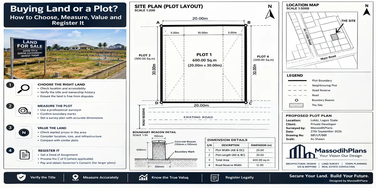
A land survey (also called a property survey) is a professional exercise carried out by a registered surveyor to determine and document the exact boundaries, dimensions, and coordinates of a specific piece of land. The output is a survey plan a drawn document with beacon coordinates, plot dimensions, and a unique survey plan number, registered with the state surveyor-general’s office.
This is not the same as a sketch someone draws by hand, and it is absolutely not the same as a seller simply pointing at boundary trees or a fence and saying “this is your land.” I cannot count how many disputes I’ve seen unravel from exactly that scenario verbal boundary pointing with no professional survey behind it.
Before you pay for any plot, insist on seeing (and ideally independently verifying) the survey plan, and confirm:
The survey plan number is genuine and registered this can be verified at the state’s surveyor-general’s office
The coordinates on the survey plan match the actual physical location you’re being shown yes, this happens: buyers get shown one plot and the survey plan describes a different one entirely
The plan is recent, or at least still accurately reflects current boundaries older surveys can be affected by encroachment over time
Land Measurement, Plot Measurement, and Plot Size: The Numbers Everyone Assumes and Nobody Checks
Land measurement and plot measurement refer to the actual physical dimensions of the parcel length, width, and total area verified on the ground, not just quoted verbally.
Plot size varies more across Nigeria than most buyers realize, which is exactly why assuming a “standard” size without checking is a costly habit:
The most common informal standard used in many parts of Nigeria is 50ft x 100ft (approximately 15.2m x 30.5m), roughly 463.6 square metres
In Lagos and several other urban centres, the common standard shifts to 60ft x 120ft (approximately 18.3m x 36.6m), roughly 648 square metres
Estate developers frequently set their own plot sizes for a specific layout, which may differ from both of the above
Because there is no single nationwide legal “standard plot size,” the only number that actually matters is the one confirmed on your specific survey plan, measured on the ground, matching what you were told before payment.
Land size conversions worth keeping in your head:
- 1 acre ≈ 4,046.86 square metres, roughly six plots at 60ft x 120ft
- 1 hectare = 10,000 square metres ≈ 2.47 acres
- 1 plot at 60ft x 120ft = 648 square metres; at 50ft x 100ft ≈ 463.6 square metres
Never accept “it’s a full plot” as a description. Ask for the exact dimensions in feet or metres, and if possible, walk the boundary with a tape measure or GPS app yourself before paying anything, comparing what you measure against the survey plan’s stated figures. A shortfall of even a few metres on one side, multiplied across the whole plot, is real money and real space you’re not getting.
Property Boundary and Property Boundary Survey: Where Most Neighbour Disputes Actually Start
Your property boundary is the legally defined edge of your plot, as recorded on your survey plan not the fence, wall, or line of trees currently marking it on the ground, which can shift over time through encroachment, erosion, or simple human error during construction.
A property boundary survey is the specific exercise of a registered surveyor physically locating and marking (or re-establishing) these legal boundary points on the ground, using the coordinates from the registered survey plan, and placing or confirming boundary beacons.
Here’s the practical issue almost nobody explains: boundary beacons get moved, buried, or destroyed over time sometimes by accident during construction nearby, sometimes deliberately by a neighbour quietly expanding their own plot. If you build your fence based on “where it’s always been” rather than a fresh boundary survey against your registered plan, you risk either losing part of your own land to encroachment, or unknowingly building onto a neighbour’s land yourself which creates a legal problem for you, not them, once it’s discovered.
Before you build any fence or start construction, especially on land you didn’t personally see surveyed, commission a fresh boundary survey against your registered plan rather than relying on existing beacons, fences, or a neighbour’s assurance about “where the line has always been.”
Land Title and Property Title: What You’re Actually Being Given
Land title (used interchangeably with property title) refers to the legal document(s) proving your right to own or occupy the land. In Nigeria, because of the Land Use Act of 1978, this is more layered than in many other countries, and understanding the layers is essential.
Under the Land Use Act, all land in a state is technically vested in the Governor, held in trust for the people. What individuals and organizations actually hold is a right of occupancy statutory (in urban areas) or customary (typically rural/traditional land) evidenced by specific documents. The transfer of any interest in land legally requires the Governor’s consent, and per the Act, a transaction completed without that consent can be treated as void.
The main title documents you’ll encounter, and what each actually means:
Certificate of Occupancy (C of O) the strongest, most recognized evidence of a statutory right of occupancy, typically granted for a term (commonly up to 99 years, renewable), issued by the state government through its land bureau or ministry
Deed of Assignment the legal document transferring an existing interest in land from a seller to a buyer; on its own, without registration and Governor’s consent, it does not complete a legally protected transfer
Governor’s Consent the formal approval required under the Land Use Act before a transfer of a right of occupancy is legally valid; without it, per the Act, the transaction can be treated as null and void
Excision and Gazette for land carved out of larger family or community-held areas and formally released by government for private allocation, evidenced by publication in the state’s official gazette; land without excision, even if a family “sold” it in good faith, can carry serious title risk
Governor’s Allocation/Letter of Allocation issued when land is directly allocated by government, often the starting document before a full C of O is eventually processed
A title document with an impressive-sounding name is not automatically valid. What actually protects you is whether it’s genuine, properly executed, and critically registered.
Land Registration and Property Registration: The Step That Actually Protects You
Land registration (or property registration) is the act of officially recording your title document at the relevant state land registry, which is what gives your ownership legal protection against competing claims and third parties.
This is the step my client from the opening story never confirmed. His “friend” had paid for the land and had a receipt but a receipt is not a registered title. Registration is what creates the official public record that says, unambiguously, that this specific parcel now belongs to this specific person.
The general practical sequence, though it varies somewhat by state:
- Conduct a title search at the state land registry to confirm the seller’s existing title is genuine and free of encumbrances (mortgages, pending litigation, competing claims)
- Verify the survey plan and, ideally, commission an independent boundary survey
- Draft and execute a Deed of Assignment through a qualified legal practitioner
- Apply for the Governor’s Consent, submitting the Deed, existing title documents, and required fees — this step commonly takes weeks to a few months depending on the state
- Register the completed, consented documents at the land registry
- Where applicable, proceed to apply for your own Certificate of Occupancy
“We’ll sort out the registration later, just pay first and I’ll give you the documents” is one of the most common phrases attached to land fraud in Nigeria. Registration isn’t paperwork you get around to eventually it’s the actual protection the entire transaction exists to secure. Treat an unregistered “sale” as unfinished, however much money has changed hands.
The Layer Almost No Land-Buying Guide Covers: Red Flags Specific to Nigerian Land Transactions
Beyond the standard advice repeated everywhere, here are patterns I’ve seen repeatedly in real disputes, that rarely make it into generic checklists:
Multiple “omo onile” claims in many communities, several individuals may each present themselves as authorized to sell or demand fees on the same family land. A genuine sale should be backed by documented family or community authority, not one person’s word.
Same land, different buyers, years apart a plot sold once, quietly resold to someone else years later while the first buyer never developed it. Regular site visits and prompt development after purchase reduce this risk significantly.
“Free” family land with informal receipts only extremely common, and extremely risky, because informal family arrangements rarely survive a change in family leadership or a dispute among heirs.
Government acquisition notices some land, even with plausible-looking documents, sits within land already earmarked by government for future roads, drainage, or public projects. A search at the relevant ministry can reveal acquisition notices that a seller conveniently never mentions.
Diaspora-specific exposure buying and paying entirely through intermediaries without ever independently verifying documents or visiting in person is, in my experience, the single largest predictor of diaspora land fraud cases. Where a personal visit isn’t possible, engage your own independent lawyer or surveyor not one recommended by the seller to verify on your behalf.
A Practical Land-Buying Checklist
- Confirm exactly which category of land this is government, estate, family, or individual resale
- Verify the land use/zoning classification matches your intended purpose
- Insist on seeing the registered survey plan and independently verify its plot number
- Physically measure or independently verify the plot dimensions against the survey plan
- Conduct a title search at the state land registry before paying anything
- Confirm there’s no pending government acquisition on the land
- Verify boundary beacons on the ground match the survey plan’s coordinates
- Use an independent lawyer to draft or review the Deed of Assignment
- Confirm the Governor’s Consent process is actually completed, not just “in progress” indefinitely
- Complete registration at the land registry before considering the transaction finished
Frequently Asked Questions
What is the difference between a Certificate of Occupancy and a Deed of Assignment?
A Deed of Assignment transfers an existing interest in land from seller to buyer. A Certificate of Occupancy is the government’s own grant of a statutory right of occupancy. You can hold a Deed of Assignment for land that already has a C of O, or apply for your own C of O afterward.
Is a receipt enough proof that I own land in Nigeria?
No. A receipt only shows that money changed hands. Legal protection comes from a properly executed, consented, and registered title document not a receipt.
How do I know the standard size of a plot before buying?
There is no single nationwide standard it varies by state and by estate. Always confirm the exact dimensions on the specific survey plan for the plot you’re buying, rather than assuming a “standard” figure applies.
Can I build anything I want once I own the land?
No. What you can build is governed by the land’s zoning/land use classification, plus setback and plot coverage rules from the relevant planning authority this applies regardless of what you personally intend or what neighbours have already built.
What happens if I buy land without a proper survey?
You risk boundary disputes, buying less land than promised, or discovering the plot you were shown doesn’t match any registered survey plan at all all of which are far cheaper to catch before payment than to resolve afterward.
Finally
Every serious land dispute I’ve handled traces back to a step someone skipped to save time or avoid an awkward conversation with a seller usually the survey verification, the title search, or the registration. None of these steps are complicated once you know they exist; they’re simply the ones sellers rarely bring up first, because the honest sellers don’t need to and the dishonest ones would rather you didn’t ask.
If you’re currently evaluating land for a project, our Services page outlines how we support clients through site verification and planning approval, not just design. Browse our Plans Library for house designs matched to standard Nigerian plot dimensions, or visit Plan School to understand how planning approval connects back to the land use and title status covered here. You can also explore more land and building guides on our Homepage. Read these also:
- How to Create a Site Plan: Site Analysis, Layout and Development Guide Today
- Construction: A Complete Guide to Building Projects, Materials and Services
- Building Cost and Construction Cost: How Much Will Your House Really Cost?
- House Plans and Floor Plans: How to Choose the Right Layout for Your Needs
- My Tenant Won’t Leave. What Can I Do? Legal Steps for Landlords in Nigeria and Beyond
Author
Massodih Okon is a Nigerian built-environment professional with academic and professional experience in urban and regional planning, geography, architectural design, Landscape Design, GIS and land development.
He holds a Master’s degree in Urban and Regional Planning from the University of Uyo and a first degree in Geography and Regional Planning.
Through MassodihPlans, he publishes practical guides on Nigerian house plans, building design, physical planning, site planning, development approval and residential construction. Read the full author profile →