How to Use Satellite Maps to Study Land Before Buying Property in Nigeria
Let me tell you about a call I got a few years back. A man had already paid for a plot near a fast-growing axis outside Uyo. Beautiful dry-season photos, agent swore the land was “solid ground, no flooding.” He called me not to celebrate but to ask why, three months into the rains, water was sitting ankle-deep in what was supposed to be his living room foundation trench. We pulled up satellite imagery of that same plot from two different rainy seasons. Both years, that spot sat under standing water for weeks. The information had been sitting in plain sight, free, before he ever handed over a naira. Nobody had looked.
That’s really what this article is about. Not the general “verify your documents” advice you’ve read fifty times that advice is correct, but it’s not enough on its own, and I’ll explain exactly why further down. This is about the part almost nobody walks you through properly: how to actually read satellite imagery like someone trained to read land, so it tells you things a survey plan and a site visit alone won’t.
Why a Site Visit Alone Doesn’t Tell You What You Think It Does
Here’s something I need you to sit with for a second. When you visit land in the dry season which is when most sales inspections happen — you are looking at that plot in its best possible condition. Dry ground looks solid regardless of what it does in July. A gentle slope looks harmless until you see where all that water from three streets away is funneled during a downpour. A quiet bush plot looks empty until you realize it sits inside a drainage channel the government marked out on paper fifteen years ago and never fenced.
A single site visit gives you one frozen moment. Satellite imagery, used properly, gives you a timeline. And a timeline is what actually protects you, because land doesn’t lie about its history only people do.
Never let a seller or agent choose which season to show you the land. If you can, insist on seeing satellite imagery from both dry and rainy season before you commit this single habit alone would have saved that client I mentioned above a lot of money and heartbreak.
What Satellite Maps Can Actually Tell You (That a Survey Plan Cannot)
A survey plan tells you the shape, size, and legal coordinates of a plot. It does not tell you what happens on that land when the sky opens. Satellite imagery fills that specific gap. Here’s what you’re actually looking for, and why each one matters.
1. Standing Water and Flood History
Open the same coordinates across different months and different years, and you’re looking for dark, pooled patches that appear repeatedly during rainy months and disappear in dry ones. That pattern not a one-time flood, but a recurring one is the strongest signal that a plot sits in a natural water collection point, regardless of what anyone tells you on-site.
2. Drainage Channels and Water Flow Direction
Look at the land around your plot, not just the plot itself. Water moves downhill and along the lowest visible paths you can often trace these as faint darker lines or vegetation changes running across multiple plots toward a stream, canal, or low point. If your plot sits along that natural path, you have effectively bought a drainage channel with a fence around it, whether the government has officially marked it or not.
3. Erosion Gullies and Soil Movement
This one matters enormously if you’re looking anywhere in the South-East or parts of South-South Nigeria, where gully erosion is a real and growing threat. On satellite imagery, active erosion often shows up as a jagged, branching scar cutting into otherwise flat or gently sloped land sometimes small on one image and visibly larger a year or two later on a newer one. Comparing the same spot across a few years’ imagery tells you whether that gully is stable or actively eating land, which a single dry-season visit will never reveal.
4. Vegetation Cover and What It’s Hiding
Dense, unusually green vegetation in an otherwise dry surrounding area is frequently a sign of underground water sometimes a swamp, sometimes a spring, sometimes just naturally waterlogged soil. This matters directly for your foundation cost, because waterlogged soil often means you’re looking at a raft or pile foundation instead of a standard strip foundation, a difference that can run into millions of naira.
5. Access Roads That Actually Exist (Versus Promised)
Agents love to describe land as having “a good access road coming soon.” Satellite imagery shows you what access road actually exists today its width, whether it’s a real vehicular road or a footpath, and how far it is from where you’re standing on the ground. If the imagery shows bush between your plot and the nearest real road, that gap is your problem to solve, not a future promise to bank on.
6. Neighbouring Land Use and Development Pattern
Zoom out and look at what’s actually around the plot is it surrounded by completed homes, by bush, by an industrial layout, or by a swamp that hasn’t been touched because everyone locally already knows not to build there? Local knowledge often shows up visually before anyone tells you about it in words, and a plot that’s suspiciously undeveloped while everything nearby is built up is worth asking hard questions about.
7. Government Reserves, Setbacks, and Acquired Land
High-tension power line corridors, major drainage easements, and road reserves often show up on satellite imagery as consistent unbuilt strips cutting through otherwise developed areas, even where no visible signage exists on the ground. If your plot sits inside or touches one of these strips, that’s a red flag worth chasing down at the relevant planning office before you go any further, regardless of what the seller’s documents claim.
Satellite imagery can show you a pattern worth investigating it cannot, on its own, prove or disprove legal ownership, government acquisition status, or title validity. It’s a screening tool that tells you where to dig deeper, not a substitute for the Surveyor-General’s charting process or a proper title search. Use both.
The Actual Step-by-Step Workflow I Use
This is the part most articles skip entirely, so let’s get specific.
Step 1: Get the Real Coordinates, Not Just an Address
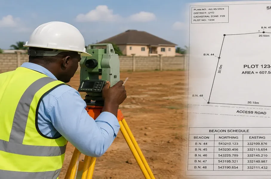
Ask the seller or agent for the beacon coordinates from the survey plan not just “it’s along XYZ road.” Coordinates let you locate the exact plot on satellite imagery precisely, instead of guessing based on a vague description that could shift your search by an entire street.
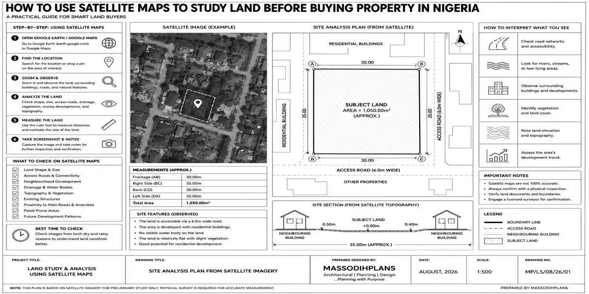
Step 2: Plot the Coordinates on Google Earth (Desktop, Not Just the App)
Google Earth Pro on desktop, which is free, lets you type coordinates directly and drop a precise pin something the basic mobile app makes more fiddly. Once you’re on the exact spot, zoom until you can clearly make out the plot boundaries relative to nearby landmarks.
Step 3: Use the Historical Imagery Timeline
This is the single most underused feature in all of this. Google Earth Pro has a clock icon that lets you scroll backward through years of imagery for the same location. Slide through at least three to five years, paying specific attention to rainy-season-dated images where available. You’re checking for: recurring standing water, an erosion scar that’s growing, or vegetation cover that’s changed suspiciously (sudden clearing right before a sale is sometimes used to hide a swampy patch that would otherwise show as unusually green).
Step 4: Cross-Check with a Second Imagery Source
Don’t stop at one provider. Bing Maps’ aerial/bird’s-eye view and even the satellite layer inside Google Maps itself sometimes capture different dates or angles than Google Earth, and comparing two sources helps you catch anything one might have missed or blurred out due to cloud cover which is a real, frequent problem with satellite imagery in Nigeria’s humid climate.
Step 5: Zoom Out and Study the Wider Drainage Pattern
Pull back until you can see at least 500 metres to a kilometre around the plot. Trace where the land visibly slopes toward, where any streams or canals run, and where the built-up areas versus the untouched low-lying areas sit. Your plot’s relationship to this wider pattern matters more than how the plot looks in isolation.
Step 6: Note Everything That Raises a Question, Then Verify It Physically
Satellite imagery gives you a shortlist of things to check on the ground and at the relevant offices not a final verdict. Take your specific observations (recurring wet patch, unusually green corner, unbuilt strip running through the land) to your surveyor and your site visit, and ask direct questions about exactly those spots instead of a generic “is this land okay?”
When you visit the site physically after your satellite review, go stand at the exact spot that looked suspicious on imagery don’t just walk the general plot. I have watched clients get shown a “dry, solid” corner of a plot while the actual low point, twenty metres away, never gets mentioned by the agent doing the walk-through.
Where This Fits With the Due Diligence You Already Know You Need
I want to be honest with you about something: satellite imagery review does not replace title verification, and if you’ve read anything about buying land in Nigeria, you already know the standard steps checking the Certificate of Occupancy or Governor’s Consent, taking the survey plan to the Surveyor-General’s office for charting, confirming the land isn’t under government acquisition, and checking the seller’s chain of title at the Land Registry. Those steps confirm the land is legally yours to buy. What they don’t confirm is whether the land is physically sound to build on and live on. Satellite review is the physical-condition half of due diligence that the legal-verification half was never designed to cover. You genuinely need both, and treating either one as sufficient by itself is how people end up with land they legally own and can never comfortably build on or land that’s physically fine but legally contested.
Common Mistakes People Make With Satellite Maps
Looking at only one image, from one season. A single dry-season snapshot tells you almost nothing about flood risk.
Trusting low-resolution imagery in rural or newly developing areas. Coverage quality genuinely varies across Nigeria, and a blurry patch isn’t automatically “nothing to see” sometimes it’s simply an area that hasn’t been imaged well recently, and that itself is worth noting.
Ignoring the land around the plot. Your plot’s fate is tied to how water and development move across its neighbours, not just what happens inside your own boundary lines.
Treating satellite imagery as proof of ownership. It shows physical patterns, not legal status don’t let a clean-looking satellite image substitute for an actual title search.
Not cross-referencing coordinates carefully. A wrongly entered coordinate can have you confidently studying the wrong plot entirely, sometimes streets away from the real one.
Frequently Asked Questions
Can satellite maps show me if land floods without visiting during rainy season?
Yes by comparing the same coordinates across several rainy-season-dated images over multiple years, you can spot recurring standing water without ever needing to be physically present during the rains yourself.
Is Google Earth accurate enough for checking land in Nigeria?
It’s accurate enough for pattern-level screening flooding, erosion, vegetation, access, neighbouring development but image resolution and update frequency vary by area, so always cross-check with a second source and a physical site visit before making a final decision.
Can I measure my plot size using satellite maps instead of hiring a surveyor?
You can get a rough estimate using tools like Google Maps’ distance measurement, but satellite imagery carries positional inaccuracy and dating limitations that make it unreliable for anything beyond a quick sanity check never use it in place of an actual professional survey for negotiation or title purposes.
Does satellite imagery show government-acquired land?
Not directly, but consistent unbuilt strips or reserved-looking corridors visible on imagery can be a signal worth investigating at the relevant state Surveyor-General’s or planning office before you proceed.
What’s the best time of year to check satellite imagery for flood risk?
Rainy-season-dated imagery is what actually reveals flood risk. If historical imagery for your specific location doesn’t include rainy-season dates, that gap itself is worth noting, and you may need to wait for a rainy period or rely more heavily on physical drainage inspection.
Before You Go Further
If there’s one thing I want you to walk away with, it’s this: the information that would have saved that client near Uyo was never hidden. It was sitting freely available on satellite imagery, for anyone who knew to look at more than one photo, taken in more than one season. That’s the whole difference between buying land that quietly becomes a problem and buying land you can actually build the life you’re planning on.
If you’re at the stage of evaluating a plot and want a second, trained pair of eyes on what the imagery and site conditions are actually telling you, our Services page outlines how we support clients through exactly this kind of due diligence. For a broader look at getting your building plan right once the land itself checks out, browse our Plans Library or visit Plan School for the planning and approval steps that come next. You’ll find more practical guides like this one on our Homepage.
Related Posts
- How Wind Direction Can Influence House Planning and Natural Ventilation
- How Sun Orientation Affects Residential Building Design in Nigeria Today
- How Nigeria’s Climate Should Influence Your House Design and Site Planning
- How Natural Water Flow Can Affect Your Building Site and House Plan Today
- How Drainage Should Influence Your House Site Planning in Nigeria Today
- How Topography Influences Flooding Around Nigerian Homes and Cities Today
- How to Understand Land Use Before Buying Property in Nigeria Safely
- How Land Use Affects the Type of Building You Can Develop in Nigeria Today
- 10 Things to Check Before Building a House on Any Plot in Nigeria Today
- How to Evaluate Land in Lagos Before Choosing a House Plan to Build Safely (15 Best Ways)
- How to Choose the Right Residential Location in Abuja Before You Build (20 Best Areas Ranked for Buildability)
- How to Choose the Right Residential Location in Lagos Before You Build
- 10 Best House Plans for Small Plots in Nigeria: What Buyers Should Consider
Author
Massodih Okon is a Nigerian built-environment professional with academic and professional experience in urban and regional planning, geography, architectural design, Landscape Design, GIS and land development.
He holds a Master’s degree in Urban and Regional Planning from the University of Uyo and a first degree in Geography and Regional Planning.
Through MassodihPlans, he publishes practical guides on Nigerian house plans, building design, physical planning, site planning, development approval and residential construction. Read the full author profile →