Why Most Air Force Base Master Plans Fail Before Construction Even Begins
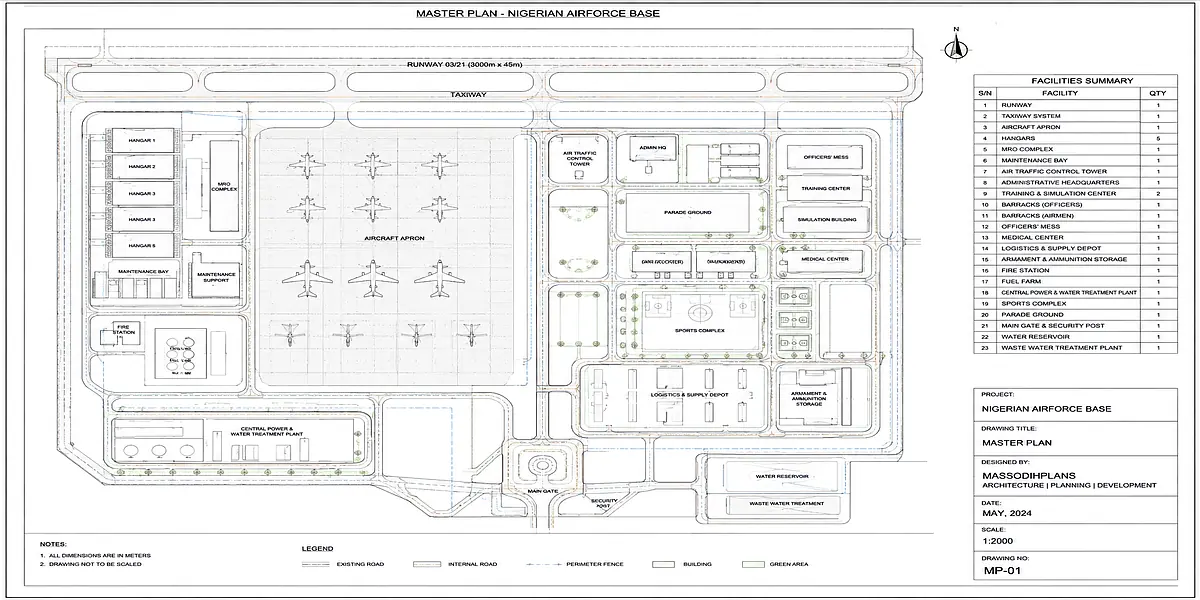
Design of an Air Force Base Master Plan
An air force base master plan works when it balances five things at once: mission readiness, airfield safety, security, quality of life for personnel, and room to grow—all fitted onto a piece of land that can never be redesigned from scratch once the first runway is poured. That’s the short answer. Now let me walk you through why it actually matters, because I have reviewed enough institutional layouts in my planning career to know that most of the mistakes happen quietly, long before anyone notices them on a drawing.
If you are a planning student, a facilities officer, a defence contractor, or just someone curious about how a military installation actually takes shape on paper before it becomes concrete and asphalt, this article is for you. In my experience, people either imagine a base as “just a big airport with soldiers” or as something too classified to understand. Neither is true. The planning logic is public, teachable, and honestly not that different from planning any large institutional campus just with higher stakes for error.
First, What Is an Air Force Base Master Plan?
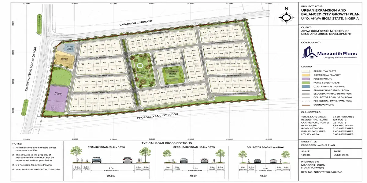
A master plan is the long-range document that decides where every major function on the base goes—the airfield, the hangars, family housing, the hospital, the fuel farm, the perimeter fence, and the roads connecting all of it—usually mapped out for 20 to 50 years ahead. It is not the same as a site plan, which handles one building at a time. A master plan is the skeleton; site plans are the muscles attached to it later.
During my undergraduate studies in Town Planning, one thing our lecturers constantly emphasized was that institutional master plans succeed or fail based on decisions made in the first six months decisions about zoning boundaries, circulation hierarchy, and buffer distances. Once a developer builds a hangar or a barracks block in the wrong zone, correcting it can cost more than building it a second time elsewhere.
Core Principles That Guide the Design
1. Mission Compatibility Comes First
Every zone on the base exists to protect or support flight operations. The airfield is not just one element among many it is the reason the base exists. This means:
- Flight-critical zones (runways, taxiways, aprons) get first claim on the flattest, most obstruction-free land.
- Planners keep anything that generates smoke, dust, glare, or tall structures away from approach and departure paths.
- Planners shield radio and radar-sensitive equipment areas from interference caused by buildings or high-voltage infrastructure.
I have reviewed layout studies where planners proposed administrative buildings close to a runway centerline purely because that land was convenient and already cleared. On paper it looked efficient. In practice, the proposal would have violated obstacle clearance surfaces and forced planners to redesign the entire southern quadrant. This is one of the most common misconceptions I encounter: that “empty land” automatically means “available land.”
2. Safety and Clear Zones Are Non-Negotiable
Every airfield master plan works around defined safety geometries:
Runway Protection Zones / Clear Zones — trapezoidal areas beyond each runway end where planners cannot place habitable structures.
Accident Potential Zones — areas further out with restricted density and use types.
Obstacle clearance surfaces — imaginary sloped planes rising from the runway that no structure, tree, or antenna may penetrate.
From what I have seen in practice, these zones dictate almost everything else on the base map. Planners always place housing, schools, and recreational facilities outward from these envelopes, which is why family housing on most bases sits noticeably far from the flight line not for privacy, but for protection.
3. Security and Perimeter Design
A base is planned in security layers, working outward from the most sensitive assets:
Restricted core flight line, weapons storage, command centers.
Controlled zone administrative and technical buildings requiring ID access.
General access zone housing, schools, recreation, retail.
Perimeter and buffer fencing, lighting, standoff distance from the outer boundary, and controlled entry points.
Based on projects I have worked on involving institutional campus security layering (though civilian, the same zoning logic applies), the biggest planning error is collapsing these layers too tightly to save land. A base that looks compact on a drawing but leaves no standoff distance between the perimeter fence and mission-critical buildings has traded efficiency for vulnerability.
4. Circulation and Access Hierarchy
Roads on a base are planned in a strict hierarchy, and this is where good master planning becomes invisible you only notice it when it’s done badly:
Flight-line service roads restricted, used only by authorized vehicles.
Primary base roads connect major functional zones.
Secondary/residential streets lower speed, higher pedestrian priority.
Emergency and fire access loops planned so no building is more than a set response distance from a fire station.
One lesson I learned early is that circulation planning is really about separation — separating high-security traffic from family traffic, and separating heavy equipment routes from pedestrian routes, long before anyone thinks about paving.
5. Environmental and Noise Buffering
Airfields generate serious noise and, in some cases, fuel-related environmental risk. A good master plan:
- Maps noise contours (measured in decibel bands) and restricts noise-sensitive uses like housing and schools from the loudest zones.
- Plans fuel storage and maintenance areas with contamination containment and safe distance from water sources.
- Considers prevailing wind direction so that noise, dust, and emissions drift away from residential areas rather than toward them.
This is something I have encountered many times in civilian airport-adjacent planning too communities that grew right up against a noise contour boundary because nobody enforced it early, and then spent decades fighting the airport over it. A base master plan has to get this right from day one because there’s no “moving the runway” once it exists.
6. Infrastructure and Utility Capacity
Long before construction begins, a master plan has to size:
- Power supply and backup generation capacity, including resilience for mission-critical loads.
- Water supply, including firefighting reserve capacity (aviation fuel fires need far more water than typical structural fires).
- Fuel distribution networks, sized with growth headroom, not just current demand.
- Stormwater drainage sufficient for large paved surfaces like runways and aprons, which shed water fast and can flood surrounding zones if undersized.
Based on projects I have worked on, undersized drainage is one of the most repeated and most expensive mistakes in any large paved-surface project not just military ones. A runway and its aprons can be tens of hectares of impermeable surface. If the drainage master plan doesn’t account for peak storm flow from day one, you get flooding problems that no later retrofit fixes cheaply.
7. Growth Flexibility
A master plan is a living document, not a finished picture. Good ones reserve:
- Expansion land adjacent to the airfield for future runway extension or additional taxiways.
- Buffer land around housing and support zones for population growth.
- Utility corridors with spare capacity built in, so future expansion doesn’t mean tearing up existing infrastructure.
I once reviewed a plan where every parcel of usable land had already been allocated to a specific building with no reserve zones at all. It looked maximally efficient until the base needed to add a new squadron facility five years later and had nowhere left to put it without demolishing something.
8. Quality of Life and Community Facilities
Personnel welfare zones housing, schools, medical facilities, recreation, dining, retail are planned as a self-contained community, because many bases function almost like small towns:
- Housing is grouped by rank/family type but always outside safety and noise zones.
- Schools and childcare are placed for safe walking access, away from vehicle-heavy roads and flight operations.
- Medical facilities need road access good enough for both routine use and mass-casualty response.
From what I have seen in practice, planners often underestimate how much this “quality of life” layer affects retention and morale a base that is operationally excellent but poorly livable struggles to keep personnel long-term, and that shows up in every retention statistic eventually.
Practical Dimensions, Land Requirements, and Cost Considerations
This is the layer most master-planning expert skips, because it’s easier to talk about “zones” in the abstract than to sit with actual numbers. But in my experience, this is exactly the layer that separates a plan that gets approved and funded from one that just looks good as a concept drawing.
Overall Land Allocation
A functioning air force base master plan, including airfield, support zones, housing, and buffer land, is typically planned on a scale ranging from 400 to over 2,000 hectares, depending on the number of squadrons, aircraft type, and whether the base includes family housing and a full logistics wing.
As a general planning ratio, the airfield itself (runway, taxiways, aprons, and their protection zones) commonly consumes 30–40% of total base land, even though it’s a single functional zone this is why land allocation should always start from airfield geometry outward, not from administrative convenience inward.
Practical tip: always size the airfield zone first, then work outward to support and residential zones. Planners who start with housing or admin blocks first almost always end up compressing the airfield’s safety geometry to make the numbers fit and that’s the one zone that cannot be compressed.
Runway and Airfield Dimensions
And Runway lengths vary by aircraft class, but a standard fighter-capable runway is typically planned at 2,400m to 3,000m long by 45m to 60m wide, with paved shoulders extending the usable width further.
Runway Protection Zones (clear zones) at each runway end are generally trapezoidal, commonly extending 300m outward from the runway end, widening from roughly 150m to 450m across their length depending on approach category.
Taxiways are typically planned at 23m to 30m wide, with a minimum separation of 150–190m from the runway centerline for larger aircraft categories, to keep clearance envelopes intact.
Aircraft parking aprons are sized per aircraft footprint plus maneuvering space as a rule of thumb, each fighter-class aircraft parking position requires roughly 35m x 35m to 45m x 45m of apron space including taxi clearance.
Security Buffer and Perimeter Distances
Standoff distance between the outer perimeter fence and mission-critical structures (command centers, weapons storage, fuel farms) is generally planned at a minimum of 30–45 meters, and considerably more for higher-risk facilities based on site-specific threat assessment.
Perimeter patrol roads are typically planned at a minimum width of 6–7 meters, sufficient for two patrol vehicles to pass without stopping.
Weapons and munitions storage areas follow explosive safety quantity-distance standards, which commonly require separation distances of hundreds of meters from occupied buildings, scaled directly to the quantity and type of ordnance stored this is one of the few zones where the buffer distance is calculated rather than estimated.
Housing and Community Zone Dimensions
Family housing on most bases is planned at residential densities comparable to civilian suburban layouts — typically 300–500 square meters per housing unit including yard space, roads, and shared amenities.
Housing zones are generally set back a minimum of 1.5 to 3 kilometers from the runway centerline, depending on the specific noise contour and accident potential zone mapping for that base.
Schools and childcare facilities within the residential zone are typically planned with walking-distance access no child should need to cross a primary base road to reach school, which shapes the internal road hierarchy of the housing zone directly.
Roof Type and Building Orientation
Hangars and large maintenance structures are typically oriented with their main door frontage facing away from prevailing crosswinds, to reduce wind interference during aircraft movement in and out.
Administrative and accommodation buildings follow the same passive-cooling logic as any institutional building in a hot climate: long axis oriented east-west, roof ridge running east-west, with 600mm–900mm overhangs to shade wall openings from direct sun without blocking natural ventilation.
Pitched roofs (typically 22–30 degrees) with ridge ventilation are generally preferred over flat roofs for occupied buildings, since flat roofs trap significant heat in high-occupancy structures like barracks-style accommodation or mess facilities.
Drainage and Setback Requirements
Stormwater retention capacity for airfield-scale paved surfaces is typically planned at 1.5 to 2 times the capacity that would be used for an equivalent area of ordinary road or parking pavement, because runway and apron surfaces shed water faster and in larger volume during storm events.
Fuel storage and fuel farm areas require containment berms and a minimum separation from water sources and boreholes, commonly specified at 100 meters or more, to prevent contamination in case of leakage.
Cost Considerations
Airfield paving and lighting infrastructure typically represents the single largest cost component of the entire base often exceeding the combined cost of all administrative and housing structures, because of the scale of paved area and the specialized lighting/navigation systems required.
Phasing cost efficiency matters enormously on a project of this scale each construction phase should deliver a functionally complete, independently secure zone, so that a funding gap between phases doesn’t leave critical infrastructure (fuel storage, perimeter fencing, drainage) half-finished and exposed.
Utility oversizing (water storage for firefighting reserve, backup power, drainage capacity) costs considerably more upfront but is far cheaper than retrofitting undersized systems once the base is operational and every retrofit has to work around active flight operations.
Expert note: based on the planning logic I’ve applied across institutional-scale projects, cost overruns on projects like this rarely come from the buildings themselves they come from underestimating perimeter length, drainage capacity, and paved-surface area, all of which scale with total site footprint, not with the number of personnel stationed there.
9. Resilience and Disaster Planning
Modern master plans increasingly build in resilience against both natural and man-made disruption:
- Redundant power and water systems so a single point of failure doesn’t shut down mission-critical operations.
- Hardened or dispersed critical infrastructure, so no single incident can take out multiple key systems at once.
- Evacuation and mass-casualty routing planned into the road hierarchy from the start, not added afterward.
Nigerian Reality Layer
I want to be honest about something most articles from outside Nigeria never touch on, because I have seen it firsthand in institutional and government-adjacent projects across Akwa Ibom, Lagos, Kano, Kaduna and Rivers States.
Power supply realities
Grid power alone is never treated as reliable infrastructure for mission-critical zones. Any Nigerian base-scale master plan has to allocate real physical space not an afterthought corner for generator houses, fuel storage for those generators, and increasingly, solar backup arrays. This space competes with the same land that housing and admin zones want, so it must be planned early, not squeezed in later.
Flooding and drainage
Several parts of Nigeria’s south-south and coastal belts experience heavy seasonal rainfall that overwhelms undersized drainage almost every year. Any large paved surface and a runway apron is about as large and impermeable as paved surfaces get needs oversized stormwater channels and retention areas planned from the very first drawing, not patched in after the first flood.
Unstable material and construction costs
Cement, steel, and imported specialized materials (like airfield lighting systems or specialized pavement materials) fluctuate in price constantly. A master plan built for Nigeria has to be phased deliberately, so that funding gaps between phases don’t leave half-finished zones exposed to security or safety risk.
Heat and ventilation for support buildings
Nigeria’s climate means administrative, medical, and housing zones need genuine passive cooling consideration building orientation, roof overhangs, and natural cross-ventilation because mechanical cooling alone is expensive to run continuously at scale.
Compound and gatehouse security culture
Nigerian institutional planning tends to layer physical security more heavily than some other contexts gatehouses, perimeter walls, and controlled vehicle checkpoints are planned as substantial zones, not token gestures, because they are actively used every single day.
Borehole and water self-sufficiency
Because public water infrastructure cannot always be relied on at the scale a base needs, borehole planning including protecting boreholes from contamination by fuel storage or drainage becomes part of the base’s own water security plan, not something outsourced to the municipality.
None of this is a weakness unique to Nigeria it is simply what “planning for the actual context” looks like, and I would argue any base master plan anywhere in the world that ignores its local infrastructure reality is planning for a fantasy version of the site, not the real one.
Common Mistakes I’ve Seen in Institutional Master Planning
- Treating the airfield’s safety zones as flexible when they are legally and physically fixed.
- Under-planning drainage because “the land looks flat and dry” during the dry season site visit.
- Placing administrative convenience above security layering, especially when land feels scarce.
- Leaving zero reserve land for future growth because every hectare gets allocated at once.
- Ignoring prevailing wind direction when siting fuel storage, maintenance, or waste facilities near residential zones.
Quick Summary
Mission and airfield safety zones take priority over every other planning consideration.
The security strategy layers protection outward from the most sensitive assets rather than compromising security for convenience.
The design team sizes circulation, drainage, and utilities for peak demand and future growth rather than limiting them to current needs.
The plan organizes quality-of-life zones housing, schools, medical facilities, and recreation as a genuine small community while buffering residents from noise and operational risks.
The plan responds directly to local infrastructure realities power supply, flooding, material availability, and security culture instead of pushing these challenges into future phases.
FAQs
How is a base master plan different from a normal town master plan?
The core zoning logic is similar safety buffers, circulation hierarchy, utility sizing but a base master plan adds mission-critical constraints like flight safety zones and layered security access that a civilian town plan doesn’t need to consider.
Why can’t housing be built closer to the runway to save land?
Runway Protection Zones and Accident Potential Zones exist because of real, documented risk patterns around active runways. Building housing inside them isn’t a design preference issue it’s a safety and, in most jurisdictions, a legal restriction.
How far ahead do these master plans usually look?
Most institutional master plans I’ve studied are built with a 20 to 50 year horizon, with reserve land and utility capacity specifically set aside for growth that hasn’t happened yet.
Does a base master plan ever get revised after construction starts?
Yes, master plans are living documents, reviewed periodically as the mission, technology, and population needs change. But the safety-critical zones (airfield clearances) almost never move once established.
Final Thoughts
If there’s one thing I’d want a planning student or facilities officer to walk away with, it’s this: a base master plan is really just applied town planning under higher consequences. Every principle you’d use to design a well-functioning town zoning, buffering, circulation, drainage, growth reserve is present here, just with less room for error and a much higher cost of getting it wrong.
If you found this useful and want to go deeper into master planning versus site planning, or how these same zoning principles apply to Nigerian estate and residential layouts, browse our Plans Library for real Nigerian layout examples, check Plan School for more planning fundamentals broken down simply, or visit our Services page if you need professional guidance on a specific layout or master plan project. You can always find more on the homepage.
- How Do You Design a Functional Mosque Building Plan Step by Step?
- How Is a Modern Court Building Designed for Safety and Efficiency? (Complete Guide)
- Master Plan vs Site Plan: Key Differences Every Property Owner Must Know
- How Do You Design Army Barracks for Security and Daily Operations?
- What Is a Master Plan and Why Does Every Growing Community Need One?
- What Happens When a City Develops Without a Master Plan