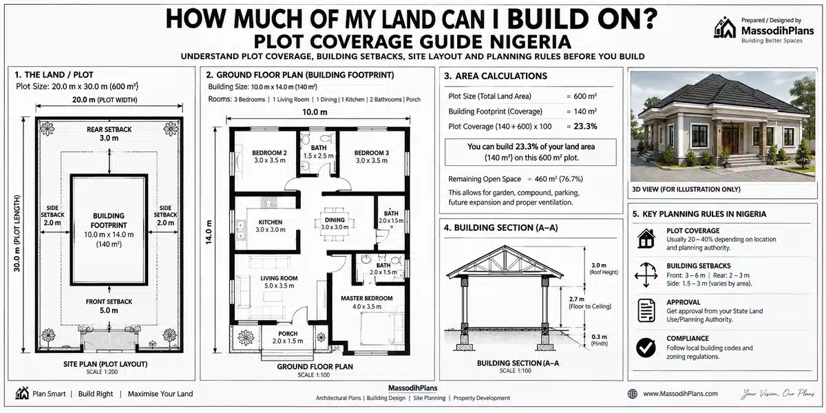
How Much of My Land Can I Build On? Plot Coverage Guide Nigeria
Last month, a client sent me a voice note at almost midnight. He’d just bought a 400 square metre plot in Uyo, already had a beautiful 5-bedroom duplex design he found online, and his question was simple: “Massodih, I don fit build this design on my land?” I asked him one question back “Do you know your plot’s coverage limit?” and there was a long pause. He didn’t even know that number existed.
That pause is why I’m writing this. Almost everybody who buys land assumes the land is 100% theirs to cover with building, the way it’s 100% theirs on paper. It isn’t, and the gap between what people assume and what’s actually allowed is where plans get rejected, money gets wasted on redesigns, and honestly where some of the saddest conversations I have with clients happen. So let’s sort this out properly, the way I would if you were sitting across from me with your survey plan on the table.
The Real Question Behind “How Much Can I Build?”
Here’s the first thing to understand, and it changes how you’ll read everything else in this article: “how much of my land can I build on” isn’t actually one number. It’s at least three separate numbers, each controlling a different thing how much ground your building covers, how much total floor space you can have across all your floors, and how dense your development is allowed to be compared to your neighbours’. Confuse these three, and you’ll either under-build your plot (wasting money you didn’t need to waste) or design something your local planning authority will reject outright.
So before we get into Nigerian specifics or global comparisons, let’s separate these three ideas cleanly, because that separation alone will put you ahead of most people asking this question.
Plot Coverage (Site Coverage): How Much Ground Your Building Can Touch
Plot coverage also called site coverage or building coverage ratio is the percentage of your total land area that your building’s footprint is allowed to occupy at ground level. This is the number that answers the literal question “how much of my land can I build on,” measured flat on the ground, floor by floor doesn’t matter yet.
The formula is straightforward:
Plot Coverage (%) = Building Footprint Area ÷ Total Plot Area × 100
So if you own a 500 square metre plot and your building footprint (the ground floor outline, including covered verandas and attached garages in most jurisdictions) is 250 square metres, your coverage is 50%.
In Nigeria, coverage rules vary by state and by zone within a state, but there’s a consistent pattern worth understanding. And in most Lagos residential zones, buildings must not cover more than 60% of the plot area. In denser, older layouts like parts of Lagos Island, that figure can run higher because the plots themselves were never designed with generous setbacks in mind, while in newer, lower-density residential layouts, coverage limits of 40–50% are common specifically to preserve space for parking, landscaping, and stormwater drainage. Nigeriabuildingcost
Never calculate coverage using your plot’s advertised size alone. Deduct any portion already lost to road widening, drainage easements, or irregular boundary shapes first your “buildable coverage” is often smaller than your paper plot size suggests, and this gap catches small-plot owners more than anyone else.
Here’s where I have to be the friend who tells you the truth instead of the one who just agrees with you: if you’ve ever seen someone build their house wall-to-wall, right up to the fence, with barely a hand’s width of space on the sides that’s not a design, that’s a violation waiting to be discovered. As we like to say back home, if you build your house reach your fence like that, na your fence go become your veranda. I have seen a case where a man’s wall was so close to his boundary that his neighbour’s goat could literally poke its head through the burglary-proofing from the next compound. Everybody laughed, but LASPPPA wasn’t laughing when the demolition notice came.
Floor Area Ratio (FAR): How Much Total Floor Space You Can Have
Once you understand coverage, the next number Floor Area Ratio, also called Floor Space Index (FSI) in some countries, plot ratio or site ratio in others answers a different question entirely: not how much ground you can cover, but how much total floor space you can build across every level of your building combined.
Floor Area Ratio = Total Gross Floor Area (all floors added together) ÷ Total Plot Area
Here’s the part that trips almost everyone up: coverage and FAR are not the same number, and you need both to understand what you can actually build. A FAR of 1.0 on a 500 square metre plot means you can build 500 square metres of total floor area but how that 500 square metres is arranged depends on your coverage limit. If your coverage limit is 50%, that 500 square metres of allowed floor area has to be spread across two floors (250 sqm each), not built as one giant single-storey sprawl covering the whole plot.
This is genuinely useful information, so let me be clear with a joke here because I know some of you are already confusing yourselves: FAR is not “how many floors” if someone tells you your FAR is 1.5, that does not mean you should go and build one-and-a-half storeys, with the top floor stopping halfway with somebody’s head still sticking out the roof like a half-finished Lego house. FAR is a ratio of total space, not a floor count you and your architect decide how to arrange that total allowed floor area across however many storeys make sense for your design and your coverage limit.
If your FAR allowance feels generous but your coverage limit is tight, that’s actually good news it’s telling you to build upward (more floors on a smaller footprint) rather than outward, which also tends to leave you more usable outdoor space. This is one of the most underused strategies on small Nigerian plots.
Building Density: Why Your Neighbourhood’s Rules Aren’t the Same as the Next One
Building density is the broader zoning concept that coverage and FAR both serve. It describes how intensively a given area is permitted to be developed how many dwelling units per hectare, how tall buildings can go, how close together they can sit and it’s set at the neighbourhood or zone level, not per individual plot.
This is why the same size of land in two different parts of the same city can have completely different rules. A 500 square metre plot in a designated low-density residential zone (think many parts of GRA layouts, or low-density estates) might be capped at 40% coverage, two storeys, and generous setbacks, specifically to preserve an open, spacious character. The identical 500 square metre plot in a high-density zone or inner-city layout might be permitted 60-70% coverage and four storeys, because that zone was planned for more intensive use from the start.
Density zoning exists for real, practical reasons road capacity, drainage capacity, water and power infrastructure were all sized around an assumed density when the area was planned. This is exactly why “but my neighbour built four floors” is not a valid argument when your plot sits in a zone capped at two your neighbour may have gotten away with a violation, may be in a different zone than you think, or may have a variance you don’t know about. Always confirm your own plot’s zone classification directly, never infer it from what’s already standing next door.
How Much Land Should Remain Open — And Why It’s Not Wasted Space
This is the question I think gets the least honest answer anywhere online, because people treat the “open” portion of their plot as leftover space rather than functional space. It isn’t leftover. Every square metre your coverage limit forces you to leave open is doing real work:
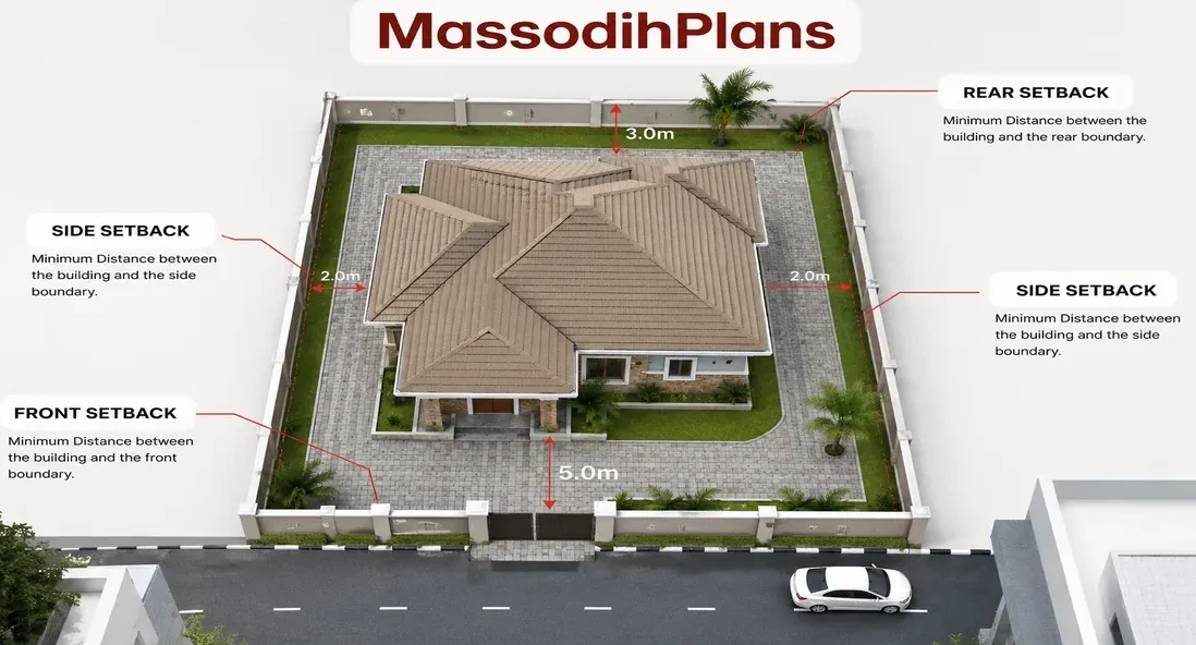
Setbacks the mandatory distance between your building and your plot boundary protect your neighbour’s privacy and yours, allow light and air circulation between buildings, and in many Nigerian jurisdictions, specifically reserve space for soft landscaping. In Lagos, for example, the standard residential front setback explicitly includes a 900mm strip meant for greenery, meaning you legally cannot pave or build right up to that line even within your own setback allowance.
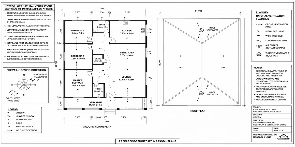
Drainage and stormwater management open, permeable ground absorbs rainfall that paved or built-over ground simply sheds onto the street or your neighbour’s plot. This is not a minor detail in Nigeria’s rainy season.
Parking
Parking open compound space is usually where your actual parking requirement gets satisfied, and planning authorities check this during approval.
Future flexibility open space you don’t use today (a side extension, a future garden shed, solar panel ground-mounts) is space you’ll be glad you preserved later.
And this brings me to my third and final joke, because I have watched this mistake happen too many times to count: some people get their coverage limit, see “open space,” and decide the smartest thing to do is pave the entire open portion with interlocking stones because “at least it will look clean.” Then the first heavy rain comes, and because there’s now nowhere for water to soak into the ground, the water does what water does it finds the lowest point, which is usually your own doorstep. Na so some people go turn their sitting room to swimming pool, all because dem no want see one blade of grass for compound. Leave the open space genuinely open. Interlocking is fine; leave some of it as real, permeable ground too.
Check whether your local planning authority or your estate’s covenants specify a minimum percentage of “soft landscaping” or permeable surface, separate from your coverage limit. Many people satisfy coverage but still fail approval because they paved over areas that were meant to stay permeable.
Maximum Development Density: Putting the Whole Picture Together
Now that coverage, FAR, and density zoning each make sense on their own, here’s how they work together to answer the original question completely. Your maximum development density for a specific plot is really the combined result of:
- Your plot’s zone classification (set by your city/state’s planning framework)
- The maximum coverage percentage permitted for that zone
- The maximum FAR (total floor area allowance) permitted for that zone
- Height restrictions, which interact with both of the above a height cap can prevent you from using your full FAR allowance even if coverage would technically allow more floors
- Mandatory setbacks, which determine your actual buildable footprint shape, not just its size
Get any one of these wrong, and your design will either be rejected at approval stage or worse approved on paper but impossible to build once your architect lays out the real geometry of setbacks against your plot’s actual shape, which is especially punishing on irregular or narrow small plots.
A Simple 4-Step Framework to Find Your Own Plot’s Buildable Limit
This is the part I wish someone had handed my midnight-voice-note client before he fell in love with a design. Do this before you commission or approve any drawing:
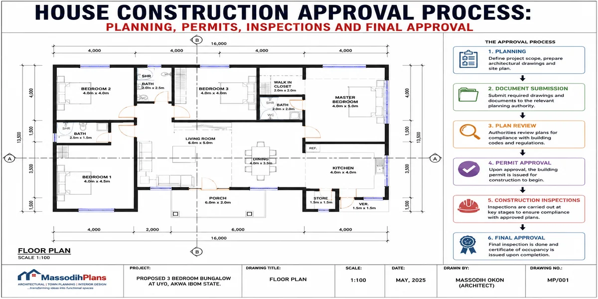
Step 1: Get your zone classification. Visit or contact your state/local planning authority (in Nigeria, this is typically your state’s physical planning board or urban development authority) and ask directly: “What is the zone classification for this plot, and what are the development control standards for that zone?”
Step 2: Get the three numbers for your zone. Ask specifically for the maximum coverage percentage, the maximum FAR, and the mandatory setback distances for your zone don’t accept a vague “it depends,” insist on actual figures for your specific zone classification.
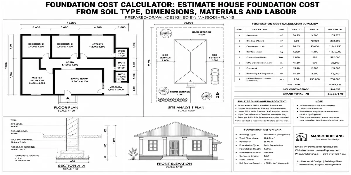
Step 3: Calculate your real buildable footprint. Take your plot’s actual area, subtract any easements or irregular boundary losses, apply your setback distances to see what shape and size footprint physically remains, then check that footprint against your coverage percentage. The smaller of the two what coverage allows, or what setbacks physically leave you is your real limit.
Step 4: Check your FAR against your intended floor count. Multiply your real buildable footprint by however many floors you’re planning, and confirm the resulting total floor area doesn’t exceed your FAR allowance. If it does, you need either fewer floors, a smaller footprint, or a design that uses vertical space more efficiently.
Do this calculation before you fall in love with any specific design, not after. It costs nothing but a phone call and ten minutes of arithmetic, and it will save you from commissioning drawings for a house your plot cannot legally hold.
A Worked Example: A Small 450 Square Metre Plot
Since small plots are exactly what this is about, let’s actually run the numbers, the way I would with a client.
Say you own a 450 square metre plot, zoned standard residential, with a coverage limit of 50%, a FAR of 1.0, and mandatory setbacks of 6 metres front and 3 metres on the sides and rear.
- Maximum ground coverage allowed: 450 × 0.50 = 225 square metres
- Maximum total floor area allowed (all floors combined): 450 × 1.0 = 450 square metres
Now check this against your setbacks. On a typical rectangular 15m x 30m plot, a 6m front setback and 3m rear setback removes 9 of your 30 metres of depth, and 3m on each side removes 6 of your 15 metres of width — leaving a buildable rectangle of roughly 9m x 21m, or about 189 square metres. That’s below your 225 square metre coverage allowance, which means in this case, your setbacks not your coverage percentage are the real constraint on your footprint.
With a 189 square metre ground floor footprint and a 450 square metre FAR allowance, you could comfortably build a two-storey home (189 + 189 = 378 sqm, still under your 450 sqm FAR cap) with room to spare for a partial third level or an extension later all while staying fully compliant. This is exactly the kind of math that should happen before, not after, a design is commissioned.
Global Snapshot: How These Rules Differ Around the World
If you’re reading this from outside Nigeria and a good number of this platform’s readers are planning diaspora builds or simply curious how this compares to where they currently live it’s worth knowing that the underlying concepts (coverage, FAR, density) are close to universal, even though the specific numbers and even the terminology shift by country and, often, by municipality within the same country.
United States coverage and FAR are both common, but regulated at the municipal/zoning-code level, so the exact figures vary enormously between cities and even between neighbourhoods in the same city; always check your specific municipal zoning code.
United Kingdom the equivalent concept is often discussed as “plot ratio” or site coverage within local planning authority development plans, alongside separate “garden grabbing” and back-garden development restrictions in many residential areas.
Germany density is regulated through the Bebauungsplan (local development plan), which specifies Grundflächenzahl (site coverage ratio) and Geschossflächenzahl (floor area ratio) for each designated zone.
UAE coverage and FAR limits are set per emirate and per specific zoning authority (such as Dubai Municipality or Abu Dhabi’s Department of Municipalities and Transport), and vary significantly between villa communities and denser urban plots.
Switzerland cantonal and municipal zoning plans (Nutzungsplanung) specify both coverage (“Ausnützungsziffer”/utilization ratio) and building envelope rules, often with strict controls to preserve neighbourhood character.
Others
Canada and Australia both use lot coverage and floor space ratio extensively in municipal zoning bylaws, with Australia also commonly referring to “floor space ratio (FSR)” in state planning instruments.
Singapore one of the most precisely regulated examples globally, where Gross Plot Ratio (GPR) is specified down to the individual plot through the Urban Redevelopment Authority’s master plan.
Luxembourg, Iceland, and Qatar all apply similar coverage and density principles through municipal or national planning frameworks, though public documentation of exact figures is less consolidated online than in larger markets, making a direct conversation with the local planning authority the reliable path in these jurisdictions.
The universal lesson, wherever you’re building: the specific percentages change by country and even by street, but the three underlying questions how much ground, how much total floor space, how dense overall never do. If you’re building in Nigeria while living abroad, don’t assume your host country’s density norms (which may be far more permissive or far stricter) apply back home; always get Nigerian-specific figures confirmed locally before finalizing any design.
Common Myths and Mistakes About Plot Coverage
“It’s my land, I can build on all of it.” No jurisdiction I’m aware of permits 100% coverage on a standard residential plot coverage limits exist precisely to preserve light, drainage, and safety access between buildings.
“My neighbour built bigger, so I can too.” Your neighbour’s building may violate the rules without having been caught yet, may sit in a different zone than you assume, or may hold an approved variance you’re not aware of never use a neighbouring building as your reference point.
“FAR and coverage are the same thing.” They’re not coverage controls your footprint on one floor; FAR controls your total floor area across every floor combined. You need both numbers, not one.
“If I leave the required setback, I’ve automatically satisfied coverage.” Not necessarily on an irregularly shaped or very small plot, your setback-constrained footprint can end up smaller than your coverage percentage would technically allow, meaning setbacks become your real limiting factor, as in the worked example above.
“Open space is wasted space, so I should pave or build on all of it.” Open space does real work drainage, parking, light, and air and paving over all of it tends to create the flooding and ventilation problems people later blame on “poor city planning” generally.
Quick Reference Cheat Sheet
| Term | What It Measures | Formula | Controls |
|---|---|---|---|
| Plot/Site Coverage | Ground-floor footprint vs. total plot | Footprint ÷ Plot Area × 100 | How much ground your building touches |
| Floor Area Ratio (FAR/FSI) | Total floor area across all floors vs. plot | Total Floor Area ÷ Plot Area | How much total space you can build, any number of floors |
| Building Density | Overall intensity of development permitted in a zone | Set by zoning classification, not a single formula | Combines coverage, FAR, height, and setbacks for an area |
| Setback | Mandatory gap between building and boundary | Fixed distance per zone/frontage type | Shapes your real buildable footprint |
| Open Space Requirement | Minimum land that must stay permeable/landscaped | Often a separate % from coverage | Drainage, parking, light, future flexibility |
Frequently Asked Questions
What percentage of my land can I legally build on in Nigeria?
It depends on your specific zone classification, but residential coverage limits commonly range from 40% to 60% of the plot area, with denser, older layouts sometimes permitted higher figures. Always confirm the exact figure for your specific zone with your state’s planning authority.
What is the difference between plot coverage and floor area ratio?
Plot coverage measures your building’s ground-floor footprint against your total plot size. Floor area ratio measures your total floor space across every level combined against your plot size. A building can comply with one and still violate the other.
Can I build 100% of my plot if it’s a small plot?
No. Coverage limits apply regardless of plot size, and in fact, small plots often face the same absolute setback distances as larger plots, meaning the percentage of usable footprint can be proportionally tighter on a small plot than a large one.
How much open space must I leave on my land?
This is usually determined by the combination of your mandatory setbacks and any separate landscaping or permeable-surface requirement specific to your zone not a single universal percentage, so it needs to be confirmed per plot.
What is maximum development density, and how is it different from coverage?
Maximum development density is the overall combination of coverage, FAR, height limits, and setbacks permitted in a given zone. Coverage and FAR are both components of density, not separate, unrelated concepts.
Does building density affect my resale value?
Often, yes a building that fully and legally uses its permitted density tends to hold value better than an under-built plot with unused potential, but a building that violates its density limits carries real legal and resale risk once discovered.
Finally,
“How much of my land can I build on” is really three honest questions wearing one trench coat how much ground, how much total floor space, and how dense overall and every single one of them should be answered before you fall in love with a design, not after. Do the four-step check above, run the real numbers against your actual plot shape, and you’ll walk into your planning authority’s office with facts instead of hope.
If you’re still at the planning stage, browse our Plans Library for house designs already sized and shaped to work within common Nigerian small-plot coverage and setback limits, or visit Plan School to learn how to read your zoning classification and development control standards before you commission a design. For direct support confirming your specific plot’s buildable limits and turning that into an approvable design, our Services page outlines how we work with clients from first measurement to final approval. You can also explore more building approval and small-plot design guides on our Homepage.
- What Setbacks Do I Need? Small Plot Setback Rules in Nigeria Explained
- How Long Does Planning Approval Take? Nigeria Approval Timelines Guide
- How Much Does Planning Permission Cost? Nigeria Fees & Approval Guide
- Why Was My Planning Application Rejected? Reasons and How to Fix It
- How Do I Do GIS Analysis for My Thesis? A Real Step-by-Step Guide
Author
Massodih Okon is a Nigerian built-environment professional with academic and professional experience in urban and regional planning, geography, architectural design, Landscape Design, GIS and land development.
He holds a Master’s degree in Urban and Regional Planning from the University of Uyo and a first degree in Geography and Regional Planning.
Through MassodihPlans, he publishes practical guides on Nigerian house plans, building design, physical planning, site planning, development approval and residential construction. Read the full author profile →