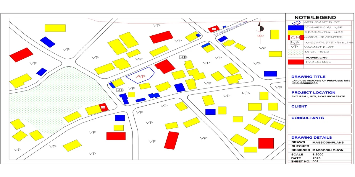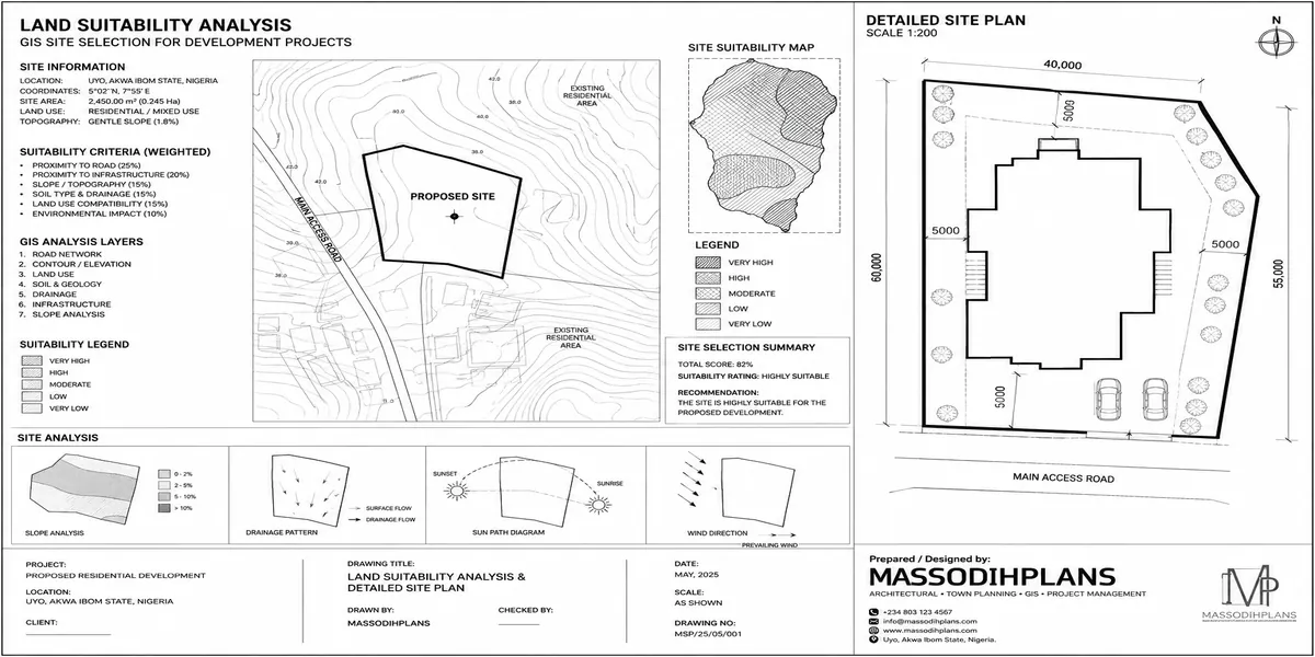
Land Suitability Analysis and GIS Site Selection for Development Projects
A few years back, I sat in a meeting where a client had already bought land paid in full, survey plan in hand, genuinely excited and asked me to “just confirm it’s good for the estate we’re planning.” It wasn’t. The slope was fine. The location was fine. But the site sat inside a natural drainage corridor that three other GIS layers would have flagged in an afternoon, before a single naira was spent. That meeting is the reason this article exists. Not because land suitability analysis is a trending keyword, but because skipping it, or doing it badly, is one of the most expensive mistakes a developer, planner, or student can make and almost nothing written on this topic actually walks through the process the way a practitioner does it on a real project.
So let’s do that here. Not theory for its own sake the actual sequence, the actual criteria, and the judgment calls that separate a suitability map that looks impressive from one that actually protects a client’s money.
What Land Suitability Analysis Is Actually For
Strip away the GIS jargon and the goal is simple: figure out, systematically and defensibly, which parts of a landscape are appropriate for a specific use, and which aren’t before anyone commits money, time, or reputation to a site.
The “systematically and defensibly” part matters more than people realize. Anyone can look at a map and have an opinion about where a housing estate should go. Land suitability analysis exists because opinions don’t hold up in court, in an environmental impact review, or in front of an investor asking why a project stalled two years in when the flood pattern was always visible in the data. GIS gives you a repeatable, evidence-based process instead of a gut feeling dressed up in a nice-looking map.
This matters whether you’re siting a housing estate, a hospital, a landfill, a solar farm, a school, or an industrial park the process is the same even though the criteria and weights change completely depending on what you’re building.
The Complete Suitability Process, Step by Step
Here is the actual sequence I follow, and the one that shows up consistently in serious GIS-based suitability work. Skipping steps, or doing them out of order, is where most weak suitability studies fall apart.
Step 1: Define the Development Objective
Before touching a single dataset, you need brutal clarity on what you’re actually siting. “A good location for development” is not an objective it’s a vague wish. “A site for a 500-unit medium-density residential estate with municipal water and sewer connection within five years” is an objective. The objective determines every criterion you’ll choose afterward. A landfill site and a residential estate can sit on the exact same landscape and want almost opposite things from slope, drainage, and settlement proximity.
Write your objective down as a single sentence before opening any GIS software. If you can’t state it in one sentence, you’re not ready to select criteria yet you’re still deciding what you’re actually building.
Step 2: Identify Criteria
Once the objective is locked, you list every physical, environmental, accessibility, and regulatory factor that genuinely affects that objective. This is where a lot of studies go wrong in one of two directions either they grab a generic criteria list off a template and apply it blindly, or they cram in every dataset they can access whether or not it’s actually relevant to the decision. Good criteria selection is deliberate and objective-specific, not exhaustive for its own sake. We’ll go through the full criteria list in detail below.
Step 3: Collect Spatial Datasets
For each criterion, you need an actual spatial dataset a Digital Elevation Model for slope and elevation, soil survey data, hydrology layers, land cover classification, road and settlement layers, and so on. Data quality and resolution matter enormously here. A 90-metre resolution elevation dataset gives you a very different picture than a 12-metre one, and using the wrong resolution for the scale of your project is a quiet source of bad decisions later in the process.
Step 4: Standardize Datasets
Here’s a problem beginners run into constantly: your datasets don’t speak the same language. Slope is measured in degrees or percent, distance to roads is in metres, soil quality might be a categorical rating, and flood susceptibility might be a probability. You cannot combine these directly. Standardization reclassifies every criterion onto a common scale typically 1 to 5 or 1 to 9 so that a slope value and a distance value both express the same thing: “how suitable is this specific value for my objective,” on the same numeric scale.
Step 5: Assign Weights
Not every criterion matters equally. Slope might be far more decisive for a hillside housing project than distance to a river, while the opposite is true for an irrigation-dependent agricultural project. Weighting is the step where you formally decide relative importance often using a structured method like the Analytic Hierarchy Process (AHP), which uses pairwise comparisons (is criterion A more important than B, and by how much?) to derive mathematically consistent weights rather than arbitrary percentages pulled out of the air.
Step 6: Overlay Criteria
This is the computational heart of the process combining every standardized, weighted layer into a single composite surface using weighted overlay analysis. Each location on the map ends up with a composite suitability score that reflects the combined, weighted influence of every criterion at that exact spot.
Step 7: Produce the Suitability Map
The composite score surface gets classified into suitability categories and this is where most published guides stop short, producing a flat “suitable vs. not suitable” binary that throws away most of the analytical value of the work. We’ll fix that in the next major section.
Step 8: Validate Results
A suitability map is a hypothesis until you check it against reality. Validation means comparing your model’s output against known ground truth existing successful developments, documented flood events, known problem sites and checking whether the model’s predictions actually line up with what you already know happened on the ground. If your model calls a site “highly suitable” that has flooded three times in living memory, the model has a problem, not the site.
Step 9: Interpret Constraints
Beyond suitability scores, every study needs a separate layer of hard constraints legally protected areas, absolute no-build zones, land already committed to another use. These aren’t “low suitability,” they’re exclusions, and conflating the two is a common and dangerous modelling error. A wetland scoring “2 out of 5” on a suitability scale sounds marginal; a wetland that’s legally protected is not marginal, it’s off the table entirely, regardless of what its composite score says.
Step 10: Recommend Development Zones
The final output isn’t a map it’s a recommendation. Which specific zones should be prioritized, in what sequence, with what caveats, and what additional site-specific investigation (soil testing, geotechnical survey, community consultation) should happen before any zone moves from “suitable on the map” to “approved for development.” A suitability study that ends at the map, without this translation into an actual recommendation, has done the analysis and skipped the actual point of doing it.
The Real Criteria, and When Each One Actually Matters
Here’s the list, but more usefully, here’s when each one carries real weight versus when it’s a minor consideration because that judgment is what separates a thoughtful study from a checklist exercise.
Slope
Critical for almost any built development. Steep slopes increase construction cost, erosion risk, and drainage complexity. Generally, slopes under 5% are considered ideal for most building types, 5-15% workable with additional engineering, and above 15% increasingly restrictive and expensive.
Elevation
Matters most in flood-prone or coastal contexts, where low-lying elevation directly correlates with inundation risk, and in mountainous regions where elevation affects accessibility and climate.
Soil
Decisive for foundation design and cost, and for agricultural suitability studies, it’s often the single most heavily weighted criterion of all. Bearing capacity, drainage characteristics, and shrink-swell potential all matter for built development; fertility and texture matter for agriculture.
Geology
Underlying rock and fault conditions affect foundation depth, seismic risk, and groundwater availability. Often underweighted in smaller studies simply because geological data is harder to source at fine resolution.
Drainage
How water moves across and off the site. Poor natural drainage is one of the most common causes of post-construction regret, because its consequences (flooding, foundation damage, mosquito breeding) show up months or years after the suitability study is long forgotten.
Flood susceptibility
Distinct from drainage this looks specifically at historical and modelled flood extent and frequency. In many rapidly developing regions, this is the single most consequential criterion that gets skipped or under-weighted, usually because good historical flood data is harder to obtain than a slope map.
Water proximity
Distance to rivers, lakes, or coastline. Cuts both ways depending on objective: valuable for tourism, agriculture, or certain industrial uses; a genuine risk factor for residential development if too close, given flood and erosion exposure.
Road accessibility
Distance to existing road networks affects construction cost (getting materials in), ongoing accessibility, and land value. Almost universally weighted heavily for any development objective involving people or goods movement.
Distance to settlements
Cuts both ways depending on objective. A residential estate benefits from proximity to existing settlements (shared services, market access); a landfill or heavy industrial site needs distance from them for the opposite reason.
Distance to infrastructure
Power, water supply, telecommunications. A site can be geometrically perfect and still be functionally unsuitable if extending infrastructure to it costs more than the project can bear.
Land use
Current and planned land use classification. A site sitting inside an area zoned for agriculture or conservation is a regulatory constraint, not just a suitability factor.
Environmental sensitivity
Wetlands, critical habitats, biodiversity corridors. This criterion frequently needs to be treated as a hard constraint (an exclusion) rather than a weighted suitability factor, because environmental protection status often isn’t gradable it’s binary.
Population
Population density and distribution, relevant for understanding market demand (residential, commercial) or, conversely, for understanding exposure and displacement risk (industrial, infrastructure projects).
Utilities
Existing water, sewer, and power network coverage, distinct from general infrastructure distance — this is about whether connection is realistically achievable, not just physically close.
Protected areas
National parks, forest reserves, heritage sites, buffer zones around them. Almost always a hard constraint rather than a weighted criterion.
Economic factors
Land cost, market value trends, proximity to economic activity centres. Often the criterion that gets left out of purely physical/environmental GIS studies, yet it frequently determines whether a “highly suitable” site is actually viable to acquire and develop.
Never use a generic, one-size-fits-all criteria list across different project types. A criteria set built for agricultural suitability, applied unmodified to a residential site selection, will systematically misjudge multiple criteria proximity to settlements, for instance, is a positive factor for housing and often a negative one for farmland. The objective you defined in Step 1 must drive which criteria you include and how you weight them.
Recent land-suitability research across multiple contexts consistently converges on the same core criterion set for development site selection elevation, slope, drainage proximity, soil, land cover, settlement density, and flood factors combined through weighted GIS overlay, which is exactly the structure this process follows.
Why “Suitable or Not Suitable” Is a Lazy Answer
Here’s where I want to push back hard on how most published suitability maps present their results. A binary suitable/not-suitable output throws away almost everything useful the analysis produced. Real landscapes don’t split cleanly into two categories, and pretending they do makes the output far less useful for actual decision-making.
Instead, a properly classified suitability map should use five graduated classes, each with a distinct, actionable meaning for development:
Very Suitable
The composite score is high across nearly every weighted criterion. These are your priority zones development here typically proceeds with standard engineering practice and minimal additional mitigation. This is where you recommend a developer look first.
Suitable
Strong overall performance, but with one or two moderate constraints perhaps slightly steeper terrain requiring standard grading, or a moderate distance to existing infrastructure requiring extension. Development here is entirely viable but should budget for the specific constraint identified.
Moderately Suitable
A mixed profile some criteria score well, others score poorly enough to require genuine engineering or design intervention. This is not a “no,” but it is a “proceed with a targeted feasibility study on the specific weak criterion” for example, a moderately suitable site might need a proper geotechnical investigation before foundation design can be finalized.
Marginal
Suitability is achievable only with significant intervention major drainage works, substantial infrastructure extension, extensive earthworks. Development is technically possible but the additional cost and risk need to be weighed explicitly against alternative sites, because marginal sites are where budgets quietly balloon.
Unsuitable
Fundamental, likely uneconomical-to-overcome constraints severe flood exposure, unstable geology, or conflict with a hard regulatory constraint. This is a genuine “look elsewhere,” not a “proceed with caution.”
This five-tier structure is exactly why a suitability study is worth commissioning in the first place it doesn’t just tell a developer yes or no, it tells them where to look first, where a bit more investigation is worth the cost, and where to walk away before spending on land they’ll regret.
When you present suitability results to a client or a board, never lead with the map. Lead with the classification table and what each class means in plain terms for their specific project. The map is the evidence; the classification and its practical translation is the actual decision-support tool.
“A Suitable Site Is Not Necessarily a Buildable Site”
This is the section I most want you to walk away remembering, because it’s the gap between a good GIS analyst and a good development advisor. A site can score “Very Suitable” on every physical criterion in your model and still be a genuinely bad choice to build on because physical suitability is only one of at least seven distinct kinds of suitability a real project needs, and they don’t automatically move together.
Physical suitability
What your GIS overlay directly measures: slope, elevation, soil, drainage, geology. Necessary, but only the starting point.
Environmental suitability
Whether development here avoids unacceptable ecological damage habitat disruption, wetland loss, biodiversity impacT independent of whether the ground itself is physically fine to build on.
Accessibility
Whether people, materials, and services can actually reach the site reliably, not just whether a road exists somewhere near it on a map. A site can be five kilometres from a major road and still be functionally inaccessible if that connecting stretch floods every rainy season.
Infrastructure suitability
Whether power, water, and sewer connections are actually achievable within a reasonable cost and timeframe — physical proximity to infrastructure on a map means little if the utility provider has no near-term plan to extend capacity to that specific area.
Regulatory suitability
Whether current zoning, land use policy, and approval pathways actually permit your intended development on this land, regardless of how physically ideal it is. I have seen physically excellent sites sit undeveloped for years because they were zoned for a use the developer never intended to pursue, and nobody checked before buying.
Economic suitability
Whether land acquisition cost, development cost, and realistic market value actually support a viable return. A physically perfect site at a price that makes the project unprofitable is not, in any meaningful sense, a suitable site for that project.
Development feasibility
The composite judgment across all six of the above, plus practical questions of timeline, ownership complexity, community relations, and financing the honest, whole-picture answer to “should we actually build here,” which is a bigger question than any single GIS layer can answer alone.
A site can be Very Suitable physically and Unsuitable regulatorily. It can be Suitable environmentally and Unsuitable economically. Real development decisions live at the intersection of all seven, and a GIS suitability map however well built is answering the first one or two of these seven questions, not all of them. Treating a physical suitability map as a complete feasibility study is the single most consequential misunderstanding I encounter in this field, and it is exactly how developers end up owning “suitable” land they can’t actually build on.
Validating a Suitability Model Against Reality
Validation deserves more attention than it usually gets, because an unvalidated suitability model is really just an elaborate, well-illustrated guess.
Practical validation approaches include:
Checking your model’s classification against locations with known, documented outcomes existing developments that have performed well or poorly, historical flood extents, past project failures and confirming the model would have correctly classified them
Sensitivity testing deliberately varying your criteria weights within a reasonable range and checking whether your final classification map changes dramatically. If small weight changes flip large areas between suitability classes, your weighting scheme needs more rigor before you trust the output
Ground-truthing a sample of sites the model rates highly and a sample it rates poorly through an actual site visit, not just a desk review
Cross-checking your standardized criteria scales against professional or regulatory thresholds relevant to your sector, rather than arbitrary numeric ranges chosen for mathematical convenience
A model that hasn’t been checked against at least one of these is not ready to inform a real financial decision, no matter how sophisticated the overlay analysis behind it looks.
Interpreting Constraints Correctly
One habit separates careful analysts from careless ones: constraints and low suitability scores are not the same thing, and conflating them produces genuinely dangerous recommendations.
A criterion like “distance to major road” naturally grades on a spectrum closer is generally better, farther is generally worse, and there’s a smooth gradient between them. That’s a suitability factor, correctly handled through weighted scoring.
A criterion like “inside a legally gazetted forest reserve” or “within a mapped flood defense easement” is not a spectrum it’s a binary exclusion. No amount of high performance on other criteria should be allowed to mathematically outweigh a hard legal or safety constraint in your composite score. The correct approach is to mask these areas out entirely before or after the weighted overlay never to let them simply lower the score while remaining theoretically “developable” in the model’s output. Getting this distinction wrong is how technically defensible-looking suitability maps end up recommending zones that were never legally available in the first place.
Recommending Development Zones: Turning the Map Into a Decision
The final step is translating everything above into an actual recommendation a client, board, or planning authority can act on:
Prioritize Very Suitable and Suitable zones first, sequenced by size, land ownership complexity, and proximity to existing infrastructure
Flag Moderately Suitable zones with the specific targeted investigation each one needs before proceeding — don’t leave “needs further study” vague
Treat Marginal zones as genuine cost-benefit decisions requiring explicit comparison against better-scoring alternatives, not default fallback options
Exclude Unsuitable zones and constraint areas clearly, with the specific reason documented physical, environmental, or regulatory so the exclusion can be defended later if challenged
Cross-check every recommended zone against the seven suitability dimensions above physical, environmental, accessibility, infrastructure, regulatory, economic, and overall feasibility before it goes into a final report
A recommendation that stops at “these zones scored highest” has done half the job. A complete recommendation tells the client what to do next, in what order, and what to check before committing money.
Frequently Asked Questions
What software is used for land suitability analysis?
GIS platforms with spatial analysis and weighted overlay capability ArcGIS Pro and QGIS are the two most widely used, with QGIS being a strong free/open-source option for smaller studies or students building their first suitability model.
What is the difference between land suitability analysis and site selection?
Land suitability analysis is the broader technical process of scoring and classifying land based on multiple criteria. Site selection is the applied decision that uses suitability analysis, alongside the other six suitability dimensions covered above, to choose an actual location for a specific project.
How many criteria should a suitability study include?
There’s no fixed number the right count is however many criteria genuinely affect your specific development objective. Including irrelevant criteria dilutes the analysis; excluding a genuinely relevant one produces a flawed recommendation. Quality of criteria selection matters far more than quantity.
Can a site be highly suitable on a GIS map but still fail as a project?
Yes, routinely this is exactly the physical-versus-buildable distinction covered above. Regulatory, economic, or infrastructure suitability can each independently sink a project that scored perfectly on physical suitability alone.
Why use five suitability classes instead of just suitable/unsuitable?
Because real landscapes and real decisions aren’t binary. Five graduated classes tell a developer where to prioritize, where to investigate further, and where the cost-benefit case needs explicit weighing a binary map only tells them yes or no, discarding most of the analysis’s practical value.
Conclusion
Land suitability analysis done properly isn’t a mapping exercise it’s a decision-support process that should save a client from exactly the kind of expensive surprise I opened this article with. The GIS overlay is the engine, but the real value sits in disciplined criteria selection, honest weighting, graduated classification, rigorous validation, and above everything else remembering that a suitable site on a map and a buildable site in reality are two different questions that deserve two different answers.
Land Suitability and GIS Site Selection as a Professional Service
Everything above explains the process. This part explains what it actually looks like when you commission it as a service because I get asked these questions on nearly every project, and they rarely get answered anywhere online in plain terms.
What Problem Does This Service Solve?
At its core, this service exists to stop a client from committing money to land that will fight them later land that floods in a season they never saw, sits on soil that will triple their foundation cost, or falls inside a zoning or protected-area boundary nobody checked before the purchase agreement was signed. It replaces “this land looks fine” with “here is the evidence, across every criterion that matters for what you’re building, showing exactly where this land is strong, where it’s compromised, and what that means for your specific project.” That’s the problem turning a guess into a defensible decision before the money moves.
Who Needs It?
Real estate developers and estate promoters sitting on raw land before laying out plots. Government agencies and municipalities siting public infrastructure schools, hospitals, waste facilities, roads. Private investors, including diaspora clients, buying land remotely without the ability to walk the site themselves. Agricultural investors deciding where crop-specific suitability actually exists rather than assuming any open land will do. Environmental and infrastructure consultants who need a defensible technical basis before a project goes to an approval board or an investor committee. If you’re about to spend meaningful money based on where a building, estate, or facility sits, you’re the audience for this.
When Should You Commission It?
Before you buy the land, not after. This is the single most common timing mistake I encounter clients commission a suitability study once they already own the land, hoping it confirms what they’ve already committed to, rather than commissioning it while they still have the option to walk away or negotiate price down. The right moment is during due diligence, alongside the survey and title search, before funds change hands. If you already own the land, it’s still worth doing but the value shifts from “should we buy this” to “how do we now build on this responsibly, and what does it cost us.”
What Information Do We Need From the Client?
The development objective, stated as specifically as you can manage what you’re building, roughly how much of it, and on what timeline. The site’s location and boundary, ideally as a survey plan or coordinates, not just a general description. Any known site history prior flooding, prior land use, any existing site investigations already done. Your priorities, if you have them is cost more important than speed, is environmental sensitivity a board-level concern, is there a hard budget ceiling on infrastructure extension. The more honestly specific this input is, the more useful and less generic the resulting criteria weighting will be.
The single most useful thing a client can hand over at the start isn’t a dataset it’s an honest answer to “what would make you walk away from this land even if it looks good?” That answer usually reveals which criteria actually deserve the heaviest weight in your specific study.
How the Analysis and Design Is Carried Out
We start by locking down your objective in a single clear sentence, then select criteria specific to that objective rather than a generic checklist. We source the spatial datasets relevant to those criteria elevation, soil, hydrology, land use, infrastructure and settlement layers at a resolution appropriate to your project’s scale. Each dataset gets standardized onto a common suitability scale, weighted through a structured comparison process, and combined through weighted overlay into a composite suitability surface. That surface is classified into the five-tier system covered earlier, checked against known ground conditions for validation, and reviewed specifically for hard constraints that need to be excluded rather than merely scored low. The output is then translated into an actual zone-by-zone recommendation, not just a colored map.
What the Client Receives
A written report explaining the objective, criteria, and weighting logic in plain language, not just GIS jargon. The classified suitability map itself, showing Very Suitable through Unsuitable zones across your site or study area. A constraints layer clearly separating hard exclusions from graded suitability scores. A zone-by-zone recommendation with the specific further investigation each zone needs before construction. And, where relevant, a plain summary of which of the seven suitability dimensions physical, environmental, accessibility, infrastructure, regulatory, economic, feasibility still need dedicated follow-up work beyond this study.
What Decisions the Deliverable Supports
Whether to proceed with a land purchase, walk away, or renegotiate price based on the constraints found. Which portion of a larger tract to prioritize for first-phase development. Whether additional geotechnical, environmental, or regulatory investigation is worth commissioning before design begins. How to sequence a multi-zone master plan so the most suitable land gets developed first. And, for public agencies, a defensible technical basis for siting decisions that will inevitably be questioned by communities, courts, or opposing stakeholders.
Common Mistakes People Make
Commissioning the study after the land is already bought. Using a generic criteria list instead of one built around the actual development objective. Treating a “moderately suitable” score as a soft yes without budgeting for the specific weak criterion behind it. Letting a hard legal constraint a protected area, a drainage easement get buried inside a weighted score instead of excluded outright. Skipping validation entirely and presenting the model’s first output as final.
What Can Go Wrong If the Service Is Skipped?
Land purchased on visual impression alone that turns out to sit inside a flood corridor, on unstable soil, or inside a zoning classification that blocks the intended use. Infrastructure extension costs that weren’t anticipated because proximity was assumed rather than checked. Community or regulatory opposition that a proper environmental and regulatory suitability review would have surfaced early enough to address, rather than after construction had already started. In the worst cases, outright project failure money spent on land, design, and early construction that has to be abandoned or relocated.
Example: A Residential Estate Site in a Coastal-Adjacent Zone
A client came to me with land they intended for a mid-density residential estate, close enough to the coast to be attractive but close enough to raise obvious questions. The physical suitability analysis showed strong slope and soil scores across most of the tract genuinely good news. But overlaying flood susceptibility and drainage proximity data revealed roughly a third of the site sitting inside a seasonal inundation zone that wasn’t visible during a dry-season site visit.
The recommendation wasn’t “don’t build here” it was “build the first two phases on the Very Suitable zone identified, treat the flood-prone third as open space or a stormwater retention feature instead of building plots, and revisit its development potential only if drainage infrastructure upgrades happen at the municipal level later.” That’s the difference between a suitability study and a guess the client kept the land, adjusted the plan, and avoided building homes on ground that floods.
Limitations and Professional Boundaries
A suitability study is not a substitute for a geotechnical investigation, a formal environmental impact assessment, or a legal title search it identifies where those deeper, site-specific investigations are worth commissioning, but it doesn’t replace them. It’s built on the best available spatial data at the time of the study, and data quality limits the precision of the output a study is only as good as the datasets feeding it. It also reflects the objective and priorities defined at the outset; if your development objective changes significantly, the criteria and weights need to be revisited, not assumed to still apply.
Ready to Move Forward?
Here’s what nobody tells you before you pay for a plot: the land is only “good” if it’s good for what you’re building. A site that’s perfect for a warehouse can be the wrong choice entirely for a residential estate. A plot that looks flat and solid to the eye can sit on soil that will triple your foundation cost, or on a flood path that no amount of good architecture will fix later. By the time these problems show up, you’ve usually already paid for the land, started documentation, or worse, broken ground.
This is exactly what a proper Land Suitability Analysis and GIS Site Selection review is built to catch, before you commit a single naira you can’t get back. I map the soil, drainage, zoning, access, and long-term development risk on any site you’re considering, and tell you plainly whether it fits your project or not.
If you are about to buy land, secure a site for a client, or plan a development of any size, do not finalize that decision without this analysis done first. Contact me now through the Services page and let’s assess your site before it becomes an expensive lesson instead of a sound investment.
Related Service/Guides
- 15 Things to Check Around a Plot Before Buying Land in Nigeria Safely Today
- How to Analyse a Property Location Before Buying Land in Nigeria Today
- How Road Access Affects Residential Building and House Planning in Nigeria
- How GIS and Mapping Can Improve Residential Site Planning in Nigeria Today
- How to Read a Satellite Image Before Buying Land in Nigeria: Full Guide
- How GIS Can Help Identify Flood-Prone Areas Before You Build in Nigeria
- GIS, Land Use Change Analysis and Digital Mapping for Planning and Growth
- Site Plan Analysis and Layout Planning for Land Development and Building
- Architectural Design and Drafting for House Plans, Building Plans and 3D
- Site Plan Analysis and Layout Planning for Land Development and Building
- Site Analysis Checklist: 50+ Things to Check Before Building on Your Land
Author
Massodih Okon is a Nigerian built-environment professional with academic and professional experience in urban and regional planning, geography, architectural design, Landscape Design, GIS and land development.
He holds a Master’s degree in Urban and Regional Planning from the University of Uyo and a first degree in Geography and Regional Planning.
Through MassodihPlans, he publishes practical guides on Nigerian house plans, building design, physical planning, site planning, development approval and residential construction. Read the full author profile →