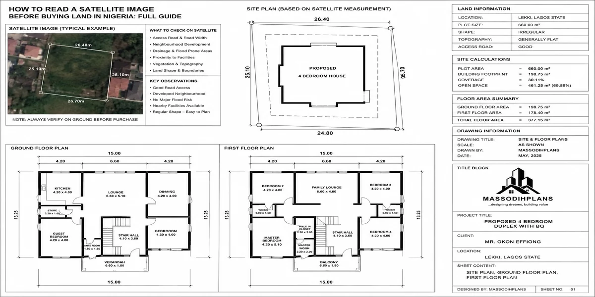
How to Read a Satellite Image Before Buying Land in Nigeria: Full Guide
A client called me two years ago, already excited, already telling family the good news. He had found a plot in a fast-growing part of Rivers State, the agent had a survey plan, the omoniles were “very cooperative,” and the price was good almost suspiciously good, but he didn’t think of it that way at the time. He asked me to just confirm the paperwork looked fine before he paid the balance.
I didn’t start with the paperwork. I opened satellite imagery of the plot first, and within two minutes I could see what the agent’s photos, taken at exactly the right angle, had carefully avoided showing him: the plot sat at the tail end of a natural drainage channel that had been quietly filled and built over by three other houses in the last five years all of which, if you looked closely at the imagery, already showed water-damage staining and one partially collapsed perimeter fence. That land wasn’t cheap because the family was generous. It was cheap because everyone local already knew what happens there every August.
That is the actual point of this guide. Not to teach you GIS theory. To teach you the specific, practical way of looking at a satellite image that would have saved that client several million naira and a year of his life the way I look at land before I ever recommend a client build on it.
Why This Skill Matters More in Nigeria Than Almost Anywhere Else
In countries with mature land registries, most of what a satellite image would tell you is already sitting in a public database flood zones, drainage easements, historical land use, all searchable in minutes. In Nigeria, that documentation gap is exactly where satellite imagery earns its keep, because it shows you the truth of the land regardless of what the paperwork claims or what the seller tells you standing on it.
A survey plan tells you the legal boundary of a plot. It tells you nothing about whether that plot floods every rainy season, whether it sits inside a gazetted government acquisition that’s simply not being enforced yet, whether the “quiet residential area” was farmland eighteen months ago with zero road infrastructure planned, or whether three of your future neighbours have already lost a fence to erosion. Satellite imagery, read properly, tells you all of that for free, before you commit a single naira.
I have GIS training and years of working with layout plans, and I still open imagery on every single site I assess. If it’s useful to me with that background, it’s essential for someone without it.
What You Actually Need (And What You Don’t)
You do not need commercial satellite subscriptions, drone footage, or paid GIS software to do this properly. For assessing a residential or small commercial plot, three free tools cover almost everything:
Google Earth Pro (free desktop application) your main tool, because it has a historical imagery timeline most people don’t know exists
Google Maps satellite view quick current-state confirmation, good for cross-checking Google Earth’s imagery date
Sentinel Hub EO Browser (free, browser-based) useful for a second opinion using different satellite sources when Google’s imagery for a specific area is old or low-resolution
That’s it. Everything below can be done with these three, and two of them cost nothing to download or use.
Google Earth Pro is not the mobile Google Earth app. Download the desktop version specifically the historical imagery slider that makes this whole exercise possible only exists there.
Step One: Find the Plot Precisely, Not Approximately
Everything after this step is worthless if you’re actually looking at the wrong piece of ground, which happens more often than people admit.
Get the coordinates from the survey plan every Nigerian survey plan carries beacon coordinates, usually in UTM or geographic (lat/long) format. If your agent or the family can’t produce these, that alone should slow you down; a plot nobody can pin to exact coordinates is a plot that’s harder to defend later.
Type those coordinates directly into Google Earth Pro’s search bar rather than eyeballing a general area from a landmark description like “near the new filling station.” Landmark-based searches are how people end up assessing the neighbour’s plot instead of their own, then feeling blindsided when the actual land looks nothing like what they checked.
Once you’re on the exact spot, zoom until you can clearly see the plot boundary relative to the surrounding road and adjacent plots you’re establishing a mental map you’ll use for everything else in this guide.
Step Two: Pull Up the Historical Timeline First, Not the Current Image
This is the step almost every generic “satellite imagery” article skips entirely, because most of them are written for people checking their own already-owned property, not for someone deciding whether to buy.
Google Earth Pro has a small clock icon in the toolbar click it, and you get a slider showing every historical image capture available for that location, sometimes going back 15-20 years. This single feature answers questions no seller will ever volunteer:
Was this land ever a swamp, riverbed, or wetland that’s been filled in recently? Filled wetland looks deceptively normal on a current image but shows up clearly as darker, water-retentive ground in older captures.
Has the area actually developed the way the agent claims, or is that “fast-growing residential estate” still mostly bush with three show-houses built for marketing?
Is there a visible pattern of buildings appearing and then partially disappearing a sign of demolition, disputes, or flood damage forcing people out?
How fast is development actually moving? Compare a five-year-old image to today’s if nothing changed in five years, be sceptical of “guaranteed rapid appreciation” pitches.
Drag that slider through every available year before you look at anything else. You are watching the land’s actual history, not the story you were told about it.
If the historical imagery shows the plot or the immediate area was visibly wetland, swamp, or a natural water channel within the last 10-15 years, treat that as a serious flag regardless of how solid the ground looks today or how confidently the seller denies it. Filled wetland settles unevenly for years and frequently reclaims itself in heavy rainy seasons I have watched this happen to buildings that looked perfectly fine for their first two or three years.
Step Three: Read the Land’s Relationship With Water
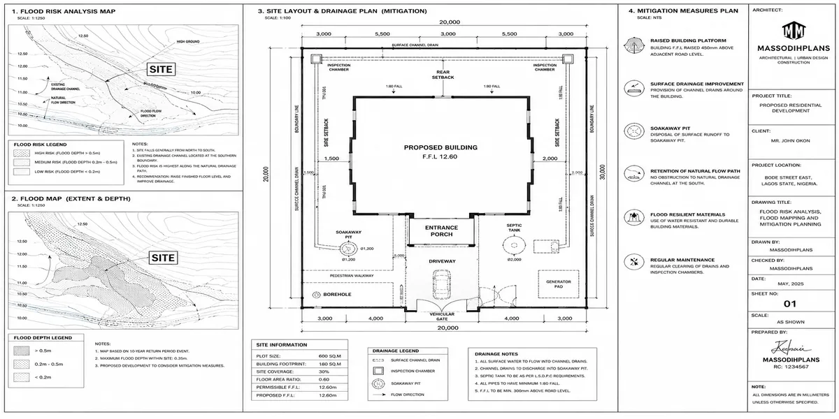
This is the single most financially important thing satellite imagery can tell you before you buy land in Nigeria, because flooding is the risk that destroys the most money, most often, and most silently.
Look for drainage channels and natural water paths
On satellite imagery, these usually appear as darker, curving lines cutting through vegetation or built-up areas sometimes obvious, sometimes disguised by a road built directly over them. Trace any such line near your plot and check where it leads and where it comes from.
Check the plot’s position relative to these channels, not just its distance from them
A plot sitting slightly lower than a nearby channel, even 200-300 metres away, can still flood, because water finds the lowest point across a wide area, not just the nearest one. This is the mistake my client almost made his plot wasn’t beside the channel; it was downhill from where the channel had been filled over.
Look at the colour and texture of neighbouring compounds after recent rainfall, if the image timing allows it
Waterlogged ground often shows as darker, uneven patches, sometimes with standing water clearly visible as flat, uniformly dark or reflective areas. If you can find an image captured during or shortly after rainy season, it is often more revealing than a dozen dry-season images.
Check for visible erosion scarring
Especially relevant in parts of South-South and South-East Nigeria look for jagged, branching pale or exposed-earth patterns cutting into vegetated land, which indicate active gully erosion. This spreads over time, and a plot that looks safely distant from an erosion gully today can be uncomfortably close to it within a few years.
Cross-reference whatever you see with rainfall pattern knowledge for that specific state a channel that looks dry and harmless in a January image can be a raging problem in July. Never let a dry-season image talk you out of a real flood risk.
Step Four: Check What You’re Actually Surrounded By
A plot doesn’t exist in isolation, and satellite imagery is the fastest way to understand what you’re really buying into before you’re emotionally and financially committed.
Identify high-tension power lines
These appear as thin, perfectly straight lines cutting across the landscape, usually with a visible cleared corridor beneath them where vegetation and buildings have been kept clear. Building close to or under one is both a serious safety issue and, in many Nigerian states, a straightforward reason for demolition once enforcement catches up with development.
Look for industrial activity nearby
Even if it’s not obvious from the ground yet a quarry, a large industrial shed, or a waste site shows up on imagery as a distinct cleared, often scarred or discoloured patch that’s easy to miss if you only walk the plot itself and never look beyond its fence.
Check road access honestly, not optimistically. Trace the actual road from your plot back to a known major road. Is it a real, continuous road on the imagery, or does it fade into a footpath or bush track partway? Agents describe roads by intention (“the road is coming”) far more often than by fact.
Look at the density and pattern of surrounding development
A plot surrounded by organized, evenly spaced buildings along a clear road grid tells a very different story from a plot surrounded by scattered, informal structures with no visible road pattern at all the second pattern often signals an area still outside formal planning control, which affects both infrastructure timelines and future approval difficulty.
Step Five: Watch for the Signs of Government-Acquired or Disputed Land
This is where satellite imagery, used alongside basic pattern recognition, can protect you from one of the costliest mistakes in Nigerian land transactions: paying for land the government has already earmarked, or land multiple parties are quietly contesting.
A visibly large, cleared, but consistently undeveloped area sitting within an otherwise actively developing zone
Is worth specific suspicion. Genuinely available, desirable land in a fast-growing area rarely stays completely empty for years while everything around it fills up that pattern often indicates land under some form of government reservation, right-of-way, or unresolved dispute that quietly keeps development away, even where individual sellers insist otherwise.
Fence lines or partial structures that appear, then vanish, then reappear across the historical timeline
Can indicate a genuinely contested plot someone builds, gets stopped, someone else starts, gets stopped, and so on. This pattern is invisible if you only ever see the current image once.
Compare what you see to your survey plan’s stated coordinates and boundary shape carefully
If the shape and position of the visible plot boundary on satellite imagery doesn’t match your survey plan’s dimensions and orientation, that discrepancy needs resolving with a licensed surveyor before you go further this is exactly the kind of quiet coordinate mismatch that sits behind many “flown” or falsified survey plan disputes in Nigeria.
Satellite imagery can raise a red flag, but it cannot confirm land status on its own. Any pattern here that concerns you should be followed up with an actual search at the relevant land registry and survey department imagery tells you where to look harder, not the final legal answer.
Step Six: Match What You See to the Season and Your Own Building Plans
Once you’ve worked through water risk, surroundings, and legal red flags, bring it back to your actual purpose for the land.
If you’re planning to build a duplex needing a deeper or reinforced foundation, cross-check the ground texture and vegetation pattern against what you now know about the site’s water history sandy, well-drained imagery patterns and swampy, dark, poorly-drained patterns call for very different foundation budgets, and knowing this before you buy changes your negotiation position, not just your construction plan.
If you’re buying for a specific use a short-let property, a family home, a small commercial plot check the surrounding development pattern against that use. A quiet, low-density residential pattern today can be a poor fit for a plot you’re hoping will become a busy commercial frontage in five years, and the historical timeline you already pulled up in Step Two tells you whether that kind of change is actually happening around this specific location or not.
The Honest Limits of This Method
I want to be straight with you here, the way I’d be with a client sitting across from me, not the way a generic guide oversells its own advice.
Satellite imagery cannot see underground it will not tell you about soil-bearing capacity, water table depth, or contamination, which still require an actual soil test before construction. It cannot confirm legal ownership or title status only a proper search at the land registry and survey department does that. Free imagery also has a lag; the most recent capture for a specific rural or peri-urban Nigerian location might be six months to two years old, so treat very recent changes (a road just started, a structure just completed) as something to verify on the ground, not assume from an old image.
What satellite imagery gives you is something almost as valuable as a clean title search: an honest, unfiltered view of the land’s real history and real surroundings, unaffected by anyone’s sales pitch. Use it as your first filter, before you spend money on surveys, lawyers, and site visits it will save you from wasting that money on land that was never worth the trouble in the first place.
Frequently Asked Questions
Do I need to pay for satellite imagery to check land before buying in Nigeria?
No. Google Earth Pro and Google Maps satellite view are free and sufficient for assessing water risk, surrounding development, and historical land use for almost any residential plot in Nigeria.
How far back should I check the historical imagery?
As far back as the tool allows, ideally 10-15 years where available. Wetland-fill patterns, erosion progression, and slow-moving disputes are often invisible in anything shorter than that window.
Can satellite imagery replace a physical site visit?
No. It should narrow down which sites are worth a physical visit and tell you specifically what to check on the ground drainage direction, fence conditions, neighbouring structures but it never replaces standing on the actual land yourself.
What’s the biggest single red flag to look for on satellite imagery before buying land in Nigeria?
A visible natural drainage channel or historically wet/swampy ground near or under the plot, even if it’s been filled and looks solid today. This is the pattern behind the largest share of flood-related building disasters I’ve encountered in years of fieldwork.
Can satellite imagery help me confirm if land is government-acquired?
It can raise strong suspicion through patterns like unexplained undeveloped land in an otherwise developing area but confirming actual government acquisition status still requires a direct search at the relevant land registry or ministry.
Conclusion
The land my client almost bought two years ago is still empty today, three years later, exactly as the imagery predicted the family who owns the plot next to it lost half their fence to the same water channel last rainy season. He bought elsewhere, on land I checked the same way, and he’s been in his house for over a year now with no drainage problems to show for it.
That’s really what this skill is for. Not to make you a GIS expert, not to replace your lawyer or your surveyor, but to give you an honest first read on land before anyone’s sales pitch gets a chance to shape what you see. Learn to read the history in the imagery before you fall in love with the story on the ground.
If you’re at the point of assessing a specific plot and want a second, trained set of eyes on the imagery and survey plan together, our Services page outlines how we support clients through exactly this kind of site assessment. Browse our Plans Library if you’re already confident on the land and ready to move to house design, or visit Plan School to understand what comes after site selection in the planning and approval process. You can also explore more land and site guides on our Homepage.
- How GIS Can Help Identify Flood-Prone Areas Before You Build in Nigeria
- How to Analyse Your Plot Using Satellite Imagery Before Building a House
- How to Use Satellite Maps to Study Land Before Buying Property in Nigeria
- How Wind Direction Can Influence House Planning and Natural Ventilation
- How Sun Orientation Affects Residential Building Design in Nigeria Today
- How Nigeria’s Climate Should Influence Your House Design and Site Planning
Author
Massodih Okon is a Nigerian built-environment professional with academic and professional experience in urban and regional planning, geography, architectural design, Landscape Design, GIS and land development.
He holds a Master’s degree in Urban and Regional Planning from the University of Uyo and a first degree in Geography and Regional Planning.
Through MassodihPlans, he publishes practical guides on Nigerian house plans, building design, physical planning, site planning, development approval and residential construction. Read the full author profile →