How Do I Check a Property Before I Build
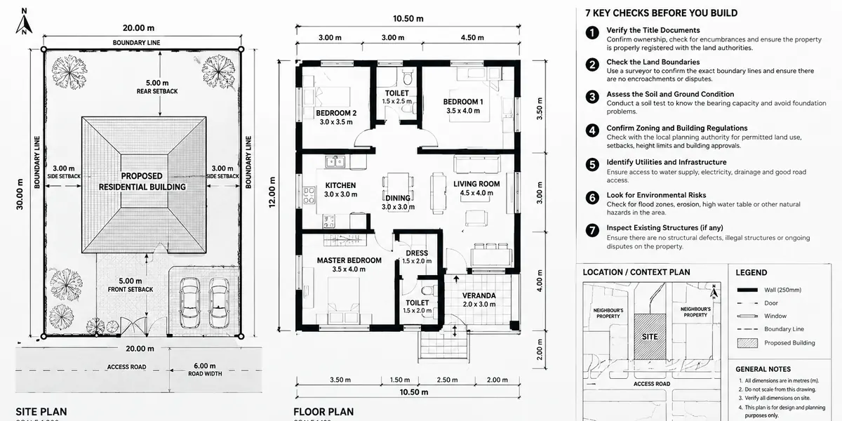
How do I check a property before I build? You can avoid costly building mistakes by carrying out seven essential checks before purchasing land or starting construction: verify the land documents and ownership, confirm the property boundaries and dimensions, check zoning regulations and building approval requirements, measure statutory setbacks and easements, assess soil conditions and drainage, inspect access roads and available utilities, and confirm that your proposed house plan fits the legally buildable area. These checks help you identify hidden restrictions, avoid land disputes, prevent drainage problems, and determine whether the property is suitable for your intended development.
A man called me two years into owning his land, standing beside a drainage channel he had not known existed when he bought it. His fence crossed a statutory easement. He had two options: demolish part of a recently completed wall or challenge the authorities over a problem he could have discovered before signing the purchase agreement. That phone call is the reason this article exists.
I am not offering another generic checklist. I will explain how to inspect a property systematically, using practical measurements, calculations, and the correct order of checks, so you can identify potential problems before committing your money to construction.
This is particularly important when buying a small plot, which is common among the projects we design at MassodihPlans. Every square metre matters. An incorrect setback or overlooked easement on a 450-square-metre plot can significantly reduce the space available for your building. Your preferred house layout may no longer fit, forcing expensive redesigns or compromises.
Whether you are buying land in Nigeria or planning development elsewhere, these seven checks will help you make informed decisions, identify warning signs early, and establish whether the property can accommodate your proposed building before construction begins.
Why “Checking a Property” Is Not the Same as “Inspecting a House”
If you’re buying a finished house, you inspect the structure. If you’re buying land to build on, you’re not inspecting anything that exists yet you’re assessing potential and risk. That’s a completely different exercise, and it’s where most buyers get it wrong. They walk the land, like what they see, confirm the price, and sign. None of that tells you whether you can legally build what you want, whether the ground will support it, or whether water will sit on your foundation every July.
So let’s structure this properly. I check land across ten layers, in this order, because each layer either unlocks or eliminates the next one. There’s no point checking drainage on land you can’t even legally acquire.
Layer 1: Title and Legal Verification
Before anything physical, confirm the land is legally sellable and the person selling it actually has the right to sell it.
What to verify:
- Root of title how the seller acquired it, and from whom, traced back as far as records allow
- Certificate of Occupancy (C of O), or Governor’s Consent where applicable, matching the exact plot described
- Survey plan with coordinates that match the physical boundaries on ground not just a hand-drawn sketch
- Confirmation the land isn’t under government acquisition, committed to a right-of-way, or subject to a pending court case
- Family land: written consent from all recognized principal members, not just the person negotiating with you
A Survey Plan with coordinates is not optional paperwork it is the only document that lets you verify your boundaries with a GPS device independent of what the seller points at on ground. Always get the coordinate values (Beacon/Pillar numbers and their Easting/Northing values), and have a licensed surveyor confirm them against the physical pillars before you pay anything.
For readers outside Nigeria: this layer is universal, just named differently title search and deed verification in the US and UK, Grundbuch (land register) checks in Germany, Dubai Land Department title verification in the UAE, and Torrens title searches in Australia and Canada. The principle doesn’t change: confirm legal ownership and any registered encumbrance before you confirm anything else.
Layer 2: Zoning and Permitted Land Use
Once title is confirmed, the next question is simpler than people expect but gets skipped constantly: is this land even zoned for what you want to build?
Zoning tells you the permitted use (residential, commercial, mixed-use, agricultural), the permitted density, and often the maximum height. Building a 4-bedroom duplex on land zoned for low-density residential is fine. Building it on land zoned agricultural, or in a designated commercial strip, means your approval will be rejected or will require a formal land use conversion first an added cost and delay most buyers never budget for because they never checked.
How to confirm zoning:
Request the zoning classification directly from your state’s Ministry of Physical Planning/Urban Development or the relevant Development Control office
Ask specifically for the permitted density (number of units per plot) and maximum building height for that zone
Confirm whether the land sits inside an approved layout if so, the layout’s own covenants (minimum plot size, architectural style, fencing rules) apply on top of state zoning
This is the layer where small-plot buyers get caught most often. A plot advertised as “residential” might still carry a minimum building setback or minimum plot size requirement from the layout’s approval that makes your intended small-footprint design technically non-compliant without a variance.
Layer 3: Physical Site Verification and Boundaries
Now walk the land, physically, with the survey plan in hand.
- Confirm all four boundary pillars/beacons are present, undisturbed, and match the coordinates on your survey plan
- Check for encroachment a neighbour’s fence, structure, or farming activity extending onto your boundary
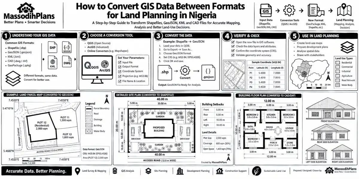
- Confirm the plot shape matches the survey an irregular plot that looks rectangular on paper but is actually trapezoidal on ground changes your usable building footprint significantly, especially on small plots where every metre counts
Boundary discrepancy formula: if your survey states a frontage of F metres but your on-ground measurement gives F′, calculate the discrepancy percentage:
Discrepancy (%) = |F − F′| / F × 100
Anything above 2-3% discrepancy on a small plot is worth raising with your surveyor before you proceed on a 15-metre frontage, a 3% discrepancy is already 45cm, which is the difference between a setback-compliant design and one that isn’t.
Layer 4: Access and Road Frontage
Transitioning from boundaries to access because a plot can have perfect title and zoning and still be a poor investment if you can’t reasonably get into it.
Check:
- Is there a legally dedicated access road, or is access only through an informal path across someone else’s land (a recipe for future dispute)?
- Road width a plot accessed only by a path narrower than 6 metres will struggle to get building materials (block delivery trucks, concrete mixers) onto site, inflating your construction cost through manual haulage
- Road surface and seasonal passability — some access roads in developing layouts become impassable in the rainy season
- Distance from the plot to the nearest tarred/motorable road, which affects both construction logistics cost and future resale value
Visit the access road after a heavy rain at least once before buying, not just on a dry, sunny inspection day. An access road that looks fine in January can be a mud trap in July and that single visit will tell you more about true accessibility than any document.
Layer 5: Orientation and Solar Path
This is where site-checking moves from “can I build” to “will the house I build actually be comfortable” and it’s a layer almost no property-checking article covers, because most are written by estate agents, not designers.
Using a compass or a compass app, determine true north on the plot, then map:
- Which boundary faces north/south (your more forgiving sun exposure) versus east/west (harsh morning and afternoon sun)
- Where the sun rises and sets relative to your intended building footprint, especially important on a small plot where you likely can’t reposition the house far in any direction
Sun angle guidance (Nigeria and similar tropical latitudes, roughly 4°N–14°N): the sun sits close to directly overhead for much of the year, meaning roof overhangs matter more than wall orientation for heat control, but east and west-facing windows still receive the most direct, hard-to-shade solar exposure. Plan your largest window openings toward north and south faces, and keep east/west openings smaller or protected with overhangs, louvres, or vertical fins.
For temperate-climate readers (UK, Germany, Switzerland, Iceland, Luxembourg, Canada): orientation strategy flips in emphasis south-facing glazing becomes a passive heating asset rather than a heat-gain risk, so solar orientation checks on a plot in these climates should assess how much south-facing exposure the site genuinely offers, since that directly affects heating costs for decades.
Layer 6: Setbacks and Buildable Area Calculation
This is the layer that most directly determines how much of a small plot you can actually build on and it deserves real numbers, not vague advice.
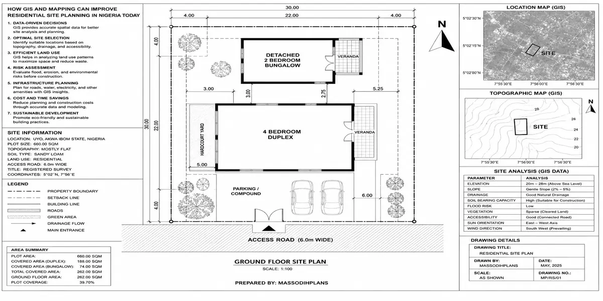
Setback is the minimum distance a building must sit from a plot boundary, usually set by your state’s planning regulations and/or the estate’s layout covenants. Typical Nigerian residential setbacks (always confirm your specific state’s current requirement, as these vary and are revised):
| Boundary | Typical minimum setback |
|---|---|
| Front (road-facing) | 3.0m – 6.0m depending on road classification |
| Rear | 3.0m |
| Sides | 1.5m – 3.0m each |
Buildable area formula:
Buildable Length = Plot Length − (Front Setback + Rear Setback)
Buildable Width = Plot Width − (Side Setback × 2)
Maximum Buildable Area = Buildable Length × Buildable Width
Worked example, for a common small urban plot of 15m x 30m (450 sqm) with a 4.5m front setback, 3m rear setback, and 1.5m setbacks on each side:
Buildable Length = 30 − (4.5 + 3) = 22.5m
Buildable Width = 15 − (1.5 × 2) = 12m
Maximum Buildable Area = 22.5 × 12 = 270 sqm
That’s already a 40% reduction from the raw plot size before you’ve even applied plot coverage ratio (Layer 7) which is exactly why checking setbacks before you fall in love with a floor plan is non-negotiable on small plots.
Layer 7: Plot Coverage Ratio and Floor Area Ratio
Following directly from setbacks, two more figures determine your actual building envelope.
Plot Coverage Ratio (PCR), sometimes called building coverage ratio, limits how much of your buildable area can actually be covered by the ground floor footprint:
PCR (%) = (Ground Floor Footprint Area ÷ Total Plot Area) × 100
Many Nigerian residential zones cap this around 40-50% for low-density areas. On our 450 sqm example plot with a 45% PCR cap:
Maximum Ground Floor Footprint = 450 × 0.45 = 202.5 sqm
Floor Area Ratio (FAR), which some authorities call plot ratio, controls total built floor area across all storeys relative to plot size:
FAR = Total Floor Area (all floors combined) ÷ Total Plot Area
A FAR of 0.8 on a 450 sqm plot permits:
Total Floor Area = 450 × 0.8 = 360 sqm
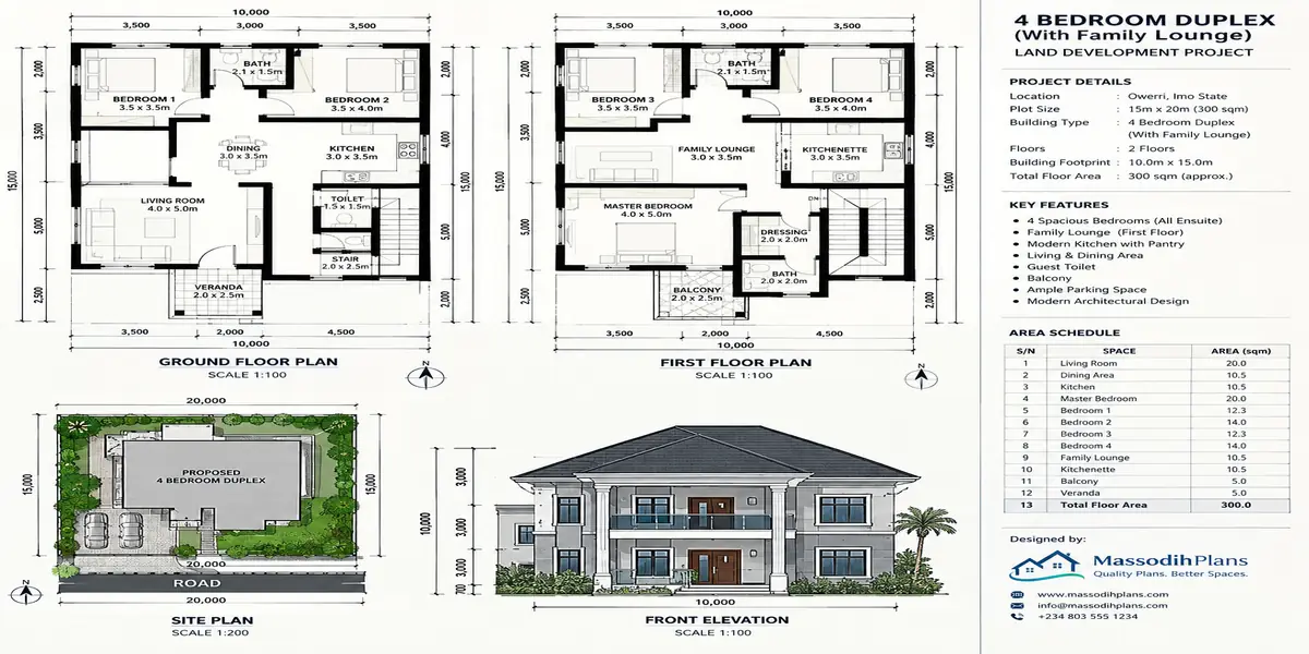
That 360 sqm can be distributed across floors for instance, 180 sqm ground floor and 180 sqm first floor which is precisely why a two-storey design is often the realistic answer for a small plot: it lets you hit your desired floor area within FAR limits without needing a footprint your PCR cap won’t allow.
Request your plot’s specific PCR and FAR figures from the planning authority before commissioning a design, not after. These two numbers alone will tell you, mathematically, whether your dream 5-bedroom layout is even possible on your plot size before you spend money on a design that has to be redone.
Layer 8: Surrounding Land Uses
Shifting focus from your plot to what’s around it, because your neighbours determine your long-term living experience as much as your own design does.
Check what currently exists, and what’s zoned to exist, within roughly a 200-500m radius:
- Industrial or heavy commercial activity nearby (noise, dust, traffic, odour)
- Religious buildings or event centres (noise, parking overflow onto your street)
- Markets or transport parks (traffic congestion, informal commercial encroachment)
- Any planned but unbuilt infrastructure in the master plan a future road widening, a planned drainage channel, or a proposed public facility that could affect your plot later even if it looks empty today
This is also where you confirm statutory wayleave distances if there’s any high-voltage infrastructure nearby:
| Power line type | Typical minimum wayleave/setback |
|---|---|
| Low voltage (distribution, 415V/11kV) | 3.0m horizontal clearance |
| 33kV lines | 6.0m |
| 132kV lines | 15.0m |
| 330kV lines | 30.0m+ |
(Always confirm exact figures with your local electricity distribution company, as these vary by regulator and conductor type.) A plot that looks perfectly buildable can have a chunk of its buildable area eliminated entirely if a transmission line’s wayleave crosses it and this is a layer almost no property listing discloses voluntarily.
Layer 9: Drainage and Flood Risk
This is, in my experience, the single most expensive thing people fail to check and it deserves actual calculation, not just “does it look dry.”
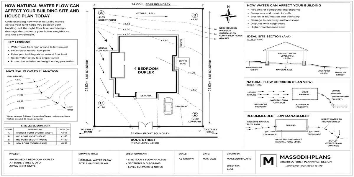
Site gradient and drainage adequacy: land needs a minimum fall to drain surface water effectively. A commonly used minimum gradient for surface drainage is:
Minimum Gradient = 1:100 (a 1% slope a 1cm drop for every 1 metre of distance)
Walk the plot after rainfall, or ask long-standing neighbours, and observe: does water pool and sit, or does it visibly move toward a defined drainage path? Land that holds standing water for more than a few hours after rain, without a clear path for it to leave, needs engineered drainage solutions before you build which adds real cost most buyers never budget for.
Flood risk and freeboard: for land near a river, lagoon, or low-lying drainage channel, check the plot’s elevation relative to the nearest known flood mark or average high-water level. A commonly recommended minimum freeboard (safety margin above expected flood level) is:
Minimum Freeboard = 0.6m – 1.0m above the highest recorded flood level for that specific location
If you can’t get this data locally, ask neighbours how high water has risen in the worst flood they remember, and add your freeboard margin on top of that, not on top of the current dry-season ground level.
Never rely solely on a dry-season site visit to judge drainage. If at all possible, visit during or right after the rainy season before finalizing a purchase this single visit has saved more than one of my clients from buying land that becomes a seasonal pond.
Layer 10: Soil and Environmental Constraints
The ground itself determines your foundation type and cost, and this is worth understanding in approximate numbers even before you commission a formal soil test.
Indicative safe bearing capacity by soil type (always confirm with an actual geotechnical/soil test before finalizing foundation design):
| Soil type | Approximate safe bearing capacity |
|---|---|
| Soft clay / waterlogged soil | 50 – 100 kN/m² |
| Loose sand | 100 – 200 kN/m² |
| Firm/compact sand or laterite | 200 – 300 kN/m² |
| Dense gravel or rock | 300 kN/m²+ |
Lower bearing capacity means you need a wider foundation footing, a raft foundation, or piling to safely spread your building’s load all of which cost significantly more than a standard strip foundation on firm ground. This is exactly why the same 4-bedroom design can cost millions of naira more on one plot than on another just a few streets away.
Other environmental checks at this layer:
- Proximity to a refuse dump, abattoir, or industrial effluent source (odour, groundwater contamination risk)
- Depth to groundwater table, especially relevant if you’re planning a septic system or soakaway, since a high water table reduces how well a septic system can function
- Any history of erosion, subsidence, or ground instability reported for the area
Layer 11: Parking and Vehicular Planning
A smaller layer, but one that quietly affects your buildable footprint and your approval application.
A commonly used residential guideline is roughly one parking space per 2 bedrooms, rounded up, plus one visitor space for homes above a certain size:
Required Parking Spaces = ⌈(Number of Bedrooms ÷ 2)⌉ + 1 (visitor space, where applicable)
For a 4-bedroom home: ⌈4 ÷ 2⌉ + 1 = 3 parking spaces, each typically allowing roughly 2.5m x 5m, meaning your layout needs to reserve a real, usable chunk of ground-floor footprint for this easy to forget when you’re focused on room sizes, and genuinely tight on a small plot once setbacks and PCR have already eaten into your buildable area.
Layer 12: Development Potential and Resale Value
Finally, step back from “can I build” to “should I build here” a question of long-term value, not just immediate feasibility.
Consider: is the area’s infrastructure (roads, drainage, power) likely to improve or decline over the next 5-10 years? Is there visible, credible government or private investment nearby? Is the land in a growth corridor (expanding toward it) or a declining one? A technically buildable plot in a stagnating area is a different investment from a technically identical plot in a growth corridor and this layer is where land purely as shelter and land as investment start to diverge.
Putting It Together: The Site Suitability Score
Here is the scoring system I actually use when walking a site with a client, because a long checklist without a way to weigh the findings against each other just produces anxiety, not a decision.
Score each layer from 0-10 (10 = no concerns, 0 = disqualifying problem), then apply these weights:
Site Suitability Score (SS) = (Legal × 0.25) + (Zoning × 0.15) + (Access × 0.15) + (Drainage/Environmental × 0.20) + (Setback/Coverage Feasibility × 0.15) + (Development Potential × 0.10)
A worked example: Legal = 9, Zoning = 8, Access = 7, Drainage = 6, Setback/Coverage = 8, Development Potential = 7
SS = (9×0.25) + (8×0.15) + (7×0.15) + (6×0.20) + (8×0.15) + (7×0.10)
SS = 2.25 + 1.2 + 1.05 + 1.2 + 1.2 + 0.7 = 8.6 out of 10
As a rough guide: above 8 is a strong buy, 6-8 is buildable with specific precautions you now know to plan for, and below 6 means at least one layer needs serious resolution before you commit money. The real value of this isn’t the final number it’s that scoring forces you to actually investigate every layer instead of skipping the ones that feel like “formalities.”
A Quick Global Layer: How This Differs Abroad
Transitioning to readers checking land outside Nigeria, because the layers above are universal, but the names and mechanisms differ:
United States: zoning verified through the local municipal planning/zoning department; setbacks vary significantly by municipality; flood risk checked via FEMA flood zone maps
United Kingdom: Local Planning Authority confirms permitted use; title checked via HM Land Registry; flood risk via the Environment Agency’s flood maps
Germany: Bebauungsplan (development plan) dictates permitted use, coverage (Grundflächenzahl) and floor ratio (Geschossflächenzahl) directly, often more rigidly specified than in common-law systems
UAE: Dubai Land Department/respective municipality confirms title and permitted use; setbacks and plot ratio set per master development
Switzerland, Luxembourg, Iceland: municipal zoning (commune/Gemeinde level) controls density and setback strictly, often with cantonal or national-level environmental constraints layered on top, particularly around water bodies
Canada, Australia, Singapore: municipal/council zoning bylaws plus title searches (Torrens system in Australia/parts of Canada) function very similarly to the layers above, with local drainage and bushfire/flood overlay checks added depending on region
Qatar: Ministry of Municipality confirms zoning and permitted use; land registration through the relevant real estate registration authority
The formulas for setback, plot coverage, FAR, and parking calculation above apply as a method everywhere only the specific numbers change by jurisdiction, so always pull your local figures from the relevant authority rather than assuming Nigerian figures transfer directly.
Why This Matters More on a Small Plot
Bringing this back to where MassodihPlans actually lives: every layer above compounds more severely on a small plot than a large one. On a 1,000 sqm plot, a 3-metre setback is a minor loss. On a 400-450 sqm plot which is what most of our readers are actually designing for that same 3-metre setback can remove 15-20% of your usable building area, and a missed drainage easement or wayleave restriction can make a design genuinely impossible rather than just smaller. This is exactly why we check every one of these layers before we draw a single wall on a small-plot design, instead of designing first and discovering constraints later.
Frequently Asked Questions
What documents should I request before paying for land?
Survey plan with coordinates, Certificate of Occupancy or evidence of Governor’s Consent, and written confirmation of zoning classification request all three before any payment, not after an initial deposit.
How do I know if land floods without living there a full rainy season?
Ask long-standing neighbours directly what the worst flood they’ve seen looked like, check the plot’s elevation relative to the nearest drainage channel, and where possible, visit during or right after heavy rain before finalizing a purchase.
What is the difference between plot coverage ratio and floor area ratio?
Plot coverage ratio limits how much of the ground your building footprint can occupy. Floor area ratio limits your total floor area across all storeys combined relative to plot size a two-storey design can often achieve a desired floor area within FAR limits where a single-storey footprint cannot fit within coverage limits.
Can I build on land without a Certificate of Occupancy?
It depends on your state’s specific land administration framework and the type of title the land carries (freehold, Governor’s Consent pending, customary title) this needs direct confirmation from the relevant land registry before you proceed, as building without proper title exposes you to serious legal risk.
How much does soil type actually affect building cost?
Significantly. Land requiring a raft or pile foundation due to poor bearing capacity can cost millions of naira more in substructure work alone compared to land with firm soil suitable for a standard strip foundation this is why a soil test before design, not after, is one of the highest-value checks on this entire list.
Finally
Checking a property properly isn’t paranoia it’s the difference between building the home you actually planned and discovering, mid-construction or worse, years later, that something fundamental was wrong with the ground you built on. Walk every layer above in order, get real numbers where numbers exist, and don’t let excitement about a good price skip a single one of them.
If you’re working with a small plot and want these checks folded directly into your design process rather than done separately, our Services page covers how we handle site verification alongside design. Browse our Plans Library for small-plot designs already built around realistic setback and coverage math, or visit Plan School to go deeper into reading survey plans and approval documents. You can also explore more site-planning guides on our Homepage.
- How Do I Compare Two Properties? Size, Value & Land Checks in Nigeria?
- How Do I Produce GIS Maps for My Project? A Practical Mapping Guide
- How Do I Do GIS Analysis for My Dissertation? A Practical GIS Guide
- How Do I Use GIS for My Project? A Practical Guide for Anyone Planning to Build on a Small Plot
- How Do I Determine Service Areas With GIS? Find Coverage Gaps Fast
- Can I Build a Church or Mosque on This Land? Check Nigeria’s Rules
Author
Massodih Okon is a Nigerian built-environment professional with academic and professional experience in urban and regional planning, geography, architectural design, Landscape Design, GIS and land development.
He holds a Master’s degree in Urban and Regional Planning from the University of Uyo and a first degree in Geography and Regional Planning.
Through MassodihPlans, he publishes practical guides on Nigerian house plans, building design, physical planning, site planning, development approval and residential construction. Read the full author profile →