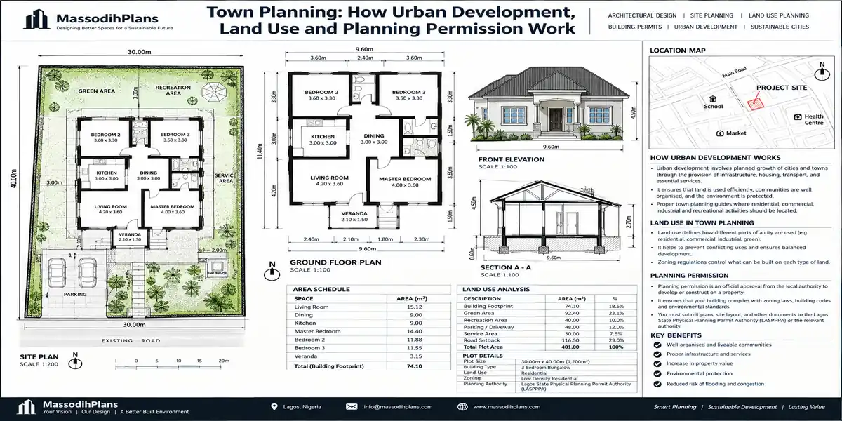
Town Planning: How Urban Development, Land Use and Planning Permission Work
A client called me two years ago, panicking. He’d bought a plot, built his fence, poured his foundation, and gotten a stop-work order pinned to his gate in the same week. He kept asking the same question over and over: “But I have the survey plan, isn’t that enough?”
It isn’t. A survey plan tells you the boundaries of your land. It says nothing about what you’re allowed to build on it, how high, how far from the boundary, or whether the government even considers that land buildable yet. That gap between owning land and having permission to develop it is where most of the confusion in this entire subject lives, and it’s the gap I want to close for you in this article.
I’m writing this as someone who sits on both sides of the table. I’m a registered Town Planner, trained at the University of Uyo in Geography and Urban and Regional Planning, and I’ve spent over fifteen years working across Akwa Ibom and Rivers States reviewing layouts, processing approvals, and yes, occasionally telling clients things they didn’t want to hear about land they’d already paid for. This isn’t a dictionary-definition article. It’s the explanation I’d give you if you sat across from my desk with a genuine problem to solve.
Town Planning, Urban Planning, City Planning, Urban Design: Why Everyone Confuses These
Let’s deal with this first, because almost nobody explains it in a way that actually sticks.
Town planning and urban planning are, in practice, the same profession wearing two different names. “Town planning” is the older, more British-influenced term it’s what the profession is called in Nigeria, the UK, and much of the Commonwealth. “Urban planning” is the term more common in the US and in academic writing globally. If you see a job advert for a “Town Planner” in Lagos and one for an “Urban Planner” in a UN report, they’re describing the same skill set: managing how land is used, how settlements grow, and how development is controlled to keep a place functional and liveable.
City planning
Is usually just urban planning applied specifically at the scale of a city, as opposed to a town, region, or rural settlement. You’ll see it used interchangeably with urban planning in most contexts, though some academic programs use “city planning” to emphasize the metropolitan scale specifically.
Urban design
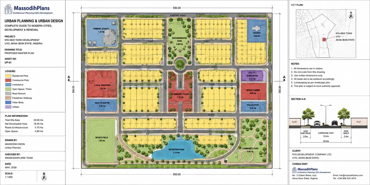
Is where people genuinely start mixing up two different jobs. Urban planning operates at the policy and land-use level deciding that an area is zoned residential, deciding density limits, deciding where infrastructure goes. Urban design operates one level more concrete than that it’s about the physical form: how streets are laid out, how buildings relate to public space, how a neighbourhood actually feels to walk through. A planner decides a district can hold 200 dwelling units per hectare. An urban designer works out what that density should physically look like on the ground street widths, building setbacks, where the green spaces sit. Some professionals do both jobs; many don’t.
“City planning design” isn’t really a separate discipline it’s a search phrase that usually means someone wants to see what good city planning looks like when it’s actually drawn out: the layout, the zoning pattern, the visual result of planning decisions rather than just the policy behind them.
If you remember nothing else from this section, remember this planning decides what’s allowed and where; design decides what it looks like once it’s built. Almost every terminology confusion in this field comes back to mixing those two questions up.
Urban Development and Urban Development Planning: The Bigger Picture
Urban development is the actual process of a settlement growing and changing new roads being cut, new estates rising, informal settlements formalizing, old buildings being replaced. It’s the physical, on-the-ground activity. Planning is the steering wheel; development is the vehicle actually moving.
Urban development planning is the deliberate, forward-looking process of guiding that growth instead of letting it happen randomly. It typically works through a sequence:
- Baseline studies population data, existing land use, infrastructure capacity, environmental conditions
- Projections how much growth is expected, and where the pressure points will be
- Policy formulation what the settlement wants to become, and the rules needed to get there
- Plan preparation the actual master plans, structure plans, and layout schemes that translate policy into a map
- Implementation and monitoring permits, enforcement, and periodic review of whether the plan is actually working
Here’s the part almost nobody says plainly: in most rapidly growing Nigerian cities, development is currently outrunning planning, not the other way around. Buildings go up faster than the infrastructure, zoning enforcement, or drainage systems planned to support them. That mismatch not a shortage of good architects or good intentions is the real root of most of the flooding, traffic, and power strain residents blame on “bad city planning.”
Urban Planner, Town Planner, and Urban Planning Jobs: What This Career Actually Involves
This is a section I rarely see written honestly, probably because most of what’s online is written by people outside the profession describing it from the outside.
What a Town Planner or Urban Planner Actually Does Day to Day
The public image is “someone who draws city maps.” The reality, at least in my experience, is closer to:
- Reviewing development applications against zoning and layout regulations
- Preparing or reviewing Environmental Impact Assessment and Land Use Analysis reports for proposed developments
- Conducting site inspections to confirm a development matches its approved plan
- Preparing master plans, structure plans, and local development frameworks
- Advising government on land allocation, resettlement, and infrastructure sequencing
- Mediating disputes between developers, communities, and regulatory agencies — a part of the job nobody warns you about in school
How to Become a Town Planner or Urban Planner
In Nigeria, the standard path is a degree in Urban and Regional Planning (or a closely related field like Geography with planning specialization), followed by professional registration with the Town Planners Registration Council (TOPREC) and typically membership of the Nigerian Institute of Town Planners (NITP). Internationally, equivalent bodies include the Royal Town Planning Institute (RTPI) in the UK and the American Institute of Certified Planners (AICP) in the US. Registration isn’t a formality in Lagos, for instance, several required planning reports (like the Physical Planning Technical Report) can only be legally prepared and signed off by a TOPREC-registered planner.
Urban Planning Jobs: Where They Actually Exist
Beyond government planning departments, urban planning and town planning graduates work in:
- State and local physical planning boards and development control agencies
- Private urban design and architectural consultancies
- Real estate development and estate layout firms
- GIS and geospatial analysis firms
- International development agencies (UN-Habitat, World Bank urban programs)
- Academic and research institutions
- Environmental consultancy, particularly Environmental Impact Assessment work
If you’re a student reading this trying to decide whether this career is worth pursuing: it’s a field where demand is genuinely growing faster than the number of registered professionals, especially in Nigeria’s fastest-growing cities, precisely because development is currently outpacing the planning capacity to manage it.
Planning Permission and Planning Application: How It Actually Works
This is the section that solves the most real, urgent problems because it’s usually the one people search for only after something has already gone wrong.
What Planning Permission Actually Is
Planning permission is formal government authorization to develop a specific piece of land in a specific way. The process exists, in the words used to describe it by planning authorities, to control the development and use of land and buildings for the best interests of the community not simply as bureaucratic gatekeeping, but as a mechanism to protect drainage, access, safety, and the interests of everyone else who also has to live near what you build.
A planning application is the formal submission you make to request that permission the drawings, reports, and supporting documents you lodge with the relevant authority.
The Process, Step by Step
While the exact names of agencies and documents differ by country and even by Nigerian state, the underlying sequence is remarkably consistent:
Pre-application inquiry confirming the zoning status of the land and what’s permitted on it before you spend money on drawings
Site survey and soil investigation establishing exactly what you’re dealing with
Preparation of drawings and supporting reports architectural drawings, structural drawings, and, depending on the project scale, environmental and traffic impact reports
Submission of the application lodged with the relevant planning authority, usually with an application fee tied to plot size or development value
Validation and review the authority checks the application is complete and assesses it against zoning, setback, density, and safety requirements
Decision approval (sometimes with conditions attached), or refusal with stated reasons
Permit issuance the actual development permit that legally allows construction to begin
Ongoing compliance monitoring inspections during construction to confirm the building matches what was approved
The Nigerian Reality: Two Different Agencies Doing Two Different Jobs
This is the layer almost no article Nigerian or international explains clearly, and it’s the exact confusion that got my client’s site shut down. In Lagos, for example, development control isn’t handled by one agency; it’s split between at least two, and understanding the split matters:
LASPPPA (Lagos State Physical Planning Permit Authority) handles the planning side reviewing your proposed development against zoning and layout rules, and issuing the actual planning permit that authorizes you to build.
LASBCA (Lagos State Building Control Agency) handles a separate function monitoring and enforcing building control compliance during construction, independent of whether LASPPPA already approved your plan.
LASURA (Lagos State Urban Renewal Agency) handles a third function entirely implementing urban renewal policy and slum upgrading, which is a longer-term planning tool rather than a permit-issuing one.
Getting your planning permit from the planning authority does not exempt you from ongoing building control inspections during construction. Many Nigerian self-builders assume that once the permit is granted, the government’s involvement is finished. It isn’t. That misunderstanding is exactly what turns an approved project into a stop-work order later.
Other Nigerian states run a similar structure under different names in Akwa Ibom, for instance, planning and development control sits under the state’s urban and regional planning framework, with area planning authorities handling more localized review. The agency names change from state to state; the underlying two-layer logic planning approval first, building control enforcement throughout does not.
Never treat a planning permit as the finish line. It’s the starting gun. Building control compliance continues throughout construction, and it’s usually checked separately from the agency that granted your original permit.
What to Do If Your Planning Application Is Rejected
This is a genuinely useful, rarely covered piece of practical guidance. A rejection is not the end of the process it’s a checkpoint. Here’s how to actually handle it:
Read the stated reasons carefully. Rejections almost always come with specific grounds setback violations, incomplete documentation, drainage concerns, zoning mismatch. Vague frustration about “the government not wanting me to build” solves nothing; the actual stated reason is what you need to address.
Request a pre-resubmission consultation where the authority allows it many planning offices will informally guide you on what a revised application needs before you resubmit and pay again.
Revise and resubmit rather than build anyway. Building on a rejected application is how stop-work orders and demolition notices happen, and it’s far more expensive to reverse than to simply correct the application first.
Use the formal appeal process where one exists. Some jurisdictions allow appeal to a higher planning authority or tribunal if you believe the rejection was wrongly applied this is a slower but legitimate route for genuine disputes.
Bring in a registered professional if you haven’t already. A large share of avoidable rejections come from applications prepared without a properly qualified planner or architect involved from the start.
Development Planning, Development Control, and Development Management: The Difference That Actually Matters
These three terms get used almost interchangeably online, but in practice they describe three different stages of the same relationship between government and development.
Development planning is the forward-looking, policy-setting stage deciding, before any specific application arrives, what kind of development an area should have: its zoning, density limits, and infrastructure requirements.
Development control is the reactive, gatekeeping stage the actual process of reviewing individual applications against those pre-set policies and deciding whether to approve, condition, or refuse them. This is what most people mean when they talk about “getting government approval.”
Development management is a more recent, broader framing of the same function it includes development control but adds an emphasis on proactive engagement with applicants earlier in the process, monitoring outcomes after approval, and treating the whole relationship as an ongoing management process rather than a single yes/no gate. Some planning systems have formally shifted their language from “development control” to “development management” specifically to signal this more collaborative approach.
For a self-builder, the practical takeaway is simple: development planning already decided your zoning before you bought your land; development control is the specific approval process you’ll go through; development management is the philosophy that should, ideally, mean your planning authority engages with you as a partner in getting it right, not just a gatekeeper waiting to say no.
Land Use Planning and Spatial Planning: Deciding What Goes Where
Land use planning is the process of deciding what activities are permitted on which pieces of land residential, commercial, industrial, agricultural, institutional, or conservation and it’s the foundation everything else in this article sits on. Your plot’s zoning classification, which determines what you’re even allowed to apply to build, comes directly out of a land use plan.
Spatial planning is a broader term, common especially in European planning systems, that goes beyond land use categories to also consider the spatial relationships between activities, infrastructure, and environmental systems across a wider area essentially land use planning plus a stronger integration of transport, environment, and economic development thinking into one coordinated spatial strategy.
For most practical purposes in Nigeria, “land use planning” is the term you’ll encounter directly it’s literally embedded in the name of one of the required planning reports (the Land Use Planning and Analysis Report) that many Nigerian states require before approving significant developments.
Regional Planning and Regional Development: Beyond the City Boundary
Regional planning operates at a scale larger than a single town or city coordinating land use, infrastructure, and economic activity across multiple settlements, local government areas, or even states. It exists because problems like flooding, transportation corridors, and economic specialization rarely respect a single city’s administrative boundary.
Regional development is the broader goal regional planning serves deliberately growing the economic and infrastructural capacity of a wider area, often to reduce over-concentration in one dominant city. Nigeria’s push to develop secondary cities and regional growth poles outside Lagos and Abuja is regional development policy in action, even when it isn’t labelled that way in public discussion.
The practical relevance for an individual landowner is usually indirect but real: a regional plan’s decision to route a highway, designate an industrial corridor, or protect a watershed can dramatically change what your specific plot becomes worth or what you’re eventually permitted to do with it which is exactly why serious land investment research should include regional plans, not just the immediate local layout.
The Master Plan Family: Master Plan, Development Plan, Local Development Plan, and Neighbourhood Plan
This cluster of terms causes more confusion than almost any other in the profession, mostly because the plans are genuinely nested inside each other, and most explanations don’t draw the hierarchy out clearly. Here it is, from widest to narrowest:
Regional plan coordinates land use and infrastructure across multiple settlements or administrative areas
Master plan / urban master plan / city master plan the comprehensive, long-term framework for an entire city or town, covering land use zoning, major infrastructure corridors, and growth direction over a 15-25 year horizon typically
Development plan / local development plan a more localized, often shorter-horizon plan that translates the master plan’s broad zoning into specific policies for a district, ward, or local government area, including the detailed rules a development control officer actually applies to your application
Neighbourhood plan / neighbourhood planning the most localized layer, dealing with a specific residential area or estate’s internal layout, street pattern, plot sizes, and local amenities
Community planning closely related to neighbourhood planning but emphasizes the process itself actively involving residents in shaping decisions about their own area, rather than just the resulting document
A city master plan and an urban master plan are, in essentially all practical usage, the same thing described two different ways “urban” simply signals the broader academic/international term, while “city” specifies the scale directly.
If a client ever asks me “what’s the difference between a master plan and a development plan,” I tell them this: the master plan is the vision for the whole city over decades; the development plan is what that vision means specifically for the piece of land they’re standing on right now. Everything narrower than that neighbourhood plans, community input is filling in the details closest to daily life.
How This Looks Around the World
This nesting structure is close to universal, even though the exact document names differ by country. In the United Kingdom, it runs from the National Planning Policy Framework down through Local Plans to Neighbourhood Plans prepared by parish or town councils. In the United States, it’s typically a Comprehensive Plan (city-wide) implemented through zoning ordinances and, in some cities, neighbourhood-level plans. And in Nigeria, the structure runs from state-level Urban and Regional Planning frameworks down through State Master Plans, Local/District Plans, and estate-level layout schemes reviewed by area planning authorities. In Singapore, it’s the long-range Concept Plan implemented through the more detailed statutory Master Plan reviewed roughly every five years. In Australia and Canada, similar hierarchies exist under names like State Planning Policies and Official Community Plans. The names change; the logic a wide vision narrowing progressively down to your specific plot stays remarkably consistent everywhere planning is taken seriously.
Urban Regeneration: Fixing What’s Already Built
Urban regeneration is the deliberate process of reviving a declining, deteriorated, or underused urban area economically, physically, and socially rather than building on entirely new land. It’s distinct from ordinary urban development precisely because it deals with existing built-up areas carrying existing residents, existing infrastructure problems, and often existing social tensions that a greenfield development never has to navigate.
Common regeneration tools include:
Slum upgrading improving infrastructure, sanitation, and security of tenure in informal settlements without necessarily demolishing them entirely
Adaptive reuse converting old or obsolete buildings to new uses rather than demolishing them
Infrastructure retrofitting upgrading drainage, roads, and utilities in already-built areas to match current population density
Mixed-use redevelopment replacing single-use, deteriorated zones with a deliberate mix of residential, commercial, and public space
Lagos’s urban renewal function, handled through its dedicated urban renewal agency, is a direct institutional example of this a recognition that a growing city needs an ongoing mechanism for fixing what’s already there, not just approving what’s new.
Sustainable Urban Development and Sustainable Urban Planning: Beyond the Buzzword
These terms get used loosely enough that they’ve almost lost meaning in casual use, so it’s worth being specific about what they actually require in practice, not just as an ideal.
Sustainable urban development means growth that meets present needs housing, infrastructure, economic activity without compromising the ability of future residents and the surrounding environment to meet theirs. In concrete planning terms, this generally means:
Environmental sustainability protecting drainage systems, green cover, and water sources from being paved over faster than the city can compensate for the lost natural absorption capacity
Economic sustainability development that generates lasting local economic activity rather than short-term construction booms followed by decline
Social sustainability ensuring growth doesn’t systematically displace or exclude existing lower-income residents without genuine resettlement and compensation
Infrastructural sustainability matching new development density to infrastructure that’s actually sized to support it, rather than assuming roads, drainage, and power will simply catch up later
For most rapidly growing Nigerian cities, the single biggest sustainability gap isn’t a lack of green building materials or solar panels it’s this last point. Development density is frequently approved and built faster than drainage, road, and power infrastructure can be upgraded to match it, which is the direct planning-level cause of the flooding and congestion residents experience, regardless of how individually well-designed the buildings involved are.
Who Actually Does What: A Role Clarity Table
Because this field involves several professionals whose roles genuinely overlap in the public’s mind, here’s the breakdown I actually give clients and students:
Town/Urban Planner sets and applies zoning, density, and land use policy; prepares master and development plans; reviews applications against these policies
Urban Designer translates planning policy into physical form: street layouts, public space design, building massing relationships at neighbourhood scale
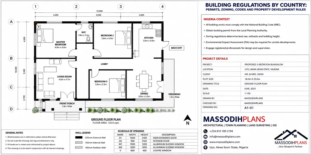
Architect designs the individual building itself within whatever planning and design constraints already apply to the plot
Surveyor establishes the legal boundaries and physical/topographic characteristics of the land itself
Structural Engineer ensures the building’s structure is safe and sound, independent of planning or land use considerations
Civil/Drainage Engineer designs the infrastructure (roads, drainage, water/sewage systems) that supports the development, often working closely with both planners and architects
Most disputes I’ve mediated between clients and government agencies trace back to one of these roles being skipped entirely, or one professional being asked to do a job that legally and technically belongs to another.
Common Myths About Town Planning I Hear Constantly
“If I have a survey plan, I’m covered.” A survey plan establishes boundaries. It says nothing about zoning, permitted use, or approval to build exactly the confusion that opened this article.
“Government approval is just about extracting fees.” Fees fund the review process, but the underlying purpose drainage, safety, access, and protecting neighbouring landowners is real and matters even when the fee structure feels burdensome.
“Once I have my planning permit, government involvement is over.” As covered above, building control monitoring typically continues throughout construction, separate from the original planning approval.
“Master plans are just government paperwork that nobody follows.” Master plans genuinely shape what specific plots can legally become the frustration usually isn’t that master plans are meaningless, but that enforcement of them has been weak in many fast-growing areas, which is a different and more fixable problem.
“Urban planning is only relevant to government projects, not individual homeowners.” Every individual building sits inside a zoning classification, a density limit, and often a neighbourhood or estate layout plan planning shapes individual plots constantly, whether the owner is aware of it or not.
Frequently Asked Questions
What is the difference between town planning and urban planning?
They are effectively the same profession under two regional naming conventions “town planning” is more common in Nigeria, the UK, and the Commonwealth; “urban planning” is more common in the US and international/academic contexts.
Do I need planning permission to build on my own land?
In almost every jurisdiction, yes, beyond very minor works. Owning land does not automatically grant permission to develop it in any way you choose; that permission comes from a separate approval process tied to the land’s zoning.
What happens if I build without planning permission?
Consequences typically range from stop-work orders and fines to demolition of the unauthorized structure, and can also create serious complications later when trying to sell, mortgage, or legally transfer the property.
What is the difference between a master plan and a development plan?
A master plan sets the long-term vision and major zoning framework for an entire city or town. A development plan translates that vision into more specific, localized policies that are actually applied to individual applications.
Can urban planning fix flooding and traffic problems in a city?
Planning decisions around density, drainage infrastructure sequencing, and street connectivity directly influence these problems, but only when development is actually kept in step with infrastructure capacity planning that exists on paper without enforcement cannot fix problems caused by unmatched growth.
How do I become a town planner or urban planner?
Typically through a degree in Urban and Regional Planning or a closely related field, followed by professional registration with the relevant national body TOPREC and NITP in Nigeria, RTPI in the UK, or AICP in the US.
Finally
Town planning, at its core, is the discipline of making sure thousands of individual decisions about land, buildings, and infrastructure add up to a place that actually works, rather than a collection of good individual buildings sitting inside a collapsing shared system. Every term covered in this guide, from planning permission to master plans to urban regeneration, is really answering some version of the same question: who decided this, at what scale, and does it actually connect to everything built around it?
If you’re planning a development and want it resolved correctly at the planning and approval stage before it ever reaches an architect’s drawing board, our Services page outlines how we support clients through exactly this process. Browse our Plans Library for designs already developed with real zoning and layout realities in mind, or visit Plan School to go deeper into how planning, approval, and development control actually connect. You can also explore more planning and architecture guides on our Homepage. Read also about:
- Mortgage Home Finance: How to Calculate Rates, Payments and Home Loan Costs
- Property Management: Complete Guide to Managing Rentals and Property Safely
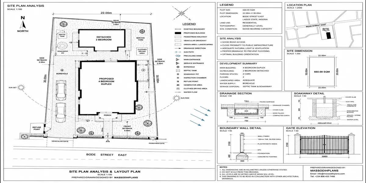
- How to Create a Site Plan: Site Analysis, Layout and Development Guide Today
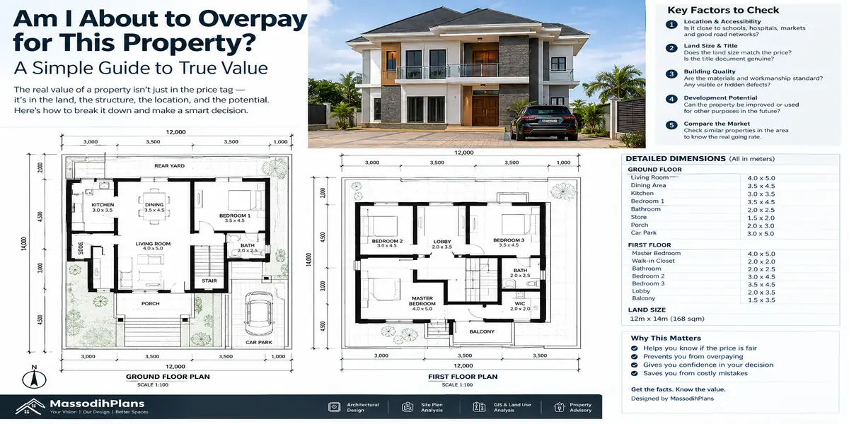
- Land and Plot Guide: How to Choose, Measure, Value and Register Property
- Construction: A Complete Guide to Building Projects, Materials and Services
Author
Massodih Okon is a Nigerian built-environment professional with academic and professional experience in urban and regional planning, geography, architectural design, Landscape Design, GIS and land development.
He holds a Master’s degree in Urban and Regional Planning from the University of Uyo and a first degree in Geography and Regional Planning.
Through MassodihPlans, he publishes practical guides on Nigerian house plans, building design, physical planning, site planning, development approval and residential construction. Read the full author profile →