How Land Use Affects the Type of Building You Can Develop in Nigeria Today
If you own land in Nigeria, one of the most important questions to ask before drawing a building plan is not “How beautiful should my house be?” but “What is this land permitted to accommodate?” Land use can determine whether your plot is suitable for a bungalow, duplex, apartment, shop, office, school, clinic, hotel, warehouse, or another form of development. It can also influence building height, density, setbacks, site coverage, parking, access, and the approvals you need.
This is where many developers make an expensive mistake: they buy land, design the building they want, and only later discover that the proposed development does not fit the planning scheme. In Nigeria, development control is used to ensure physical development follows planning policies, land-use plans and regulations, while the planning authority assesses proposals before development proceeds.
But there is a detail many articles overlook: “residential land” does not automatically mean every type of residential building is acceptable. Low-, medium- and high-density areas can have different expectations, while mixed-use, commercial, institutional and industrial locations may impose different requirements. Even an existing residential property can later face pressure for conversion when roads, businesses and infrastructure change the character of an area.
In this guide, I will show you how land use connects to the building you can develop, using Nigerian examples, site-planning logic, setbacks, density, access, parking and development approval considerations. I will explain what to check before buying land or paying for a building design, so you can avoid designing the right building for the wrong plot and losing money correcting an avoidable mistake.
By the end, you should be able to look at a plot and ask planning questions before construction.
Land Ownership and Land Use Are Two Different Questions
This is the distinction that trips up more Nigerian developers than almost anything else in the planning process.
Land ownership (or, more precisely under Nigerian law, the right of occupancy) answers: do you have a legal right to hold and use this land? A Certificate of Occupancy, a Deed of Assignment, a Governor’s Consent these documents establish that.
Land use classification answers a completely separate question: what category of development is this specific parcel of land officially designated for? Residential, commercial, industrial, mixed-use, agricultural, or institutional and within residential, often further split into low, medium, and high density.
You can hold a perfectly valid title to land classified for a use that doesn’t match what you want to build. Nigerian planning law generally requires you to develop land consistently with its approved use classification and to obtain planning permission for that specific development owning the land does not, by itself, grant you the right to build anything you want on it.
When someone tells you they “have title” to a piece of land, always ask a second question: what is the land’s approved use classification? These are two separate facts, verified through two separate channels, and conflating them is the single most common land due-diligence mistake I see.
Where Land Use Classification Actually Comes From
Each state in Nigeria regulates property development requirements through its own planning and development laws, which define zoning, land use, and building approval standards. In Lagos State specifically, the Lagos State Urban and Regional Planning and Development Law of 2010 establishes the Lagos State Physical Planning Permit Authority (LASPPPA) and the Lagos State Building Control Agency (LASBCA), which oversee planning permits and construction quality. Other states run parallel frameworks Bayelsa State’s Physical Planning and Development Law of 2015, for example, requires a Developed Property Permit and environmental clearance before construction begins.
This matters because there is no single national land use map you can check. Classification is set state by state, often layered further by local development plans, master plans for specific districts, and sometimes estate-level layout approvals that add their own restrictions on top of the state’s classification. A plot’s actual permitted use is the sum of all these layers, not just whichever one a seller chooses to mention.
The Land Use Categories That Actually Decide What You Can Build
These are the broad categories you’ll encounter, and what each one typically permits though exact permissions vary by state and specific zone.
Residential Low Density
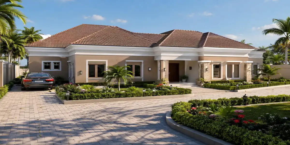
Typically permits detached single-family houses on relatively large plots, with strict limits on plot coverage and building height (often capped at two storeys). This classification exists to preserve low-traffic, low-congestion neighbourhood character, and it’s the classification most likely to reject a block-of-flats or multi-unit proposal outright, regardless of plot size.
Residential Medium Density
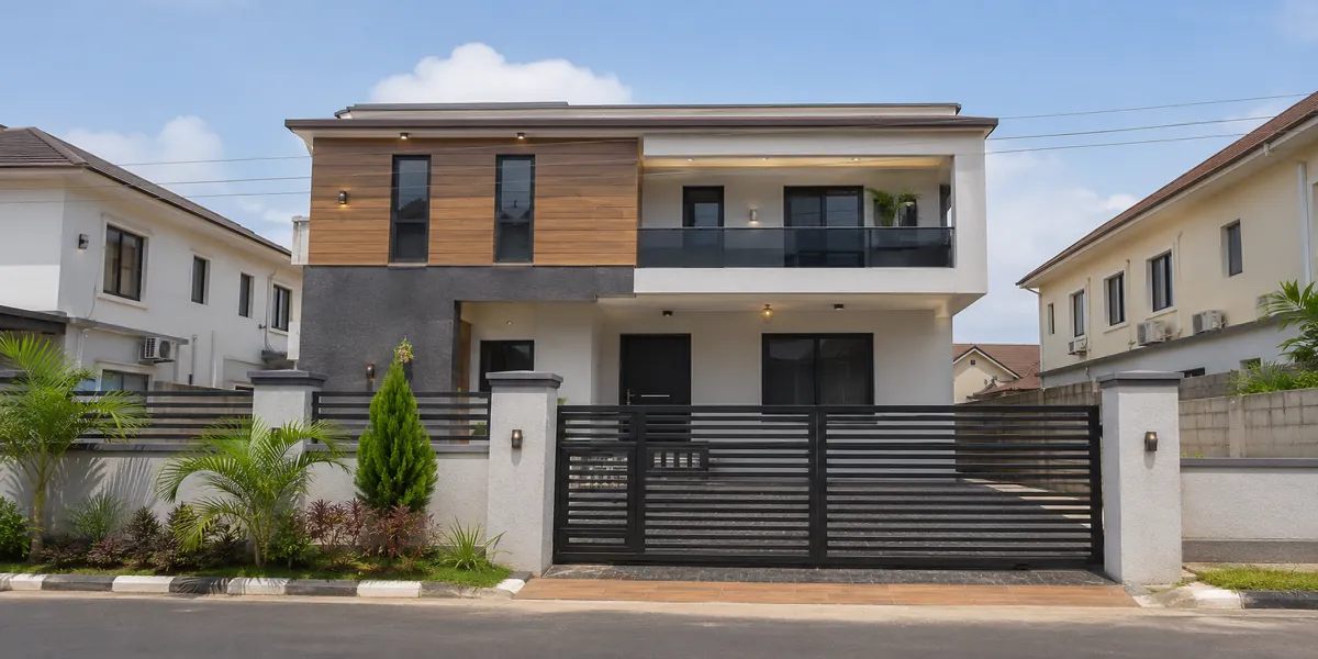
Allows a step up often semi-detached houses, terraces, or small blocks of flats (typically up to 4-6 units), with moderately relaxed setback and coverage rules compared to low density.
Residential High Density
Permits multi-unit apartment blocks, higher plot coverage, and often greater building height, reflecting an intent to accommodate more people per hectare of land. This is generally the classification developers are looking for when planning multi-tenant residential income property, and building at high density on land classified for low density is one of the most common causes of enforcement action in growing Nigerian cities.
Commercial
Designated for offices, retail, and business premises. Residential development on purely commercial land is often restricted just as commercial development is restricted on residential land the classification cuts both directions.
Mixed-Use
Explicitly permits a combination most commonly residential above commercial at street level. Mixed-use zoning, which integrates residential, commercial, and recreational spaces, is an increasingly promoted approach in Nigerian urban planning, seen as fostering vibrant communities while reducing reliance on transportation. Where available, mixed-use classification is often the most flexible option for a developer who wants both an income-generating ground floor and residential units above it.
Industrial
Reserved for manufacturing, warehousing, and heavy commercial activity, typically located away from residential zones and often with different infrastructure and environmental compliance requirements attached.
Agricultural
Land use documentation you may not think to check but absolutely should. Land still officially classified agricultural even in a fast-urbanizing area where houses are visibly already being built around it technically requires a formal change of use before any residential or commercial structure can be legally approved on it. This is an extremely common trap in Nigeria’s rapidly expanding urban fringes, where physical development on the ground has outpaced formal reclassification on paper.
Institutional / Public Use
Land set aside for schools, religious buildings, health facilities, or government use. Occasionally, land originally allocated for institutional purposes ends up informally sold or resold for private residential development a scenario that creates serious title and approval risk regardless of how legitimate the immediate seller appears.
How Density Classification Controls the Physical Building You Can Put Up
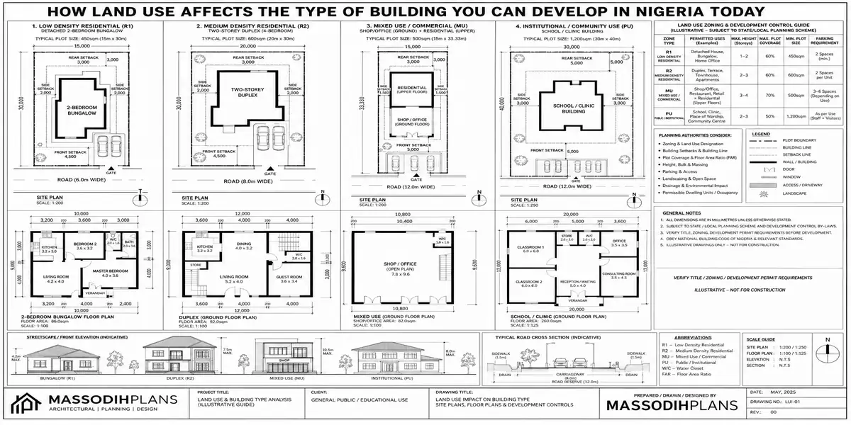
Land use category answers “what kind of activity” density classification answers “how much building.” Together they define the physical envelope of what you can construct, through three linked controls.
Plot Coverage
The maximum percentage of your plot that can be built on. Low-density residential zones often cap this around 40-50%, preserving open space and drainage capacity around the building. High-density zones permit significantly more, sometimes 60-70% or higher.
Setbacks
Minimum distances the building must sit from each boundary. These exist for light, air, drainage, and fire safety access between buildings, and they scale with density and plot size a small plot in a low-density zone can find that setback requirements alone eliminate most of its usable buildable area.
Height and Storey Limits
Directly tied to density classification. A plot zoned low-density residential will typically cap height around two storeys; medium and high-density zones permit progressively taller development, sometimes significantly so in designated high-rise corridors.
These three controls interact. A plot might technically permit a certain building footprint by coverage percentage, but combined setback requirements on a small or irregularly shaped plot can shrink the actual buildable area well below what the coverage percentage alone suggests which is exactly why a proper site and zoning analysis has to happen before, not after, a floor plan is designed.
Never assume your neighbour’s building height or plot coverage tells you what’s permitted on your own plot. Many existing buildings in Nigerian cities were constructed before current zoning was formalized, under different rules, or without full compliance “the house next door has three storeys” is not verification of what your specific plot is currently classified to allow.
Certificate of Occupancy, Land Use Classification, and Building Approval Are Three Different Things
This is worth stating plainly because the three get collapsed into one idea constantly in casual conversation about land in Nigeria.
Certificate of Occupancy (C of O) establishes your right of occupancy over the land proof you have a legal interest in it.
Land use classification establishes what category of development the land is officially designated for, independent of who owns it.
Building/planning approval is the specific permission for your particular proposed building, issued after your design is checked against the land use classification, density rules, setbacks, and building code compliance for that exact plot.
Holding a valid C of O does not automatically mean your intended building matches the land’s use classification, and matching the classification does not automatically mean your specific design will be approved each layer has to be separately satisfied.
What Actually Happens When You Build Outside Your Land’s Approved Use
This isn’t a theoretical risk. Developing a property outside its approved use can lead to enforcement actions or demolition, and developers must comply with the specific physical planning regulations of the state where their project is located, since non-compliance can lead to stop-work orders or demolition.
Beyond outright demolition, the more common consequences in practice are:
Stop-work orders that halt construction mid-project, often after significant capital has already been spent on foundation and structural work
Inability to secure building approval at all, which then blocks mortgage financing, insurance, and eventual resale, since buyers and lenders increasingly check for approved plans
Difficulty selling or transferring the property, because a buyer’s own due diligence will surface the mismatch between built structure and approved land use
Regularization costs, where correcting the mismatch after the fact through a formal change of use application is slower and more expensive than getting the classification right before construction
Change of Use: How to Legally Build Something Different From the Current Classification
If your intended development doesn’t match the land’s current classification, the land use isn’t necessarily fixed forever but it isn’t something you can resolve by simply building anyway and hoping.
A formal change of use (or land use conversion) application is submitted to the relevant state planning authority, requesting reclassification of the plot from its current designation to the one your project requires. This typically involves:
- Formal application with supporting documentation (title, survey, current classification)
- Payment of prescribed conversion fees, which vary significantly by state and by the scale of the reclassification requested
- Assessment of the surrounding area’s infrastructure capacity and existing land use pattern, since a reclassification that would overwhelm local roads or drainage is more likely to be refused
- A formal approval or refusal, which then becomes the basis for your subsequent building approval application
This process takes time and is not guaranteed to succeed which is exactly why checking classification before you buy, rather than after, is the financially safer sequence.
A Practical Due-Diligence Framework Before You Buy or Build
Most “land due diligence” content online stops at “verify the title” and “use a lawyer.” Here is the land use-specific checklist that sits alongside that title verification, not instead of it.
Obtain a formal land use/zoning confirmation from the relevant state planning authority for the specific plot not a verbal assurance from the seller or agent, and not an inference from what’s already built nearby.
Check the plot against any area master plan or layout plan covering that district, since a master plan can impose future road widening, green space reservation, or density designation that isn’t obvious from the current state of the land.
Confirm density classification specifically, not just the broad category “residential” alone doesn’t tell you whether you can build one house or an apartment block.
Ask whether the land was formally converted from a prior use (commonly agricultural to residential in newer urban-fringe areas), and request evidence of that conversion rather than assuming it happened because houses are visibly already going up around it.
Check for estate-level covenants in addition to state classification, where the plot sits within a private estate these can restrict use further than the state’s zoning does.
Match your intended building type against the confirmed density classification before commissioning architectural drawings, so your design brief starts from what’s actually permitted rather than being redesigned later around a rejection.
Land use confirmation from the planning authority is worth paying for and waiting on, even when a deal feels time-pressured. A few weeks of delay confirming classification is far cheaper than months of stalled construction after a stop-work order, or the cost of a formal change-of-use application you didn’t budget for.
A Common Pattern Worth Understanding: Emerging Axis Land
A specific scenario plays out repeatedly across Lagos’s expanding urban fringe and comparable growth corridors in other states: land in an emerging axis is sold as “residential” because development is visibly happening around it, while its formal classification on the state’s records hasn’t actually caught up it may still sit as agricultural or unclassified pending a formal master plan for the area. Buyers move fast because prices are attractive and the area is clearly urbanizing, and only discover the mismatch when they apply for building approval and it stalls.
This isn’t a sign to avoid emerging areas much of Nigeria’s most attractively priced land sits exactly in this category, and that’s precisely why it’s priced the way it is. It’s a sign to treat land use confirmation as a non-negotiable step in exactly these areas, since they’re where the gap between visible development and formal classification is widest.
Frequently Asked Questions
Does having a Certificate of Occupancy mean I can build anything I want on the land?
No. A C of O establishes your right of occupancy over the land, but the land’s separate use classification determines what type and density of building is permitted. Both have to align with your intended project.
How do I find out the official land use classification of a plot before buying?
Apply directly to the relevant state physical planning authority (such as LASPPPA in Lagos, or the equivalent agency in your state) for formal zoning/land use confirmation on the specific plot not a verbal claim from the seller or agent.
Can agricultural land be converted to residential in Nigeria?
Yes, through a formal change of use application to the state planning authority, which involves fees, documentation, and an assessment of the area’s infrastructure capacity. It is not automatic and is not achieved simply by building on the land.
What happens if I build a type of structure my land isn’t zoned for?
Consequences can include stop-work orders, refusal of building approval, demolition, and significant difficulty securing financing or reselling the property, since the mismatch between built structure and approved use is discoverable by future buyers and lenders.
Is it worth buying land in an emerging area where zoning hasn’t fully caught up with development?
It can be, given the pricing advantage these areas typically offer, but only with formal land use confirmation obtained before purchase not an assumption based on what’s already been built nearby, since visible development doesn’t confirm formal classification.
Conclusion
The plot with a clean title is not automatically the plot you can build your intended project on that second question belongs to land use classification, a separate and often overlooked layer of due diligence. The client I opened this article with eventually got his block of flats built, but on different land, after months of delay and a change-of-use application he hadn’t budgeted for on the original plot. That outcome is avoidable, and the entire cost of avoiding it is one formal zoning confirmation before you sign for land, not after.
If you’re evaluating land or planning a project and want the zoning and land use picture checked properly before you commit, our Services page outlines how we support clients through exactly this stage. Browse our Plans Library for building designs matched to different density classifications, or visit Plan School to understand the planning and approval process in more depth. You can also explore more land, planning, and building guides on our Homepage.
Related Posts
- 10 Things to Check Before Building a House on Any Plot in Nigeria Today
- How to Evaluate Land in Lagos Before Choosing a House Plan to Build Safely (15 Best Ways)
- How to Choose the Right Residential Location in Abuja Before You Build (20 Best Areas Ranked for Buildability)
- How to Choose the Right Residential Location in Lagos Before You Build
- 10 Best House Plans for Small Plots in Nigeria: What Buyers Should Consider
- How to Choose the Right House Plan Based on Your Plot Size in Nigeria Today
- How GIS Can Help You Choose the Right Land for Your Dream House in Nigeria
- How to Identify Flood Risk Before Building a House in Nigeria Today, Safely
- How to Analyse a Building Site Before Choosing a House Plan in Nigeria
- How to Check a Plot of Land Before Buying It in Nigeria: Complete Guide
- Roofing Quantity Calculator: Calculate Roofing Sheets, Timber, Nails, Ridge Caps and Accessories From Your House Plan
- How Much Does It Cost to Build a House in Nigeria? Full Guide to Materials, Labour, Foundation, Roofing and Finishing
Author
Massodih Okon is a Nigerian built-environment professional with academic and professional experience in urban and regional planning, geography, architectural design, Landscape Design, GIS and land development.
He holds a Master’s degree in Urban and Regional Planning from the University of Uyo and a first degree in Geography and Regional Planning.
Through MassodihPlans, he publishes practical guides on Nigerian house plans, building design, physical planning, site planning, development approval and residential construction. Read the full author profile →