Short answer first, because you came here for it: to get building approval in Jalingo, you need an approved survey plan or title document for the land, architectural and structural drawings prepared by a registered professional, a soil test for anything beyond a simple bungalow, and formal sign-off from the Taraba State Ministry of Lands, Housing and Urban Development working alongside the Bureau of Lands and Survey and your Local Government Area’s development control office before a single block is laid. That’s the skeleton. The flesh of it what actually trips people up, what nobody tells you about flood levels on a Jalingo plot, and how to calculate your setbacks correctly for a small plot instead of guessing is everything below.
I’m writing this the way I’d actually explain it if you sat across from me with your survey plan on the table. Not as a government press release rewritten with keywords, and not as a copy of whatever’s ranking for this search right now most of what’s currently online about building approval in Jalingo is either a generic “Nigeria building approval” article with “Jalingo” pasted into the title, or a dry list of agency names with no explanation of what any of it actually means for the plot you’re standing on. Read to the end, because the maths section on setbacks and flood levels is the part that will actually save you money and heartbreak later and it’s the part no other article on this topic bothers to include.
Why Jalingo’s Approval Process Feels Different From Lagos or Abuja
If you’ve read anything about building approval in Lagos, Abuja, or even Kaduna, you’ll notice those states have one clearly named, heavily publicized agency LASPPPA in Lagos, KASUPDA in Kaduna with a website, a fee schedule, and a documented online application portal. Jalingo, as the capital of Taraba State, doesn’t have that same single, heavily branded agency with a public-facing digital process. That’s not a flaw in your research it’s a real feature of how the state currently operates, and it’s exactly why so many homeowners get confused about who to even approach.
In Taraba, building approval authority is spread across a smaller number of institutions than you’d find in the bigger southern states, and some of what would be one dedicated planning agency elsewhere is handled through general ministries here. Understanding that structure rather than searching for an acronym that doesn’t exist is the first real problem this guide solves.
Who Actually Approves Your Building Plan in Jalingo
Three institutions matter most, and each one does a different job:
The Ministry of Lands, Housing and Urban Development is your primary point of contact for building plan approval itself reviewing your architectural and structural drawings against planning standards, land use, and safety requirements before issuing approval to build.
The Bureau of Lands and Survey, based at the Government House in Jalingo, handles land title matters survey plans, land use permits, and confirming that the land you’re building on is properly documented and free of competing claims. Its stated mission is to manage and administer land resources in Taraba State efficiently and transparently, providing accurate land information, ensuring proper land use planning, and resolving land disputes. You will almost always need to pass through this office before your building plan can even be formally assessed. tarabastategov
Your Local Government Area’s development/works department
Your Local Government Area’s development/works department (Jalingo LGA, since the city itself sits within Jalingo LGA) typically handles the ground-level practicalities site inspections, confirming boundary compliance, and in many cases the first point of contact for smaller residential projects before anything moves to the state level.
For anything beyond a standard single-family home a block of flats, a commercial building, or a project requiring an environmental impact consideration the State Ministry of Environment and, where fire safety applies, the State Fire Service, also enter the picture.
Because Taraba’s process isn’t as centralized or digitized as Lagos or Kaduna’s, procedures, required documents, and fees can genuinely vary depending on which office you first approach and how recently their requirements were updated. Treat everything in this guide as the structural framework, and always confirm the current specifics directly at the Ministry of Lands, Housing and Urban Development in Jalingo before you commit money or time this single phone call or visit will save you more than any article can.
That overlap in responsibility land title at the Bureau of Lands and Survey, design approval at the Ministry, and ground-level compliance at the LGA is precisely why so many Jalingo homeowners describe the process as “confusing.” It isn’t that the rules don’t exist; it’s that nobody has laid out, in one place, which office does what. Now that you know the division of labour, the step-by-step process below will make far more sense.
Step-by-Step: The Actual Building Approval Process
Confirm and regularize your land title first
If your land is customary (family or community) land rather than a formal government allocation, start the process of converting it to a recognized title or at least obtaining documented community consent before investing in drawings approval cannot proceed on contested or undocumented land.
Commission a survey plan if one doesn’t already exist for the plot, through a licensed surveyor registered to practice in Taraba State.
Engage a registered architect
Engage a registered architect to prepare architectural drawings specific to your plot, not a generic downloaded plan this matters enormously for the setback and plot-coverage reasons covered in the next section.
Commission structural drawings from a registered structural engineer for anything beyond a single-storey bungalow, and get a soil test done where the site history or your architect flags any concern (reclaimed ground, proximity to a river channel, or visible waterlogging history).
Submit your application package survey plan, title document, architectural and structural drawings, and any required fees to the Ministry of Lands, Housing and Urban Development, typically with a parallel or preceding check-in at the Bureau of Lands and Survey for title confirmation.
Attend or facilitate a site inspection, which confirms your plot boundaries, access, and that what’s on paper matches the actual ground conditions.
Receive your approval, which should be issued as a formal document before construction starts not a verbal assurance, not a receipt for a fee payment alone.
Keep your approval on site throughout construction, since enforcement visits can happen, and an unapproved structure risks a stop-work order or demolition regardless of how far construction has progressed.
Notice that land title regularization sits at step one, not step five. This is deliberate, and it’s the single most common reason Jalingo building projects stall people commission drawings and even start foundation work on land whose title isn’t settled, then discover the approval process can’t move forward until that’s resolved. Fix the land question before you fall in love with a design.
Documents You Will Typically Need
| Document | Why It’s Required |
|---|---|
| Survey plan | Confirms exact plot boundaries and size |
| Title document (C of O, Right of Occupancy, or recognized customary allocation) | Proves legal right to build on the land |
| Architectural drawings (floor plans, elevations, sections) | Shows what you intend to build and how it meets planning standards |
| Structural drawings and calculations | Confirms the building will stand safely; required for anything beyond a basic bungalow |
| Soil test report | Required where foundation risk is a concern flood-prone or reclaimed land, multi-storey buildings |
| Site photographs | Documents current ground condition |
| Evidence of tax/levy clearance where applicable | Confirms you’re in good standing with relevant state obligations |
| Application and assessment fee payment evidence | Required to process your submission |
This list will look familiar if you’ve researched Lagos or Kaduna’s process the fundamentals of what a planning authority needs to assess a building are broadly similar nationwide. What differs in Jalingo is the degree of formality in how these documents move between offices, which is exactly why step one above (settling your land title) matters more here than it might in a more digitized state.
The Setback and Plot Coverage Maths Nobody Explains for Small Plots
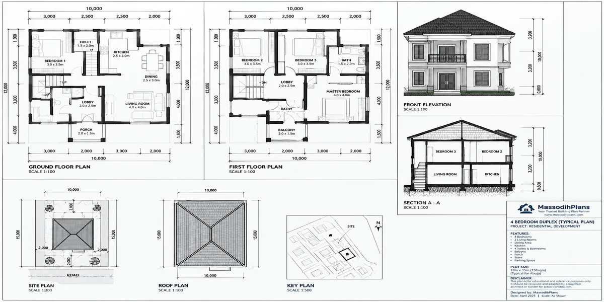
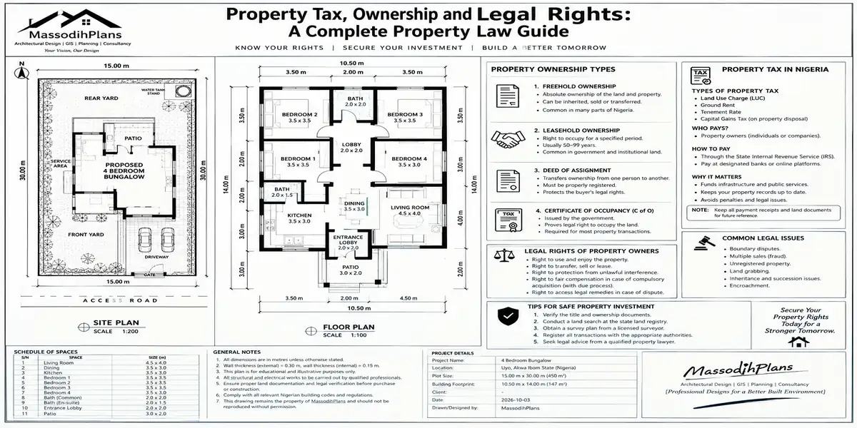
This is the section that actually connects to why MassodihPlans exists solving real design problems for people building on small plots, not just explaining bureaucracy. Because many residential plots in and around Jalingo fall into the smaller urban plot range (commonly around 15m x 30m, or 450 square metres, and sometimes smaller subdivided plots), understanding exactly how much of your plot you’re legally allowed to build on is the difference between a design that sails through approval and one that gets sent back.
Plot Coverage Ratio (PCR)
Plot Coverage Ratio tells you what percentage of your plot’s total area your building’s footprint is allowed to occupy:
PCR = (Building Footprint Area ÷ Total Plot Area) × 100
For residential buildings in most Nigerian urban planning frameworks, a typical maximum PCR falls between 40% and 50% for a standard plot, though this must always be confirmed with the Ministry for your specific plot classification, since zoning can vary by area within Jalingo.
Worked example for a standard 450 sqm (15m x 30m) plot at a 45% maximum coverage:
Maximum Building Footprint = 450 × 0.45 = 202.5 square metres
That means your ground floor footprint not your total building area if you’re going two storeys shouldn’t exceed roughly 202.5 sqm on a plot this size. This single number should shape your entire floor plan before your architect draws a single wall.
Setback Calculation
Setbacks are the mandatory distances between your building and each plot boundary. For a standard residential plot, a commonly applied minimum pattern (always to be confirmed locally) looks like this:
| Boundary | Typical Minimum Setback |
|---|---|
| Front (facing the street) | 3.0 – 4.5 metres |
| Rear | 3.0 metres |
| Sides | 1.5 metres each |
Worked example for the same 15m x 30m plot:
- Usable width after side setbacks: 15m − (1.5m + 1.5m) = 12 metres
- Usable depth after front and rear setbacks: 30m − (3.5m + 3.0m) = 23.5 metres
- Maximum theoretical building envelope: 12m × 23.5m = 282 square metres
Notice this is larger than your PCR-limited footprint of 202.5 sqm which means on this plot, your plot coverage percentage, not your setbacks, is the tighter constraint. This is exactly the kind of calculation that should happen before design, not after a plan gets rejected at the Ministry.
Always run both the Plot Coverage calculation and the Setback calculation for your specific plot before approving a design, and build to whichever number is smaller. Most rejected small-plot submissions I’ve seen fail because the design was based on setbacks alone, ignoring the coverage percentage or vice versa.
Flood-Level Calculation: A Jalingo-Specific Risk Most Guides Ignore
Taraba State sits along the Benue, Donga, and Taraba Rivers, and flooding is a real, recurring risk in the state. In April 2023, flooding affected many homes and commercial buildings across Taraba State. This is not a theoretical risk you can skip past in a generic approval guide it should directly shape your foundation and floor-level design, and it’s a conversation almost no other article on this topic has.
Minimum Floor Level Formula
A practical, widely used approach to protect a building from flood damage is:
Minimum Finished Floor Level = Highest Recorded Flood Level + Freeboard Allowance
Where the “freeboard allowance” is an additional safety margin commonly 0.3 to 0.6 metres above the highest known flood mark, depending on how conservative you want to be and what your structural engineer recommends for your specific site.
Worked example:
If the highest recorded flood level near your plot is 1.2 metres above the natural ground level, and you apply a 0.45 metre freeboard allowance:
Minimum Finished Floor Level = 1.2m + 0.45m = 1.65 metres above natural ground level
This single calculation done before foundation work, not after a flood is the difference between a home that stays dry through a rainy season like April 2023’s and one that doesn’t. Ask your Ministry contact or an experienced local engineer about documented flood levels for your specific area of Jalingo before finalizing your foundation design; this is a question worth asking even if nobody at the counter raises it first.
If your plot sits anywhere near the Taraba, Donga, or Benue River floodplains, or in any area of Jalingo with a known history of waterlogging, treat the flood-level calculation above as mandatory, not optional regardless of whether the approval process itself formally requires it. Approval protects you legally; this calculation protects your investment physically.
Estimating Approval Costs: A Practical Framework
Because exact fee schedules in Taraba are not as publicly documented or standardized as in Lagos or Kaduna, the honest and responsible thing to do here is give you a framework for estimating cost rather than a specific number that may already be outdated by the time you read this.
Estimated Total Approval Cost ≈ Base Application/Assessment Fee + (Floor Area × Development Levy Rate per sqm) + Professional Fees (survey, soil test, drawing preparation)
Each component varies by plot size, building type, and current ministry rates, which is exactly why you should request a written cost breakdown from the Ministry of Lands, Housing and Urban Development directly rather than relying on any article including this one for exact figures. What this framework does give you is the ability to ask the right question when you get there: “What is the base assessment fee, what is the per-square-metre development levy, and are there any additional charges for my specific plot classification?” Asking it this way, broken into its components, tends to get you a far more complete answer than simply asking “how much will approval cost.”
Realistic Timeline
| Stage | Typical Duration |
|---|---|
| Land title confirmation/regularization | Days to several weeks, depending on whether title already exists |
| Survey plan preparation (if needed) | 1 – 3 weeks |
| Architectural and structural drawing preparation | 2 – 6 weeks, depending on complexity |
| Application submission and review | Several weeks, variable |
| Site inspection and final approval issuance | Variable, often the least predictable stage |
Build buffer time into your overall project schedule rather than assuming a fixed number of weeks the least digitized stage of this process is also the hardest to predict precisely, and planning your construction start date around an optimistic approval timeline is a common and avoidable source of project delay.
Common Reasons Building Plans Get Rejected or Delayed in Jalingo
Unresolved or undocumented land title — the single biggest cause of stalled applications, as covered above
Drawings that ignore plot coverage and setback limits, often because a generic downloaded plan was used instead of a site-specific design
No soil test where foundation risk is genuinely present, particularly near flood-prone or previously waterlogged ground
Incomplete document sets submitted in the hope that missing items can be supplied “later”
Design that doesn’t account for the specific flood-level reality of the plot, leading to problems that surface after approval, during or after construction, rather than before
Building Approval for Diaspora and International Clients
If you’re reading this from the US, UK, Germany, the UAE, Canada, Switzerland, Luxembourg, Iceland, Qatar, Australia, or Singapore and planning to build in Jalingo for family, retirement, or investment purposes, the process above still applies to you in full but a few additional realities matter:
A Power of Attorney, properly drafted and notarized, is essential if you cannot be physically present for site inspections, document submission, or title regularization. Appoint someone you trust completely, since this document gives them real authority over your land matters.
Land title verification matters even more from a distance. Commission an independent search and verification of the land’s title before transferring any significant funds, rather than relying solely on the word of a local contact.
Currency and timing: naira-denominated fees and material costs shift with exchange rates and local inflation, so get costs reconfirmed close to the point of payment rather than acting on figures from months earlier.
Professional oversight from a distance is non-negotiable. Engage a registered architect and, ideally, an independent supervising professional who reports to you directly, not only to your on-ground relative or contact, so design and construction decisions are checked against your actual brief and the approval conditions.
How This Connects to Designing for Your Actual Plot
Here’s the part that ties everything above back together: every number in the setback and plot-coverage section isn’t bureaucratic trivia it is the actual design brief for your house. A 450 sqm plot with a 202.5 sqm maximum footprint and the setback pattern worked through above doesn’t just need “a 4 bedroom design.” It needs a design specifically planned to fit that exact footprint, on that exact plot shape, with those exact setbacks respected on all four sides which is a completely different design problem from fitting the same bedroom count onto a 600 sqm or 1,000 sqm plot.
This is precisely the gap most Nigerian house-plan content leaves open: beautiful designs that assume a generous plot, dropped onto readers who are actually working with 450 sqm, 400 sqm, or even smaller subdivided urban plots common in cities like Jalingo. Solving that mismatch real, buildable designs sized correctly for small and standard Nigerian plots, not just borrowed from plans meant for much larger land is the actual problem this platform exists to solve.
Frequently Asked Questions
Which agency approves building plans in Jalingo?
Primarily the Taraba State Ministry of Lands, Housing and Urban Development, working alongside the Bureau of Lands and Survey for land title matters and your Local Government Area’s development office for ground-level compliance.
Can I build on customary (family) land in Jalingo without converting the title?
You can, in practice, but it significantly increases your risk of approval delays, future disputes, and difficulty proving ownership. Regularizing or at least formally documenting the land before applying for building approval is strongly advisable.
How do I calculate how much of my plot I can build on?
Use the Plot Coverage Ratio formula (Building Footprint Area ÷ Total Plot Area) × 100 and compare it against your setback-constrained maximum envelope. Build to whichever figure is smaller, as shown in the worked examples above.
Is flooding a real concern for building in Jalingo?
Yes. Taraba State has experienced significant flooding affecting homes and buildings, and any plot near a river floodplain or with a history of waterlogging should have its foundation level calculated against documented flood levels, not just standard practice.
Can I manage the entire building approval process from abroad?
Yes, with a properly notarized Power of Attorney, independent land title verification, and a registered professional on the ground reporting directly to you all covered in the diaspora section above.
Finally
Building approval in Jalingo isn’t more complicated than Lagos or Kaduna’s process it’s just less centralized and less documented online, which is exactly why confusion about who does what has been allowed to persist. Settle your land title first, run the plot coverage and setback maths before you fall in love with a design, take Taraba’s flood history seriously in your foundation planning, and confirm every fee and procedural detail directly with the Ministry rather than from any single article. Do that, and you’ll be building on solid legal and physical ground, in every sense of the phrase.
If you’re working with a small or standard-sized plot in Jalingo or anywhere else in Nigeria, browse our Plans Library for designs actually sized to fit typical Nigerian plot dimensions, or visit Plan School to learn how to read a plan against your own plot’s setback and coverage limits before you commission one. If you’d like direct support navigating your specific plot’s approval and design together, our Services page outlines how we work with clients from land verification through to approved, buildable drawings. You can also explore more city-specific and state-specific building guides on our Homepage.
- Nigerian House Plans for Narrow Plots in Ado-Ekiti: The Complete Design Guide
- House Plans for 450sqm Plots in Asaba: Best Designs
- What Are the Best Nigerian House Plans for Australian Property Investment?
- How Can I Build a House in Nigeria From Canada on a Small Plot?
- What Nigerian House Plans Are Best for Canadian Property Investors?
Author
Massodih Okon is a Nigerian built-environment professional with academic and professional experience in urban and regional planning, geography, architectural design, Landscape Design, GIS and land development.
He holds a Master’s degree in Urban and Regional Planning from the University of Uyo and a first degree in Geography and Regional Planning.
Through MassodihPlans, he publishes practical guides on Nigerian house plans, building design, physical planning, site planning, development approval and residential construction. Read the full author profile →