Master Planning: How to Prepare a Master Plan for Cities, Estates and Towns
Introduction to Master Planning: How to Prepare a Master Plan for Cities, Estates and Towns
Let’s clear up something first, because it trips up almost every client and student I’ve sat across a table with: a “master plan” is not a drawing. The drawing is the last thing that gets produced, not the thing itself. A master plan is a decision a documented, agreed decision about where growth goes, what gets protected, what gets built first, and who pays for what and the layout you eventually see on paper is just that decision made visible.
I say this upfront because most articles ranking for this topic jump straight to pictures of coloured land-use maps, and readers walk away thinking a master plan is basically a fancy site plan with more colours. It isn’t. And if you approach preparing one that way start with the drawing instead of the decision you end up with something that looks impressive in a presentation and falls apart the moment implementation starts, which is the single most common failure I’ve watched happen to cities, estates, and private developers alike.
This piece is written to actually walk you through preparing one whether you’re a planning student trying to understand the process, a private developer commissioning an estate master plan, or a local government official responsible for a town’s growth. I’ll define every version of this term you’re likely to search for, show you the real preparation process step by step, and then break down how the rules differ depending on where in the world you’re doing this because “master plan” means something legally specific in one country and something purely advisory in another, and nobody tells you that until you’ve already made an expensive mistake.
What a Master Plan Actually Is (and What It Isn’t)
A master plan is a long-term, comprehensive planning document that sets out how a defined area a city, town, estate, campus, or site should grow and be organized over a stated period, usually 10 to 25 years. It typically covers land use, transportation, infrastructure, housing, public space, and implementation priorities, and it’s built on data, public input, and technical analysis rather than opinion.
What it isn’t: a final architectural design, a construction drawing, or a fixed blueprint that never changes. A master plan is deliberately flexible at the detail level and firm at the structural level it fixes the big moves (where the main road goes, where the green corridor sits, what density belongs where) and leaves the fine-grained design of individual buildings to the architectural and engineering stages that follow.
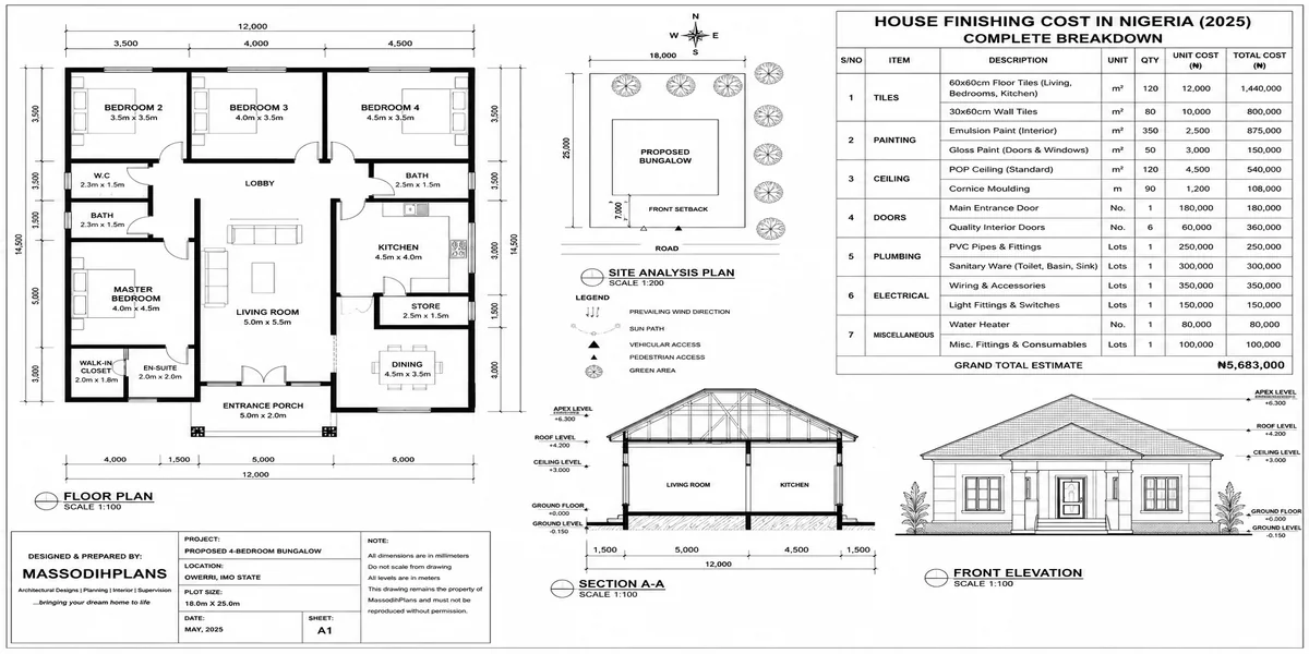
This distinction is where I see the most confusion, especially from private clients who ask for “a master plan” when what they actually need is a layout plan or a site plan for a single estate. A city or regional master plan is a policy and land-use document, produced by or for a planning authority, usually with statutory weight. An estate or site master plan, by contrast, is typically a private planning and design document still comprehensive, still long-term in its thinking, but without the same legal force unless a local authority formally adopts it.
Before you commission anything, ask yourself one question am I trying to set policy for how an area develops, or am I trying to lay out a specific piece of land I already own or control? The first is a master plan in the full statutory sense. The second is what most private clients actually need, and it should be scoped and priced very differently.
Master Planning as a Process, Not a Document
And “Master planning” (the verb form of this whole topic, and one of the most searched variations) is the process that produces a master plan and understanding the process matters more than owning the final drawing, because the process is where the real decisions get made and defended.
Master planning typically runs through five overlapping stages:
1. Baseline and site analysis. Before anyone draws anything, you gather and analyze what already exists topography, soil and drainage conditions, existing land use, population data, infrastructure capacity, ecological features, and legal/title constraints. Skipping this stage is the single biggest reason master plans fail at implementation; you cannot plan for a place you haven’t actually studied.
2. Stakeholder and community engagement. A master plan that ignores the people who live in or near the area is a master plan that gets resisted, litigated, or ignored once implementation starts. Genuine engagement not a single token public meeting surfaces real constraints (informal land rights, existing livelihoods, cultural sites) that a desk study alone will miss.
3. Vision and goal-setting. This is where the plan’s direction gets agreed: what kind of place is this meant to become, and what are the measurable goals housing units, green space ratio, employment targets, transport modal split that will tell you if you’ve succeeded.
4. Concept and structure planning. This is where the “big moves” get fixed the main movement network, the broad land-use structure, density gradients, and open space framework. This stage produces alternative concept options that get tested and compared before one is selected.
5. Detailed layout, drawing, and implementation framework. Only now does the plan get resolved into detailed land-use zones, a phasing strategy, an infrastructure plan, and the drawings and guidelines that will actually guide approvals and construction going forward.
Most “how to make a master plan” content online skips straight from stage 1 to stage 5, which is exactly why so many master plans city and private alike end up as pretty pictures nobody can actually implement.
Master Plan Design: The Principles Behind a Plan That Actually Works
“Master plan design” refers to the design thinking applied within the concept and structure stage above the actual spatial and organizational decisions that separate a workable plan from a wish list. A handful of principles show up in every master plan design that has genuinely stood the test of implementation:
Connectivity before density. Decide the movement network roads, paths, transit corridors before you finalize land use and density, because retrofitting connectivity into an already-zoned area is dramatically more expensive than designing it in from the start.
Phasing built into the structure, not added afterward. A good master plan design is drawn so that each phase is independently functional and serviceable you should never need to complete phase 3 for phase 1 to have working roads, drainage, and utilities.
Density that responds to infrastructure capacity, not just land value. Assigning high density to an area because the land is valuable, without checking whether roads, water, and power can actually support that density, is one of the most common design failures in fast-growing markets.
Legible structure. People should be able to understand a place’s organization by moving through it a clear hierarchy of streets, a recognizable central space, a readable relationship between public and private zones rather than relying on signage to explain a confusing layout.
Genuine flexibility for change. Land use assumptions made today, especially around retail and commercial demand, are often wrong within a decade. Good master plan design builds in blocks and parcels that can shift use over time without requiring the entire structure to be redrawn.
Every Type of Master Plan, Explained by What It’s Actually For
This is the part most competing articles either skip or blur together. Each of these terms gets searched because each one solves a genuinely different problem here’s what distinguishes them.
Urban Master Plan
An urban master plan covers a city or a substantial urban area, addressing land use, transport, infrastructure, and growth management at a scale that affects multiple neighbourhoods or districts. It’s usually a statutory document prepared or approved by a city or metropolitan planning authority, and it forms the legal basis for zoning and development control decisions across that whole urban area.
City Master Plan
Functionally similar to an urban master plan but scoped specifically to a city’s administrative or jurisdictional boundary. A city master plan for a city and often its surrounding metropolitan region defines an achievable vision for the whole agglomeration’s future while addressing its most immediate infrastructure and housing needs. This is the document that, in most countries, has direct legal weight over what individual landowners can and cannot build.
Community Master Plan
Scoped to a specific community or district within a larger city smaller than a full urban master plan, but still comprehensive across land use, facilities, and public space. Community master plans are common where a distinct neighbourhood or ward needs its own detailed direction that a citywide plan is too broad to provide, and they usually have to align with (not contradict) the citywide master plan above them.
Estate Master Plan
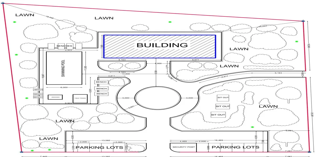
A private planning document covering a residential, mixed-use, or gated estate development the scale most private developers and diaspora clients actually need. An estate master plan defines the internal road network, plot layout, land use zoning within the estate, utility and drainage infrastructure, communal facilities, and phasing, and it must still comply with the wider city or urban master plan and zoning it sits inside.
Residential Master Plan
Similar to an estate master plan but the term is used more broadly for any residential development’s overall layout plan whether a single estate, a housing scheme, or a residential district within a larger master plan. It focuses specifically on housing typologies, densities, plot sizes, and the residential support infrastructure (schools, clinics, local shops) needed to serve the population it houses.
Development Master Plan
A general term covering the master plan for any large-scale development project residential, commercial, mixed-use, or institutional that isn’t strictly a full urban plan. This is often the term used when a private developer or investor is preparing a comprehensive plan for a large parcel of land intended for phased, multi-use development.
Site Master Plan
The most granular version a comprehensive plan for a single, defined site (a campus, a factory complex, a single large estate, a resort). A site master plan still covers land use, circulation, infrastructure, and phasing, but at the scale of one ownership boundary rather than a district or city.
Land Development Master Plan
Emphasizes the development sequencing and engineering side of a master plan how raw or underutilized land gets brought online for development, including earthworks, drainage, utility extension, and access road construction ahead of building. This term is used heavily in the private development and construction sector, where the “master plan” conversation is really about de-risking and sequencing land development investment.
Neighbourhood Master Plan
Scoped even smaller than a community master plan typically a single neighbourhood’s detailed land use, street network, and public space plan, nested inside a community or city master plan. This is the scale at which walkability, local facility access, and street-level design detail actually get resolved.
Industrial Master Plan
Covers the layout of an industrial estate, park, or zone plot allocation for different industry types, heavy vehicle access and turning circles, utility capacity (power, water, waste) sized for industrial rather than residential demand, buffer zones from residential areas, and often specific environmental and safety zoning that residential or commercial master plans don’t need to address at all.
Institutional Master Plan
Covers a single institution’s land a university campus, hospital complex, or government administrative estate. Institutional master plans have to balance long-term expansion capacity against a fixed or slow-growing land boundary, and they typically integrate specialized facilities (laboratories, teaching hospitals, dormitories) that don’t appear in general residential or commercial planning.
Township Master Plan
Covers a new or expanding township larger than a single estate but often smaller or more self-contained than a full city, frequently built around a planned new settlement with its own designated town centre, housing, schools, and employment areas from the outset rather than growing organically.
New Town Planning
The broadest and most policy-driven of this group the deliberate planning and development of an entirely new settlement, usually government-led or government-enabled, intended to relieve pressure on an existing city or open up a new growth corridor. New town planning master plans have to solve problems ordinary urban or estate master plans don’t: bootstrapping an economy and job base from nothing, sequencing infrastructure investment before any resident has moved in, and building enough initial critical mass that the town doesn’t stall as a half-built ghost development a failure pattern that has played out in new town projects across several countries when this sequencing was gotten wrong.
Master Plan Layout: How the Pieces Actually Get Arranged
The “layout” is the spatial arrangement decision within the plan how land uses, movement routes, and open space are actually placed relative to each other on the ground. A well-structured master plan layout typically follows a consistent internal logic:
Movement network first the primary and secondary road hierarchy, pedestrian routes, and (where relevant) transit corridors are fixed early, because almost everything else is organized around access to this network.
Land use zones assigned along that network higher-intensity uses (commercial, mixed-use, higher-density housing) typically sit along primary routes and nodes; lower-intensity residential sits in the quieter interior blocks.
Open space and green infrastructure woven through, not left over parks, drainage corridors, and buffer strips are placed deliberately as part of the structure, not squeezed into whatever land is left after everything else is allocated.
Community facilities positioned for actual walkable access schools, clinics, and local markets placed so that most residents can reasonably reach them without needing a car, rather than positioned wherever a convenient leftover plot happened to be.
Utility and drainage infrastructure routed to follow the layout’s natural topography gravity-fed drainage routes and utility corridors that follow the site’s natural slope cost significantly less to build and maintain than a layout that fights the land’s natural contours.
Note, A master plan layout that looks balanced and attractive on paper but ignores the site’s actual topography and drainage pattern is one of the most expensive mistakes to discover after implementation begins. Always have a topographic and drainage survey completed and reviewed before the layout stage is finalized not after.
Master Plan Drawing: Standards, Scale, and What Should Actually Be On It
A “master plan drawing” is the graphic output of everything above, and it needs to communicate clearly to very different audiences approving authorities, engineers, investors, and future residents which means it has to follow some consistent drawing conventions to actually do its job.
A complete master plan drawing set typically includes:
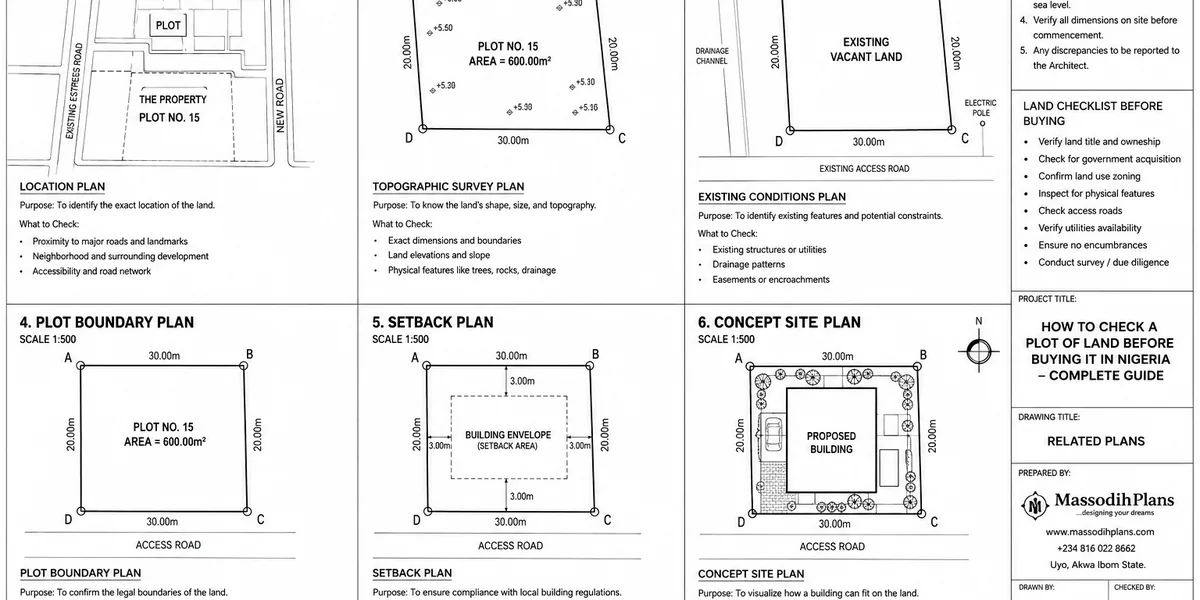
A base/context plan showing the site’s boundary, surrounding context, and existing conditions
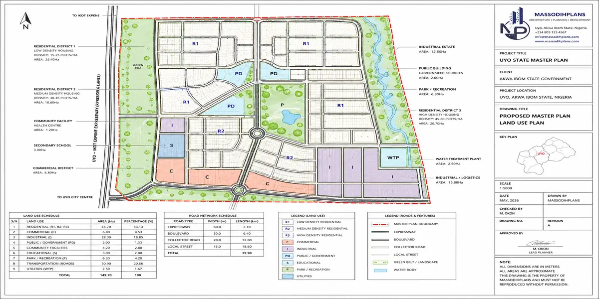
A land use plan with a colour-coded key showing every proposed zone (residential, commercial, institutional, open space, industrial, etc.)
A circulation/movement plan showing the road hierarchy, pedestrian routes, and any transit elements
An infrastructure plan showing utility corridors, drainage routes, and major infrastructure nodes
A phasing plan showing which parts of the development happen in which sequence, usually colour-coded by phase
A density/height plan, where relevant, showing how building height or density varies across the site
Illustrative or 3D concept views, used for communication and buy-in but never a substitute for the technical drawings above
Scale matters more than most people preparing a first master plan realize a citywide master plan is usually drawn at a scale that shows structure and zoning (commonly in the range of 1:5,000 to 1:25,000, depending on the city’s size), while an estate or site master plan is drawn at a much more detailed scale (typically 1:500 to 1:2,000) that shows actual plot boundaries and road widths. Drawing an estate master plan at a citywide scale or vice versa is a common mistake that produces a drawing too vague to actually implement or too detailed to communicate the big picture.
Master Plan Example: What a Real One Actually Contains
Rather than showing you a single generic example image (which is what most competing articles do and which teaches you almost nothing), here’s what a genuinely complete master plan example for, say, a 50-hectare mixed residential estate should actually contain as a document package, because this is what you should be checking for when you’re handed one:
- An executive summary stating the vision, goals, and key statistics (total units, density, population capacity, land use split)
- A baseline analysis section covering topography, soil, existing conditions, and constraints
- The land use plan with a full zoning breakdown by area/percentage
- The circulation and movement plan
- The infrastructure plan (water, power, drainage, sewage/waste)
- The open space and landscape framework
- The phasing and implementation plan, including estimated timelines per phase
- Design guidelines for future development within each zone (see below)
- A summary of stakeholder/community input and how it shaped the final plan
- The full drawing set at appropriate scale, as outlined above
If a document handed to you as a “master plan” is missing more than two or three of these, what you actually have is a layout sketch or a concept useful as a starting point, but not yet a master plan in the full sense of the term.
Master Plan Design Guidelines: Turning the Plan Into Rules Others Can Follow
Design guidelines are the part of a master plan that governs how individual buildings and plots within it get developed after the master plan itself is approved and they’re what stop a good master plan from being slowly undone, one inconsistent building at a time, over the years it takes to build out.
A solid set of master plan design guidelines usually covers:
Setbacks and building lines specific to each zone within the plan, not just a blanket citywide standard
Maximum height and density per zone, tied directly to the infrastructure capacity that zone was actually designed for
Architectural character guidance material palette, roofline expectations, facade treatment detailed enough to maintain visual coherence but flexible enough not to force identical buildings
Frontage and street-engagement rules how buildings should meet the street, fencing height limits, active frontage requirements near public space
Signage and landscaping standards for shared and public-facing areas
A review or approval process for individual building submissions within the estate or district, so guidelines are actually enforced rather than aspirational
The estates and townships I’ve seen age well over 10-15 years are, almost without exception, the ones where design guidelines were enforced consistently from the first plot sold not just written into a document nobody referenced again after approval.
The Master Planning Process, Step by Step
Bringing everything above together, here’s the practical sequence I actually walk clients through, whether the project is a city district or a private estate:
Define the brief and scope
What area, what is it for, who is the client or authority, and what is the plan’s intended legal or practical status once complete?
Commission baseline studies
Topographic survey, soil investigation, drainage assessment, existing land use and infrastructure capacity study, and for larger public projects demographic and economic analysis.
Engage stakeholders early, not at the end
Landowners, residents, relevant authorities, and (for larger plans) the wider public need a genuine opportunity to shape the vision, not just react to a finished concept.
Develop and test concept alternatives
At least two or three structural concepts should be developed and compared against the baseline data and stated goals before one is selected a master plan built from a single, unchallenged concept is a much weaker plan.
Resolve the selected concept into a detailed layout
Movement network, land use zones, open space, and infrastructure routing are all resolved together, because a change to one almost always affects the others.
Prepare the infrastructure and phasing plan
Determine what gets built in what sequence, and confirm that each phase is independently serviceable.
Draft the design guidelines that will govern development within the plan going forward.
Prepare the full drawing set and supporting document
Everything listed in the “master plan example” section above gets compiled here.
Submit for approval where the plan requires statutory sign-off city and regional master plans almost always do; private estate plans usually need at least local planning authority approval even where the plan itself isn’t a statutory document.
Implement, monitor, and revise. A master plan is not “finished” once approved it needs periodic review against how the area is actually developing, because population growth, market shifts, and infrastructure realities rarely track the original assumptions exactly.
Make sure you Build a review point into the plan itself a stated commitment to revisit the master plan every 5 years, for instance rather than treating it as a document you write once and never touch again. Every master plan I’ve seen age badly was one nobody had a mandate to formally update.
Master Plan Preparation Around the World: What Actually Differs by Country
This is the layer almost no article on this topic covers properly, and it matters enormously if you’re preparing or reviewing a master plan outside a single country’s system. The core planning logic above is universal the legal weight, required approvals, and terminology are not.
Nigeria
Master plans (state, regional, and city) are prepared under state Urban and Regional Planning laws, most of which are modelled on the Nigerian Urban and Regional Planning Act. State planning authorities (such as Lagos State’s planning bodies or equivalent agencies in other states) prepare and approve statutory master plans, while private estate master plans still require layout approval from the relevant state authority before individual plots can be legally developed.
United States
Master plans (often called “comprehensive plans” at the city level) are typically prepared by municipal planning departments and adopted by city council, guiding zoning ordinances rather than directly regulating individual buildings themselves; zoning is the actual regulatory tool derived from the plan.
United Kingdom
The closest statutory equivalent is the “Local Plan,” prepared under the Town and Country Planning framework by local planning authorities; “master plan” in the UK is more commonly used for a specific site or development brief (a “development framework” or “area action plan”) rather than the citywide statutory document itself.
Canada
Municipalities prepare “Official Plans” (Ontario) or equivalent statutory plans under provincial planning legislation, functioning much like a master plan but under different provincial names depending on jurisdiction.
Australia
State-based planning schemes govern land use, with “structure plans” or “precinct plans” commonly used for the master-plan-scale document guiding a growth area or estate, prepared under each state’s planning legislation.
Singapore
Has one of the most centralized systems: the Urban Redevelopment Authority prepares a statutory Master Plan reviewed roughly every five years, translating the long-term Concept Plan into detailed land use zoning with direct legal effect.
United Arab emirate (UAE)
Major emirates prepare their own long-term urban master plans (such as Dubai’s and Abu Dhabi’s structural framework plans) through dedicated municipal or urban planning authorities, often with an unusually long planning horizon (20-40 years) tied to national economic diversification strategy.
South Africa
Spatial Development Frameworks (SDFs), prepared under the Spatial Planning and Land Use Management Act, function as the statutory master-plan-equivalent at municipal level, guiding zoning and land use decisions.
Germany
The “Flächennutzungsplan” (land use plan) at municipal level and “Bebauungsplan” (binding land use plan) at the detailed level together perform the master plan’s role, prepared under the Federal Building Code (Baugesetzbuch).
Netherlands
The “bestemmingsplan” (zoning plan) is the statutory instrument, though Dutch planning practice also uses “structuurvisie” (structure vision) documents for longer-term, less legally binding master-plan-style thinking at city or regional scale.
France
The “Schéma de Cohérence Territoriale” (SCoT) sets the strategic framework at a territorial scale, while the “Plan Local d’Urbanisme” (PLU) is the detailed statutory land use plan at municipal level.
Switzerland, Austria, Belgium, Luxembourg
Each generally follows a similar cantonal/regional-plus-municipal two-tier structure common across continental Europe, with a broader strategic spatial plan at regional level and a legally binding land use plan at municipal level.
Sweden, Denmark, Norway, Finland
The Nordic countries typically use a “comprehensive plan” (municipal level, strategic and non-binding) paired with a “detailed/local plan” (legally binding, site-specific), splitting the master plan’s dual role of vision-setting and legal control across two separate documents.
Ireland
Local authorities prepare statutory Development Plans under the Planning and Development Act, reviewed on a set cycle and functioning as the master-plan-equivalent instrument guiding zoning and development management.
New Zealand
District and regional councils prepare statutory Plans under the Resource Management Act (progressively being reformed), which set out land use zoning and development rules in a manner functionally similar to a master plan.
Very Important (Before You Prepare One): If you’re working across borders a diaspora client planning to develop in Nigeria while living abroad, or a firm bidding on international planning work never assume the term “master plan” carries the same legal weight or approval pathway from one country to the next. Always confirm the specific statutory instrument and approval authority that actually governs the jurisdiction you’re working in before treating any plan as final.
Common Mistakes That Undermine a Master Plan
Starting with the drawing instead of the data producing an attractive layout before the topographic, drainage, and demand analysis is complete, then having to unwind decisions once the data comes in
Designing for land value instead of infrastructure capacity assigning density that the roads, water, and power systems were never sized to support
Treating public/stakeholder engagement as a formality a single presentation rather than a genuine process, which almost guarantees resistance or legal challenge later
No enforcement mechanism for design guidelines guidelines that exist on paper but aren’t actually checked against submitted building plans
No built-in review cycle treating the plan as permanently fixed rather than a living document that needs revisiting as conditions change
Ignoring phasing viability a beautiful full-build-out plan that has no functioning early phase, so nothing works until everything is finished
Frequently Asked Questions
What is the difference between a master plan and a site plan?
A master plan covers a whole area’s long-term structure, land use, and phasing across multiple stages of development. A site plan is a detailed drawing of one specific development at one point in time a master plan can contain several site plans nested within it as different phases are detailed and built.
Who prepares a master plan?
For a city, region, or statutory area, a government planning authority prepares or commissions it, usually through qualified town/urban planners. For a private estate, site, or institutional campus, the landowner or developer commissions a planning and design team typically a town planner working with architects, engineers, and surveyors to prepare it.
How long does it take to prepare a master plan?
For a private estate or site master plan, expect roughly 3 to 9 months depending on site size and complexity. For a city or regional master plan, the full process including baseline studies, public engagement, and statutory approval commonly takes 1 to 3 years.
Does a master plan have legal force?
It depends entirely on the jurisdiction and the plan’s status. A statutory city or regional master plan (or its local equivalent comprehensive plan, local plan, zoning plan) usually has direct legal weight over development decisions. A private estate master plan generally needs separate approval from the relevant planning authority before it carries legal weight for the plots within it.
Can a master plan be changed after approval?
Yes, and it usually should be periodically. Most well-run master plans include a formal review cycle (commonly every 5 years for city-scale plans) to adjust for population growth, market shifts, and infrastructure realities that the original plan couldn’t fully predict.
Finally, Listen
A master plan earns its name by doing something a simple layout drawing never can it turns a scattered set of assumptions about growth, land, and infrastructure into one coordinated, defensible decision that everyone building on that land afterward has to work within. The plans that actually hold up over 10 or 20 years are the ones where the data came before the drawing, the phasing was honest about what could function on its own, and someone had the authority to come back and adjust it as reality diverged from the original assumptions not the ones that simply looked the most impressive in the first presentation.
If you’re at the stage of commissioning a master plan for an estate, site, or development project, our Services page outlines how we approach master planning from baseline analysis through to detailed layout and guidelines. Browse our Plans Library for examples of estate and residential layouts developed from this process, or visit Plan School to go deeper into how planning approvals and statutory processes actually work. You can also explore more town planning and urban design guides on our Homepage. International guidelines on urban and territorial planning. Read about these also:
- Urban Design Guide: Principles for Walkable, Connected and Livable Places
- Town Planning: How Urban Development, Land Use and Planning Permission Work
- Mortgage Home Finance: How to Calculate Rates, Payments and Home Loan Costs
- Property Management: Complete Guide to Managing Rentals and Property Safely
- Land and Plot Guide: How to Choose, Measure, Value and Register Property
- How do I deal with a difficult tenant? Practical Guide for Property Owners!
Author
Massodih Okon is a Nigerian built-environment professional with academic and professional experience in urban and regional planning, geography, architectural design, Landscape Design, GIS and land development.
He holds a Master’s degree in Urban and Regional Planning from the University of Uyo and a first degree in Geography and Regional Planning.
Through MassodihPlans, he publishes practical guides on Nigerian house plans, building design, physical planning, site planning, development approval and residential construction. Read the full author profile →