Urban Design Guide: Principles for Walkable, Connected and Livable Places
Introduction to Urban Design Guide: Principles for Walkable, Connected and Livable Places
Stand at two different street corners and you’ll feel the whole subject of urban design in about four seconds, no textbook required.
Corner one: a market street in an older Nigerian town shops spilling slightly onto the walkway, someone selling roasted corn from a stool, a tricycle dropping off a passenger, people actually walking because there’s something worth walking to every twenty metres. It’s noisy, it’s a little chaotic, and it works.
Corner two: a brand-new estate a few kilometres away wide tarred roads, uniform fences, a security post at the gate, and almost nobody outside. You need a car to buy bread. The houses might be nicer. The street is dead.
Both of those places were designed by someone, whether that person had the title “urban designer” or not. One of them just happened to get more of the underlying principles right, mostly by accident. This guide exists so the next place doesn’t have to rely on accident. I’m writing it from the town planning side of my work not the architecture side because this is genuinely a separate skill from designing a single building, and it’s the one most homeowners, developers, and even some students never get taught in plain language.
What Urban Design Actually Covers
Urban design sits between two things people usually understand separately: individual buildings (architecture’s job) and city-wide policy (planning’s job). It’s the layer in between how streets, blocks, plots, and public spaces are arranged so that a collection of buildings functions as an actual place, not just a cluster of structures that happen to share a postcode.
Practically, urban design decides things like: how wide a street is and what lines it, whether a plot faces a shared green space or a blank wall, how far you can walk before finding a shop, whether a footpath actually leads anywhere useful, and whether the drainage running past a market stall was designed on purpose or just happened.
If that sounds unglamorous compared to skylines and renderings, that’s the point. Good urban design is mostly invisible when it’s working. You only notice it when it’s absent when you’re standing on a corner two like the one above, wondering why a well-built neighbourhood still feels empty.
Urban Design Principles: The Ones That Actually Change How a Place Feels
There’s a long academic list of urban design principles out there. Most of them collapse into a handful that matter in practice. Here they are, explained the way I’d explain them to a client standing on their own plot for the first time.
Connectivity
Can people get from A to B by more than one route? A neighbourhood built around a single entrance road feeding everything else is fragile one blockage, one flood, one okada accident, and the whole area is stuck. A grid, even a rough one, spreads that risk and cuts actual walking and driving distances.
Human scale
Buildings, fences, and streets should relate to a person walking, not just a car passing. A ten-foot perimeter wall right against the road reads completely differently to a pedestrian than a three-foot wall with some planting behind it, even though both technically “secure” the property.
Mixed use, at the right grain
Putting a shop, a small clinic, and housing near each other isn’t a trend it’s what makes an area usable without a car for every single errand. The “right grain” part matters too: a scattering of small shops woven through housing works better for daily life than one giant standalone mall three kilometres away.
Legibility
Can a stranger figure out where they are and how to get where they’re going without asking three people? Streets that all look identical, with no landmarks, no variation, and no clear hierarchy between a main road and a side lane, are disorienting even to people who’ve lived there for years.
Enclosure and definition
A street or public space needs edges buildings, trees, a consistent building line that make it feel like a room rather than leftover space between structures. This is why some newly developed areas feel oddly exposed and characterless even when every individual building is expensive and well-built: nothing defines the space between them.
Adaptability
A place designed for exactly one use, at exactly one density, ages badly. The best urban design leaves room for a building to become a shop later, a plot to be subdivided sensibly, a street to handle more traffic than it currently does without needing to be torn up and started over.
If you’re evaluating any neighbourhood to live in, invest in, or design walk it at three different times of day before deciding anything. A place with good bones stays used morning, afternoon, and evening. A place that’s only alive at one specific hour usually has a design problem hiding underneath, not just a scheduling coincidence.
Urban Design Plan: What’s Actually In One
People searching for an “urban design plan” are often picturing something abstract. It isn’t. A proper urban design plan for a neighbourhood, estate, or district typically includes:
- A land use and density map what goes where, and how much of it
- A street and block layout the actual geometry of roads, lanes, and plot subdivisions
- A public space and open space plan parks, drainage corridors, shared green areas, and how they connect
- Building envelope guidance height limits, setbacks, and how buildings should sit relative to the street
- A movement and access plan vehicle routes, pedestrian paths, and how they’re kept from constantly conflicting
- Phasing because almost no real project gets built all at once, a good plan says what comes first and why
The gap I see constantly, especially on privately developed estates in Nigeria, is a plan that stops at “here are the plot boundaries and the road network” and calls that complete. That’s a subdivision layout, not an urban design plan. It’s missing the public space, the street character, and the movement logic that actually determine whether the finished place works.
Urban Design Guidelines, Standards, and Framework — Why These Three Keep Getting Mixed Up
I get asked to clarify this constantly, usually by students, so let’s settle it properly.
Urban design guidelines are advisory. They describe the intended character and quality of a place “buildings should engage the street with active frontages,” “fencing should be permeable rather than solid where facing public space.” Guidelines guide judgment; they don’t give you a hard number to check against.
Urban design standards are measurable minimums. “Minimum footpath width: 1.5 metres.” “Maximum plot coverage: 50%.” A standard is either met or it isn’t there’s no interpretation involved, which is exactly why standards, not guidelines, are what usually gets checked at approval stage.
Urban design framework is the layer above both the overall structure that ties policy, guidelines, and standards together across a whole area, usually including the vision, the key movement and land-use structure, and how different guidelines and standards apply in different zones within it. Think of the framework as the skeleton, the guidelines as the intended character of the skin, and the standards as the specific measurements that skin has to meet.
Confusing these three is where a lot of disputes between developers, estate associations, and planning authorities come from someone treats an advisory guideline as an enforceable standard, or ignores an actual standard because it was written in guideline-sounding language. If you’re reviewing any planning document, the first thing to check is which of the three you’re actually holding.
Public Space Design: The Test Is Whether Anyone Actually Stays
A public space that photographs well and a public space that gets used are not automatically the same thing, and this is one of the most common failures I see funded into new developments.
Good public space design pays attention to: shade (in a hot climate, an unshaded open plaza is simply avoided most of the day, no matter how nicely it’s paved), seating that doesn’t require buying something to use, edges that are active rather than blank (shops, entrances, windows facing in, not perimeter walls), and a reason to be there beyond passing through a market stall, a play area, a shaded bench under a real tree, something.
The single fastest way to check whether a proposed public space will actually work: ask who is expected to be looking at it from a window or a shop counter for most of the day. A public space with no one watching over it, directly or indirectly, tends to feel unsafe and empties out regardless of how much was spent on paving and lighting.
Street Design: Decide the Street Before You Decide the Buildings
Most developers design the buildings first and treat the street as whatever space is left over. That order is backwards, and it shows.
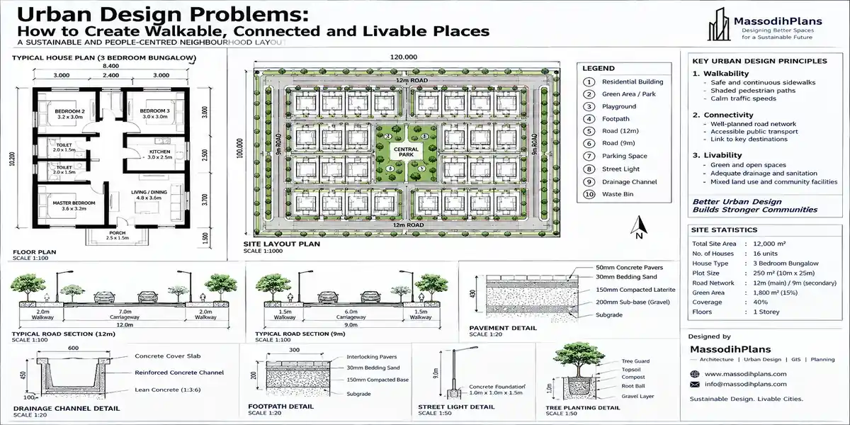
A well-designed street decides, deliberately: how wide the carriageway needs to be for the actual traffic expected (not an oversized road that just invites speeding), where drainage runs and how it’s covered so it doesn’t become a hazard or an eyesore, where pedestrians walk and whether that path is actually continuous or interrupted by every single driveway, and where trees or shade structures go, because an unshaded street in Nigeria’s climate is a street people will avoid walking on by midday regardless of how good the pavement is.
If you’re developing more than a handful of plots, get your street cross-section carriageway width, drainage, footpath, and planting strip resolved and approved before you start selling or building on individual plots. Retrofitting a street layout after buildings are already up is far more expensive, and usually means the drainage or footpath ends up compromised permanently.
Streetscape Design: The Details People Actually Notice
Streetscape design is the layer of detail sitting on top of the street’s basic geometry paving pattern, planting, street lighting, signage, seating, bollards, and how the ground floor of buildings along it looks and functions. It’s smaller-scale than street design, but it’s what people actually register when they say a street “feels nice” or “feels rough,” even when they can’t name why.
A few streetscape decisions carry outsized weight: continuous, unobstructed footpaths (a beautifully paved walkway that gets blocked every fifty metres by a parked generator or an uncovered drain might as well not exist), consistent and adequate lighting (dark stretches between working streetlights create real safety gaps, not just aesthetic ones), and visual rhythm repeated trees, consistent shopfront heights, or a consistent fence style along a stretch gives a street coherence even when the individual buildings vary.
Neighbourhood Design and Residential Neighbourhood Design: Building at a Scale People Can Actually Relate To
Whether you spell it neighbourhood or neighborhood, the design question is the same: how do you organize housing, streets, and shared spaces at a scale a resident can actually hold in their head and feel part of?
A well-designed residential neighbourhood usually has a clear centre or focal point even something modest, like a junction with a few shops and a mosque or church nearby rather than being an undifferentiated grid of identical houses with no discernible middle. It has a walkable block size (very long blocks force long detours for short trips), a mix of housing types where possible rather than one repeated unit forever, and enough internal connectivity that residents aren’t funnelled through one single choke point to reach the outside world.
Community design goes one layer further than the physical neighbourhood it’s about designing for the social life that happens inside the physical structure: shared spaces that different age groups actually use, safe routes for children between home and school, and enough small-scale commercial activity woven in that a neighbourhood has some economic life of its own instead of being purely residential and silent for most of the day.
Mixed-Use Development and Mixed-Use Planning: Why Separating Everything Backfired
For decades, conventional planning zoned cities into strict categories residential here, commercial there, industrial somewhere else entirely on the theory that separation meant order. In practice, strict separation is exactly what produces neighbourhoods where nothing is within walking distance of anything else, forcing every single errand into a car trip.
Mixed-use development brings compatible uses back together at a workable scale: shops and small offices at ground level, housing above or nearby, a clinic or school within the same walkable area. Mixed-use planning is the policy layer that makes this legal and consistent across a district updating zoning and density rules so this kind of blending is the default option, not something a developer has to fight for through endless exceptions.
Done badly, mixed-use just means a noisy bar under someone’s bedroom window. Done well, it means the right uses are matched to the right locations quieter commercial uses near housing, louder or higher-traffic uses along main roads with real thought given to noise, deliveries, and parking, not just a rule that says “you may combine uses here.”
Transit-Oriented Development: Designing Around How People Actually Move
Transit-oriented development (TOD) organizes higher density, mixed uses, and pedestrian-friendly design around a transit point a bus terminal, a train station, or in a Nigerian context, often a major bus stop or park where BRT, danfo, or keke routes converge.
The core idea is straightforward: put more people and more daily-need destinations within comfortable walking distance of the place they actually catch transport, so fewer trips need a private car at all. This matters enormously in cities where public transport exists but the land use around its stops was never designed to support it a bus stop surrounded by walled compounds and no footpath access defeats its own purpose before a single bus arrives.
Genuine TOD requires more than proximity. It needs safe pedestrian access to the transit point itself (a station surrounded by open drains and no crossing point is not actually accessible, regardless of distance), a density and use mix that generates enough daily foot traffic to justify the transit service, and parking policy that doesn’t quietly undermine the whole point by prioritizing car storage over pedestrian space right at the transit node.
Walkable Cities and Walkable Neighbourhoods: What “Walkable” Actually Requires
“Walkable” gets used loosely, so it’s worth being specific. A walkable neighbourhood needs, at minimum: destinations within a genuinely comfortable walking distance (not technically possible to walk, but pleasant enough that people choose to), a continuous and safe pedestrian path the whole way there, shade or shelter appropriate to the climate, and a reasonable expectation of safety, both from traffic and from personal security concerns.
Note that all four conditions have to be true together. A neighbourhood can have destinations within 500 metres and still be functionally unwalkable if the only route there is along an unshaded road with no footpath and open drains to dodge. This is precisely the gap between how walkable a place looks on a distance map and how walkable it actually feels on foot and it’s the gap most walkability content, written from a temperate, well-paved-sidewalk context, never has to reckon with.
Test walkability the honest way actually walk the route you’re evaluating, in the heat of the day, the way a resident would. A route that seems fine on a site plan can turn out to be genuinely unpleasant or unsafe once you’ve walked it yourself, and that gap is exactly what a plan alone will never show you.
Smart City and Smart City Planning: Technology’s Real Job
Smart city planning gets marketed as sensors, apps, and dashboards, and that framing sells more equipment than it solves problems. The actual, useful role of technology in a smart city is narrower and more useful than the marketing suggests: monitoring things that are expensive or slow to check manually (drainage capacity during heavy rainfall, traffic flow at problem junctions, streetlight faults across a large area) and making existing services more responsive rather than replacing the underlying urban design work entirely.
A smart traffic light system layered onto a badly connected street network will still produce congestion it just produces slightly better-managed congestion. A smart city strategy that skips the underlying land use, street, and public space design and jumps straight to technology is solving the wrong layer of the problem first. The technology should come after the urban design fundamentals are right, as a way to operate and maintain them better not as a substitute for getting them right in the first place.
The Layer Almost No Urban Design Article Covers: Designing for Plot-by-Plot, Incrementally Built Cities
Here’s the honest gap in almost everything written on this topic globally: it assumes a city is built by a single developer, all at once, according to one master plan. Most of urban Nigeria and most rapidly growing cities across the Global South doesn’t grow that way at all. It grows plot by plot, owner by owner, over years, often with no coordinated urban design behind it whatsoever until well after the pattern is already set.
This changes what “good urban design” has to mean in practice. A few things I’ve learned from actually working inside this reality, that a textbook written for a single master-planned suburb won’t tell you:
Design for the road reserve, even when nobody else is respecting it yet
If you’re one of the first plots developed along a stretch, holding your setback and keeping the road reserve clear isn’t just compliance it’s the only mechanism by which that street ever gets wide enough for proper access, drainage, and eventually footpaths, once the rest of the plots fill in. One plot encroaching sets a precedent every neighbour then points to.
Drainage is urban design, not an engineering afterthought
In a plot-by-plot city, stormwater management only works if each individual plot’s ground levels and drainage connect sensibly to its neighbours’ there’s no single master grading plan coordinating it. This means every individual building decision on ground level and drainage direction is, whether the owner realizes it or not, an urban design decision with consequences for everyone downstream.
Informal commerce is infrastructure, not disorder
The roadside food seller, the small kiosk, the tricycle stand outside a market conventional urban design guidelines, imported wholesale from contexts that don’t have this economy, tend to treat this activity as something to be designed away. In practice, it’s often the actual reason a street has the foot traffic and vibrancy that walkability frameworks are trying to engineer everywhere else. Good local urban design plans for space for it deliberately a widened footpath edge, a designated stall zone rather than pretending it doesn’t exist until enforcement clears it out and the street goes quiet.
Incremental legibility matters more than one-time legibility
A master-planned suburb gets its street hierarchy and landmarks all at once. A plot-by-plot area builds its legibility over years, through repeated small decisions where junctions form, which routes naturally become “the main road” because more shops locate there. Recognizing and reinforcing those emerging patterns, instead of trying to overwrite them with a grid that ignores how the area has actually already organized itself, produces far better results than starting from a blank-slate plan.
Estate-level private urban design now does real public urban design’s job
Because formal government-led urban design capacity hasn’t kept pace with growth in many Nigerian cities, private estate developers are, in practice, the ones setting street widths, public space provision, and building lines for huge portions of new urban growth. This is a genuine shift in who is actually doing urban design work on the ground and it means estate developers carry a public-interest responsibility that most of them, and most of their clients, have never been told they’re carrying.
If you’re developing an estate or a cluster of plots, treat your layout as real urban design, not just a subdivision exercise because in the absence of strong government-led planning in many areas, your street widths, public space, and drainage decisions will function as the de facto urban design standard for that neighbourhood for decades. Get it reviewed by a qualified planner before plots are sold, not after.
Common Urban Design Mistakes That Quietly Ruin Livability
- Designing the plots and buildings first, then fitting the street and drainage into whatever space is left
- Treating footpaths as optional decoration rather than a continuous, protected network
- Copying walkability or public space guidelines from a completely different climate without adapting for heat, rain, and shade
- Building a single-entrance, cul-de-sac-heavy layout that looks secure on paper but concentrates all traffic and risk onto one route
- Ignoring informal economic activity in design instead of accommodating it deliberately
- Treating “smart” technology as a fix for underlying land use and street design problems instead of a tool for managing good design better
A Practical Checklist: Is This Place Actually Well-Designed?
Whether you’re a resident sizing up a neighbourhood, a developer reviewing a layout, or a student working through a case study, these questions cut through most of the marketing language fast:
- Can I get from here to a main destination by more than one route?
- Is there a continuous, shaded, safe footpath the whole way to the nearest daily-need shop or service?
- Who is expected to be watching over the main public space, and at what times of day?
- Does the street width match the actual traffic it carries, or is it oversized in a way that just invites speeding?
- Where does stormwater go, and does this plot’s design account for its neighbours’ drainage too?
- Is there a genuine mix of uses within comfortable walking distance, or is everything single-use and car-dependent?
- Does the layout have a discernible centre or focal point, or is it an undifferentiated grid with no landmarks?
Frequently Asked Questions
What is the difference between urban design and urban planning?
Urban planning sets the broader policy, zoning, and land-use framework for an area. Urban design works within that framework at the more physical, spatial level streets, blocks, public space, and how buildings relate to them.
What are the most important urban design principles for a residential area?
Connectivity, human scale, mixed use at the right grain, and legibility matter most for daily livability a residential area can be beautiful and still fail on all four, which is usually why it feels lifeless despite good individual houses.
Why do some newly developed estates feel less lively than older, informally grown neighbourhoods?
Usually because the newer estate optimized for privacy and security in isolation high walls, single entrance, wide underused roads while the older area developed the connectivity, mixed use, and active street edges that generate genuine daily foot traffic, often without anyone formally planning for it.
Is walkability realistic in a hot, humid climate?
Yes, but only if shade, continuous safe footpaths, and nearby destinations are all designed together walkability guidance written for temperate climates that ignores shade and drainage will not transfer directly and needs local adaptation.
Do smart city technologies actually improve urban design outcomes?
They improve the management and monitoring of infrastructure that’s already well-designed. They don’t fix underlying problems in street layout, land use, or public space design those still need to be solved at the urban design level first.
Finally
Good urban design rarely announces itself. It just shows up as a street you don’t mind walking down, a neighbourhood where an errand doesn’t require a car, a public space where people actually linger instead of hurrying through. The principles behind that connectivity, mixed use, human scale, legibility, well-designed streets and public space are the same whether a place was built from one master plan or grew plot by plot over twenty years. What changes is how deliberately you have to apply them when nobody’s doing it for you at the city level.
If you’re planning a development and want your layout designed with these principles built in from the start, our Services page outlines how we approach site and layout planning alongside individual building design. Browse our Plans Library for house designs built to sit well within a properly planned neighbourhood, or visit Plan School for more on how planning and approval actually works before you commit to a layout. You can also explore more planning and design guides on our Homepage. You can also read about:
- Town Planning: How Urban Development, Land Use and Planning Permission Work
- Mortgage Home Finance: How to Calculate Rates, Payments and Home Loan Costs
- Property Management: Complete Guide to Managing Rentals and Property Safely
- Land and Plot Guide: How to Choose, Measure, Value and Register Property
- How to Create a Site Plan: Site Analysis, Layout and Development Guide Today
Author
Massodih Okon is a Nigerian built-environment professional with academic and professional experience in urban and regional planning, geography, architectural design, Landscape Design, GIS and land development.
He holds a Master’s degree in Urban and Regional Planning from the University of Uyo and a first degree in Geography and Regional Planning.
Through MassodihPlans, he publishes practical guides on Nigerian house plans, building design, physical planning, site planning, development approval and residential construction. Read the full author profile →