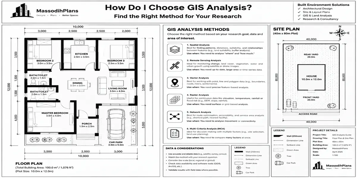
How Do I Choose GIS Analysis? Find the Right Method for Your Research
Choosing the right GIS analysis starts with your research question, not the software or the method you saw in another study. Before opening QGIS or ArcGIS, ask yourself: What exactly am I trying to find out? If you want to know where something is located, you may need mapping or spatial distribution analysis. And if you want to understand how close, far, or accessible things are, proximity, buffer, or network analysis may be appropriate. If you want to discover patterns or concentrations, spatial statistics such as hotspot or cluster analysis could be the answer. And if your goal is to determine which locations are most suitable for something, you are probably looking at suitability or multi-criteria analysis.
The key is to match the question, data, and expected result. Your research question tells you what you need to investigate, your available spatial data determines what you can realistically analyse, and your expected outcome helps you select the technique that produces meaningful evidence. This is why two researchers studying seemingly similar topics can legitimately use different GIS methods.
So, don’t choose a GIS analysis because it looks sophisticated, because another researcher used it, or because your supervisor mentioned it. Choose it because it directly answers the question your research is asking. Once you understand that principle, selecting a GIS method becomes much less intimidating. You stop asking, “Which analysis should I use?” and start asking the much better question: “Which analysis will best answer my research question?”
First, Stop Asking “Which GIS Analysis Is Best?”
This is the wrong question, and it’s the reason most people stay stuck. There is no “best” GIS analysis method in the abstract the same way there’s no “best” tool in a toolbox until you know whether you’re hammering a nail or tightening a bolt. Buffer analysis isn’t superior to overlay analysis. Interpolation isn’t more advanced than network analysis. They solve different problems, full stop.
The real question you should be asking is: “What does my research question actually require me to find out?” Once you can answer that clearly, the method almost chooses itself. So before we even talk about specific techniques, we need to fix your research question first because a vague question guarantees a vague (and often wrong) method choice.
Step 1: Turn Your Research Question Into a Spatial Question
Here’s a test I give my students. Take your research question and ask: if I removed every geographic or locational word from this question, would it still make sense as ordinary research? If yes, you might not actually need GIS at all you might just need statistics.
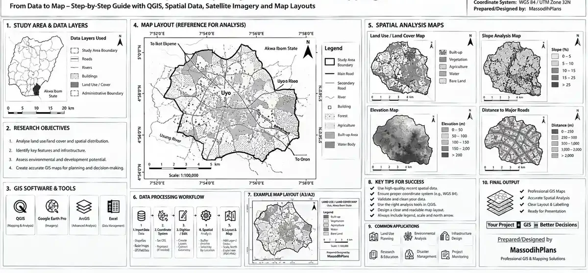
For example: “What factors influence housing deprivation in Uyo?” is a question that becomes genuinely spatial only when you ask it properly: “Where, geographically, is housing deprivation concentrated in Uyo, and what spatial factors distance to infrastructure, drainage pattern, elevation explain that pattern?” See the difference? The second version forces you toward specific GIS methods (hotspot analysis, overlay, proximity analysis), while the first could be answered with a plain regression table and no map at all.
Write your question down. Underline every word in it that implies location, distance, pattern, proximity, or change over space. Those underlined words are your clue to which method family you need.
If you can’t underline at least two spatial words in your research question, go back to your supervisor before you touch any software. A weak spatial question wastes months of analysis on a method that was never going to answer what you’re actually asking.
Step 2: Match Your Question to a Method Family, Not a Single Tool
Once your question is properly spatial, group it into one of these families. This is the layer most GIS guides skip entirely they jump straight into listing techniques without ever showing you how a real question maps onto a real method.
If your question is about “where is X located, and is that pattern random or meaningful?” you need pattern and cluster analysis: hotspot analysis (Getis-Ord Gi*), kernel density estimation, or spatial autocorrelation (Moran’s I). This is the family for questions like crime distribution, disease outbreak clustering, or where informal settlements concentrate.
If your question is about “which locations are suitable for X, given multiple conditions?” you need overlay and multi-criteria suitability analysis, usually built with weighted overlay or AHP (Analytic Hierarchy Process) combined in GIS. This is the family for site selection questions and it’s the one I personally use most, because it’s exactly how we identify suitable land for residential development on small plots, which I’ll come back to shortly.
If your question is about “how has this changed over time?” you need change detection analysis, comparing classified satellite imagery or land use maps across two or more dates. This is the family for urban sprawl, deforestation, or coastal erosion questions.
If your question is about “how does distance or accessibility affect X?” you need proximity and network analysis: buffer zones, service area analysis, or shortest-path routing. This is the family for questions about access to healthcare, schools, or how far people travel to markets.
what is the value of X at locations where I have no data?
If your question is about “what is the value of X at locations where I have no data?” you need spatial interpolation: IDW, kriging, or spline methods. This is the family for rainfall estimation, soil property mapping, or pollution concentration modelling.
If your question is about “how do multiple spatial variables jointly predict or explain X?” you need spatial statistics and regression: geographically weighted regression (GWR), spatial regression models, or logistic regression with spatial covariates. This is the family for explaining why something happens where it happens, not just describing that it does.
Find your question in that list. That’s not a suggestion that’s genuinely the fastest route to a defensible method, because it means your method choice is traceable directly back to your question, which is exactly what an external examiner checks first.
Before You Build Your Methodology Chapter: Never pick a method because it’s trending in recent papers, or because your friend used it and passed. A method chosen for the wrong reason is painfully obvious to an examiner, and it’s one of the fastest ways to get sent back for correction not because your software work was bad, but because the whole chapter doesn’t logically hang together.
Step 3: Check Your Data Before You Commit to a Method
This is the step everybody skips, and it’s where projects quietly fall apart three months in. A method can be theoretically perfect for your question and still be completely unusable if the data it requires doesn’t exist, isn’t accessible, or isn’t fine-grained enough for your study area.
Before locking in your method, confirm:
- Does the data actually exist for your study area, at the resolution/scale you need, and can you legally access it?
- Is it current enough to answer your question, or are you about to build an entire chapter on a five-year-old land use map?
- Do you have the attribute data (not just the spatial geometry) needed to run the analysis a shapefile of buildings is useless for suitability analysis if it has no attribute fields for flood risk, soil type, or slope?
- If you need to collect primary data yourself (GPS points, surveys, drone imagery), is that realistically achievable in your research timeline and budget?
I tell my students this bluntly: your methodology should be built around the best method your actual, obtainable data supports not the best method in theory that depends on data you’ll never get your hands on in time. A technically “better” method you can’t execute is worse, in practice, than a simpler method you can execute properly.
Haha, and this is where I always remind my students make I yarn una small joke make e click well. Some of una dey choose “advanced geospatial machine learning model” for project wey una no even get complete rainfall data for one year! Na so some people dey carry Ferrari engine come put for bicycle the engine fine well well, but the bicycle no fit carry am reach anywhere. Match your method to what your data can actually carry, abeg.
Step 4: Match the Method to Your Software and Your Skill Level Realistically
Different GIS software genuinely suit different methods and different skill levels, and pretending this doesn’t matter is how people get stuck for months.
QGIS is free, open-source, and increasingly capable of almost everything ArcGIS does for standard academic research overlay, interpolation, basic network analysis, suitability mapping. For students, especially outside well-funded institutions, this is usually the realistic default, and examiners rarely penalize you for using it instead of paid software.
ArcGIS Pro / ArcMap remains the industry standard in many government and consulting environments, with a gentler learning curve for certain advanced tools and stronger documentation, but it requires a paid license that many students and independent researchers simply don’t have.
R (with spatial packages like sf, spdep, raster) or Python (geopandas, rasterio) is increasingly expected for advanced spatial statistics geographically weighted regression, custom spatial models because neither QGIS nor ArcGIS’s point-and-click interface handles some advanced statistical methods well out of the box.
If you’re choosing between two methods of roughly equal suitability for your question, and one is achievable in software you already know while the other requires three additional months learning new software from scratch, be honest about your timeline. A well-executed simpler method beats a half-finished advanced one every single time at defense.
Step 5: Think Through How You’ll Defend This Choice, Before You Even Start
Here’s something almost no GIS guide tells you: choosing a method isn’t just about getting results it’s about being able to stand in front of an examiner, a supervisor, or a client and explain, in one or two confident sentences, why this method and not another. If you can’t do that right now, on paper, before you’ve even opened the software, that’s a sign your method choice isn’t solid yet.
Practice saying it out loud: “I chose weighted overlay suitability analysis because my research question is about identifying the most suitable locations for X, given multiple competing criteria, and this method allows me to combine those criteria transparently and show my weighting logic unlike a purely statistical model, which wouldn’t let me visualize suitable zones directly.” If you can say something like that confidently about your own choice, you’re ready. If you’re fumbling, go back to Step 1 your question and method still aren’t properly aligned.
Write your method justification paragraph before you run a single analysis, not after. If you can’t justify it in writing first, running the analysis won’t fix that gap it’ll just hide it until your defense, when it’s far more expensive to discover.
Common Mistakes That Sink a GIS Methodology Chapter
Choosing a method because a published paper used it, without checking whether that paper’s research question actually matches yours
Ignoring data resolution mismatches combining a coarse national dataset with a fine-scale local dataset and treating the output as equally reliable everywhere
Skipping a proper literature-grounded justification for the method, leaving the choice looking arbitrary to an examiner
Overcomplicating the method to sound impressive, when a simpler, properly executed technique would answer the question just as well and with fewer failure points
Not testing the workflow on a small sample first, then discovering a fatal data gap halfway through the full analysis
And honestly, make I yarn una the second joke small, because I see this one too often. Some students go dey add “AI” and “machine learning” for their proposal just to impress panel, meanwhile dem never even sort their shapefile projection system half their layers dey show for Atlantic Ocean instead of their actual study area! Na so one man wan build mansion, but him never even fix him foundation, him dey already choose chandelier for sitting room. Abeg, sort your projection and coordinate system first, before you go chase big big method name.
How This Connects to Real Building and Site Selection Work (Not Just Academic Theory)
Here’s where I want to bring this back to something practical, because this is genuinely where GIS analysis choice stops being an abstract academic exercise and becomes something that shapes real buildings, real plots, and real money. This is also the layer you won’t find on a typical GIS methodology blog, because most of them are written by people who’ve never had to apply this choice to an actual construction project.
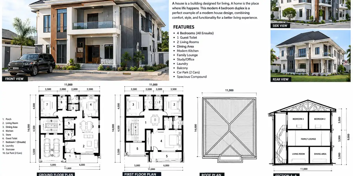
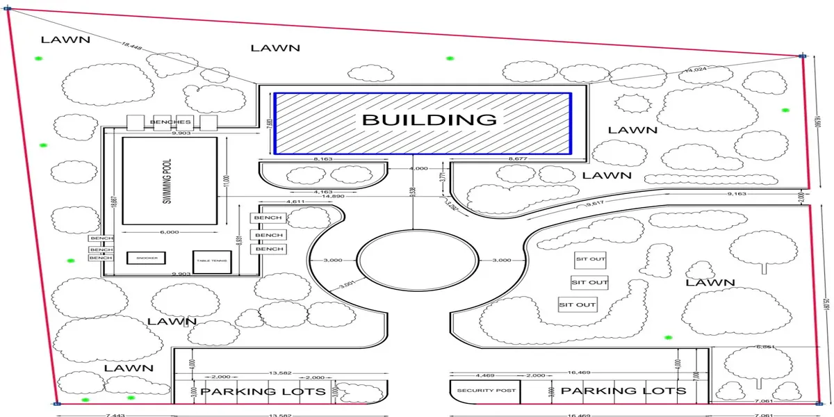
When a client brings me a small plot of land and asks whether it’s genuinely suitable for the house they’re planning, I’m effectively running a compact version of exactly the suitability analysis (overlay/multi-criteria) method family described above just at a much smaller, site-specific scale than a typical thesis study area. I’m layering soil condition, drainage pattern, elevation relative to surrounding plots, proximity to existing infrastructure, and setback/zoning constraints to determine the realistically buildable area and the right foundation approach before a single architectural drawing is made.
The exact same method-selection logic in this article define the real question first, pick the method family that matches it, check whether your data actually exists and is good enough, then be able to defend the choice applies whether you’re writing a dissertation on urban flood risk or deciding where on a 450 sqm Lagos plot your foundation should actually sit relative to the drainage path. If you’re planning to build on a small plot anywhere in Nigeria and you want that decision grounded in this kind of actual spatial analysis rather than guesswork, that’s precisely the kind of site-level thinking behind the guides in our [Plans Library] and the professional support available through our [Services] page.
A Quick Global Note: Does This Change If You’re Researching Outside Nigeria?
I get this question a lot from readers in the US, UK, Germany, UAE, Canada, Australia, Singapore, and a good number from Iceland, Luxembourg, Switzerland, and Qatar too does the method-choosing logic change by country? Mostly, no the five-step process above is genuinely universal. What does change by country is Step 3 (data availability).
In the US, UK, Germany, Canada, and Australia, open government geospatial data portals are generally rich and well-maintained, so data scarcity is rarely your limiting factor your limiting factor is usually processing time and your own GIS skill level. And in Singapore and the UAE, high-resolution government data exists but can require formal access requests or institutional affiliation, so build extra time into your timeline for that approval process. In smaller or less digitally mapped contexts including much of Nigeria outside major cities, and genuinely in places like Iceland or Luxembourg too, where detailed open datasets can be surprisingly limited for very localized small-area studies you may need to combine global datasets (like satellite imagery or OpenStreetMap) with your own primary field data collection to get a workable dataset at all. Build that reality into your timeline from day one, regardless of which country you’re researching in.
Frequently Asked Questions
How do I know if my research even needs GIS, or just regular statistics?
If removing the locational/geographic element from your question leaves it still making complete sense, you likely need statistics, not GIS. If location, distance, or spatial pattern is central to the question itself, you need GIS.
Can I use more than one GIS analysis method in a single research project?
Yes, and in many strong dissertations you should for example, change detection to show how land use shifted over time, followed by suitability analysis to identify where future development should go. Just make sure each method is tied to a distinct, clearly stated sub-question, not thrown in just to look thorough.
Is QGIS acceptable for academic research, or do I need ArcGIS?
QGIS is widely accepted in academic research globally and can execute the vast majority of standard methods used in theses and journal articles. Choose ArcGIS only if your specific method genuinely requires a tool QGIS doesn’t handle well, or your institution mandates it.
What’s the biggest sign that I’ve chosen the wrong GIS method?
You cannot clearly explain, in one or two sentences, why this method specifically answers your research question better than an obvious alternative. If you’re stuck explaining it, the choice likely isn’t solid yet.
How early in my research should I finalize my GIS method?
Before you collect or source your final dataset, not after. Your data requirements are dictated by your method, so finalizing the method late almost always forces a rushed, poorly match data scramble afterward.
One Last Joke Before You Go (Because You’ve Earned It)
Make I drop the last one for una before I round up, because if you don reach this point for the article, you don already suffer with una supervisor small small. Some of una go dey do correction for your GIS chapter, supervisor go talk say “your method no clear,” you go just change the font and margin, think say na so dem go accept am! My people, na your method dem dey query, not your Times New Roman. Fix the actual thinking, not the formatting the formatting no fit save a method wey never answer the question.
Finally
Choosing the right GIS analysis isn’t about memorizing a list of techniques and picking the one that sounds most advance it’s about reading your own research question honestly, matching it to a method family that was actually built to answer that kind of question, confirming your data can genuinely support it, and being able to defend that chain of reasoning out loud before you ever touch the software. Get that sequence right, and the rest the actual button-clicking in QGIS or ArcGIS becomes the easy part.
If you’re working through a GIS-based dissertation or project and want this kind of grounded, practitioner-level guidance applied to your specific topic, or if this spatial thinking has you reconsidering how you’d evaluate a piece of land for building, feel free to explore our Services page for direct support, or browse Plan School for more practitioner guides that connect planning theory to real-world application. You’ll also find more articles like this on our Homepage, and if land and site suitability is genuinely your next step, our Plans Library has house plans designed with exactly this kind of site-level spatial thinking already built in.
- How Do I Do GIS Analysis for My Thesis? A Real Step-by-Step Guide
- How Do I Get Building Approval? Steps, Documents & Fees in Nigeria
- How Many Bedrooms Can Fit on My Plot? Nigeria Plot Size & Layout Guide
- Where Should My Staircase Go? Best Position in Nigerian House Plans
- How Do I Do GIS Analysis for My Thesis? A Real Step-by-Step Guide
Author
Massodih Okon is a Nigerian built-environment professional with academic and professional experience in urban and regional planning, geography, architectural design, Landscape Design, GIS and land development.
He holds a Master’s degree in Urban and Regional Planning from the University of Uyo and a first degree in Geography and Regional Planning.
Through MassodihPlans, he publishes practical guides on Nigerian house plans, building design, physical planning, site planning, development approval and residential construction. Read the full author profile →