Why Most Cities Fail And How the FutureGrid Blueprint Changes Everything
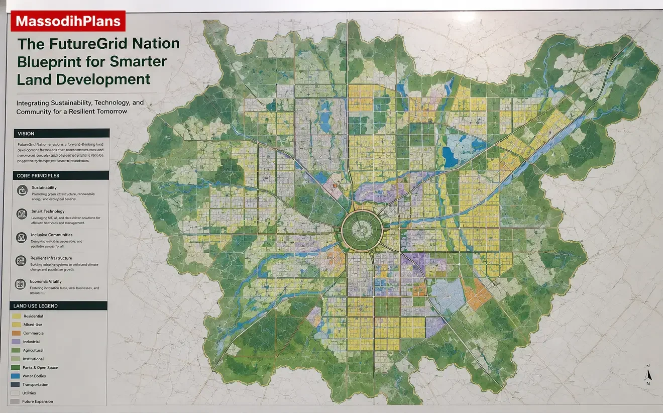
Proposed FutureGrid Nation Blueprint for Smarter Land Development
Urban growth is not the problem. Unplanned urban growth is the crisis. Across Africa, Asia, Latin America, and the wider developing world, cities are expanding faster than any planning office, utility provider, or road engineer can keep pace with. The consequence is predictable, clogged roads, flooded settlements, collapsing drainage, failed infrastructure, and land disputes that last decades. The FutureGrid Nation Blueprint was conceived as a direct answer to this reality.
I have spent years studying physical development plans, master plans, layout plans, and urban growth frameworks across multiple jurisdictions. What I consistently observe is not a shortage of land. It is a shortage of structured, intelligent, and implementable planning frameworks that translate ambition into liveable, investable, and governable urban environments. That is precisely what the FutureGrid Nation Blueprint delivers.
Whether you are a student planner, lisence planner, land developer purchasing a large tract in a peri-urban area, a town planner preparing a statutory development plan, a government official approving layout schemes, or a real estate investor evaluating a new estate concept, this blueprint speaks directly to your work. It integrates land use planning, zoning hierarchy, transportation frameworks, drainage strategy, GIS mapping, development phasing, and community design into one coherent, practical planning system.
This is not academic theory. It is a working framework built on field realities, planning practice observations, and global master planning principles that apply wherever cities grow fast and planning capacity struggles to keep up.
What Is the FutureGrid Nation Blueprint?
The FutureGrid Nation Blueprint is a structured master planning and physical development framework designed to guide smarter land development across urban, peri-urban, and emerging settlement environments. It integrates all the core disciplines of physical planning from land use allocation and zoning hierarchy, to circulation design, infrastructure sequencing, environmental management, and development control into a single coordinated planning system.
At its core, the blueprint operates on three governing principles:
Land efficiency: The plan allocates every square metre of developable land purposefully, without wastage or under-specification.
Infrastructure readiness: The plan does not open any residential or commercial zone for development until the supporting infrastructure, including roads, drainage, water, and power corridors, is installed or scheduled for imminent delivery.
Community functionality: The plan designs every neighbourhood unit to function as a complete community, with access to services, open space, circulation, and civic facilities within a comfortable walking or cycling radius.
The blueprint draws heavily from the MassodihPlans Plans Library, which archives physical development plans, layout schemes, and master plan frameworks across different scales and geographies. It also incorporates global planning standards endorsed by organisations such as UN-Habitat, whose Urban Planning guidelines provide authoritative frameworks for sustainable urban expansion in developing regions.
Expert Planning Note: A master plan is not a final design. It is a strategic spatial framework that guides decisions over time. The FutureGrid Blueprint is designed to be adaptive, meaning it anticipates growth, allows phased evolution, and accommodates corrections without requiring a complete redesign.
Project Overview and Planning Objectives
The FutureGrid Nation Blueprint is scalable. It can be applied to a 50-hectare peri-urban layout, a 500-hectare new town extension, or a regional master plan covering multiple communities. The planning objectives remain consistent regardless of scale:
- Establish a clear and enforceable land use framework that separates incompatible activities while promoting healthy mixed-use integration where appropriate.
- Design a road and circulation hierarchy that supports current population movement needs while anticipating a 20-year growth projection.
- Create a drainage and flood management strategy that functions under extreme rainfall events without requiring constant intervention.
- Phase infrastructure delivery to align with funding realities, ensuring that development proceeds in a structured, investment-backed sequence.
- Protect environmental resources watercourses, flood plains, ecologically sensitive areas, and existing vegetation through formal buffer zones and conservation allocations.
- Provide sufficient public open space, institutional land, and community facilities to sustain a functional, healthy urban environment.
- Establish development control standards that prevent plot encroachment, setback violations, and infrastructure overloading.
These objectives are not aspirational statements. They are measurable planning outcomes that can be tracked through GIS monitoring, development permit records, and periodic plan reviews. Learn more about how these objectives translate into real site plans by exploring the MassodihPlans Plan School, which provides step-by-step planning education for practitioners at every level.
Site Analysis and Existing Land Use Assessment
No credible master plan begins without a rigorous site analysis. The FutureGrid Blueprint requires a comprehensive examination of the existing landscape before a single line of proposed development is drawn. This analysis covers physical conditions, existing patterns of use, and infrastructure context.
Physical Site Analysis Components
- Topography and slope analysis: Slope gradients above 15% are generally excluded from intensive development and reserved for open space or low-impact uses. GIS-generated digital elevation models (DEM) provide the most reliable slope analysis at the planning scale.
- Drainage pattern identification: Natural watercourses, seasonal drainage lines, and flood-prone areas are mapped and protected with minimum 30-metre buffer setbacks from channel edges.
- Soil and ground conditions: Expansive clay soils, organic soils, and areas of high water table require engineering interventions that affect both infrastructure cost and development feasibility.
- Vegetation and ecological assets: Significant tree stands, riparian vegetation, and ecologically sensitive habitats are mapped for protection or managed integration into the green infrastructure framework.
- Existing settlement patterns: Informal settlements, agricultural operations, and existing access tracks inform the layout of proposed streets and help avoid costly displacement conflicts.
GIS Integration in Site Analysis
GIS mapping is not optional in a serious master planning exercise. The FutureGrid Blueprint uses GIS at every stage, from base mapping and constraint analysis, to land use allocation, infrastructure routing, and plan monitoring. GIS enables planners to overlay multiple datasets simultaneously; soil, slope, drainage, vegetation, cadastral boundaries, utilities and produce composite suitability maps that identify where development should go, where it should not, and where it requires mitigation.
At the layout planning scale, GIS supports precise plot dimensioning, road centreline alignment, setback calculation, and area tabulation. It also enables the production of zoning maps, land use plans, and phasing diagrams that communicate planning decisions clearly to decision-makers, developers, and communities.
Planning Tip: When GIS data is unavailable or incomplete, start with drone photogrammetry for sub-metre topographic mapping. Even a basic drone survey of a 100-hectare site produces a more accurate planning base than a decade-old hand-drawn survey sheet.
Proposed Land Use Framework and Colour Coding Standard
The FutureGrid Nation Blueprint adopts a universal land use colour coding standard to ensure consistency across plan drawings, zoning maps, GIS outputs, and planning reports. This standard aligns with internationally recognised physical planning conventions and ensures that any planner, developer, or government official reviewing the plan can interpret the land use categories instantly and without ambiguity.
Land Use Colour Coding Standard:
- Residential activities — Yellow
- Commercial, shopping, or business activities — Red
- Industrial and manufacturing activities — Purple
- Institutional and public infrastructure uses — Blue
- Transportation and circulation systems — Gray
- Mass assembly and civic gathering spaces — Dark Slate Gray
- Recreational and leisure uses — Light Green
- Natural resource and ecological conservation uses — Forest Green
- Undeveloped or unclassified land — White
Typical Land Use Distribution at the Neighbourhood Scale
| Land Use Category | Colour | Typical Allocation | Planning Rationale |
|---|---|---|---|
| Residential | Yellow | 45 – 55% | Primary land use; density calibrated to population projection |
| Roads and Circulation | Gray | 18 – 25% | Includes road reserves, footpaths, and service lanes |
| Commercial | Red | 8 – 12% | Neighbourhood retail, mixed-use frontages, service commercial |
| Institutional | Blue | 6 – 10% | Schools, clinics, government offices, places of worship |
| Recreational | Light Green | 5 – 8% | Parks, playgrounds, sports grounds, neighbourhood green space |
| Conservation / Buffer | Forest Green | 3 – 6% | Riparian buffers, ecological corridors, protected vegetation |
| Industrial / Light Industrial | Purple | 2 – 5% | Cottage industry, artisan workshops, light manufacturing zones |
| Civic / Mass Assembly | Dark Slate Gray | 1 – 3% | Community centres, town halls, cultural facilities |
These allocations are indicative. The actual percentages for any specific plan area depend on the population projection, density targets, existing constraints, and the urban growth context of the locality.
Zoning Hierarchy and Development Control Framework
Zoning is the legal and spatial mechanism through which a master plan becomes enforceable. Without a clearly articulated zoning hierarchy, a land use plan is merely a diagram. The FutureGrid Blueprint establishes zoning at three hierarchical levels.
Primary Zones
Primary zones define the broad land use character of each part of the plan area, Residential, Commercial, Industrial, Institutional, Recreational, and Conservation. These zones are shown on the statutory zoning map and are the foundation of all development control decisions.
Secondary Zones (Sub-Zones)
Within each primary zone, secondary zones define the intensity and character of permitted development. Within the Residential primary zone, sub-zones include:
- R1 — Low Density Residential: Detached single-family dwellings on plots of 450 sqm and above. Maximum site coverage of 40%.
- R2 — Medium Density Residential: Semi-detached and terrace dwellings on plots from 250 sqm. Maximum site coverage of 50%.
- R3 — High Density Residential: Flats, apartments, and multi-family units. Plot ratio of up to 2.0. Mandatory parking provisions apply.
Overlay Zones
Overlay zones apply additional planning requirements on top of primary and secondary zoning. Common overlays in the FutureGrid Blueprint include flood hazard overlays, heritage conservation overlays, airport noise contours, and high-voltage power line corridor restrictions.
Planning Mistake to Avoid: Ignoring overlay zones when preparing subdivision layouts or approving building permits is one of the most common and costly planning errors in developing-country contexts. A residential zone within a flood hazard overlay requires engineering flood mitigation as a condition of development approval. Skipping this step does not eliminate the flood risk, it transfers it to the residents.
Circulation System and Road Hierarchy
The circulation framework is the most consequential spatial decision in any master plan. Roads consume between 18 and 25 percent of total plan area. They shape plot configurations, drainage alignments, utility routing, and the entire urban character of the development.
FutureGrid Road Classification System
| Road Class | Reserve Width | Carriageway | Design Speed | Function |
|---|---|---|---|---|
| Expressway / Arterial | 60 – 90m | 4 – 6 lanes | 80 – 120 km/h | Regional movement; connects to national road network |
| Primary Collector | 30 – 45m | 4 lanes (dual 2) | 60 – 80 km/h | Connects neighbourhood clusters; commercial frontage eligible |
| Secondary Collector | 18 – 24m | 2 lanes | 40 – 60 km/h | Internal neighbourhood distribution; school and park access |
| Local Access Road | 10 – 15m | 2 lanes | 20 – 40 km/h | Plot access; residential streets |
| Cul-de-sac / Court | 8 – 12m | Single lane | 15 – 20 km/h | Terminal residential courts; maximum 20 plots served |
| Pedestrian and Cycle Path | 3 – 5m | 2 – 3m shared path | Walking / cycling | Green linkages, school routes, park connections |
In tropical and subtropical developing country contexts, road reserve widths also serve a critical secondary function they accommodate drainage channels, utility corridors, and street tree planting within their unpaved shoulders. A 15-metre local road reserve in a Nigerian residential estate, for example, typically accommodates a 7-metre carriageway, two 2-metre footpaths, and two 2-metre open drain reserves on each side. This multi-functional use of the road reserve is essential to making infrastructure work within the fiscal constraints of most developing-country developments.
Traffic Calming and Pedestrian Safety
The FutureGrid Blueprint mandates traffic calming devices at all school zones, park entries, and residential street junctions. Speed humps, raised pedestrian crossings, and entry threshold treatments are specified at the layout planning stage not retrofitted after accidents occur.
Plot Arrangements, Setbacks, and Development Standards
Plot arrangements within the FutureGrid Blueprint follow a hierarchy of density, orientation, and servicing logic. The arrangement of plots directly determines infrastructure efficiency, drainage performance, air circulation, solar access, and the quality of daily life for residents.
Setback Standards
| Development Zone | Front Setback | Rear Setback | Side Setback | Max Site Coverage |
|---|---|---|---|---|
| R1 Low Density | 6m | 6m | 2m each side | 40% |
| R2 Medium Density | 4.5m | 3m | 1.5m (one side nil allowed) | 50% |
| R3 High Density | 3m | 2m | Nil (party wall permissible) | 60% (FAR 2.0) |
| Commercial | 0 – 3m (active frontage) | 3m | Nil where fire code permits | 70% (FAR 3.0) |
| Industrial | 10m | 8m | 6m each side | 50% |
| Institutional | 6m | 6m | 3m each side | 40% |
Setbacks serve multiple simultaneous planning functions, they provide daylight and ventilation between buildings, create landscaping opportunities, buffer structural encroachment onto road reserves and utility easements, and in flood-prone areas, reduce impervious coverage to allow stormwater infiltration.
Find detailed plot arrangement standards and layout plan examples in the Plans Library section.
Compact Development and Land Optimisation
The FutureGrid Blueprint embraces compact development principles without sacrificing liveability. Compact urbanism means achieving higher population densities through smaller, better-designed plots, mixed-use ground floors, multi-storey development in commercial and high-density residential zones, and the elimination of oversized road reserves that consume developable land without adding proportionate value.
“The most expensive land in any layout scheme is the land wasted on oversized roads, unnecessary turning circles, and unserviced open spaces that become dumping grounds within five years of occupation. Compact, purposeful design pays dividends in every dimension financial, social, and environmental.”
Open Space Allocation and Green Infrastructure
Open space is not leftover land. In the FutureGrid Blueprint, green infrastructure is planned with the same rigour as roads and utilities.
Open Space Hierarchy
- Neighbourhood Parks (0.5 – 2 ha): Provided within 400m walking distance of all residential plots. Minimum width of 30m. Equipped with seating, children’s play equipment, and shade trees. Not less than 2% of net residential area.
- District Recreation Grounds (2 – 10 ha): Serving multiple neighbourhoods. Includes sports pitches, jogging tracks, and community pavilions. Located on collector road frontages for accessibility.
- Linear Green Corridors: Riparian buffers, drainage reserves, and utility easements converted into planted linear parks. These provide ecological connectivity, flood attenuation, and pedestrian linkage simultaneously.
- Urban Squares and Civic Spaces: Located at commercial and institutional nodes. Hardscaped but planted. Serve as gathering spaces, market venues, and community focal points.
The FutureGrid Blueprint targets a minimum of 9 square metres of usable public open space per resident consistent with WHO urban green space recommendations.
Infrastructure Planning: Roads, Utilities, and Services
Infrastructure planning in the FutureGrid Blueprint is coordinated, not sequential. One of the most persistent implementation failures in developing-country land development is the disconnected delivery of infrastructure components, roads without drainage, electricity without utility easements, and water reticulation without reference to road alignments.
Utilities Planning Principles
- All utility corridors, water mains, sewer lines, low-voltage electricity, telecommunications conduits are routed within road reserves or dedicated utility easements. No utility corridor crosses private plots except with registered easements on title.
- Underground utility routing is specified on the infrastructure plan, showing minimum burial depths, separation distances between different utility types, and marker post requirements.
- Transformer substations, water pump stations, and telecommunications nodes are allocated specific institutional plots within the layout not sited on road reserves or squeezed into corners of recreational land.
- Waste collection points are located within 150m of every residential plot, accessible by collection vehicle, and designed with screening walls and drainage to manage leachate and odour.
Power Infrastructure Realities in Emerging Urban Areas
Grid electricity is unreliable in many developing-country contexts. Substations are frequently overloaded. Transmission losses are high. The FutureGrid Blueprint responds to this by reserving adequate plot area for on-site renewable energy systems solar panel mounting space on institutional and commercial rooftops, solar street lighting easements within road reserves, and community battery storage facilities where grid stability is chronically poor.
Drainage Strategy and Flood Control
Drainage failure is the single most visible infrastructure crisis in developing-country urban areas. Layouts where drainage was an afterthought where roads were designed without channel provisions, where natural drainage lines were obstructed by buildings consistently produce the same catastrophic outcomes.
FutureGrid Drainage Design Principles
- Catchment-based design: Drainage catchments are delineated from GIS topographic data before road alignments are finalised. Road gradients are designed to direct surface runoff toward drainage channels, not away from them.
- Two-tier drainage system: A minor drainage system handles regular storm events (up to the 10-year return period event). A major drainage system, using road reserves, drainage reserves, and open green corridors handles extreme events up to the 100-year return period without causing property flooding.
- Vegetated swales and retention basins: Where land area permits, vegetated drainage swales are preferred over concrete-lined channels. They reduce peak flow velocities, improve water quality, provide habitat value, and reduce maintenance costs.
- No development in flood hazard zones: All areas within the 1-in-100-year flood extent are excluded from residential and commercial development and allocated as conservation buffers or passive recreational land.
- Permeable paving in low-traffic areas: Residential courtyards, parking areas, and pedestrian paths in low-density zones use permeable paving to reduce surface runoff and increase stormwater infiltration.
Critical Implementation Warning: Drainage channels that are correctly designed at the engineering stage but not maintained after handover to the local government authority will fail within five to seven years of completion. The FutureGrid Blueprint therefore includes a maintenance management plan as a mandatory component of the development approval package. A drainage system without a maintenance strategy is a deferred flood disaster.
Environmental Management and Climate Responsiveness
Climate responsive planning is no longer optional. In sub-Saharan Africa alone, average temperatures are projected to rise 1.5 to 3 degrees Celsius above pre-industrial levels within the planning horizon of most master plans being prepared today. The FutureGrid Blueprint embeds climate resilience into every layer of the planning framework.
Urban Heat Island Mitigation
- Street tree planting at minimum 10-metre spacing along all collector and arterial roads. Tree species selected for canopy density, drought tolerance, and root characteristics compatible with underground utilities.
- Green-roof requirements for all flat-roofed commercial and institutional buildings above 500 sqm footprint.
- Mandatory cool-roof specifications (minimum solar reflectance of 0.65) for industrial buildings and large commercial warehouses.
- Minimum 30% soft landscaping coverage within all non-residential plots.
Environmental Impact Integration
The blueprint requires a preliminary environmental assessment for all plan areas above 10 hectares before the layout plan is finalised. For areas above 100 hectares or those adjacent to watercourses, wetlands, or protected ecological zones, a full Environmental Impact Assessment is mandatory.
For guidance on the environmental planning process, the Plan School section provides detailed tutorials on environmental planning integration.
Transportation Integration and Mixed-Use Planning
Transportation does not begin and end with road design. The FutureGrid Blueprint approaches transportation as an integrated system that connects land use decisions with movement patterns. The foundational principle is this: the shorter the trip, the smaller the infrastructure investment required.
Transit-Oriented Clusters
Along primary collector roads and at the intersection of collector roads with the arterial network, the blueprint designates transit-oriented cluster zones, higher-density mixed-use precincts designed around bus stops, taxi ranks, and future rapid transit corridors. These clusters concentrate commercial activity, employment, and higher-density residential development at the points of highest accessibility, reducing the need for private vehicle trips.
Parking and Vehicular Management
The FutureGrid Blueprint specifies minimum parking requirements by land use type as a practical management tool that prevents on-street parking from consuming road capacity and creating pedestrian hazards. Shared parking strategies are promoted in commercial and mixed-use zones, where car parks serving retail uses by day can serve evening entertainment and residential overflow uses at night.
Population Projections and Density Planning
Population projection is the quantitative foundation of every spatial decision in the FutureGrid Blueprint. Without a defensible population projection, there is no basis for calculating residential land requirements, infrastructure capacity, school provisions, clinic catchments, or road design volumes.
Population Projection Methodology
- Base data: National census data disaggregated to the local government or enumeration area level, supplemented by local population surveys where the census is more than five years old.
- Growth rate methodology: A compound annual growth rate is applied separately to natural population increase and in-migration, with the in-migration component calibrated against observed urban growth rates for comparable settlements in the region.
- Planning horizon: A 20-year projection horizon is standard for master plans. A 10-year projection is used for layout plans and infrastructure design.
- Density assumptions: Average household size and persons-per-hectare benchmarks are derived from local survey data rather than national averages, which frequently mask significant local variation.
Development Phases and Implementation Strategy
A master plan implemented all at once is not a master plan; it is a construction contract. The FutureGrid Blueprint supports phased implementation and aligns with the realistic pace of infrastructure delivery, market absorption, and public investment capacity
Phase 1 — Years 0 to 3 Primary infrastructure installation: trunk roads, main drainage channels, water mains, power backbone. Release of Phase 1 residential plots only. Establishment of community anchor, school, health facility, civic space.
Phase 2 — Years 3 to 8 Secondary road completion. Commercial corridor activation. Secondary school and district park delivery. Higher-density residential zones opened as Phase 1 approaches 70% occupancy.
Phase 3 — Years 8 to 15 Transit-oriented cluster development. Industrial or light industrial zone activation. Mixed-use intensification along collector roads. Green infrastructure completion.
Phase 4 — Years 15 to 20 Future expansion area activation. Plan review and revision based on actual growth trajectory. Smart city infrastructure overlay, sensors, digital permits, GIS-linked monitoring. Long-term land value realisation.
The sequencing principle is non-negotiable: infrastructure before development, not after. Every phase of residential or commercial development is preceded by the installation of the trunk infrastructure that serves it.
For detailed implementation guidance, consult the MassodihPlans Services section, which covers professional planning consultancy support for master plan implementation.
Planning Approval Process and Regulatory Framework
Understanding the planning approval pathway is as important as understanding the technical content of the plan itself.
Typical Approval Pathway in Developing-Country Contexts
Pre-Application Consultation
Engage the relevant planning authority before you submit any formal application. Identify specific local requirements, unresolved policy positions, and political sensitivities within the plan area.
2. Environmental Screening and Scoping
Confirm whether the project requires an Environmental Impact Assessment (EIA). Submit a project brief or environmental screening report to the national or state environmental agency to obtain a formal scoping determination.
3. Preparation and Submission of Planning Application
The application package typically includes the master plan drawing set, land use schedules, infrastructure reports, environmental assessments, traffic impact assessments, and a planning statement.
4. Public Participation
Conduct the statutory public notice and comment process. Respond formally to all material objections raised during public review.
5. Technical Agency Referrals
Planning authorities refer applications to roads authorities, environmental agencies, utility providers, fire services, and other relevant technical agencies for specialist review and commentary.
6. Planning Approval and Conditions
The planning authority issues approval subject to specific conditions. Review all conditions carefully, especially those related to infrastructure bonds, development contributions, and maintenance obligations.
7. Subdivision and Layout Plan Endorsement
After master plan approval, planners prepare and submit individual phase layout plans for endorsement. This stage formally creates plots, transfers road reserves to the local authority, and enables title issuance.
Approval Bottleneck Reality: In many Nigerian, Ghanaian, and East African planning jurisdictions, approval timelines of 12 to 24 months are not uncommon. The most effective mitigation strategies are: early pre-application engagement, submission of a complete and technically sound application package on first submission, and proactive management of referral agency responses.
Investment Potential and Land Value Optimisation
Smart planning creates value. Planned roads, flood protection, clear development rules, and functioning utilities make land command a substantial premium over unplanned land in the same general location.
How the FutureGrid Blueprint Maximises Investment Value
- Infrastructure certainty reduces developer risk and financing costs. Lenders and investors are more willing to commit capital to developments on planned, serviced land.
- Zoning clarity eliminates land use conflicts that depress property values and create long-running legal disputes.
- Phased release strategy manages land supply to support price stability and prevents the market saturation that depresses values when all plots are released simultaneously.
- Mixed-use integration creates ground-floor commercial income opportunities within residential developments, diversifying the revenue streams available to developers and investors.
- Amenity provision parks, schools, clinics, and commercial facilities within the plan area, adds a documented residential premium of 10 to 25 percent to plots within walkable distance of these facilities.
“Investors and developers who engage with the FutureGrid Blueprint early at the planning and infrastructure design stage rather than after plots are staked consistently capture the highest margins, because they shape the planning framework rather than simply responding to it.”
Smart Growth Concepts and Urban Sustainability
Smart growth is a planning philosophy that uses land efficiently, prioritises existing infrastructure before expanding into new areas, mixes uses to reduce travel distances, and designs communities for people rather than cars.
Infill development priority: Before the plan area expands outward, planners assess all developable infill land within the existing urban fabric for development suitability. Infill development is almost always more infrastructure-efficient than greenfield expansion.
Urban growth boundaries: The plan designates a clearly mapped urban growth boundary beyond which planners approve no new urban development within the plan horizon. This protects agricultural land, ecological resources, and the commercial viability of infrastructure investment within the urban area.
Walkable neighbourhood design: No residential plot lies more than 400 metres from a neighbourhood commercial node, 600 metres from a primary school, or 800 metres from a transit stop.
Digital infrastructure readiness: The civil works specifications for all trunk infrastructure works include conduits for fibre optic cable, smart metering infrastructure, and sensor network installations. These additions add little cost at the construction stage and prevent expensive retrofitting as smart city technologies take hold.
Planning Challenges and Implementation Realities
I would be doing a disservice to every planner, developer, and investor reading this if I presented the FutureGrid Nation Blueprint as a frictionless path to a perfectly planned city. The honest reality is that physical planning in developing-country contexts involves persistent challenges that require active management.
Challenges You Will Encounter
- Informal settlement encroachment: Informal settlers frequently occupy planned open space, utility easements, and road reserves before physical development reaches those areas. Effective responses include early physical marking of reserves and engagement of community leaders in plan communication.
- Infrastructure maintenance failure: Drainage channels silt up. Roads develop potholes. Utility easements are encroached. Maintenance of public infrastructure in most developing-country jurisdictions is chronically underfunded. Designing for minimum maintenance requirements reduces the speed at which infrastructure deteriorates.
- Land documentation gaps: Overlapping customary claims, incomplete cadastral surveys, and inconsistent title registration are recurring obstacles to plan implementation. Early engagement with traditional land authorities is essential.
- Governance and enforcement gaps: The best development control framework is worthless when permit officers are under-resourced or planning enforcement does not exist. The FutureGrid Blueprint addresses this by designing physically legible development control standards that satellite imagery and GIS change detection can monitor.
- Land speculation: The announcement of a master plan frequently triggers land speculation that inflates acquisition costs for subsequent phases. Phased disclosure of plan boundaries and the use of land value capture mechanisms can recover some of this speculative gain for public infrastructure investment.
Stakeholder Engagement and Monitoring
A master plan that communities do not understand is a plan that communities will not respect. Stakeholder engagement is not a compliance exercise in the FutureGrid Blueprint, it is a substantive planning tool that surfaces local knowledge, reduces implementation conflicts, and builds the social legitimacy that planning authorities need to enforce development control decisions.
The Blueprint recommends a three-stage engagement process: a pre-planning community needs assessment, a mid-process exhibition and comment period, and a post-approval orientation programme for plot allottees. The post-approval orientation ensures that new plot owners understand their setback obligations, utility easement restrictions, drainage responsibilities, and the enforcement consequences of non-compliance before they begin construction.
Monitoring and evaluation of plan implementation use GIS-linked development tracking, annual infrastructure condition assessments, and five-year statutory plan reviews. These reviews allow the plan to adapt to changed circumstances without requiring a complete plan revision.
Conclusion: From Blueprint to Built Reality
The FutureGrid Nation Blueprint is not a destination it is a decision-making framework. It turns the complexity of urban land development into a structured, sequenced, and governable process. It does not eliminate the challenges of planning in fast-growing developing-country cities. What it does is give planners, developers, governments, and investors a rigorous and practical tool for navigating those challenges with confidence.
If you are sitting on a land parcel right now, wondering how to develop it intelligently, this blueprint gives you the framework. And if you are a town planner preparing a layout plan or master plan for approval, this blueprint gives you the standards and the rationale. If you are an investor evaluating an urban development project, this blueprint gives you the metrics by which to assess whether the planning underpinning that project is sound.
Cities across Africa, Asia, and the wider developing world that emerge over the next twenty years will shape human life for a century. Today’s planning decisions, road alignments, drainage provisions, zoning frameworks, and setback standards will determine whether those cities serve or fail the people who live in them. Get the planning right from the beginning.
I encourage you to explore the full range of planning resources and downloadable plans in the Plans Library, deepen your planning knowledge through Plan School, and engage the MassodihPlans team directly for site-specific consultancy services. Better planning is not a luxury. In a rapidly urbanising world, it is a necessity.
Frequently Asked Questions
What is a master plan in land development?
A master plan is a long-term spatial planning document that guides the development of a specific land area over a defined planning horizon, typically 10 to 20 years. It allocates land uses, establishes a road and infrastructure hierarchy, sets development control standards, and phases the delivery of services and facilities in a coordinated sequence. A master plan is the statutory basis for all subdivision approvals, building permits, and infrastructure investments within its boundaries.
How is GIS used in master planning?
GIS supports every stage of the master planning process, from initial site analysis and constraint mapping to land use allocation, infrastructure routing, drainage catchment delineation, and plan monitoring. GIS enables planners to overlay multiple spatial datasets simultaneously and produce composite suitability maps, zoning plans, and phasing diagrams that support both planning decisions and public communication of those decisions.
What percentage of land should be allocated to roads in a layout plan?
Road and circulation reserves typically account for 18 to 25 percent of total gross plan area in a well-designed layout plan. This allocation includes carriageways, footpaths, drainage channels within the road reserve, and utility corridors. Allocations below 15 percent are generally insufficient to support a functional road network. Allocations above 30 percent typically indicate oversized road reserves that reduce the developable yield of the plan area without proportionate benefit.
What is the minimum open space standard per person in urban planning?
The World Health Organisation recommends a minimum of 9 square metres of usable public green space per urban resident. Many developed-country planning standards set higher targets of 15 to 20 square metres per person. In high-density urban environments, rooftop parks, elevated gardens, and active recreation facilities on podium structures can contribute to the open space calculation.
How do you manage flooding in a master plan?
Flood management begins with GIS-based floodplain mapping to identify all areas within the 1-in-100-year flood extent. We exclude those areas from residential and commercial development and designate them as conservation buffers or passive recreational land. A two-tier drainage system manages regular storm events within underground or lined drainage channels and routes extreme events through overland flow paths typically linear green corridors and road reserves without causing property flooding.
What is the difference between a master plan and a layout plan?
A master plan is a strategic spatial framework that operates at the scale of a town, city district, or large development precinct. It establishes land use zones, road hierarchies, infrastructure frameworks, and development phasing at a conceptual to schematic level. A layout plan is a detailed subdivision plan for a specific parcel of land, it creates individual plots, specifies exact road widths and alignments, shows drainage and utility locations, and is the basis for title registration and plot sales.
What does smart growth mean in urban planning?
Smart growth is a planning philosophy that promotes the efficient use of land, infrastructure, and resources in urban development. Its core principles include infill development before greenfield expansion, mixed-use development to reduce travel distances, walkable neighbourhood design, transit orientation, urban growth boundaries, and the preservation of agricultural land and ecological resources. Smart growth is not anti-development, it is pro-efficient development that maximises the return on infrastructure investment while protecting environmental assets and community quality of life.
Ready to Plan Smarter?
Whether you need a master plan, layout plan, land use framework, or professional planning advisory for your development the MassodihPlans team is ready to support your project with globally informed, locally grounded expertise.
Request a Consultancy | Explore Plans Library | Visit Plan School
About Author
Massodih Okon is a built environment professional with a background in architecture and urban planning. He specializes in practical Nigerian house design guidance through MassodihPlans.com.. He has a Master’s degree in Urban and Regional Planning, a first degree in Geography and Environmental Management, and professional certificates in Architectural Design, Landscape Design, and GIS. With over 15 years of hands‑on experience in architecture, town planning, GIS, and building economics across Nigerian residential and institutional projects, he understands the real challenges Nigerians face when planning and building homes.
At MassodihPlans, Massodih shares practical Nigerian building guides, modern bungalow and duplex house plans, and built environment resources created specifically for Nigerian homeowners, developers, and property investors. His work is based on real‑life conditions in Nigeria, climate‑responsive design, and cost‑effective planning, aimed at helping everyday Nigerians make smarter, more confident building decisions.
Related Posts


The idea of smarter land development sounds interesting. What specific strategies are they suggesting to make that happen?
Thank you for your thoughtful question. Smarter land development is achieved through a combination of strategic planning policies, infrastructure coordination, environmental protection, and data driven decision making. Key strategies often include mixed land use planning to reduce urban sprawl, transit oriented development to improve mobility, GIS based land suitability analysis for informed site selection, phased infrastructure expansion, and the preservation of environmentally sensitive areas.
In addition, modern physical development plans emphasize compact urban growth, affordable housing integration, efficient drainage systems, renewable energy considerations, and community participation during the planning process. The overall objective is to create settlements that are economically productive, environmentally sustainable, socially inclusive, and resilient to future population growth and climate related challenges. https://MassodihPlans.com/